
Abrahamia littoralis Randrian. & Lowry, 2017
|
publication ID |
https://doi.org/ 10.5281/zenodo.7618113 |
|
DOI |
https://doi.org/10.5281/zenodo.7615547 |
|
persistent identifier |
https://treatment.plazi.org/id/038887C6-FF90-FF89-FE40-83651D9E0CF1 |
|
treatment provided by |
Carolina |
|
scientific name |
Abrahamia littoralis Randrian. & Lowry |
| status |
sp. nov. |
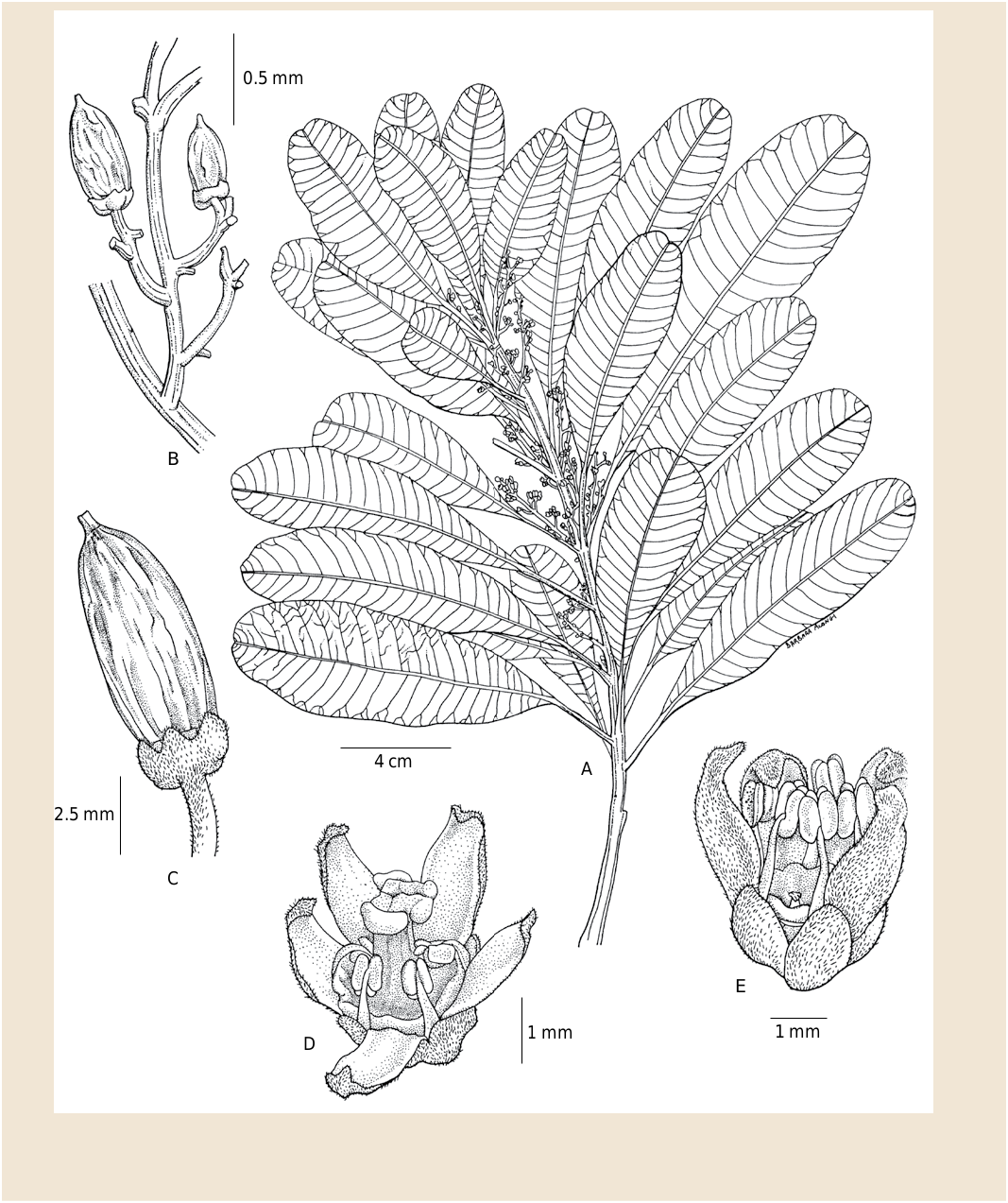
18. Abrahamia littoralis Randrian. & Lowry View in CoL View at ENA , spec. nova ( Fig. 15 View Fig ).
Typus: MADAGASCAR. Prov. Toamasina: Rég. Analanjirofo , Fénérive-Est, Tampolo forestry station, along the “Grand Layon”, just 20 m before the first bridge going toward the Indian Ocean, 0-5 m, 25.X.1996, fl., A. Randrianasolo 509 (holo-: MO- 04895278 !; iso-: G!, K!, P [ P06775163 ]!, TAN [ TAN001996 View Materials ]!, WAG!).
Diagnosis
Abrahamia littoralis Randrian. & Lowry is easily distinguished from its congeners by its medium sized (4-17 3 1.3-5.2 cm), oblanceolate leaves bearing scattered, very often obscure tertiary venation, its long petiole (10-30 mm), and its axillary inflorescences.
Description
Trees 4-15 m tall, 12-18 cm DBH, bark with white milky or translucid latex; young twigs pubescent or ferruginously scabrous. Leaves alternate; blades oblanceolate, 4-17 3 1.3-5.2 cm, coriaceous to subcoriaceous, apex very often shortly acuminate, rounded, retuse or emarginate, margin entire, base acute, adaxial surface sericeous when young, later glabrescent, abaxial surface sericeous when young, glabrescent, venation craspedodromous, slightly prominent adaxially, midvein prominent abaxially, secondary veins c. 25 pairs, more or less parallel, 2-10 mm apart, prominent abaxially, forming an acute angle with the midrib, tertiary veins widely spaced, often obscure on adaxial surface; petiole 10-30 mm long, canaliculate on adaxial surface, pubescent when young, later glabrescent. Inflorescence axillary, a panicle, 2-5 cm long, axes, strigose. Male and female flowers 5-merous; pedicel 0.3-0.5 mm long, with short, appressed indument; calyx lobes triangular, 1.5 3 1 mm, imbricate, adaxial surface glabrous, abaxial surface with short appressed indument, persistent on fruit; corolla lobes narrowly ovate, 2-3 3 c. 1 mm, imbricate, adaxial surface glabrous, abaxial surface strigose, pale yellow, whiter inside; stamens 5. Male flowers with filaments 1.2-1.5 mm long, glabrous, white, anthers 0.8-1 mm long, obloid to slightly ovoid, white, glabrous; disk cupuliform, c. 1.5 mm in diam., glabrous; ovary rudimentary. Female flowers with filaments c. 1 mm long, glabrous, white, anthers c. 0.2-0.3 mm long, subglobose, sterile, white, glabrous; disk c. 1.5 mm in diam., glabrous; ovary widely ovoid to obovoid, c. 1.5 3 c. 1 mm, glabrous, placentation subapical; style very shortly trifid, apical, c. 1-1.1 mm long, glabrous, stigmas capitate. Fruits 2-2.5 3 1-1.5 cm, ellipsoid, slightly asymmetrical, glabrous, with longitudinal striations.
Vernacular names
“Hazombarorana’’, “Tarantana’’.
Distribution, ecology and phenology
Abrahamia littoralis is found in eastern littoral or sublittoral forests near sea level on sandy substrates ( Map 7 View Map 7 ). It flowers in October and very young fruits have been collected in November.
92 Boissiera 71
Conservation status
With an EOO of 18,722 km 2, a minimum AOO of 56 km 2, and 10 recorded localities, with a subpopulation in a single protected area (Agnalazaha), comprising 8 locations subjected to pressure from habitat degradation due to forest exploitation and land clearing, A. littoralis is assigned a preliminary conservation assessment of “Vulnerable” [VU B1ab(iii)+2ab(iii)] using the IUCN Red List Categories and Criteria ( IUCN, 2012).
Notes
With its oblanceolate leaf blade, craspedodromous venation, axillary inflorescence, presence of a rudimentary ovary in male flowers, and glabrous fruit, A. littoralis most closely resembles A. elongata but differs by its much smaller leaves (4-17 3 1.3-5.2 vs 8.5-26.5 3 2.5-6.5 cm), fewer secondary veins (25 vs 25-50), and obscure (vs prominent) tertiary venation on the abaxial surface.
Paratypi
MADAGASCAR. Prov. Fianarantsoa: Farafangana, Mahabo , forêt littorale d’Apoakafo , 23°11’02’’S 47°41’38’’E, 34 m, 19.IX.2003, fl., Ludovic et al. 435 (MO, P, TAN); GoogleMaps ibid. loco, 23°11’10’’S 47°43’02’’E, 30 m, 5.VIII.2004, fl., Ludovic et al. 880 ( G, MO, P, TAN); GoogleMaps ibid. loco, 23°11’S 47°41’E, 21 m, 29.X.2004, fr., Ludovic et al. 928 ( MO, TAN); GoogleMaps Mahabo, Baboaka, forêt d’Andranomainty , 23°10’S 47°44’E, 21 m, s.d., fr., Ludovic & Emilson 1006 ( G, K, MO, P, TAN); GoogleMaps near Mahabo village, 23°10’51’’S 47°42’29’’E, 30 m, 5.XI.2001, fr., McPherson & Rabenantoandro 18338 ( G, K, MO, NY, P, TEF, WAG); GoogleMaps Fokontany Mahabo, Firaisana Mahabo-Mananivo , 23°11’01’’S 47°42’44’’E, 17 m, 6.XI.2001, fr., Rabenantoandro et al. 701 ( MO, P, TAN, TEF); GoogleMaps ibid. loco, 23°11’01’’S 47°42’44’’E, 17 m, 6.XI.2001, y. fr., Rabenantoandro et al. 706 ( MO, P, TAN, TEF); GoogleMaps ibid. loco, 23°10’39’’S 47°43’06’’E, 10 m, 25.IX.2002, fr., Rabenantoandro et al. 1011 ( G, MO, P, TEF); GoogleMaps ibid. loco, 23°11’26’’S 47°43’17’’E, 11 m, 1.IX.2007, bud, Rakotoarivelo 198 ( MO, P, TAN); GoogleMaps ibid. loco, 23°11’13’’S 47°42’27’’E, 22 m, 26.VIII.2003, fl., Razakamalala et al. 708 ( G, K, MO, P, TEF); GoogleMaps Farafangana, Nosiala , [23°12’00’’S 47°42’30’’E], 19.XI.1955,fr., Service Forestier 16211 ( P, TEF) GoogleMaps . Prov.Toamasina: Fénérive-Est, Station forestière de Tampolo, 17°16’52’’S 49°24’44’’E, 0-15 m, 24.I.1995, ster., Raholivelo et al. 150 ( MO); GoogleMaps ibid. loco, 0-5 m, 1.VIII.1996, ster., A. Randrianasolo 467, 467a ( MO, P, TAN); ibid. loco, 25.X.1996, y. fr., A. Randrianasolo 510 ( MO, P, TAN); Brickaville, Vohibola forest , 18°33’39’’S 49°14’33’’E, 27 m, 28.XI.2002, fl., A. Randrianasolo et al. 737 ( G, K, MO, P); GoogleMaps Ambila Lemaitso, [18°49’S 49°08’E], 26.X.1950, y. fr., Service Forestier 1583 ( G, MO, P, TAN, TEF); GoogleMaps Tampolo, [17°17’00’’S 49°23’30’’E], 15.X.1954, fl., Service Forestier 11071 ( MO, P [2 sheets]); GoogleMaps ibid. loco, [17°17’00’’S 49°23’30’’E], 19.X.1955, fl., Service Forestier 15187 ( MO, P, TEF); GoogleMaps ibid. loco, [17°17’S 49°23’E], 28.IX.1957, fl., Service Forestier 17797 ( G, MO, NY, P, TEF); GoogleMaps forêt sublittorale de Vohibola , W de Tampina, [18°31’S 49°17’E], 12-14.VIII.1957, y. fr., Service Forestier 18086 ( G, MO, P [2 sheets]); GoogleMaps forêt sublittorale, entre Foulpointe et l’embouchure de l’Onibe , [17°40’30’’S 49°29’30’’E], 29.IX.1963, fl., Service Forestier 22764 ( P). GoogleMaps Prov. Toliara: Tolagnaro ( Fort-Dauphin ), Mandena Forest , along road SW of QIT Fer et Titane work camp, 24°57’S 47°00’E, 0-10 m, 19.IV.1989, ster., Gereau et al. 3393 ( MO, P, TAN); GoogleMaps Tolagnaro, Ambinanibe, port d’Ehoala , 25°03’S 46°56’E, 2 m, 5.III.2007, ster., Rabenantoandro et al. 1777 ( MO). GoogleMaps Sine loco: s.d., fl., Humblot 358 ( P); GoogleMaps s.d., fl., Louvel 147 ( P). GoogleMaps

No known copyright restrictions apply. See Agosti, D., Egloff, W., 2009. Taxonomic information exchange and copyright: the Plazi approach. BMC Research Notes 2009, 2:53 for further explanation.
|
Kingdom |
|
|
Phylum |
|
|
Class |
|
|
Order |
|
|
Family |
|
|
Genus |