
Pachyprotasis kojimai Taeger & Shinohara
|
publication ID |
https://doi.org/10.11646/zootaxa.4227.4.8 |
|
publication LSID |
lsid:zoobank.org:pub:4933B61B-700C-4F7A-A6CE-83B88359CF82 |
|
DOI |
https://doi.org/10.5281/zenodo.6022935 |
|
persistent identifier |
https://treatment.plazi.org/id/03D0D246-FF9B-A227-D5AA-FE0D6D857FF9 |
|
treatment provided by |
Plazi |
|
scientific name |
Pachyprotasis kojimai Taeger & Shinohara |
| status |
sp. nov. |
Pachyprotasis kojimai Taeger & Shinohara sp. nov.
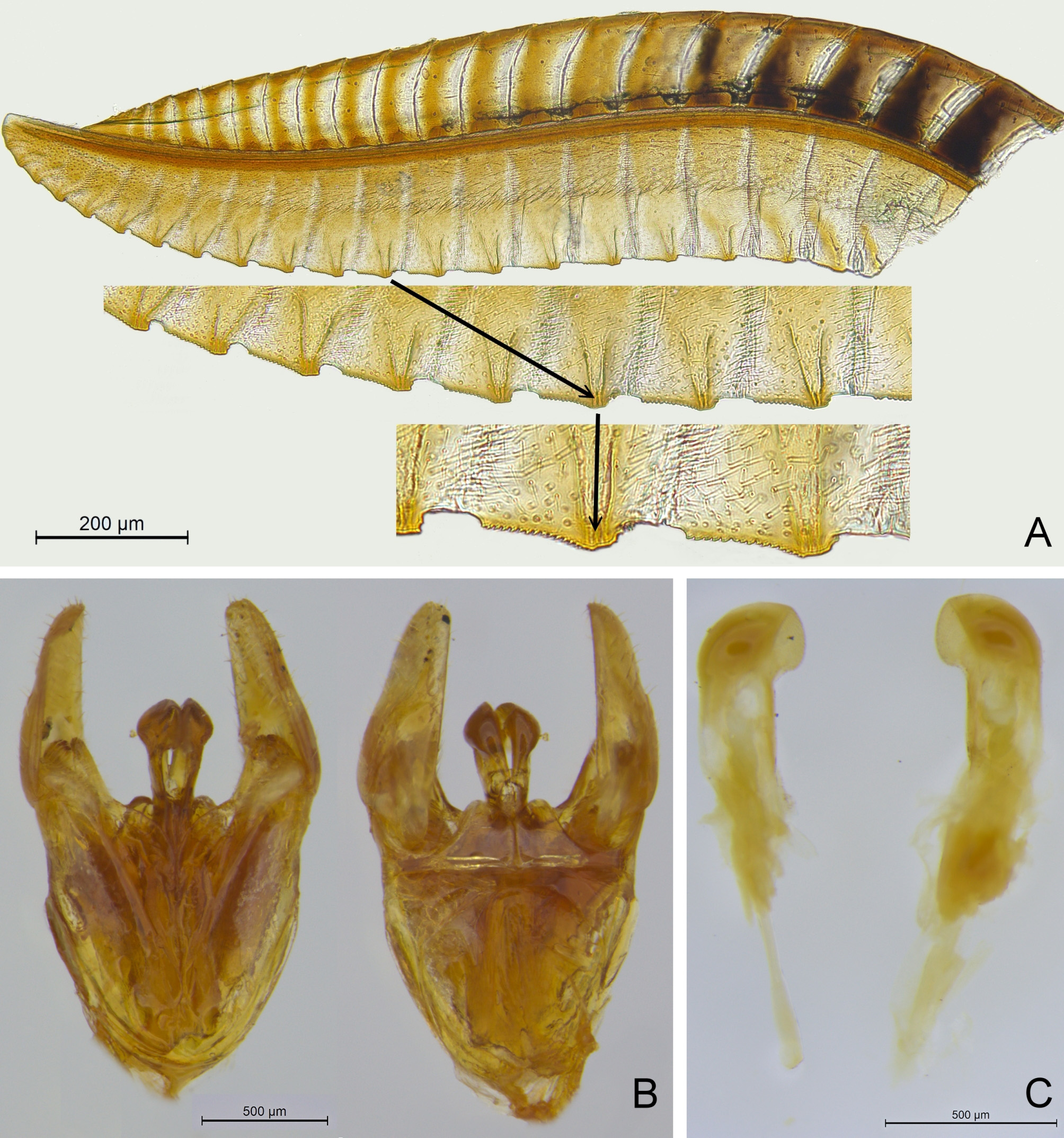
( Figs 1 View FIGURE 1 , 2 View FIGURE 2 , 4 View FIGURE 4 )
Pachyprotasis nigronotata [not Kriechbaumer 1874]: Takeuchi 1952: 20; Togashi 1961: 32; 1965: 246, plate 125, 32; 1970: 63; Naito 1982: 574.
Description. FEMALE ( Figs 1 View FIGURE 1 A–F, 2A): Body length 8.5 mm, fore wing 10.0 mm, antenna about 5.5 mm ( holotype). Antenna filiform, almost not narrowed toward the apex, last antennomere apically blunt. 3rd antennomere about 1.2 × as long as 4th and 2.0 × as long as 8th. 8th antennomere about 4.0 × as long as broad. Head in dorsal view somewhat narrowed behind the eyes. Postocellar area about 1.8 × as broad as long, almost flat and not distinctly higher than the remaining upper head, lateral postocellar furrows deep. Occipital carina prominent and complete. Distance between the lateral ocelli (postocellar line, POL) about 1.5 × as long as diameter of the median ocellus (OD), ocular ocellar line (OOL) 4 × OD, ocellar-occipital carina line (OOCL) nearly 3 × OD. Frontal area with only slightly elevated ridges with shallow furrow between them, antennal furrows shallow. Clypeus apically roundly emarginated to about 0.4 of its length. Labrum apically almost straight, somewhat reflexed. Malar space slightly longer than OD, distance between the toruli about 2 × OD. Head silky shiny, with very shallow microsculpture and few small distant pits. Microsculpture on the remaining body clearly stronger, less shiny, pits more distinct with distances of about 2–5 × their own diameter. Hairs usually clearly shorter than OD. Apical margin of sternum 7 (hypopygium) slightly emarginate. Lancet with rather flat serrulae.
MALE ( Figs 1 View FIGURE 1 G–L, 2B–C): similar to the female; antennae more slender, 8th antennomere almost 6 × as long as broad. Inner tooth of the claw larger than in female.
Color: alive almost completely pale green, dead specimens fading to straw. Antenna dorsally black (scape may be completely pale), pro- and mesotibiae and their tarsi posteriorly black lined, metatibia dorsally black lined and apically black, metatarsus mainly black, metafemur subapically posteriorly black marked. Area between the ocelli, apices of the mandibles, parts of the down bent areas of the lateral mesoscutal lobes, and middle parts of mesopostnotum black marked. Wings hyaline, pterostigma green, remaining veins predominantly dark.
Variability. Body size 8–10 mm. First antennomere (scape) dorsally more or less black lined or completely pale (e.g., holotype). The median mesoscutal groove and the anterior margin of the median mesoscutal lobe may be narrowly black marked. Metatibia either completely black lined, or subapically with green ring (e.g., holotype).
Haploid chromosome number: 10 ( Naito 1982, given for “ P. nigronotata ”); spermatheca: fig. 246 in Togashi (1970), given for “ P. nigronotata ”. COI barcodes see below ( paratypes).
Host plant (s) unknown.
Type material. Holotype ♀, Niigata Pref.: N of Lake Otomi , 36.873°N 138.063°E, 1275 m, 30.07.2016, H. Kojima, NSMT (DEI-GISHym85030). GoogleMaps
Paratypes 10 ♂ 46 ♀ (NSMT, SDEI, USNM, NHRS). Specimens collected by A. Shinohara if not mentioned otherwise. Altitudes in brackets [] are not taken from labels but estimated according to the locality information. Gifu Pref.: 1♀ Shinhotaka-onsen , 36.285°N 137.574°E, [ 1100 m], 23.07.1980 GoogleMaps ; 1♀ Kuriyadani ( Kita Alps ) 36.278°N 137.556°E [ 1200–1900m], 13.08.1977, H. Kumamoto GoogleMaps ; Gunma Pref.: 1♀ Sugenuma–Marunuma , 36.800°N 139.300°E, [ 1450–1750 m], 0 8.07.1979, T. Niisato GoogleMaps ; 1♂ Marunuma , Gunma, 36.834°N 139.347°E, [ 1450 m], 27.06.1980, T. Shimomura GoogleMaps ; Nagano Pref.: 2♀ Kamikochi , 36.250°N 137.633°E, [ 1550 m], 17.07.1927, K. Sato GoogleMaps ; 1♂ Yokoodani, Kamikochi , 36.249°N 137.639°E, 1600–2000 m, 21.07.1989 GoogleMaps – 23.07.1989 (DEI- GISHym85024); 1♂ Yarisawa, Kamikochi , Nagano, 36.256°N 137.653°E, 1600–1900 m, 18.07.1989 GoogleMaps – 22.07.1989 (DEI-GISHym85027); 1♂ 6♀, 1800–2100 m, 18.07.1989 – 22.07.1989; 1 ♂ 31.07.1990; 1♀ Tokusawa, Kamikochi , 36.264°N 137.690°E, [ 1600 m], 17.07.1989 GoogleMaps ; 1♀ 04.08.1989 – 06.08.1989; 1♀ 0 1.08.1989, S. Shinonaga; 1♀ Shimashimadani , 36.170°N 137.778°E, [ 750–2000 m], 25.07.1980 GoogleMaps – 28.07.1980, E. Nishida; 1 ♂ Ichinosawa ( Nagano), 36.334°N 137.772°E, [ 1250–2000 m], 0 1.08.1933, Y. Nakajima GoogleMaps ; 1♀ Mt. Kyogatake, Chuo-Alps , 35.912°N 137.862°E, [ 2250 m], 28.07.1985, K. Mizuno GoogleMaps ; 1♀ Asama ski area, road, 36.412°N 138.440°E, 2000 m, 29.07.2016, A. Taeger (DEI-GISHym86991, KY124264 View Materials ) 2 ♀ same data, H. Kojima GoogleMaps ; 1♀ Omeshidake W, Road 112 (= Mt. Omeshidake, 36-37-30N 138-27-17E, Takayama ), 36.624°N 138.454°E, 1850–1900 m, 22.07.2016 GoogleMaps ; 1♀ 1900 m, 22.07.2016, A. Taeger (DEI-GISHym86990, KY124263 View Materials ); 1♀ same data GoogleMaps ; 1♀ 27.07.2016; 1♀ 27.07.2016, A. Taeger (DEI-GISHym85029); 1 ♀ Makuiwa, Shiga-kogen , 36.704°N 138.485°E, [ 1550 m], 02.06.1985 GoogleMaps ; 1♂ Minoto, Mts. Yatsugatake , 35.982°N 138.336°E, [ 1850 m], 18.07.1980 GoogleMaps ; 1♂ 1♀ 29.07.1986 – 03.08.1986; 2♀ 04.08.1987 – 08.08.1987; 1♀ 04.08.1988 – 08.08.1988; 2♀ 23.07.1996 – 26.07.1996; 2♀ 27.07.1999 – 31.07.1999; 1♂ 1♀ 25.07.2000 – 29.07.2000; 1♀ Ichinose, Yamanouchi , 36.744°N 138.524°E, 1600 m, 20.07.2016 GoogleMaps ; Niigata Pref.: 1♀ N of Lake Otomi (= Sasagamine, 36-52-28N138-03-38E, Myoko ), 36.873°N 138.063°E, 1240 m, 21.07.2016 GoogleMaps ; 1♀ 1275 m, 21.07.2016, A. Taeger (DEI-GISHym86989, KY124262 View Materials ); 1♀ 30.07.2016, A. Taeger (DEI- GISHym86992, KY124265 View Materials ); 1♀ 30.07.2016, H. Kojima; 1♀ same data (DEI-GISHym85028) GoogleMaps ; Tochigi Pref.: 1♀ Yumoto, Oku-Nikko , 36.806°N 139.418°E, [ 1500 m], 26.06.1977 GoogleMaps ; 1♀ 10.06.1978; 1♀ 28.06.1972, T. Saito; 1♂ 1♀ 30.07.1986, T. Saito; Yamanashi Pref.: 1♀ Aoki-kosen–Houougoya , 35.700°N 138.330°E, [ 1100–2400 m], 25.07.1987 GoogleMaps – 25.07.1987, K. Mizuno; 1♀ Sagashio , 35.690°N 138.780°E, [ 1200 m], 25.07.1957, K. Sato. GoogleMaps
Other records (non type material). ( Togashi 1961, as P. nigronotata , specimens not examined) Ishikawa Pref.: Mt. Hakusan : 2♀ Naka-hanba-ato, 36.128°N, 136.750°E [ 1500 m], 07.07.1948 GoogleMaps ; 1♀ 17.07.1954; Takahanba-ato , 36.136°N, 136.761°E [ 1950 m], 1♀ 22.07.1952 GoogleMaps ; Yanagidani 36.128°N, 136.753°E [ 1500 m], 1♀ 24.07. 1955 GoogleMaps .
Distribution. Japan (Honshu).
Etymology. The species is dedicated to Mr. Haruyoshi Kojima ( Nagano).


| NSMT |
National Science Museum (Natural History) |
No known copyright restrictions apply. See Agosti, D., Egloff, W., 2009. Taxonomic information exchange and copyright: the Plazi approach. BMC Research Notes 2009, 2:53 for further explanation.
|
Kingdom |
|
|
Phylum |
|
|
Class |
|
|
Order |
|
|
Family |
|
|
Genus |
Pachyprotasis kojimai Taeger & Shinohara
| Taeger, Andreas, Shinohara, Akihiko & Kramp, Katja 2017 |
Pachyprotasis nigronotata
| Naito 1982: 574 |
| Togashi 1961: 32 |
| Takeuchi 1952: 20 |