
Alvania jeffreysi ( Waller, 1864 )
|
publication ID |
https://doi.org/10.11646/zootaxa.5196.1.1 |
|
publication LSID |
lsid:zoobank.org:pub:1B12892E-D68F-4BFE-8E9A-7F19E220E73D |
|
DOI |
https://doi.org/10.5281/zenodo.7231947 |
|
persistent identifier |
https://treatment.plazi.org/id/03D37947-4866-FFFA-A0B1-F99B43850126 |
|
treatment provided by |
Plazi |
|
scientific name |
Alvania jeffreysi ( Waller, 1864 ) |
| status |
|
Alvania jeffreysi ( Waller, 1864) View in CoL
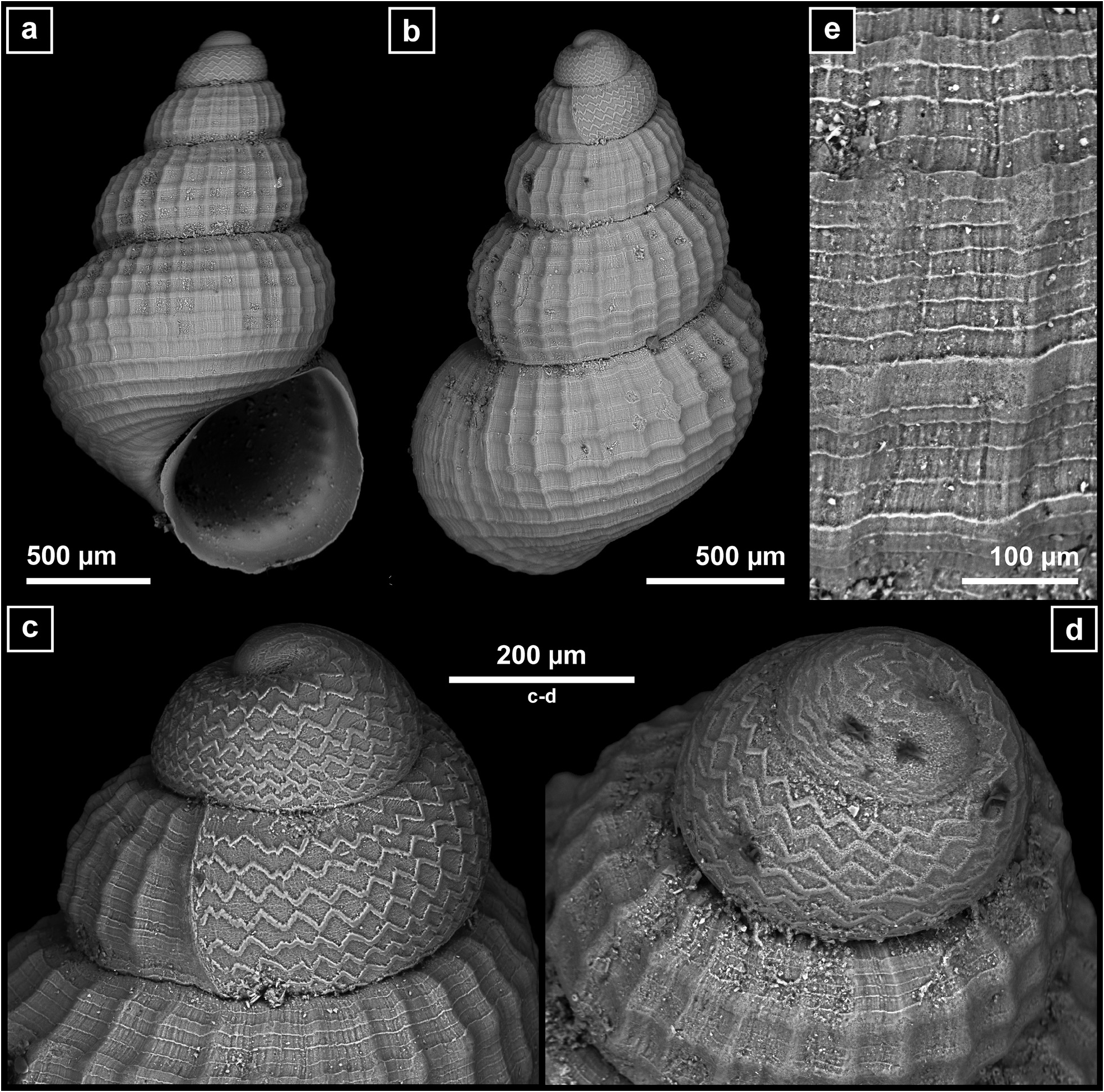
( Fig. 4 View FIGURE 4 )
Material examined. ( more than 250 shells, 154 with soft parts): SPAIN • 1 sPc; 43° 52.823′N, 008° 56.151′W to 43° 52.837′N, 008° 55.597′W; 988– 920 m; 08–15 SeP. 2002; DIVA-Artabria I DRN-1000 GoogleMaps • 2 sh; 43° 53.457′N, 008° 48.461′W to 43° 54.000′N, 008° 48.524′W; 629–631 m; 08–15 SeP. 2002; DIVA-Artabria I AT–600 • 1 sh (juv); 43° 47.188′N, 008° 53.053′W to 43° 55.312′N, 008° 53.101′W; 770–842 m; 08–15 SeP. 2002; DIVA-Artabria I AT-800 GoogleMaps • 3 sPc + 4 sh; 43° 57.030′N, 008° 54.795′W to 43° 57.248′N, 008° 54.133′W; 1191– 1132 m; 08–15 SeP. 2002; DIVA-Artabria I AT-1000 GoogleMaps • 10 sPc + 10 sh (1 juv); 43° 48.421′N, 008° 51.453′W to 43° 49.160′N, 008° 51.091′W; 599–607 m; 10–20 Sep. 2003; DIVA-Artabria I DRN-600 GoogleMaps • 1 sPc; 43° 53.575′N, 008° 56.868′W to 43° 54.015′N, 008° 56.959′W; 965–974 m; 10–20 Sep. 2003; DIVA-Artabria I DRN-1000 GoogleMaps • 1 sh; 43° 48.514′N, 008° 51.439′W to 43° 49.163′N, 008° 51.157′W; 616– 616 m; 10–20 SeP. 2003; DIVA-Artabria I AT-600 GoogleMaps • 1 sh (juv); 43° 42.348′N, 008° 45.889′W to 43° 43.269′N, 008° 45.289′W; 344–354 m; 10–20 SeP. 2003; DIVA-Artabria I EBS-350 GoogleMaps • 90 sPc + 20 sh; 43° 48.587′N, 008° 51.402′W to 43° 49.545′N, 008° 51.197′W; 610– 598 m; 10–20 SeP. 2003; DIVA-Artabria I EBS-600 GoogleMaps • 3 sh; 43° 51.873′N, 008° 53.683′W to 43° 53.120′N, 008° 53.301′W; 802– 788 m; 10–20 SeP. 2003; DIVA-Artabria I EBS-800 GoogleMaps • 2 sPc + 2 sh; 43° 38.812′N, 009° 07.949′W to 43° 39.841′N, 009° 07.405′W; 999–1001 m; 17–28 SeP. 2004; VERTIDOS GA-DRN-1000 SARRIDAL (2006–07) GoogleMaps • 2 spc + 11 sh; Polygon delimited by Points 44° 10.000′ N, 009° 00.000′ W /44° 10.000′ N, 008° 35.000′ W/44° 00.000′ N; 009° 00.000′ W/44° 07.000′ N; 008° 35.000′ W; 480–600 m; SARRIDAL (2006–2007) SARRI-2 • 5 sPc + 5 sh; Polygon delimited by Points 44° 10.000′ N, 009° 00.000′ W /44° 10.000′ N, 008° 35.000′ W/44° 00.000′ N; 009° 00.000′ W/44° 07.000′ N; 008° 35.000′ W; 417–668 m; SARRIDAL (2006–07) SARRI-3 • 5 sPc + 1 sh; Polygon delimited by Points 44° 10.000′ N, 009° 00.000′ W /44° 10.000′ N, 008° 35.000′ W/44° 00.000′ N; 009° 00.000′ W/44° 07.000′ N; 008° 35.000′ W; 417–668 m; SARRIDAL (2006–2007) SARRI-4 • 19 sh; 44° 11.652′N, 008° 58.152′W to 44° 11.539′N, 008° 57.574′W; 908–1106 m; 15–24 Jul. 2008; A SELVA DRN-7 GoogleMaps • >50 sh; 44° 08.65′N, 008° 55.305′W to 44° 08.771′N, 008° 55.104′W; 581– 566 m; 15–24 Jul. 2008; A SELVA DRN-7 C GoogleMaps • 3 sh; 44° 08.461′N, 009° 04.634′W to 44° 08.607′N, 009° 04.413′W; 917– 896 m; 15–24 Jul. 2008; A SELVA DRN-7-1 GoogleMaps • 30 sPc + 70 sh; 44° 09.896′N, 008° 39.581′W to 44° 10.129′N, 008° 39.494′W; 438–459 m; 15–24 Jul. 2008; A SELVA DRN-11 GoogleMaps • 5 sh; 44° 07.309′N, 008° 48.289′W to 44° 07.488′N, 008° 48.047′W; 44° 5–438 m; 15–24 Jul. 2008; A SELVA DRN-11-5 GoogleMaps • 1 sPc; 43° 48.511′N, 008° 51.393′W to 43° 49.092′N, 008° 50.959′W; 312–576 m; 15–24 Jul. 2008; A SELVA DRN-30-1 GoogleMaps • 1 sPc + 1 sh; 44° 07.495′N, 008° 46.999′W to 44° 07.675′N, 008° 45.225′W; 416– 407 m; 15–24 Jul. 2008; A SELVA AT-11-2 GoogleMaps • 1 sh; 44° 14.929′N, 008° 30.255′W to 44° 15.367′N, 008° 30.438′W; 2121–2516 m; 15–24 Jul. 2008; A SELVA AT-12 GoogleMaps • 7 sPc; 43° 58.84′N, 008° 15.625′W to 43° 59.621′N, 008° 14.285′W; 233–237 m; 15–24 Jul. 2008; A SELVA EBS-20 GoogleMaps • 3 sPc (juv); 43° 48.252′N, 008° 51.427′W to 43° 49.707′N, 008° 51.164′W; 575–584 m; 15–24 Jul. 2008; A SELVA EBS-30-1 GoogleMaps • 2 sh; 43° 34.86′N, 009° 21.95′W to 43° 36.44° ′N, 009° 20.71′W; 1010–1112 m; 15–30 SeP. 2008; DIVA-Artabria II EBS-04 GoogleMaps .
Remarks. It extends from higher latitudes (southeastern Greenland, Iceland, and Scandinavia) southwards to Portugal, usually in 50–500 m ( Rodríguez-Babío & Thiriot-Quiévreux 1974; Fretter & Graham 1978; Bouchet & Warén 1993; Warén 1996; Hoffman et al. 2011). The shells studied show the characteristic square reticulate sculpture ( Figs. 4a–b View FIGURE 4 ). High magnification reveals minute spires and fuzzy growth lines ( Fig. 4e View FIGURE 4 ). Blunt protoconch with a marked zigzag sculpture ( Figs. 4c–d View FIGURE 4 ).
According to Gofas & Warén (1982) records from the Mediterranean are based on Alvania sororcula GranataGrillo, 1877 . Alvania jeffreysi is characterized by the zig-zag sculpture of its protoconch ( Figs. 4 c–d View FIGURE 4 ), which it shares with some sublittoral Alvania , such as A. zylensis Gofas & Warén, 1982 , A. imperspicua ( Pallary, 1920) and A. vermaasi van Aartsen, 1975 .
In the studied samples it was present between 300 and 1000 m, mainly in the range 400–650 m where many shells had remains of the soft parts. It was abundant in the same samples than Alvania cimicoides .
No known copyright restrictions apply. See Agosti, D., Egloff, W., 2009. Taxonomic information exchange and copyright: the Plazi approach. BMC Research Notes 2009, 2:53 for further explanation.
|
Kingdom |
|
|
Phylum |
|
|
Class |
|
|
SubClass |
Caenogastropoda |
|
Order |
|
|
Family |
|
|
Genus |