
Oropuella sp. F
|
publication ID |
https://doi.org/10.5324/cjcr.v0i33.3068 |
|
DOI |
https://doi.org/10.5281/zenodo.7996072 |
|
persistent identifier |
https://treatment.plazi.org/id/266E87F8-FFFF-A479-FC91-42AABD7FFEB7 |
|
treatment provided by |
Felipe |
|
scientific name |
Oropuella sp. F |
| status |
|
Material examined: USA. WASHINGTON: Pend Oreille Co., North Fork Sullivan Creek , 48.8607°N, 117.3272°W, 19.vii.2017, WADOE17SE004 ( 1 female pupa (slide) [ AFPC]) GoogleMaps .
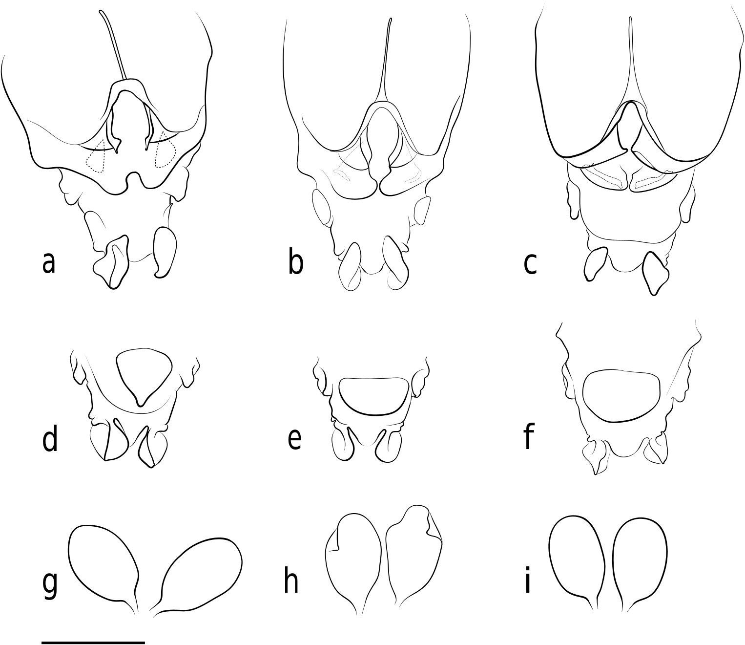
Diagnostic characters: Adult female. Tergite IX semicircular, with ~11 setae. Gonapophysis VIII dorsomedial lobes nearly touching at apex.
Description: Adult female (pharate). Figs 1d View Figure 1 , 3c, f, i View Figure 3 . Measurements (n = 1): flagellomeres (μm): 51, 41, 40, 41, 62; AR 0.35; spermathecae 157–159 x 102. Tergite IX semicircular. Gonapophysis VIII dorsomedial lobes nearly touching medially, apex broadly pointed; ventrolateral lobes separate.
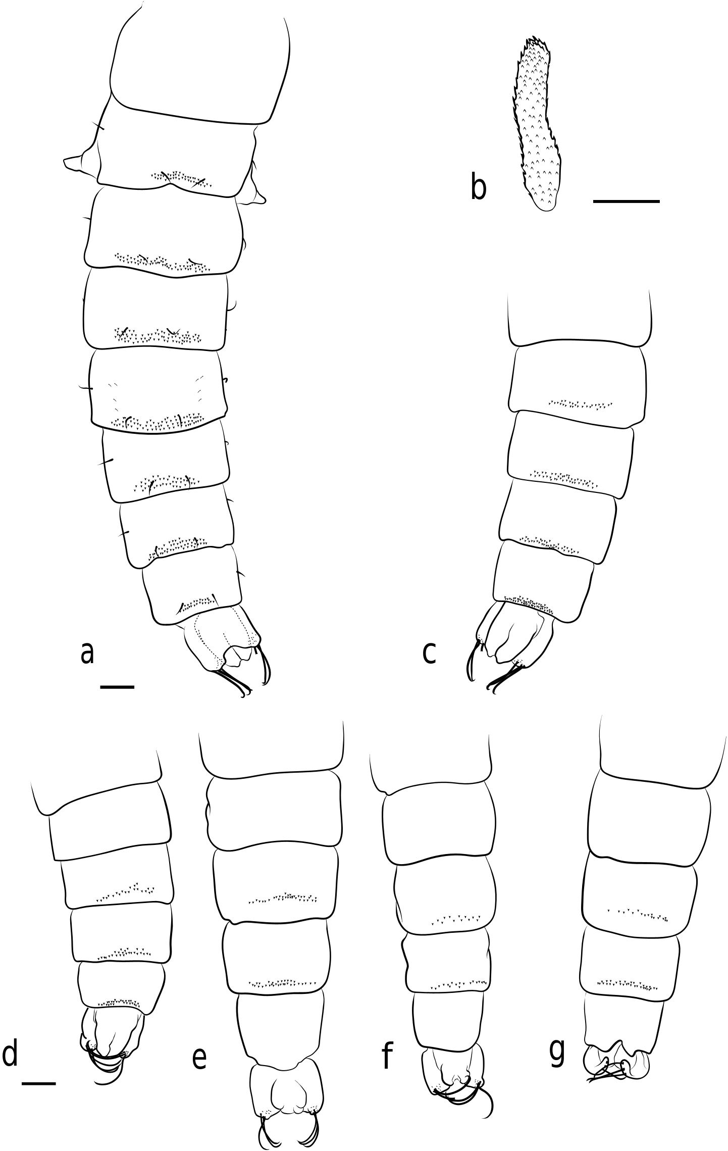
Pupa. Fig. 4g View Figure 4 . Measurements (n = 1): length 2.5 mm. Sternites VI–VII with posterior spinule band.
Oropuella unassociated larval material: USA. CALIFORNIA: Lassen Volcanic National Park, Manzanita Creek, 40.5373°N, 121.5926°W, 21.viii.2017, NPS17LAS010 ( 1 larva (slide) ANSP-ENT-124838 [ ANSP]); GoogleMaps Redwood National Park , Godwood Creek , 41.3704°N, 124.026°W, 11.vi.2018, NPS18 REDW002 ( 2 larvae (slide) ANSP-ENT-124836–124837 [ ANSP]); GoogleMaps Redwood National Park, Unnamed Streelow Creek Trail , 41.3465°N, 124.0387°W, 6.vi.2018, NPS18 REDW003 ( 1 larva (alcohol) ANSP-ENT-124839 [ ANSP]). GoogleMaps MONTANA: Granite Co., Lolo National Forest, Butte Cabin Creek, 46.512°N, 113.745°W, 29.v.2016, leg. A Fasbender ( 1 larva (slide) [ AFPC]); GoogleMaps Lewis and Clark Co., Dearborn River Middle Fork downhill from Hwy 200, 47.0914°N, 112.3618°W 27.ix.2017. MTDEQ17 REF4005 ( 8 larvae (alcohol) [ AFPC]). GoogleMaps OREGON: Crater Lake National Park, Sun Creek , 42.8656°N, 122.08647°W 12.ix.2018, NPS18CRLA026 ( 3 larvae (slide) ANSP-ENT-124833–124835 [ ANSP]); GoogleMaps Josephine Co., Booze Creek at RM 0.2, 42.6596°N, 123.6597°W 24.viii.2017, ODEQ17 SH031 ( 1 larva (alcohol) [ AFPC]); GoogleMaps Oregon Caves National Monument, Cave Creek , 42.098°N, 123.411°W, 2.vi.2015, NPS15 ORCA001 ( 1 larva with pharate pupa ANSP-ENT-124832, 4 larvae (slide) ANSP-ENT-124828–124831 [ ANSP]; GoogleMaps 1 larva sequenced). WASHINGTON: King Co., Vashon Island, Judd Creek, 28A_17, 47.4034°N, 122.4688°W, 3.viii.2017, KC17VAS003 ( 1 larva (slide) [ AFPC]); GoogleMaps Pierce Co., Huckleberry Creek , 47.0085°N, 121.6173°W 2.viii.2017, WADOE17 AM006 ( 3 larvae (alcohol) [ AFPC]). GoogleMaps

| ANSP |
Academy of Natural Sciences of Philadelphia |
| RM |
McGill University, Redpath Museum |
No known copyright restrictions apply. See Agosti, D., Egloff, W., 2009. Taxonomic information exchange and copyright: the Plazi approach. BMC Research Notes 2009, 2:53 for further explanation.
|
Kingdom |
|
|
Phylum |
|
|
Class |
|
|
Order |
|
|
Family |
|
|
SubFamily |
Orthocladiinae |
|
Genus |