
Kukulcania geophila ( Chamberlin and Ivie, 1935 )
|
publication ID |
https://doi.org/10.1206/00030090-426.1.1 |
|
DOI |
https://doi.org/10.5281/zenodo.4429025 |
|
persistent identifier |
https://treatment.plazi.org/id/5406C22A-0AD9-21AF-C03A-FE3A2E7E43D6 |
|
treatment provided by |
Plazi |
|
scientific name |
Kukulcania geophila ( Chamberlin and Ivie, 1935 ) |
| status |
|
Kukulcania geophila ( Chamberlin and Ivie, 1935) View in CoL
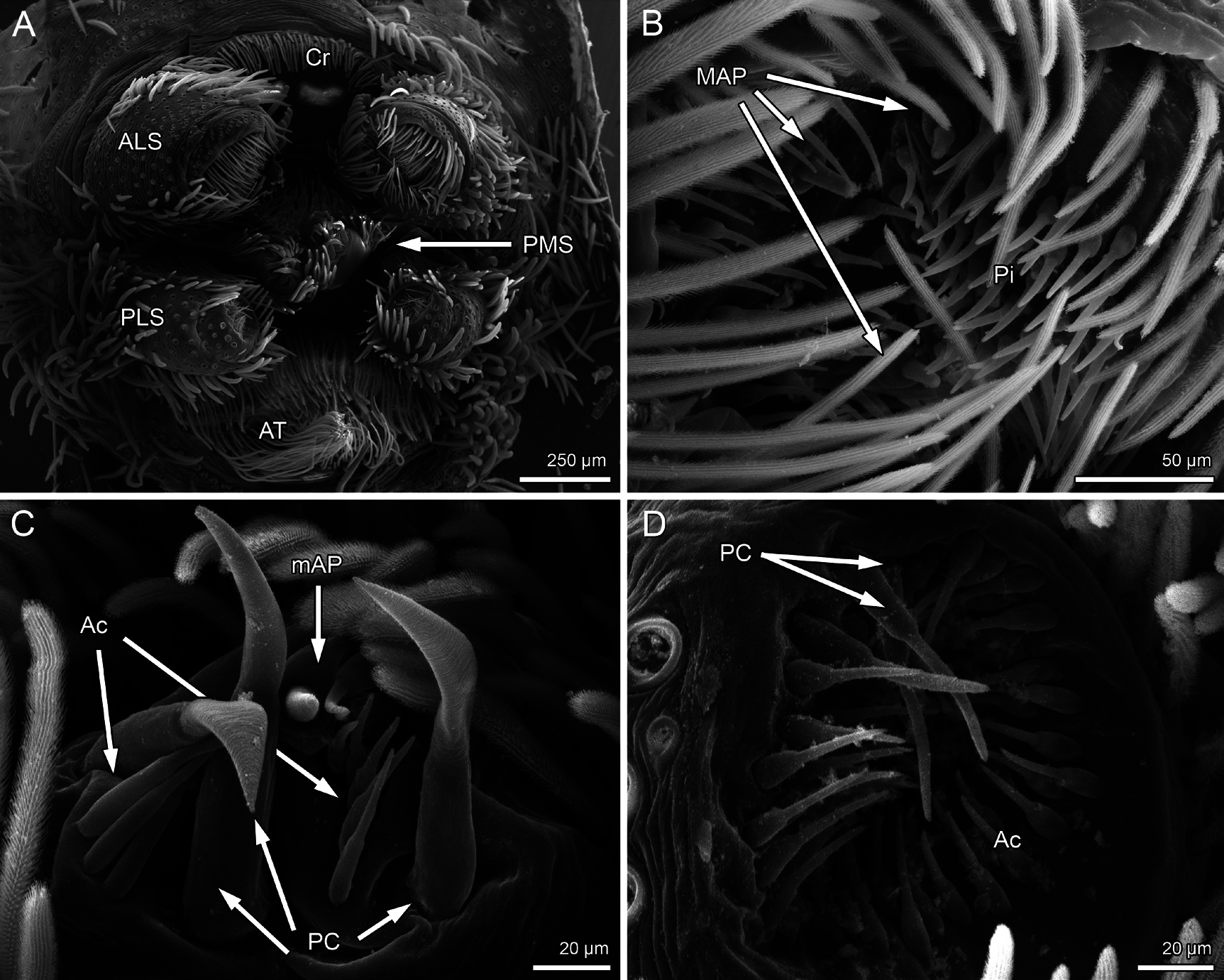
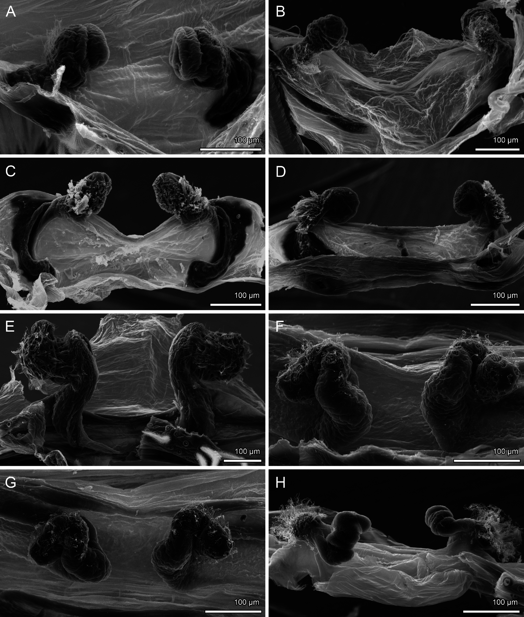
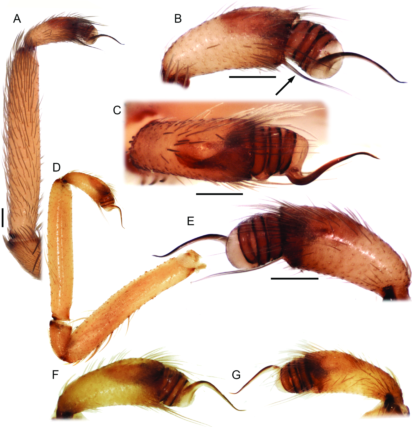
Figures 2E View FIGURE 2 , 4B View FIGURE 4 , 5B View FIGURE 5 , 6E View FIGURE 6 , 9 View FIGURE 9 D–E, 12 View FIGURE 12 , 16 View FIGURE 16 , 17 View FIGURE 17 , 24–25 View FIGURE 24 View FIGURE 25 , 27 View FIGURE 27 G, 28 View FIGURE 28 G, 29 View FIGURE 29 G, 31 View FIGURE 31 H, 79–82 View FIGURE 79 View FIGURE 80 View FIGURE 81 View FIGURE 82
Filistata geophila Chamberlin and Ivie, 1935: 6 , plate 4, f. 22–23. Male and female types from California (AMNH), examined.
Filistata geophila wawona Chamberlin and Ivie, 1942: 4 . NEW SYNONYMY. Female holotype from California (AMNH), examined.
Kukulcania geophila: Lehtinen, 1967: 242 View in CoL .
Kukulcania View in CoL sp.: Ubick, 2005: 81, fig. 28.3; Ubick, 2017: 117, fig. 30.3.
EXAMINED TYPE MATERIAL: HOLOTYPES: USA: California: San Mateo Co.: Palo Alto, Menlo Park [N37.45276°, W122.18164°], J.C. Chamberlin, 1920,♂, in the same vial as the allotype♀ (AMNH); Mariposa Co .: Yosemite Park, Wawona camp [N37.53689°, W119.65701°], 17.ix.1941,♀ holotype of F. g. wawona (AMNH IFM-1225). PARATYPES: California: Inyo Co .: Mount Whitney (Nast base) [N36.58825°, W118.22946°], W. Ivie, 8.viii.1931, 1♀ (AMNH); San Luis Obispo Co.: 10 miles S San Luis Obispo [N35.17588°, W120.61716°], 19.vii.1934, 1♀ 2 imm. (AMNH); Santa Barbara Co.: Santa Cruz Island [N34.02321°, W119.76577°], R.V. Chamberlin, iv.1913, 2♀ (AMNH IFM-1539); Santa Clara Co.: Palo Alto [N37.44188°, W122.14302°], J.C. Chamberlin, 17.xii.1920, 2♀ (AMNH IFM-1536); Los Angeles Co.: Santa Monica [N34.01945°, W118.49119°], W. Ivie, 19.xii.1933, 3 imm. (AMNH).
REMARKS: The holotype of Filistata geophila wawona does not differ in morphology from females of the nominotypical subspecies and we see no reason to retain this name as valid.
DIAGNOSIS: Males are very similar to K. benita : the cymbium has two strong setae in the prolateral face, the bulb has a semicircular base and the embolus is thin and loosely has the shape of an S. Males of K. geophila can be distinguished by the shorter palpal tibia (fig. 80) (between 5.1× and 6.1× longer than higher in K. geophila , 8.1 in the single known male of K. benita ). Females are similar to K. benita and some populations of K. bajacali in lacking sclerotized bars and having a small, semicircular glandular portion of the spermathecae apex sided by the membranous portion. They can be distinguished by the long, fingerlike membranous portion of the spermathecae apex with a proximal ~90° bend (fig. 82).
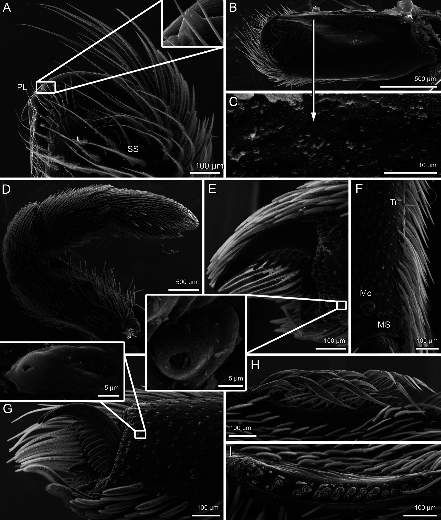
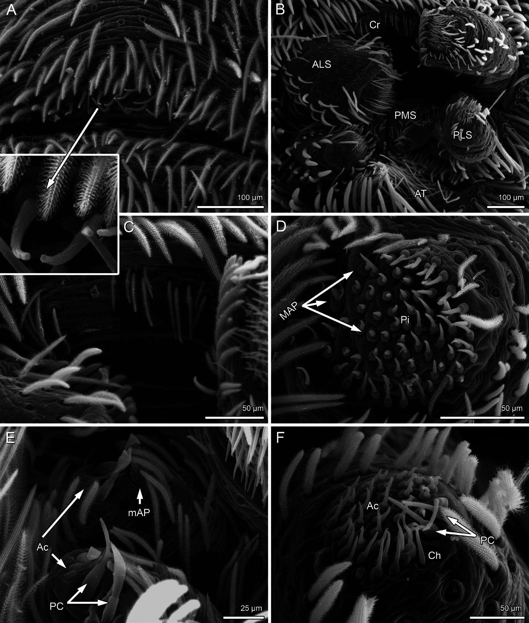
DESCRIPTION: Male from Stanislaus Co., California (CAS 9057841). Coloration yellowish cream. Carapace with dark brown, V-shaped median pattern. Abdomen dorsum grayish cream. Sternum oval, with two pairs of barely visible sigillae. Total length 6.59. Carapace length 3.04, width 2.32, clypeus length 0.27. Eye diameters and interdistances: AME 0.135; PME 0.177; ALE 0.205; PLE 0.183; AME–AME 0.056; PME–PME 0.18. Sternum length 1.46, width 1.27. Palp: femur length 2.31, height 0.36; tibia length 2, height 0.35. Leg I: femur (fe) 4.13; patella (pa) 1.34; tibia (ti) 4.09; metatarsus (mt) 4.12; tarsus (ta) 1.7. II: fe 3.49; pa 1.12; ti 3.03; mt 3.38; ta 1.4. III: fe 3.2; pa 1.01; ti 2.74; mt 3.3; ta 1.66. IV: fe 4.32; pa 1.2; ti 4.12; mt 4.56; ta 1.78. Abdomen: length 3.73, width 1.97. Palp macrosetae long, in several rows along femur ventral and dorsal faces. Leg macrosetae: fe I 6d, 11p, 27v, 2r, all very short; ti I 7p, 8v; mt I 6p, 12v, 1r; fe II 8d, 5p, 18v, 3r; ti II 3p, 7v; mt II 4p, 11v, 3r; fe III 6d, 5p, 11v, 5r; ti III 1d, 3p, 6v, 2r; mt III 1d, 4p, 10v, 3r; fe IV 8d, 3p, 14v, 2r; ti IV 1p, 7v, 2r; mt IV 3p, 9v, 1r; tarsal macrosetae present but indistinct. Palp: cymbium long, with prolateral edge slightly protruding and bearing two strong setae; bulb short, semi- circular at base; sperm duct with three coils; embolus long, sinuous. State of the specimen: good, left palp and left leg I dissected, right legs II and III set apart for DNA extraction.
Female from San Joaquin Co., California (CAS 9057589). Coloration brown. Carapace light brown, lined and stippled with dark brown, with brown V-shaped pattern posteriorly to the eyes. Sternum and coxae yellowish brown. Legs brown, with orange longitudinal stripes on coxae, femora, and tibiae. Anterior margin of the carapace unmodified. Sternum oval, with two pairs of sigillae. Total length 7.64. Carapace length 3.15, width 2.46, clypeus length 0.37. Eye diameters and interdistances: AME 0.14; PME 0.198; ALE 0.23; PLE 0.22; AME–AME‰.07; PME–PME 0.18. Sternum length 1.5, width 1.41. Palp: femur length 1.63, height 0.66; tibia length 0.93, height 0.57. Leg I: femur (fe) 3.35; patella (pa) 1.28; tibia (ti) 2.98; metatarsus (mt) 2.84; tarsus (ta) 1.51. II: fe 2.54; pa 0.88; ti 1.98; mt 1.86; ta 1.13. III: fe 2.18; pa 0.97; ti 1.71; mt 1.68; ta 1.03. IV: fe 3.13; pa 1.2; ti 2.5; mt 2.38; ta 1.27. Abdomen: length 4.82, width 3.21. Palp macrosetae on ventral surface of tibia and tarsus. Leg macrosetae present on ventral surfaces of tibiae, metatarsi and tarsi; all femora and metatarsi III with 2–4 dorsal macrosetae. Calamistrum with three rows of setae with 8–9 setae each. Interpulmonary fold large, rounded, covering the spermathecae dorsally. Sclerotized lateral bars absent; membranous portion of the spermathecae apex long, finger shaped, with a 90° bend; glandular portion semicircular, sclerotized. State of the specimen: good, genitalia dissected.
INTRASPECIFIC VARIATION: Males ( N = 5): total length 5.76–7.6 (6.45), carapace length 2.55–3.04 (2.73), femur I length 3.7–4.3 (3.97), tibia I length 3.7–4.09 (3.86), femur/carapace ratio 1.36–1.52 (1.45). Females ( N = 5): total length 7.05–12.21 (9.99), carapace length 2.89– 5.35 (4.1), femur I length 3.12–5.6 (4.24), tibia I length 2.98–4.95 (3.95), femur/carapace ratio 1–1.08 (1.04). The shape of the bulb is slightly variable (fig. 80).
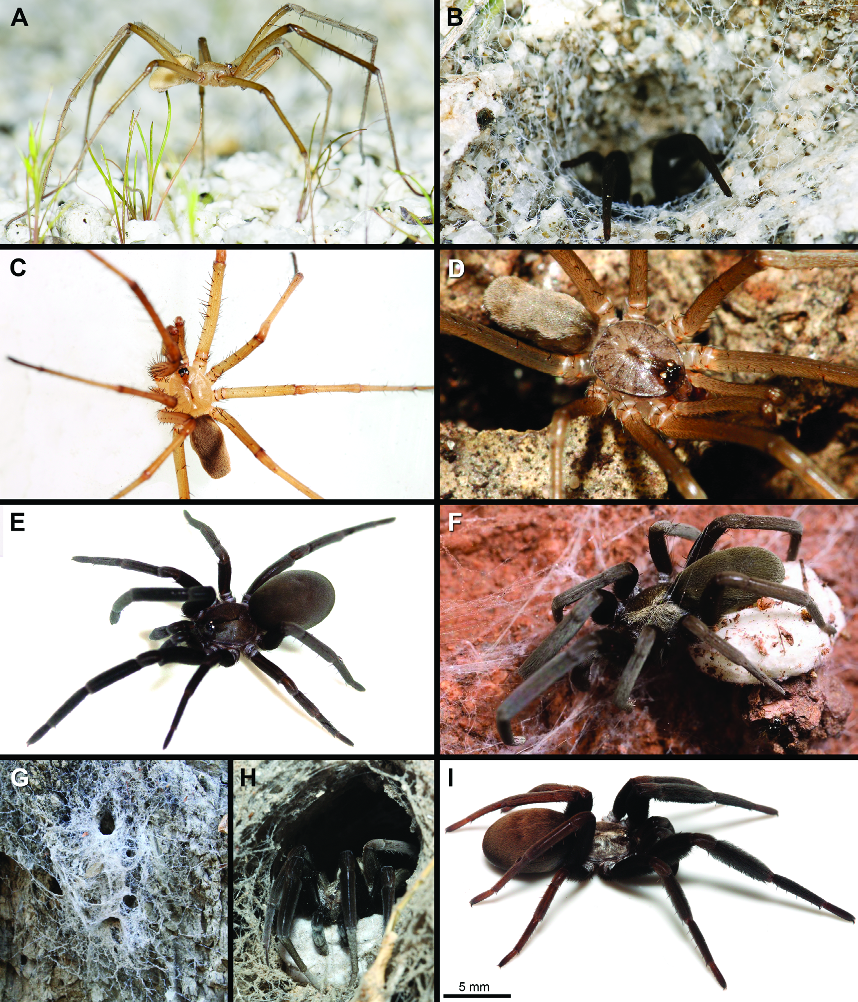
NATURAL HISTORY: Label data indicate specimens have been collected in broadleaf forest, citrus litter, chaparral ravines, grasslands, and pine / oak /manzanita/ juniper forest, under loose Eucalyptus bark, rocks, granite, and serpentine, and in synanthropic settings (gardens, stores, around buildings). Cokendolpher and MacDonald (2008) reported egg sac–guarding by the female and cooperative prey capture and group feeding by spiderlings in this species.
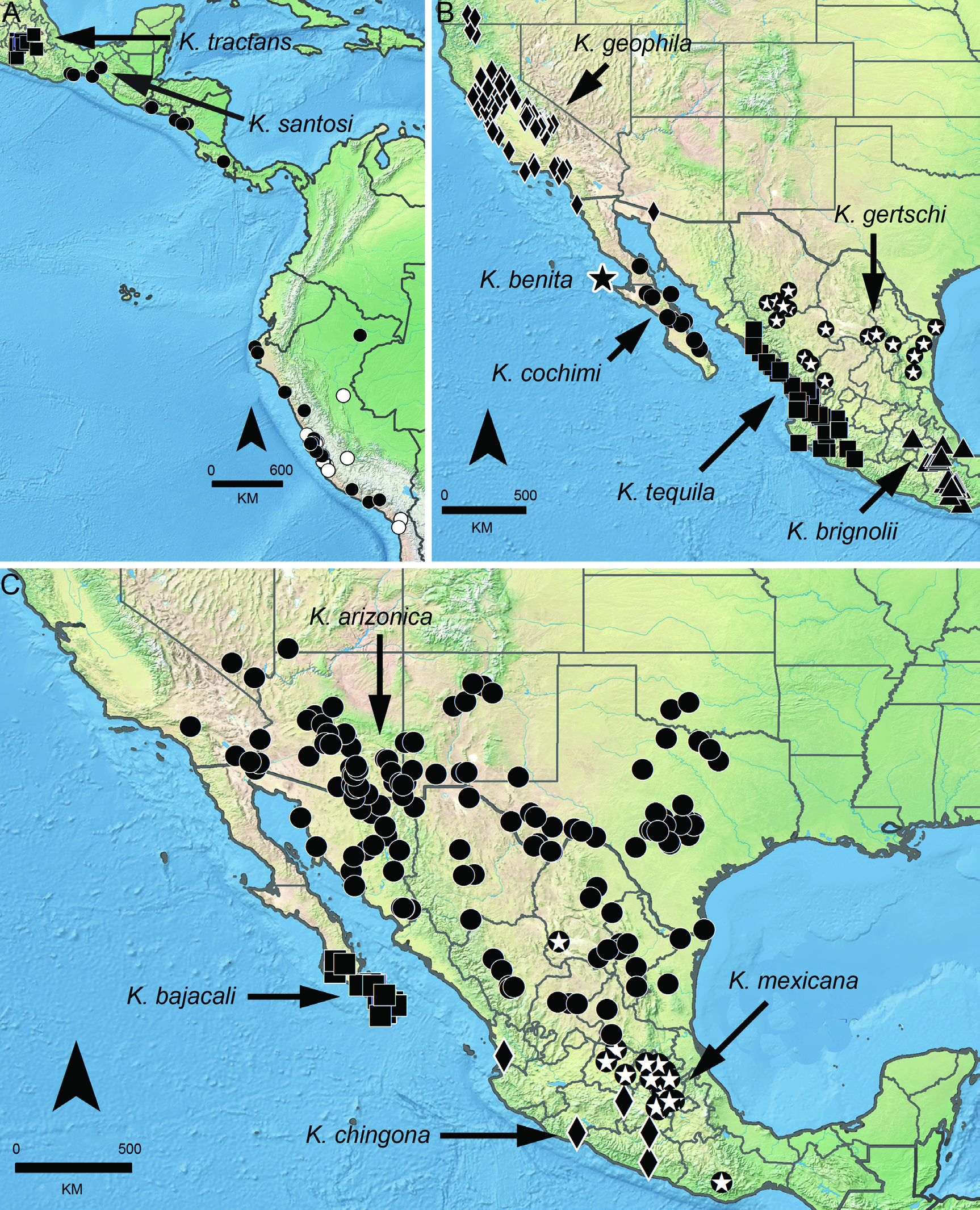
DISTRIBUTION: United States, California, with a few records in adjacent areas of Oregon and Arizona, and the Mexican state of Baja California (fig. 4B).
ADDITIONAL MATERIAL EXAMINED: MEXICO. Baja California: 21.4 miles S Tijuana, near Halfway house Marker K35 on Mex#1 R.B. 3 [N32.25293°, W116.95257°], P.R. Craig and D.L. Dailey, 20. xi.1962, 2♂ (CAS 9058495). USA: Arizona: Pima Co .: 38 miles S Ajo [N31.88498°, W112.8144°], S. and D. Mulaik, 4.i.1941, 1♀ (AMNH). California: Alameda Co.: Castro Valley [N37.6941°, W122.08635°], W.M. Pearce, 18.iii.1941, 2♀ (AMNH); Amador Co.: 3 miles S Jackson, canyon on highway [N38.3488°, W120.7741°], V. Roth, 7. vii.1958, missing spermathecae, 1♀ (AMNH); 7 miles E Pioneer, highway 88, sugar pine forest (N38.4999°, W120.5033°, 1250m), M. Hedin, 22. xi.2006, 1♂ (SDSU); Pardee Res. Ranger Sta., under rocks [N38.2873°, W120.87012°], D. Ubick, 24.i.1981, 1♀ (DU 81.01.24); Butte Co.: Oroville [N39.51378°, W121.55636°], R.O. Schuster, 12.i.1956, 1♀ (UCB); Colusa Co .: Williams [N39.15461°, W122.14942°], 30.viii.1955, 1♀ 1 imm. (AMNH); Contra Costa Co.: 4 miles S Antioch [N38.00492°, W121.80579°], R.F. Smith, 9.iv.1945, 1♀ (AMNH); 4 miles W Byron [N37.89466°, W121.71392°], 2.iv.1945, 1♀ 1 imm. (AMNH); Clayton [N37.94103°, W121.93579°], 16.iv.1939, 1♀ (AMNH); W.M. Pearce, 28.iv.1940, 1♀ (AMNH); 9.viii.1940, 1♀ (AMNH); Mount Diablo [N37.88159°, W121.91415°], W.J. and J.W. Gertsch, 21.vii.1953, 1♀ (AMNH); Mt. Diablo State Park, 0.5 mile W Jumper Cmpgnd., beneath rock [N37.88159°, W121.91415°, 823m], C.E. Griswold, 11.vi.1975, 1♀ (UCB); San Joaquin Valley [N37.98326°, W121.86774°], R. Schick, 16–31.vii.1955, 2♀ (AMNH); El Dorado Co.: 0.2 mile NE Anderson Ck., on Rattlesnake Bar Road, oak-pine [N38.77712°, W121.10272°], D. Ubick, 4.ii.1995, 1♀ (CAS 9060447); 1.5 mile S Latrobe [N38.55963°, W120.98383°], C.E. Griswold, 5.iv.1981, 1♂ (UCB); 5 miles N Pollock Pines [N38.76129°, W120.58659°], W.J. Gertsch and V. Roth, 6.vii.1958, with egg sac, missing genitalia, 1♀ (AMNH); Folsom Lake [N38.77712°, W121.10272°], C.E. Griswold, 4. iv.1981, 1♀ (UCB); Fresno Co.: Fresno [N36.74684°, W119.77259°], R.O. Schuster, 21.iii.1956, 2♀ (UCB); near Prather [N37.03745°, W119.51402°], 26.vi.1956, 1♀ (AMNH); Shaver Lake [N37.10411°, W119.31763°], W.J. Gertsch and V. Roth, 12.ix.1959, 1♀ (AMNH); Los Angeles Co.: Angeles National Forest, Vic. Henninger [N34.31582°, W118.00609°], M.E. Thompson, 13.iv.1968, 1♂ (AMNH); 21. xii.1967, 1♂ (AMNH); Eaton Canyon Park [N34.17698°, W118.09707°], 26.ii.1968, 1♂ (AMNH); Fish Canyon [N34.15208°, W117.92899°], E.I. Schlinger, 1.ii.1950, 1♂ (AMNH IFM-1647); [N34.16832°, W117.9263°], 28.v.1944, 1♀ (AMNH); San Dimas, Canyon near Claremont [N34.09668°, W117.71978°], V. Roth, 2.ix.1956, 1♀ (AMNH); San Gabriel Mountains, Angeles National Forest, Highway 3, 1.3 km W junction with Big Tujunga Canyon Road, forest/chaparral ravine (N34.2907°, W118.1706°, 1030m), M. Hedin, J. Satler, J. Starret and C. Richart, 15.ii.2009, 1♂ (SDSU); Big Tujunga Canyon [N34.2907°, W118.1706°], R. Schick, 15–22.i.1956, 1♀ 1 imm. (AMNH); Tanbark Flats, W.J. Gertsch, 20.vi.1952, 2♀ 1 imm. (AMNH); West Fork [N34.24161°, W117.87034°], M.E. Thompson, 1.iii.1968, 1♂ (AMNH); Madera Co .: Exper. Range [N37.09939°, W119.74015°], 29.ix.1972, 1♂ (CAS 9060444); Millerton Lake Campground, N side of lake, E of Madera (N37.0197°, W119.6693°, 150m), M. Hedin, 26.iii.2009, 1♂ (SDSU); Northfork [N37.22938°, W119.50938°], H. Dietrich, iii.1920, 4♀ (AMNH); Marin Co.: Novato, under serpentine [N38.10742°, W122.5697°], D. Ubick, 7.iii.1983, 1♂ (DU 82.03.07); Simmons Lane Open Space, D. Ubick and I. Budi, 21.vi.1991, 1♀ (CAS 9060479); San Anselmo, Phoenix Lake [N37.95329°, W122.57805°], R. Brady, 17.iv.1982, 1♀ (AMNH); San Francisco, Mount Tamalpais [N37.92354°, W122.59647°], J.H. Emerton, xi.1905, 1♀ (MCZ 145413); Monterey Co.: Arroyo Seco, Indians Road (N36.23°, W121.49167°, 343m), D. and S. Ubick, 25.i–11.vi.2003, 1♂ (DU 03.06.11); under rocks and litter (N36.22°, W121.49167°, 343m), 15.iv.2000, 1♂ (DU 00.04.15); S of Lakes, under granite and oak litter [N36.22°, W121.49167°, 900m], D. Ubick and J. Boutin, 13–15.v.1994, 1♀ (DU 94.05.13); Hastings Natural History Reserve [N36.36667°, W121.55°], J.M. Lindsale, 10.v.1941, 1♀ (CAS 9057623); Jolon [N35.9708°, W121.17603°], E. Ray, 28.ii.1944, 1♀ (FMNH 2857666); Salinas [N36.67774°, W121.6555°], 4. vii.1936, with egg sac, 1♀ (AMNH); Nevada Co.: Loma Rica Ranch [N39.21736°, W121.01404°, 2800m], D. Ubick, 12.viii.1995, 1♂ (DU 95.08.12); Orange Co.: Anahiem [N33.83529°, W117.9145°], R. Rideau, 18.ix.2001, 1♂ (CAS 9057579); [N33.83659°, W117.9143°], 9–18.ix.2001, 1♀ (CAS 9058498); San Bernardino Co.: Crystal Lake, San Gabriel Mountains (N34.2°, W117.5°), J. and W. Ivie, 29.ix.1965, 1♀ (AMNH); San Francisco Co.: Forest Hill, in garden [N37.74732°, W122.46512°], 28.v.1934, 2♂ 1 imm. (; Red Rock [N37.92953°, W122.4308°], W. Schmitt, 22.xii.1912, 1♀ 1 imm. (USNM); San Joaquin Co.: 18 miles W Patterson, N Fork del Puerto [N37.6157°, W121.33684°, 274–457m], C.E. Griswold, 14.vi.1980, 1♀ (UCB); Lodi, in old box at store [N38.13415°, W121.27222°], J. Leach, 8.viii.1977, 1♀ (MCZ 145414); Manteca, under rock [N37.79743°, W121.21605°], D. Ubick, 20.xi.1977, 1♂ (DU 77.11.20); San Juaquin, Manteca, V. Roth, 24.ii.1985, 1♀ (CAS 9057589); San Mateo Co.: Edgewood Park, under rock in field with oak [N37.46622°, W122.28255°], J. Starrett, 1.vi.2005, 1 imm. (SDSU G552), 1♀ (SDSU G551); Santa Clara Co.: Del Puerto Canyon road, Stanislaus/Santa Clara county line, oak /manzanita/ juniper forest (N37.3928°, W121.44971°, 701m), M. Hedin, R. Keith, J. Starrett, S. Thomas and D. Leavitt, 30.iii.2007, 1♂ (SDSU); E San Jose, Highway 101 at Yerba Buena road, serpentine grassland [N37.33821°, W121.88633°], R. White, 13.iv.1992, 1♀ 2 imm. (CAS 9060412); eastside San Jose, M. Nichoff, spring/1980, 1♀ (CAS 9060385); Henry Coe State Park [N37.18678°, W121.54721°], D. Ubick, 17.iv.1980, 1♂ (DU 80.04.17); Palo Alto [N37.44188°, W122.14302°], J.C. Chamberlin, 27.xii.1920, 1♀ 2 imm. (AMNH); San Jose, Com. Hill, serpentine grassland [N37.33821°, W121.88633°], R. White, 11–27. iv.1992, 1♀ 3 imm. (CAS 9060455); San José, Silver Creek Hills, under loose Eucalyptus bark [N37.28965°, W121.78223°], J.G. Edwards, 9.x.1955, 1♀ (MCZ 145415); Siskiyou Co.: 3 miles NW Weed [N41.44955°, W122.44114°], W.J. Gertsch, 2.ix.1959, 1♂ 1♀ 1 imm. (AMNH); Soap Creek Ridge, 6.5 miles SW Yreka, pine /mixed forest (N41.6786°, W122.72335°, 1250m), M. Hedin, 20.iv.2006, 1♂ (SDSU); Solano Co.: Cordella road, 0.9 mile N of junction with Pittman road [N38.2261°, W122.09795°], P.R. Craig and D.L. Craig, 9.ii.1964, 1♀ (CAS 9057641); Vallejo, Mare Island [N38.09548°, W122.27247°], 8.xii.2013, 1♀ (CAS 9058471); Sonoma Co .: [N38.29186°, W122.45804°], B. Malkin, 5.ii.1955, 4♀ 5 imm. (AMNH IFM-1391); Stanislaus Co.: Canyon Del Puerto [N37.4336°, W121.33617°], C.E. Griswold, 25.ii.1975, 2♀ (UCB); N fork del Puerto Creek, 12.iv.1975, 1♀ (UCB); Modesto, 3313 Coffee Rd. [N37.6391°, W120.99688°, m], L. Rose, 2009, 1♂ (CAS 9057841); Tulare Co.: 10 miles W Johnsondale [N35.92832°, W118.70327°], W.J. Gertsch and V. Roth, 15.ix.1959, 1♀ (AMNH); 40 miles NE Visalia, Ash Mountain Kaweah Power Station [N36.48692°, W118.83983°], D. J. Burdick, 28.v.1984, 3♂ (CAS 9060450); 4.vi.1983, 2♂ 1♀ (DU 83.06.04); 5 miles E Three Rivers, Kawea River [N36.34622°, W119.18703°], W.J. Gertsch, 17. vii.1952, 1♀ 1 imm. (AMNH); Ash Mountain, Kaweah Power Station, 40 miles NE Visalia [N36.48692°, W118.83983°], D. Burdick, 11.vi.1994, 1♂ (CAS 9057643); 30.v.1992, 1♂ (CAS 9057635); D.J. Burdick, 16.v.1992, 1♂ (CAS 9057583); Giant Forest to Marble Fork Cal, Kings R Trail [N36.56239°, W118.7515°], J.C. Bradley, 24.vii.1907, missing abdomen, 1♀ (AMNH); Lindcove, citrus litter [N36.35772°, W119.06363°], D. Caroll, 16–23.x.1978, 1♂ (USNM); 2–8.vii.1978, 1♂ (USNM); citrus, under board, 9.x.1978, 1♀ (USNM); Sequoia National Park, 3.5 km NE Visitor Center, broadleaf forest, in litter/rocks (N36.51°, W118.80667°, 615m), D. Ubick, 5.xi.2004, 1♂ (DU 04.11.05); Generals Highway (N36.55833°, W118.78833°, 1680m), 4. xi.2004, 1♂ (DU 04.11.04); Research center, around buildings at night (N36.48978°, W118.82906°), 28. iv.2004, 1♂ (DU 04.04.28); Soda Creek, near Nelson Camp [N36.44267°, W118.50099°], W.J. Gertsch and V. Roth, 14.ix.1959, 1♀ (AMNH); Three Rivers [N36.43884°, W118.90454°], W.J. Gertsch, Ivie and Schrammel, 29.iv.1960, 3♀ (AMNH); Mineking Roar, V. Roth and W. J. Gertsch, 4.vii.1956, 1♀ (AMNH); Venice Hills, grassland, under serpentine [N36.37356°, W119.18122°], D. Ubick, 28.iii.1991, 1♂ (DU 91.03.28); Wilsonia, Kings Canyon National Park [N36.7347°, W118.95599°], V. Roth and W.J. Gertsch, 13.ix.1959, 2♂ (AMNH); Tuolumne Co.: 5 miles N Priest [N37.8141°, W120.27269°], W.J. Gertsch and V. Roth, 8.vii.1958, 2♀ 3 imm. (AMNH); W of Yosemite, Tuolomne River (N37.91667°, W120.26667°), W. Ivie, 14.viii.1931, 1♀ (AMNH); Ventura Co.: Ventura [N34.27465°, W119.22903°], W.J. Gertsch, Ivie and Schrammel, 1.iv.1960, 1♀ 8 imm. (AMNH); Wheeler Springs [N34.50805°, W119.2915°], M.E. Thompson, 27. vii.1968, 1♂ (AMNH); Yolo Co.: Davis [N38.54491°, W121.74011°], W. Lange, 11.iv.1951, 1♀ 1 imm. (AMNH); Yuba Co.: Marysville [N39.14573°, W121.59136°], E. Ray, 21.xi.1943, subadult♀ (FMNH 2857665); 29.xi.1943, 1♀ (FMNH 2857663). Oregon: Jackson Co.: 10 mi. E, 6 mi. N Gold Hill on CR 234, EB-344-345 T35S/RIW/S17 [N42.51943°, W122.85543°, 396m], E. Benedict, 22.i.1972, 1♂ (MCZ 145416); Sam’s Valley to Dead Indian Spring [N42.33208°, W122.44892°], J. Schuh, 17.v.1962, 1 imm. (AMNH). NO DATA. 1♂ (AMNH); label illegible, with egg sac, 1♀ (CAS 9060633).


No known copyright restrictions apply. See Agosti, D., Egloff, W., 2009. Taxonomic information exchange and copyright: the Plazi approach. BMC Research Notes 2009, 2:53 for further explanation.
|
Kingdom |
|
|
Phylum |
|
|
Class |
|
|
Order |
|
|
Family |
|
|
Genus |
Kukulcania geophila ( Chamberlin and Ivie, 1935 )
| Magalhaes, Ivan L. F. & Ramírez, Martín J. 2019 |
Kukulcania geophila:
| Lehtinen 1967: 242 |
Kukulcania
| Lehtinen. The 1967 |
Filistata geophila wawona
| Chamberlin and Ivie 1942: 4 |
Filistata geophila
| Chamberlin and Ivie 1935: 6 |