
Noronhia brevituba H. Perrier
|
publication ID |
https://doi.org/ 10.5281/zenodo.7599432 |
|
DOI |
https://doi.org/10.5281/zenodo.7586738 |
|
persistent identifier |
https://treatment.plazi.org/id/824F8D54-FF93-3A23-FE28-FEE6FB6CF851 |
|
treatment provided by |
Carolina |
|
scientific name |
Noronhia brevituba H. Perrier |
| status |
|
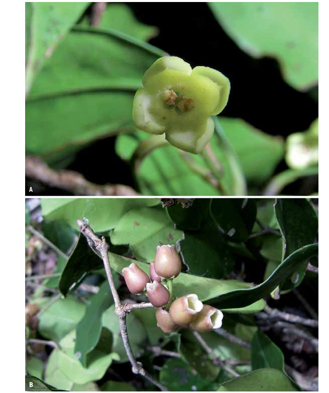
7. Noronhia brevituba H. Perrier View in CoL View at ENA in Mém. Inst. Sci. Madagascar, Sér. B, Biol. Vég. 2: 290. 1949 ( Fig. 6A View Fig ).
Typus: M ADAGASCAR. Prov. Toamasina: Forêt d’Analamazaotra , [18°55’48”S 48°25’48”E] GoogleMaps , II.1912, Perrier de la Bâthie 8820 (holo-: P [ P00573414 ]!; iso-: K [ K000233197 ] image seen, P [ P00573415 , P00573416 ]!) .
= Noronhia ambrensis H. Perrier View in CoL in Mém. Inst. Sci. Madagascar, Sér. B, Biol. Vég. 2: 297. 1949 GoogleMaps . Lectotypus (designated here): MADAGASCAR. Prov. Antsiranana: Ouest (Nord): camp d’Ambre GoogleMaps , [12°30’S 49°14’E], 900 m, XI.1932, Perrier de la Bâthie 18839 (P [ P00418074 ]!).
Description
Trees to 11 m tall, trunk to 15 cm diameter; young twigs cylindrical, 0.6-1.5 mm diameter, glabrous; bark medium to light gray, smooth, with scattered lenticels. Leaves opposite, persistent; bud scales rarely persistent; blades dark green above, lighter below, elliptic to obovate, 3-7.5 3 1.4-4.1 cm, chartaceous, glabrous, domatia absent, base acute to attenuate, margin flat to slightly undulate, apex cuspidate, the cusp 3-19 mm long, midrib flat above, raised below, secondary veins conspicuous mostly below, 5-10 per side, 5-16 mm apart, looping 1-4.5 mm from the margin; petiole yellow, 3-10 3 0.6-1.8 mm, not woody, glabrous. Thyrses fasciculate, pauciflorous, diffuse; peduncle 5-15 mm long, glabrous; pedicel 6-30 mm long, glabrous; calyx glabrous on both sides, lobes triangular, 1-1.5 3 0.7-2 mm; corolla yellow to pale lime green, sometimes tinged orange-brown with age, campanulate to subrotate, 3.5-7.5 mm long, glabrous on both sides, the tube 0.5-2.5 mm long, lobes ovate, apex slightly acute; corona present, 1-2 mm long, undivided; stamens 1.4-3 mm long, anthers widely oblong to almost square, 0.9-1.8 mm long; pistil 1.4-2.3 mm long, stigma capitate. Fruiting pedicel 3-19 3 0.5-1.7 mm; young fruits green, dark red when mature ovoid, 13-16.5 3 8-13 mm, surface smooth, apex flat to apiculate; dry pericarp 0.2-0.6 mm thick; endocarp woody; seed 9-12 3 5-7.5 mm.
Distribution, ecology and phenology
Noronhia brevituba occurs in mid- to high-elevation humid forests from Montagne d’Ambre in the north to Ranomafana in the south ( Fig. 3 View Fig ). It produces flowers and fruits from September to May.
Conservation status
The assessment was based on 28 collections representing 26 localities and yielded an EOO of 133,270 km 2, an AOO of 92 km 2, and 20 subpopulations representing 15 locations, of which 10 occur within protected areas (Analamazaotra, Anjanaharibe-Sud, Corridor Marojejy, Loky-Manambato, Makira, Manongarivo, Masoala, Montagne d’Ambre, Ranomafana, and Zahamena). Given these results and the likelihood that the AOO is much greater than the estimated 2,000 km 2, N. brevituba is assigned a preliminary status of “Least Concern”.
54 Boissiera 70
Notes
As currently circumscribed, Noronhia brevituba can be recognized by its non-woody petioles, chartaceous leaf blades and short-tubed, yellowish corolla. It mainly differs from N. linocerioides H. Perrier by its cuspidate (vs. acuminate) leaves, campanulate (vs. subrotate) flowers, capitate (vs. bilobed) stigma and apiculate (vs. bluntly pointed to rostellate) fruits. These two species belong to the same clade and form a complex (HONG- WA & BESNARD, 2013, 2014), for which additional information (e.g. anatomical data) and broader molecular sampling (e.g. individuals from each population across their range) may be required to disentangle their patterns of variation and relationships.
PERRIER DE LA BâTHIE (1949, 1952) distinguished Noronhia ambrensis H. Perrier from N. brevituba based mainly on the length of the corolla tube, placing the first in the section Noronhiae and the latter in section Linoceriae. However, their range of morphological variation overlaps and material assignable to these two entities is interspersed within a single clade (HONG- WA & BESNARD, 2014), which precludes the recognition of two species. It should be noted that the accessions labeled as N. ambrensis on the phylogenetic tree of HONG- WA & BESNARD (2014) were incorrectly assigned a homonym, whose nomenclature is addressed later in this treatment under N. olearia Hong-Wa. Specimens assigned to N. ambrensis by PERRIER DE LA BâTHIE (1949) were labeled as N. brevituba in the phylogenetic tree. Perrier de la Bâthie 18839 is chosen as the lectotype of N. ambrensis because it represents more complete material than the other syntype (Richard 192), which should be considered as an excluded syntype and is assigned to N. olearia (see p. 95).
Additional specimens examined
MADAGASCAR. Prov. Antananarivo: Andranofeno-Sud , forêt d’Ankafobe, 18°06’11”S 47°11’10”E, 1480 m, 14.XII.1999, Lowry et al. 5166 ( MO, P); GoogleMaps Anjozorobe , forêt de Saridrivotra, 18°16’S 47°54’E, 1570 m, 26.XII.2003, Randrianaivo et al. 1005 ( CNARP, MO, P, TAN); GoogleMaps Tampoketsa d’Ankazobe, forêt d’Antokomaro au PK 166/500 de la route de Majunga (au NO de Manerinerina), [17°57’S 47°07’E], 23.XII.1964, Service Forestier 24004 ( G, MO, P, TEF). GoogleMaps Prov. Antsiranana: Anjanaharibe-Sud RS, 10 km SW of Befingotra, 14°45’S 49°29’E, 1100-1300 m, 7.IX.1997, Birkinshaw et al. 487 ( G, MO, P, TAN); GoogleMaps Montagne d’Ambre PN, 12°32’19”S 49°09’32”E, 1219 m, 23.I.2009, Hong-Wa 579 ( G, MO, P, TAN); GoogleMaps Daraina, forêt d’Antsahabe , 13°12’37”S 49°33’27”E, 900 m, 17.I.2004, Nusbaumer 1023 (Daraina, G, K, MO, P, TEF); GoogleMaps Manongarivo RS, Antsatrotro , 14°04’S 48°17’E, 1700-1846 m, 9-10.V.1993, Rakotomalaza et al. 79 ( G, K, MO, P). GoogleMaps Prov. Fianarantsoa: Ranomafana PN, 21°15’S 47°27’E, 1100 m, 11-15.XI.1991, Malcomber et al. 1060 ( MO, P, TAN). GoogleMaps Prov. Mahajanga: Befandriana Nord , Matsoandakana , Andranomena , 15°08’02”S 49°20’49”E, 1134 m, 12.II.2008, Bernard 789 ( G, MO, P, TAN). GoogleMaps Prov. Toamasina: Forêt au N de la route de Nickelville , 850 m, 29.XII.1994, Cours 2089, ( P); GoogleMaps Analamazaotra RS, 18°56’07”S 48°25’06”E, 910 m, 2.V.2010, Hong-Wa & Ortiz 638 ( MO, P, TAN); GoogleMaps Manakambahiny Est, Zahamena RNI, 17°40’34”S 48°45’31”E, 1100 m, 17.IX.2002, Rakotondrajaona et al. 233 ( CNARP, MO, P, TEF); GoogleMaps Ambatondradama (env. 10 km au NE d’Ankovona ), Navana , 15°17’15”S, 50°01’07”E, 500 m, 1-6.X.1997, Ralimanana et al. 115 ( G, K, MO, P, TAN); GoogleMaps Ambatondrazaka, Antanandava , Antenina , 17°30’09”S 48°46’19”E, 917 m, 1.II.2002, Randrianjanaka 697 ( CNARP, G, MO, P, TEF). GoogleMaps

| CNARP |
CNARP |
| TEF |
TEF |
| M |
Botanische Staatssammlung München |
| P |
Museum National d' Histoire Naturelle, Paris (MNHN) - Vascular Plants |
| K |
Royal Botanic Gardens |
| MO |
Missouri Botanical Garden |
| TAN |
Parc de Tsimbazaza |
| G |
Conservatoire et Jardin botaniques de la Ville de Genève |
| TEF |
Centre National de la Recherche Appliquée au Developement Rural |
No known copyright restrictions apply. See Agosti, D., Egloff, W., 2009. Taxonomic information exchange and copyright: the Plazi approach. BMC Research Notes 2009, 2:53 for further explanation.
|
Kingdom |
|
|
Phylum |
|
|
Class |
|
|
Order |
|
|
Family |
|
|
Genus |
Noronhia brevituba H. Perrier
| Hong-Wa, Cynthia 2016 |
Noronhia ambrensis
| H. Perrier 1949: 297 |