
Noronhia candicans H. Perrier
|
publication ID |
https://doi.org/ 10.5281/zenodo.7599432 |
|
DOI |
https://doi.org/10.5281/zenodo.7591172 |
|
persistent identifier |
https://treatment.plazi.org/id/824F8D54-FF9A-3A28-FE28-FEE6FC0BF954 |
|
treatment provided by |
Carolina |
|
scientific name |
Noronhia candicans H. Perrier |
| status |
|
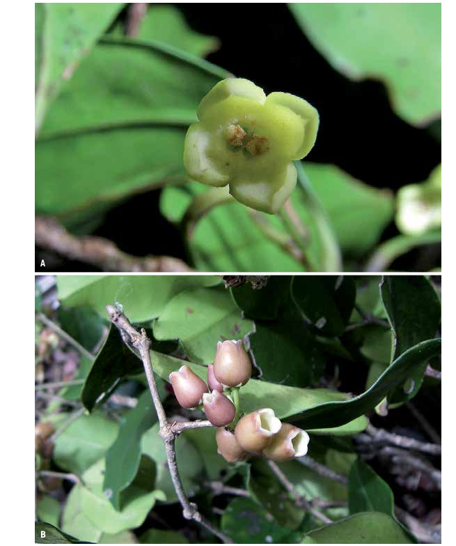
10. Noronhia candicans H. Perrier View in CoL View at ENA in Mém. Inst. Sci. Madagascar, Sér. B, Biol. Vég. 2: 301. 1949 ( Fig. 6B View Fig ).
Lectotypus (designated here): MADAGASCAR. Prov. Mahajanga: Bassin moyen du Bemarivo (Boina), [15°27’S 47°40’E], IX.1902, Perrier de la Bâthie 8829 ( P [ P00418071 ]!; GoogleMaps isolecto-: P [ P00418072 ]!) GoogleMaps . Syntypus: Bassin moyen du Bemarivo (Boina), [15°27’S 47°40’E], 500 m, IX.1902, Perrier de la Bâthie 8828 ( P [ P00418073 ]!) GoogleMaps .
Description
Shrubs to small trees to 5 m tall, trunk to 10 cm diameter; young twigs cylindrical, 0.7-1.8 mm diameter, glabrous; bark medium gray, smooth to slightly rugose. Leaves opposite, persistent; bud scales persistent; blades dark green above, lighter below, oblong to broadly elliptic, 4-12 3 1.6-5.2 cm, very coriaceous, glabrous, domatia absent, base acute to truncate, margin flat to slightly undulate, apex acute to acuminate, the acumen 1-16 mm long, midrib sunken above, distinctly raised below, secondary veins barely visible, 7-12 per side, 5-15 mm apart, looping 1-6 mm from the margin; petiole medium to light gray, 3-10 3 1.1-2.7 mm, entirely woody, glabrous. Flowers fasciculate; pedicel 3-20 mm long, sparsely pubescent; calyx sparsely pubescent outside, glabrous inside, lobes triangular, 2-2.6 3 1.5-2 mm; corolla purplish brown, urceolate, 4.5-7 mm long, glabrous on both sides, the tube 3-5 mm long, lobes widely ovate, apex obtuse; corona present, 1.2-1.7 mm long, undivided; stamens 1.8-2 mm long, anthers oblong, 1.3-1.8 mm long; pistil 2.2-2.5 mm long, stigma capitate. Fruiting pedicel 4-25 3 1-1.5 mm; young fruits green, reddish when mature, ovoid, 10-17.5 3 6-10 mm, surface smooth, apex apiculate to rostellate, the rostellum flattened, rounded, style persistent; dry pericarp 0.3-1.3 mm thick; endocarp woody; seed 7.5-10.5 3 5-6 mm.
Distribution, ecology and phenology
Noronhia candicans occurs in low- to mid-elevation dry forests from Montagne des Français and Daraina in the north to Sofia in the west ( Fig. 3 View Fig ). It produces flowers and fruits from September to March.
Conservation status
There were 28 collections representing 21 localities available for analysis, which resulted in an EOO of 27,250 km 2, an AOO of 68 km 2, and 14 subpopulations representing 10 locations, of which seven occur within protected areas (Andavakoera-Andrafiamena-Ambohipiraka, Ankarana, Loky-Manambato, and Montagne d’Ambre). The actual AOO is likely larger but would not exceed 2,000 km 2. In addition, the locations that are not encompassed within protected areas are affected by fire, land conversion, and illegal and/or artisanal mining resulting in habitat degradation and loss and reduction in the number of mature individuals. Therefore, N. candicans is assigned a preliminary status of “Vulnerable” [VU B1ab(i,ii,iii,iv,v)+2ab (i,ii,iii,iv,v)].
Notes
Noronhia candicans can be recognized by its very coriaceous, oblong to elliptic leaf blades, with barely visible venation and its fasciculate, purplish-brown flowers. It differs from N. crassinodis H. Perrier by its oblong to elliptic (vs. ovate) leaf blades with an acute to acuminate (vs. mucronulate) apex, barely visible (vs. conspicuous) venation, and purplish brown (vs. reddish) flowers. This species was described based on two syntypes, Perrier de la Bâthie 8828 and 8829, of which a specimen of the latter was chosen as the lectotype as it has more reproductive organs.
Additional specimens examined
MADAGASCAR. Prov. Antsiranana: Ankarana RS, 12°54’43”S 49°06’39”E, 180 m, 19. II.1994, Andrianarisata 45 ( MO, P) GoogleMaps ; ibid. loc., 12°54’36”S 49°06’25”E, 130 m, 16.X.1997, Bardot-Vaucoulon 775 ( K, MO, P, TAN) GoogleMaps ; ibid. loc., tsingy close to Campement des Anglais , 12°50’47”S 49°06’18”E, 82 m, 25. V.1999, De Block 1013 ( BR, MO, P, TAN) GoogleMaps ; ibid. loc., from Campement des Anglais towards Campement des Américains , 12°50’47”S 49°06’18”E, 82 m, 13. I.2002, De Block 1193 ( BR, G, MO, P, TAN) GoogleMaps ; Andrafiamena, Anjahankely , 12°55’00”S 49°20’25”E, 390 m, 27.XII.2010, Burivalova et al. 140 ( G, MO) GoogleMaps ; Daraina, forêt d’Antsahabe , 13°12’58”S 49°32’55”E, 830 m, 4.XII.2004, Gautier 4825 (Daraina, G, K, MO, TEF) GoogleMaps ; Andrafiamena, Anjahankely , 12°54’46”S 49°19’37”E, 410 m, 10.XI.2010, Gautier & Ranirison 5382 ( G, MO) GoogleMaps ; Marivorahona, Betsimiranja , 12°56’27”S 49°07’21”E, 136 m, 18. I.2009, Hong-Wa 566 ( MO, P, TAN) GoogleMaps ; Sakaramy, Montagne d’Ambre PN, 12°26’41”S 49°13’45”E, 367 m, 30. V.2010, Hong-Wa 699 ( MO, P, TAN) GoogleMaps ; Andrafiabe, Mont Antsahabe , 12°54’50”S 49°19’41”E, 408 m, 3.VII.2010, Hong-Wa 723 ( MO, TAN) GoogleMaps ; Ankarana RS, near Campement des Anglais , 12°54’42”S 49°06’42”E, 240-260 m, 22. V.1993, Jongkind & Rapanarivo 964 ( MO, P, TAN) GoogleMaps ; Tanambao-Marivorahona , 13°02’54”S 49°09’30”E, 154 m, 4.VII.2005, Leopold et al. 119 ( CNARP, G, MO, P, TAN) GoogleMaps ; Daraina, forêt de Bekaraoka , 13°06’32”S 49°42’28”E, 216 m, 12. II.2004, Nusbaumer & Ranirison 1154 (Daraina, G, K, MO, TEF) GoogleMaps ; ibid. loc., Andranovaka, Ankijomantsina , 13°07’56”S 49°28’20”E, 75 m, 29.X.2005, Rakotonandrasana et al. 946 ( CNARP, G, MO, P, TAN) GoogleMaps ; ibid. loc., forêt de Binara, 13°14’14”S 49°37’19”E, 310 m, 28.III.2004, Ranirison 506 (Daraina, G, K, MO, P, TEF) GoogleMaps ; ibid. loc., forêt d’Ambohitsitondroina , 13°07’56”S 49°28’08”E, 165 m, 7. I.2006, Ranirison & Nusbaumer 1057 (Daraina, G, K, MO, TEF) GoogleMaps ; ibid. loc., 13°08’19”S 49°27’58”E, 200 m, 8. I.2006, Ranirison & Nusbaumer 1066 (Daraina, G, K, MO, P, TEF) GoogleMaps ; Analabe , [14°03’S 49°43’E], 200 m, 13.IX.1955, Service Forestier 15497 ( TEF) GoogleMaps . Prov. Mahajanga: Antsohihy, Antonibe , Anjajavy , 15°01’26”S 47°15’34”E, 24 m, 19.VIII.2007, Rasoafaranaivo et al. 251 ( MO, P, TAN) GoogleMaps .

| P |
Museum National d' Histoire Naturelle, Paris (MNHN) - Vascular Plants |
| MO |
Missouri Botanical Garden |
| K |
Royal Botanic Gardens |
| TAN |
Parc de Tsimbazaza |
| V |
Royal British Columbia Museum - Herbarium |
| BR |
Embrapa Agrobiology Diazothrophic Microbial Culture Collection |
| I |
"Alexandru Ioan Cuza" University |
| G |
Conservatoire et Jardin botaniques de la Ville de Genève |
| TEF |
Centre National de la Recherche Appliquée au Developement Rural |
No known copyright restrictions apply. See Agosti, D., Egloff, W., 2009. Taxonomic information exchange and copyright: the Plazi approach. BMC Research Notes 2009, 2:53 for further explanation.
|
Kingdom |
|
|
Phylum |
|
|
Class |
|
|
Order |
|
|
Family |
|
|
Genus |
Noronhia candicans H. Perrier
| Hong-Wa, Cynthia 2016 |