
Noronhia gracilipes H. Perrier
|
publication ID |
https://doi.org/ 10.5281/zenodo.7599432 |
|
DOI |
https://doi.org/10.5281/zenodo.7586756 |
|
persistent identifier |
https://treatment.plazi.org/id/824F8D54-FFD5-3A61-FE28-FEE6FD7AFB15 |
|
treatment provided by |
Carolina |
|
scientific name |
Noronhia gracilipes H. Perrier |
| status |
|
30. Noronhia gracilipes H. Perrier View in CoL View at ENA in Mém. Inst. Sci. Madagascar, Sér. B, Biol. Vég. 2: 287. 1949 ( Fig. 22B View Fig ).
Typus: M ADAGASCAR. Prov. Toamasina: env. d’Analamazaotra , [18°55’48”S 48°25’48”E], 700 m, s.d., Perrier de la Bâthie 8811 (holo-: P [P00413233]!; iso-: P [P00413234]!). GoogleMaps
Description
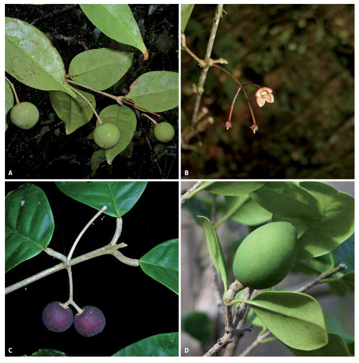
Trees to 10 m tall, trunk to 15 cm diameter; young twigs cylindrical, 0.5-1.5 mm diameter, glabrous; bark light gray to whitish, smooth, sometimes lenticellate. Leaves opposite, persistent; bud scales persistent; blades dark green above, lighter below, lanceolate to elliptic, 5.5-11.5 3 2-4.6 cm, chartaceous, glabrous, domatia casual to common, base acute to attenuate, margin slightly revolute and undulate, apex acuminate to cuspidate, the acumen or cusp 6-23 mm long, midrib slightly sunken above, raised below, secondary veins conspicuous, 5-10 per side, 6-26 mm apart, looping 1-5 mm from the margin; petiole light gray to whitish, 2-9 3 0.7-2.2 mm, entirely woody, glabrous. Thyrses fasciculate, pauciflorous, diffuse; peduncle 2-22 mm long, glabrescent; pedicel 14-36 mm long, glabrescent; calyx sparsely pubescent outside, glabrous inside, lobes triangular to deltate, 1.5-3 3 1-2 mm; corolla pinkish, cupuliform to subrotate, 4-6 mm long, glabrous on both sides, the tube 1.5-4 mm long, lobes lanceolate, apex acute; corona absent; stamens 1.5-2.7 mm long, anthers oblate to orbicular, 1.3-1.9 mm long; pistil 2.2-3.8 mm long, stigma capitate. Fruiting pedicel 10-37 3 0.5-2.3 mm; young fruits green, dark red when mature, subglobose, 13-24 3 12.5-22 mm, surface smooth, sometimes covered with white dots, apex apiculate; dry pericarp 0.3-1.1 mm thick; endocarp crustaceous; seed 9-19.5 3 7-15 mm.
Distribution, ecology and phenology
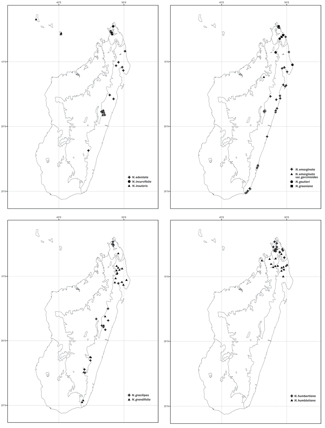
Noronhia gracilipes occurs in low- to high-elevation humid forests from Montagne d’Ambre in the north to Ranomafana in the south ( Fig. 19 View Fig ). It produces flowers and fruits throughout the year except in March and April.
Conservation status
Based on 34 collections representing 28 localities, the assessment indicated an EOO of 86,638 km 2, an AOO of 100 km 2, and 15 subpopulations representing 12 locations, of which seven occur within protected areas (Ambalabe, Analamazaotra, Andringitra, Corridor Ankeniheny-Zahamena, Montagne d’Ambre, Pic d’Ivohibe, and Zahamena). With such a large EOO and presence in many protected areas, N. gracilipes is assigned a preliminary status of “Least Concern”.
Notes
Noronhia gracilipes can be recognized by its chartaceous, acuminate leaf blades, long peduncles and pedicels, pinkish flowers, and subglobose, crustaceous fruits. This species closely resembles N. decaryana , from which it differs mainly by the color of its bark (whitish vs. gray) and flowers (pinkish vs. orangish-red), and by the shape of its corolla (cupuliform to subrotate vs. urceolate).
116 Boissiera 70
Additional specimens examined
MADAGASCAR. Prov. Antananarivo: Andreba, au voisinage d’Anjozorobe , [18°18’S 47°52’E], 1400-1500 m, 1.XI.1967, Bernardi 11135 ( G, P). GoogleMaps Prov. Antsiranana: Montagne d’Ambre ( Station des Roussettes ), 12°33’S 49°08’E, 1000 m, 22.I.2009, Hong-Wa 571 ( MO, P, TAN); GoogleMaps Antsalaka, Montagne d’Ambre PN, 12°37’17’’S 49°10’46’’E, 1038 m, 12.VI.2010, Hong-Wa 713 ( MO, P, TAN); GoogleMaps ibid. loc., 12°34’49”S 49°07’58”E, 20.I.2008, Ramandimbimanana et al. 38 ( G, MO, TEF); GoogleMaps ibid. loc., 12°36’11”S 49°11’28”E, 1030 m, 1.V.2008, Ramandimbimanana 104 ( G, MO, TEF); GoogleMaps ibid. loc., 12°30’49”S 49°09’51”E, 1040 m, 24.V.2008, Ramandimbimanana et al. 128 ( G, MO, TEF); GoogleMaps Ambohitra (Joffreville), Montagne d’Ambre PN, 12°33’S 49°08’E, 1000 m, 13.IX.1987, Schatz 1504 ( G, MO, P, TAN); GoogleMaps ibid. loc., 12°36’12”S 49°11’55”E, 910 m, 5.V.2008, Trigui et al. 335 ( G, MO, TEF). GoogleMaps Prov. Fianarantsoa: Andringitra RNI, Camp II, c. 43 km S of Ambalavao , 22°13’22’’S 46°58’18’’E, 1210 m, 1-7.XII.1993, Lewis et al. 1011 ( MO, P); GoogleMaps Ivohibe RS, 22°29’00’’S 46°58’06’’E, 1200 m, 16.X.1997, Rakotomalaza et al. 1431 ( G, MO, P, TAN); GoogleMaps Andrambovato, Fort-Carnot , [21°31’S 47°25’E], 878-1000 m, 24.VIII.1955, Service Forestier 15400 ( MO, TEF). GoogleMaps Prov. Toamasina: Brickaville, Ambodilendemy , Ankerana , 18°25’40”S 48°47’17”E, 990 m, 24.III.2011, Antilahimena 7782 ( G, MO, P, TAN); GoogleMaps Andasibe-Périnet , 18°56’S 48°25’E, 1000 m, 2-5.XI.1984, Dorr & Barnett 3183 ( MO, P, TAN); GoogleMaps Analamazaotra RS, 18°56’S 48°26’E, 9.VI.1938, Herb. Jard. Bot. Tan. 3731 ( MO); GoogleMaps Ambatondrazaka, Antanandava, Antenina , 17°30’09”S 48°46’19”E, 917 m, 1.II.2002, Randrianjanaka 696 ( CNARP, G, MO, P, TEF); GoogleMaps Vatomandry, Ambalabe, Ambinanindrano II, 19°09’47”S 48°34’37”E, 624 m, 12.VIII.2006, Razanatsima 147 ( MO, P, TAN); GoogleMaps Ambodiriana , 17°53’24”S 49°13’48”E, 29.XI.1953, Réserves Naturelles 5907 ( MO) GoogleMaps .
| TEF |
TEF |
| CNARP |
CNARP |
| M |
Botanische Staatssammlung München |
| G |
Conservatoire et Jardin botaniques de la Ville de Genève |
| P |
Museum National d' Histoire Naturelle, Paris (MNHN) - Vascular Plants |
| MO |
Missouri Botanical Garden |
| TAN |
Parc de Tsimbazaza |
| TEF |
Centre National de la Recherche Appliquée au Developement Rural |
No known copyright restrictions apply. See Agosti, D., Egloff, W., 2009. Taxonomic information exchange and copyright: the Plazi approach. BMC Research Notes 2009, 2:53 for further explanation.
|
Kingdom |
|
|
Phylum |
|
|
Class |
|
|
Order |
|
|
Family |
|
|
Genus |