
Paraperla frontalis (Banks)
|
publication ID |
https://doi.org/10.5281/zenodo.4758256 |
|
publication LSID |
lsid:zoobank.org:pub:AF38044D-2A5E-47E4-9A66-DDA55D033156 |
|
DOI |
https://doi.org/10.5281/zenodo.4765386 |
|
persistent identifier |
https://treatment.plazi.org/id/826787E3-621D-9842-D6B9-46BA2F13F9D5 |
|
treatment provided by |
Felipe |
|
scientific name |
Paraperla frontalis (Banks) |
| status |
|
Paraperla frontalis (Banks) View in CoL
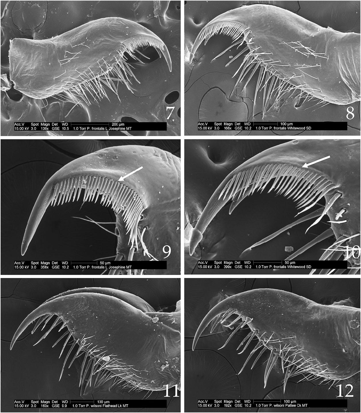
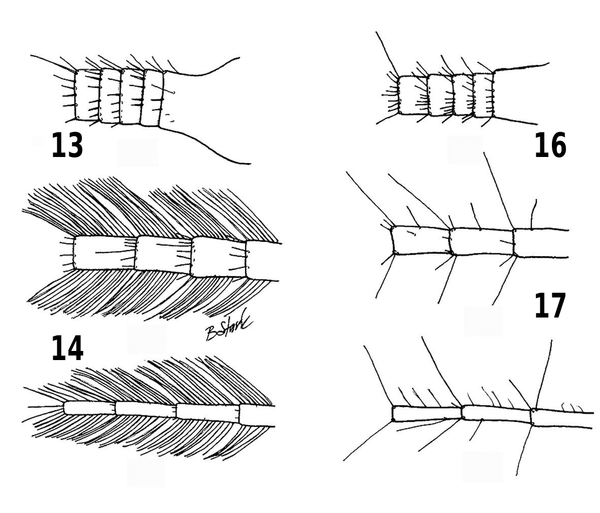
( Figs. 1-4 View Figs , 7-10 View Figs , 13-15 View Figs )
Perlinella frontalis Banks 1902:123 .
Holotype ♂ ( Museum of Comparative Zoology), Beulah , [ San Miguel Co., Sapello Canyon] New Mexico
Paraperla frontalis: Claassen, 1931:65 View in CoL . Larval description Paraperla frontalis: Ricker, 1965:498 View in CoL . Geographic variation of epiproct
Paraperla frontalis: Baumann et al., 1977 View in CoL . Head, pronotum, ♂, ♀ terminalia
Paraperla frontalis: Zwick, 2006:21 View in CoL . Description of lacinial pecten
Material examined. (Suitable egg and/or larval/ exuvial specimens were examined from the following sites): CANADA: YUKON: Bearfield Creek, Hwy 4, 62 ° 11’ 15.03”N, 135 ° 05’ 20.43”W, 25 June 1996, J.C. Abbott, K.W. Stewart, 1 exuvium ( KWSC) GoogleMaps . UNITED STATES: ALASKA: West Fork Chena River GoogleMaps , below Chena Hot Springs, 2 July 1980, K.S. Stewart, Howe, 1♀ (no eggs), 11 exuvia ( KWSC) . North Fork Chena River GoogleMaps , Chena Hot Springs Road, 19 July 1986, K.W. Stewart, M. Oswood, 26 exuvia ( KWSC) . Nations River GoogleMaps @ Yukon River GoogleMaps jct, near Eagle, 9 July 1982, R. West, 1 larva ( KWSC) . CALIFORNIA: Alpine Co., West Carson River GoogleMaps , Blue Lakes Rd GoogleMaps , 27 July 1995, R. Bottorff, 1♀ ( BPSC) . Humboldt Co. GoogleMaps , Grassy Creek GoogleMaps , Fieldbrook GoogleMaps , 22 May 1982, B. Stark, D. Ziegler, 1♀ ( BPSC) . Klamath River GoogleMaps , Hoopa Reservation GoogleMaps , Hwy GoogleMaps 96, 1 May 2011, B.C. Kondratieff, J. Sandberg, 5♂, 3♀, 3 exuviae ( CSUC) . Klamath River GoogleMaps , Aikens Creek Camp Ground GoogleMaps , Hwy GoogleMaps 96, 1 May 2011, B.C. Kondratieff, J. Sandberg, 1♂, 3♀ ( CSUC) . IDAHO: Lemhi Co. GoogleMaps , Wagonhammer Spring GoogleMaps , near North Fork GoogleMaps , 22 June 1969, B.R. Oblad, 3 larvae, 3 exuviae ( BYUC) . MONTANA: Flathead Co. GoogleMaps , Middle Fork Flathead River GoogleMaps , Nyack GoogleMaps flood plain, 14 June 2003, B. Reid, 10♂, 10♀ ( 1♀ with eggs) ( CSUC) . Glacier Co. GoogleMaps , Lake Josephine GoogleMaps , Glacier National Park GoogleMaps , 13 July 1964, A.R. Gaufin, larvae ( BYUC) . Lewis & Clark Co. GoogleMaps , Dearborn River GoogleMaps , 10 mi west continental divide, Hwy GoogleMaps 20, 24 June 1965, A.V. Nebeker, 1♀ ( BYUC) . Sweet Grass Co. GoogleMaps , American Creek GoogleMaps , 10 mi above Hwy 191, 30 June 1966, J.R. Grierson, 1♀ ( BYUC) . OREGON: Union Co. GoogleMaps , Jordan Creek GoogleMaps , 20 mi southwest of La Grande GoogleMaps , 30 July 1975, DFTM Project GoogleMaps , 1♀ ( BYUC) . SOUTH DAKOTA: Lawrence Co. GoogleMaps , Whitewood Creek GoogleMaps , Lead GoogleMaps , 18 March 1981, R.W. Baumann, R.N. Winget, larvae ( BYUC) . Pennington Co. GoogleMaps , Pine Creek GoogleMaps , Hwy GoogleMaps 244, 10 July 1997, R.W. Baumann, B.C. Kondratieff, 1♀ ( BYUC) . UTAH: Cache Co. GoogleMaps , Franklin Basin GoogleMaps , 3 July 1978, G.F. Knowlton, 1♀ ( BYUC) . Salt Lake Co. GoogleMaps , Thousand Springs GoogleMaps , Mill Creek Canyon GoogleMaps , 20 July 1982, R.W. Baumann, S. Clark, 1♀ ( BYUC) . Big Cottonwood Creek GoogleMaps , below Storm Mountain GoogleMaps , 9 June 1965, A.V. Nebeker, 2♀, 5 exuviae (no ♀ with eggs) ( BYUC) . WASHINGTON: Clallam Co. GoogleMaps , Dungeness River GoogleMaps , 15 June 2005, B.C. Kondratieff, R.W. Baumann, 1♂, 2♀, 4 exuviae (no ♀ with eggs) ( CSUC) . Skagit Co. GoogleMaps , tributary Skagit River GoogleMaps , South Skagit Hwy GoogleMaps , 0.5 mi west of Walberg Rd GoogleMaps , 15 April 1967, collector unidentified, 1♀ ( BYUC) . WYOMING: Fremont Co. GoogleMaps , Middle Popo Agie River GoogleMaps , The Sinks State Park GoogleMaps , 15 July 1986, R.W. Baumann, B.J. Sargent, 1 larva ( BYUC) . Teton Co. GoogleMaps , Snake River GoogleMaps , Rt GoogleMaps 22, 25 June 1995, B.C. Kondratieff, 17♂, 26♀, 9 exuviae ( 2 ♀ with eggs) ( CSUC) . Cottonwood Creek GoogleMaps , near Moose Entrance GoogleMaps , Grand Teton National Park GoogleMaps , 9 June 1987, B.C. Kondratieff, 6♂, 2♀, 14 exuviae (no ♀ with eggs) ( CSUC) . Additional specimens examined : UNITED STATES: ALASKA: Kwethluk River GoogleMaps , 16 July 2013, Z. Crete, 4♂, 1♀ ( CSUC) . CALIFORNIA: Alpine Co. GoogleMaps , West Carson River GoogleMaps , Blue Lake Rd GoogleMaps , 27 July 1995, R. Bottorff, 1♀ ( BPSC) . El Dorado Co. GoogleMaps , Sopiago Creek GoogleMaps , Hwy GoogleMaps 88, 3 May 1995, R.L. Bottorff, 1♀ ( BPSC) . South Fork American River GoogleMaps , Hwy GoogleMaps 49, Coloma GoogleMaps , 29 April 2010, B.C. Kondratieff, R.W. Baumann, 1♂, 1♀ ( CSUC) . Humboldt Co. GoogleMaps , Willow Creek GoogleMaps , Hwy GoogleMaps 299, jct East Fork Willow Creek GoogleMaps , 22 June 1985, R.W. Baumann, C.R. Nelson, M.F. Whiting, 1♀ ( BYUC) . East Fork Willow Creek GoogleMaps , Willow Creek Campground GoogleMaps , 24 April 1987, B. Stark, R.W. Baumann, C.R. Nelson, S. Wells, 2♀ ( BPSC) . Modoc Co. GoogleMaps , Rush Creek GoogleMaps , Upper Rush Creek Camp Ground GoogleMaps , 24 May 2007, B.C. Kondratieff, R.W. Baumann, 1♀ ( CSUC) . COLORADO: Archuleta Co. GoogleMaps , East Fork GoogleMaps , FR 667, 11 July 1998, B.C. Kondratieff, 1♀ ( CSUC) . Boulder Co. GoogleMaps , Middle St. Vrain Creek GoogleMaps , FR 114, 17 July 1993, B.C. Kondratieff, Painter GoogleMaps , 1♀ ( CSUC) . Chaffee Co. GoogleMaps , Middle Cottonwood Creek GoogleMaps , Cottonwood Pass Rd GoogleMaps , 10 July 2003, R.E. Zuellig, 1♀ ( CSUC) . Hinsdale Co. GoogleMaps , Hensen Creek GoogleMaps , 9 mi above lake, 14 July 1962, A. Knight, 1♂, 1♀ ( BYUC) . La Plata Co. GoogleMaps , Los Pinos River GoogleMaps , Rt GoogleMaps 160, Bayfield GoogleMaps , 9 July 1998, B.C. Kondratieff, 1♀ ( CSUC) . Larimer Co. GoogleMaps , Poudre River GoogleMaps , Hwy GoogleMaps 14 abv. Tunnel Creek GoogleMaps , 4 July 2013, C. Verdone, 1♀ ( CSUC) . Saguache Co. GoogleMaps , Mendano Creek GoogleMaps , Great Sand Dunes Preserve GoogleMaps , 23 June 2005, R.E. Zuellig, 1♂ ( CSUC) . Summit Co. GoogleMaps , Union Creek GoogleMaps , Copper Mountain GoogleMaps , 6 July 1997, B.C. Kondratieff, 1♂ ( CSUC) . MONTANA: Flathead Co. GoogleMaps , Logan Creek GoogleMaps , Logan Pass GoogleMaps , Glacier National Park GoogleMaps , 20-22 July 1979, B. Stark, K.W. Stewart, R.W. Baumann, 1♀ ( BPSC) . Gallatin Co. GoogleMaps , Gallatin River GoogleMaps , Bozeman GoogleMaps , 17 June 1987, D.L. Gustafson, 5♀ ( BPSC) . New World Gulch Creek GoogleMaps , Mount Ellis GoogleMaps , abv. trailhead, 14 June 2013, S. Fiance, 1♂ ( CSUC) . Lake Co. GoogleMaps , Ross Creek GoogleMaps , University GoogleMaps of Montana Biological Station GoogleMaps , Malaise trap, 19 June-10 July 1987, collector unidentified, 6♀ ( KWSC) . Ravalli Co. GoogleMaps , Bitterroot River GoogleMaps , River Park GoogleMaps , Hamilton GoogleMaps , 14 June 2006, R. Durfee, 3♂ ( CSUC) . Same GoogleMaps site, 22 June 2006, R. Durfee, 2♂, 2♀ ( CSUC) . Same GoogleMaps site, 1 July 2006, R. Durfee, 1♂, 2♀ ( CSUC) . Same GoogleMaps site, 15 July 2006, 1♂ ( CSUC) . NEW MEXICO: Lincoln Co. GoogleMaps , Rio Bonito GoogleMaps above Bonito Lake GoogleMaps , 29 May 1995, B. Stark, C. Massey, 2♀ ( BPSC) . OREGON: Clatsop Co. GoogleMaps , Big Creek GoogleMaps , 16 April 1949, S.G. Jewett, 4♂, 9♀ ( CASC) . Curry Co. GoogleMaps , Brush Creek GoogleMaps , Hwy GoogleMaps 101, Humbug Mountain State Park GoogleMaps , 9 June 2005, B.C. Kondratieff, R.W. Baumann, 1♂, 2♀ ( CSUC) . Hood River Co. GoogleMaps , Hermann Creek GoogleMaps , 2 April 1940, S.G. Jewett, Jr., 1♀ ( CASC) . Union Co. GoogleMaps , Velvet Creek GoogleMaps , ca. 8 mi east Medical Springs, DFTM Project GoogleMaps , 1♀ ( BYU) . UTAH: Uintah Co. GoogleMaps , Jones Creek GoogleMaps , Dinosaur National Monument GoogleMaps , 21 May 1988, C.E. Hunter, 1♀ ( CSUC) . Utah Co., Rock Canyon Creek GoogleMaps , Rock Canyon GoogleMaps , east of Provo GoogleMaps , 16 July 1979, A.T. Christenson, 1♀ ( BYUC) . WASHINGTON: Jefferson Co. GoogleMaps , Taft Creek GoogleMaps , 1 mi W Hoh Visitor Center, Olympic National Park GoogleMaps , 16 July 1979, B. Stark, 1♂ ( BPSC) . Skagit Co. GoogleMaps , Hansen Creek GoogleMaps , Hwy GoogleMaps 20, 2 mi east Sedro Wooley, 30 April 1967, collector unidentified, 1♂, 2♀ ( BYUC) . Yakima Co. GoogleMaps , Little Naches River GoogleMaps , 2 mi E American River, 11 June 1967, R.W. Baumann, 1♀ ( BYUC) . WYOMING: Johnson Co. GoogleMaps , West Fork Clear Creek GoogleMaps , Hwy GoogleMaps 16, 13 July 2010, B.C. Kondratieff, Mercado GoogleMaps , 1♀ ( CSUC) . Sublette Co. GoogleMaps , Green River GoogleMaps , Daniel GoogleMaps , 19 July 1972, B. Stark, 1♀ ( BPSC) . Pine Creek GoogleMaps , Pinedale GoogleMaps , 20 July 1972, B. Stark, 2♀ ( BPSC) .
Egg. Outline oval ( Fig. 1 View Figs ). Length ca. 305 μm, equatorial width ca. 227 μm. Collar sessile, surrounded by a smooth circular zone ca. 43 μm wide forming a circular plaque-like structure with diameter of ca. 107 μm ( Figs. 2, 3 View Figs ). Chorion covered throughout (except smooth collar zone) with irregularly sized pits; larger pits, ca. 6.5 μm in diameter, give a coarse aspect to chorionic surface. Micropylar row equatorial, orifices without rims ( Fig. 4 View Figs ).
Larva. Body length pre-emergent specimens 15-17 mm. General color pale brown without distinctive pigment pattern. Body covered with thin clothing hairs and short, thick setae, usually restricted to posterior segmental fringes and lateral clusters. Posterior fringes of abdominal sterna interrupted mesally except on sternum 10. Lacinia with two teeth, 2 nd much smaller than 1 st; and not reaching mid length of larger tooth ( Figs. 7-8 View Figs ); a prominent row of ca. 30 spine-like pecten comprise a comb-like structure extending from base of 1 st lacinial tooth, along midline of tooth to beyond base of 2 nd tooth ( Figs. 9-10 View Figs ). Basal cercal segments with terminal whorl of setae, but mid and apical segments bear a dense vertical fringe of long, fine swimming hairs ( Figs. 13-15 View Figs ).

| KWSC |
KWSC |
| BPSC |
BPSC |
| CSUC |
USA, Colorado, Fort Collins, Colorado State University |
| BYUC |
USA, Utah, Provo, Brigham Young University, Monte L. Bean Life Science Museum |
| CASC |
USA, California, San Francisco, California Academy of Sciences |
| BYU |
USA, Utah, Provo, Brigham Young University, Monte L. Bean Life Science Museum |
No known copyright restrictions apply. See Agosti, D., Egloff, W., 2009. Taxonomic information exchange and copyright: the Plazi approach. BMC Research Notes 2009, 2:53 for further explanation.
|
Kingdom |
|
|
Phylum |
|
|
Class |
|
|
Order |
|
|
Family |
|
|
Genus |
Paraperla frontalis (Banks)
| Stark, Bill P., Baumann, Richard W., Kondratieff, Boris C. & Stewart, Kenneth W. 2013 |
Paraperla frontalis :
| Zwick, P. 2006: 21 |
Paraperla frontalis :
| Ricker, W. E. 1965: 498 |
| Claassen, P. W. 1931: 65 |
Perlinella frontalis
| Banks, N. 1902: 123 |
Paraperla frontalis :
| Paraperla frontalis : Baumann et al., 1977 |