
Dubiaranea difficilis (Mello-Leitão 1944)
|
publication ID |
https://doi.org/10.11646/zootaxa.5437.2.3 |
|
publication LSID |
lsid:zoobank.org:pub:EDC6561B-0040-4CEF-AEB1-D23BCE9DCF52 |
|
DOI |
https://doi.org/10.5281/zenodo.10984581 |
|
persistent identifier |
https://treatment.plazi.org/id/8B6087D3-FFD1-263D-FF14-3AA6FCACF93A |
|
treatment provided by |
Plazi |
|
scientific name |
Dubiaranea difficilis (Mello-Leitão 1944) |
| status |
|
Dubiaranea difficilis (Mello-Leitão 1944) View in CoL
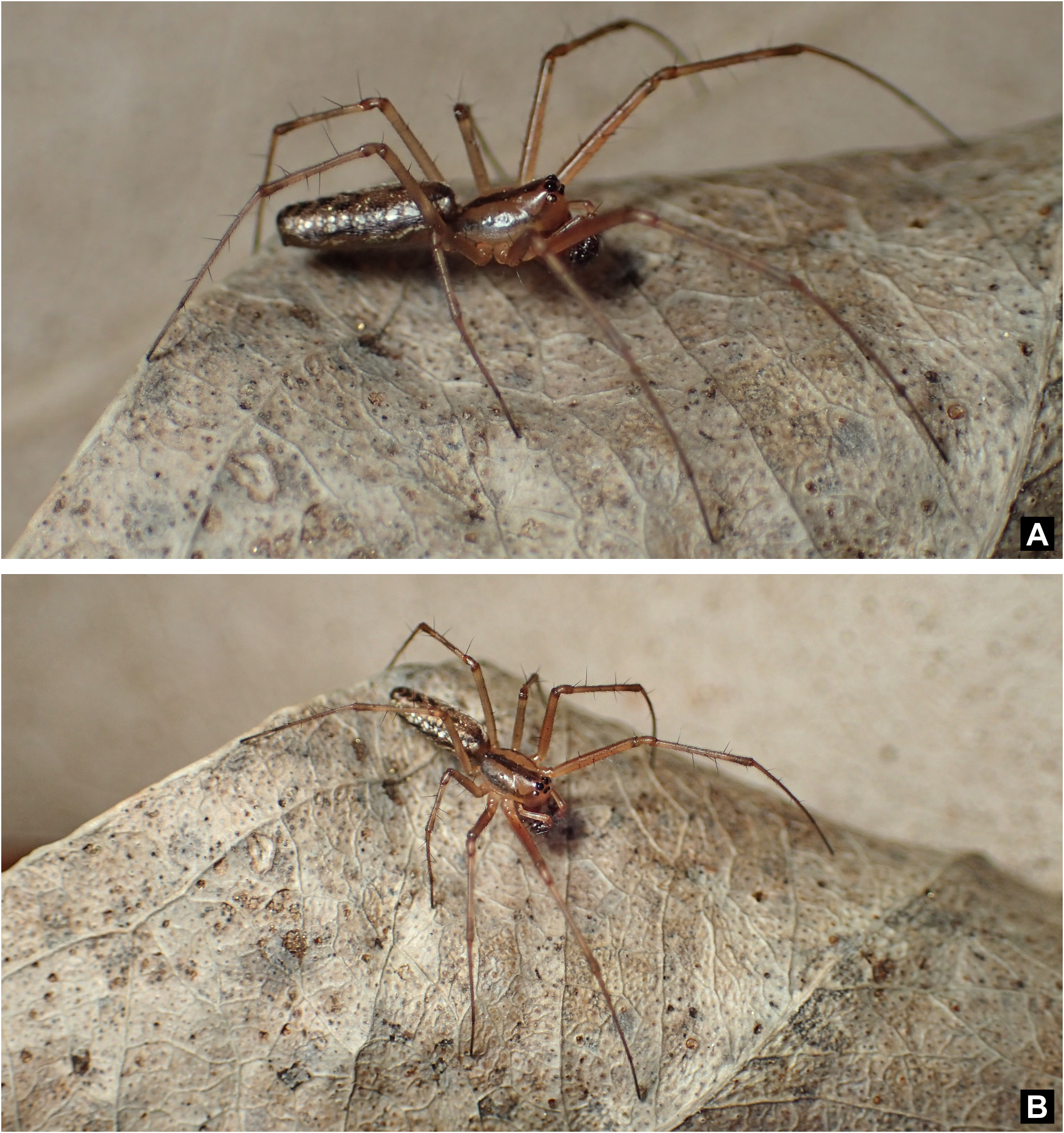
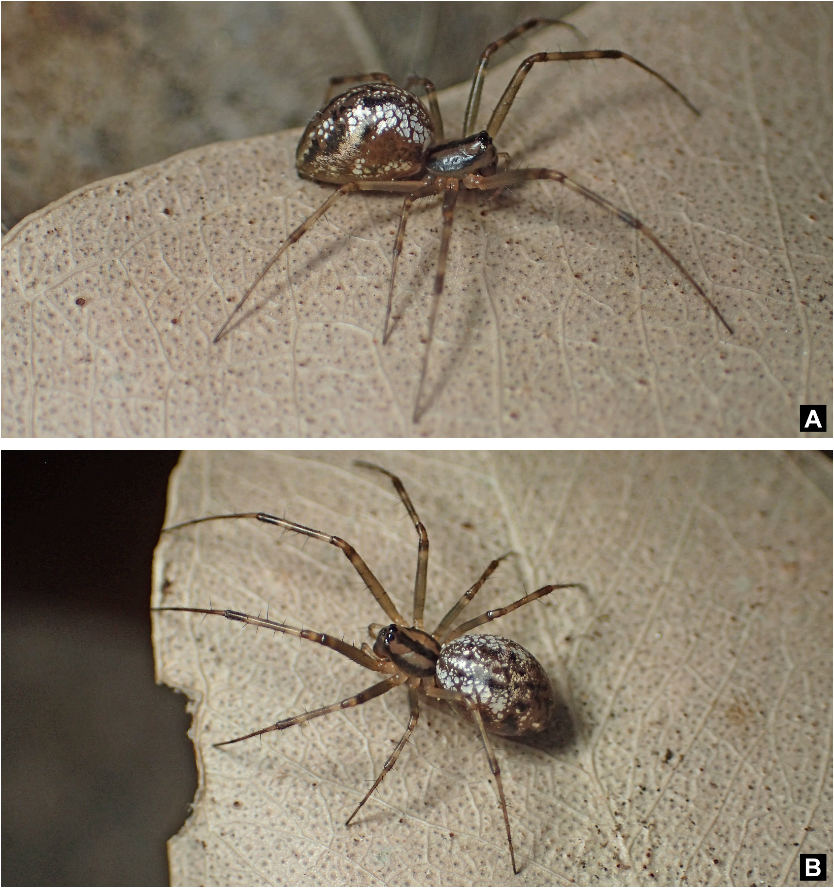
Figs 8–11 View FIGURE 8 View FIGURE 9 View FIGURE 10 View FIGURE 11
New records. URUGUAY. Maldonado, Sierra de Carapé ( 34°31’25”S, 54°58’30.34”W), 15.xi.2019, M. Simó & Á. Laborda coll., 1F (FCE-Ar 10903); GoogleMaps same data, 1F (FCE-Ar 10843) GoogleMaps . Río Negro, El Matorral ( 33°01’12.1”S, 57°33’59.7”W), 27.xi.2019, M. Simó & Á. Laborda coll., 1F (FCE-Ar 12740). GoogleMaps Ruta 24, km 85, Arroyo Negro, Estancia “Las Cadenas” ( 32°31’16.02”S, 58°2’7.03”W), GoogleMaps 12–16.iii.2018, D. Hagopián & A. Mailhos coll., 1F (FCEAr 13602) GoogleMaps . Durazno, Eucalyptus plantation, near La Paloma ( 32°32’40.52”S, 55°42’51.74”W), GoogleMaps 26.viii.2021, D. Hagopián & M. Cajade coll., 2F (FCE-Ar 10282); GoogleMaps same data, 1F (FCE-Ar 10374); ( 32°32’40.67”S, 55°42’43.55”W), 26.viii.2021, D. Hagopián coll. 1F (FCE-Ar 13546); GoogleMaps same data, 1F (FCE-Ar 13605) GoogleMaps . Rivera, Cerro Miriñaque ( 31°29’56.7”S, 55°38’59.9”W), 30.x.2010, M. Simó & Á. Laborda coll., 1M, 3F (FCE-Ar 4433). GoogleMaps Ruta 27, Arroyo Batoví ( 31°06’58.5”S, 55°24’57.4”W), 30.x.2010, M. Simó coll., 1F (FCE-Ar 4068) GoogleMaps .
Other records from GBIF. ARGENTINA. Buenos Aires. San Pedro. Parque Histórico Natural Vuelta de Obligado ( 33°35’53.89”S, 59°48’35.38”W). GoogleMaps 1F (MACN-Ar 36853), GoogleMaps 1F (MACN-Ar 36855), GoogleMaps 1F (MACN-Ar 36862), GoogleMaps 1F (MACN-Ar 36940), GoogleMaps 1F (MACN-Ar 36942). GoogleMaps San Isidro. Acassuso, Reserva Municipal Refugio Natural Educativo Ribera Norte ( 34°28’2.32”S, 58°29’37.21”W). GoogleMaps 1F (MACN-Ar 32035), GoogleMaps 1F (MACN-Ar 32424), GoogleMaps 1F (MACN-Ar 33063), GoogleMaps 1F (MACN-Ar 33325), GoogleMaps 1F (MACN-Ar 33471), GoogleMaps 1F (MACN-Ar 33563), GoogleMaps 1F (MACN-Ar 34711). GoogleMaps Reserva Ecológica Costanera Sur , CABA ( 34°36’16.7”S, 58°21’00.6”W), 11.xi.2021, L. Zapata, 1F (iNaturalist. https://inaturalist-open-data.s3.amazonaws.com/photos/169095457/original.jpg) GoogleMaps . Entre Ríos. Parque Nacional Predelta, sendero a Laguna Las Piedras ( 32°7’28.79”S, 60°37’39.65”W) 1F (MACN-Ar 28317) GoogleMaps . Jujuy. Ledesma. Parque Nacional Calilegua, Mesada de las Colmenas ( 23°39’54.06”S, 64°50’25.62”W). GoogleMaps 1M (MACN-Ar 27126), GoogleMaps 1M (MACN-Ar 27129), GoogleMaps 1M (MACN-Ar 27130). GoogleMaps Parque Nacional Calilegua, Alisal, km 21 Ruta Provincial Nº 83 ( 23°41’8.38”S, 64°53’2.61”W). GoogleMaps 1M (MACN-Ar 27130) GoogleMaps .
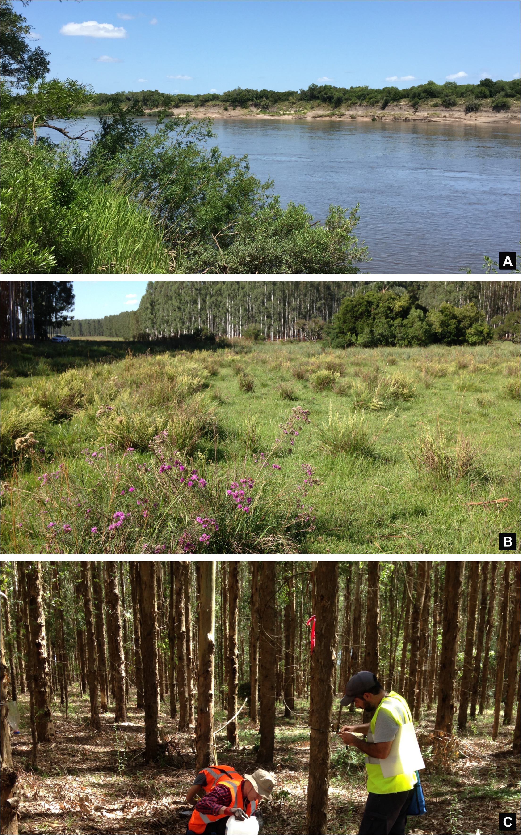
Natural history. In Uruguay, Dubiaranea difficilis ( Figs 8–9 View FIGURE 8 View FIGURE 9 ) was found in riparian native forests, hill native forests, grasslands and Eucalyptus dunnii Maiden forestry plantations (six and ten year old plantations) ( Fig. 10 View FIGURE 10 ). This species has already been found for riparian forests ( Laborda et al. 2018) and ravine forests ( Laborda et al. 2020) from this country. In the forests they spin their web between branches of the undergrowth, in the Eucalyptus plantations between fallen branches on the ground near the base of the trees, and in the grasslands between subshrub vegetation and erect herbs. The webs of the females can reach 25 cm in length, males were found in smaller webs close to the webs of the females.
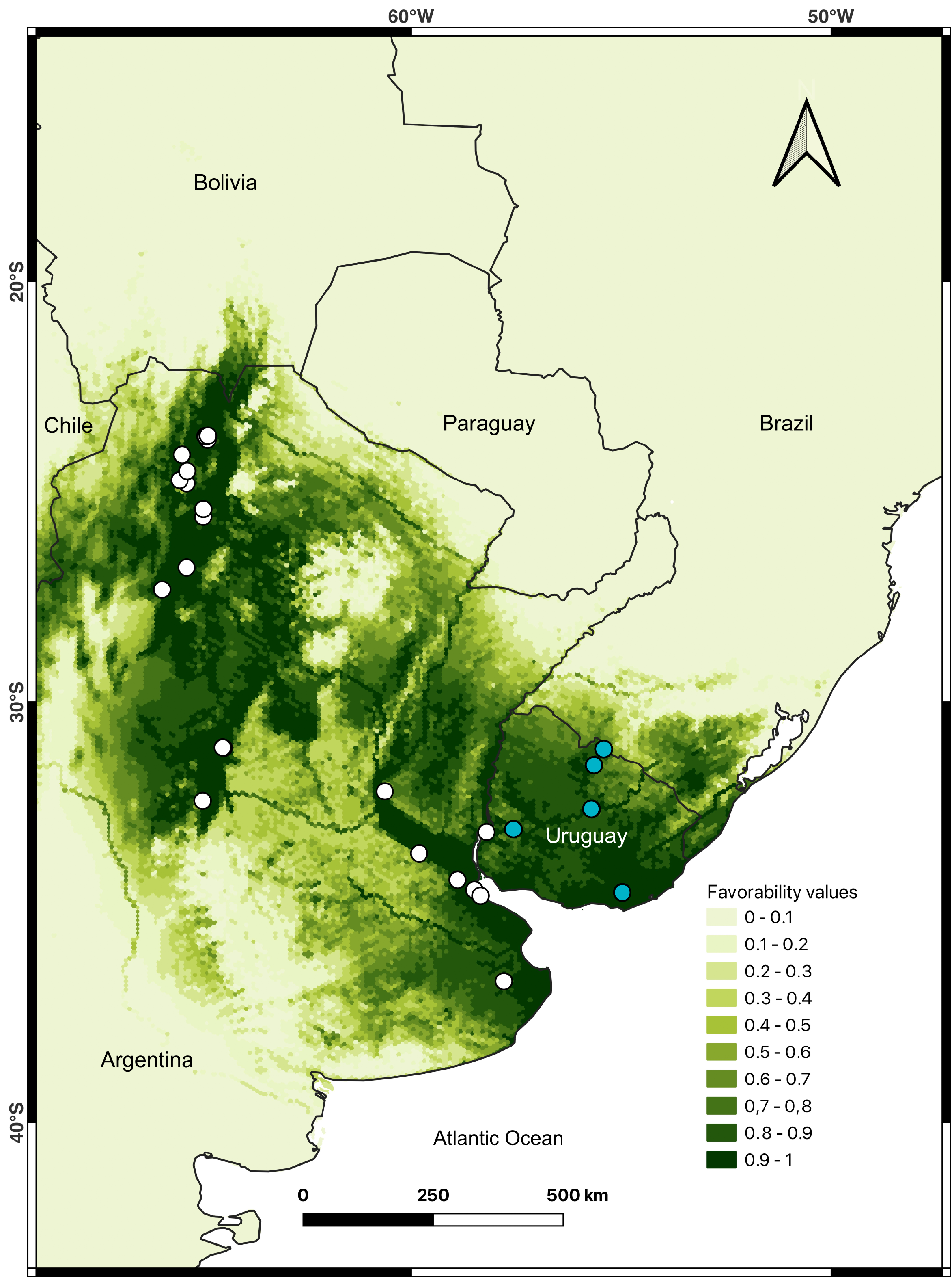
Distribution. Known for northern and Central Argentina and Uruguay ( Fig. 11 View FIGURE 11 ). The model shows favourable areas for the species in Bolivia and southern Brazil. Seven predictor variables were selected for the model distribution of the species. Tree cover (12.472), Spatial component (Wald: 14.461), Precipitation in the warmest quarter (BIO 18) (Wald: 7.890), Summatory of Big rivers (Wald: 8.381) and Seasonal temperatures (BIO 4) (Wald: 10.432) had a positive relationship. Contrary, Evapotranspiration Potential Annual (ETP Annual) (Wald: 18.315) and Crops (Wald: 4.150) showed a negative relationship ( Table 2 View TABLE 2 ).
No known copyright restrictions apply. See Agosti, D., Egloff, W., 2009. Taxonomic information exchange and copyright: the Plazi approach. BMC Research Notes 2009, 2:53 for further explanation.
|
Kingdom |
|
|
Phylum |
|
|
Class |
|
|
Order |
|
|
Family |
|
|
Genus |