
Argia elongata Garrison & von Ellenrieder
|
publication ID |
https://doi.org/ 10.5281/zenodo.322062 |
|
publication LSID |
lsid:zoobank.org:pub:AEA565CC-1A14-4987-977A-1C269B0FE2A8 |
|
DOI |
https://doi.org/10.5281/zenodo.6030011 |
|
persistent identifier |
https://treatment.plazi.org/id/A1504043-9A3F-FFDD-FF39-FD2AFC16FE2C |
|
treatment provided by |
Plazi |
|
scientific name |
Argia elongata Garrison & von Ellenrieder |
| status |
sp. nov. |
Argia elongata Garrison & von Ellenrieder View in CoL , n. sp.
Figs. 17 View FIGURES 17 – 20 (head, thorax, S1– 3 ♂), 39 (head, thorax, S1– 4 ♀); 40 (thorax, dorsal, ♀); 63–66 (S7– 10 ♂) 89 (S7– 10 ♀), 111 (mesostigmal plates ♀); 132 (genital ligula); 151 (appendages ♂); 167 (map); 177 (field picture of ♀); 178 (field picture of ♂); Table 3 View TABLE 3 (measurements).
Argia extranea: Calvert 1902: 93 View in CoL –94 (in part; material south of Mexico misidentified, Tab. 4 View TABLE 4 , Fig. 56 View FIGURES 53 – 62 i); 1907: 375 (in part; material south of Mexico misidentified); Ris 1918: 116 (in part; material south of Mexico misidentified); Calvert 1919: 164 (Guatemala); Paulson 1982: 252 (in part, Costa Rica and Panama); Paulson 1984: 51 (El Salvador); Dunkle 1988: 45 (Honduras); Maes et al. 1988: 32 (Nicaragua); Maes 1989: 5 (Nicaragua); Dunkle 1991: 132 (Honduras); Donnelly 1992: 83 (Panama); Garrison 1994: 309 (in part; material south of Mexico misidentified); Boomsma & Dunkle 1996: 25 (Belize); Gonzáles-Soriano & Novelo-Gutiérrez 1996: 163 (Chiapas); Ramírez et al. 2000: 249 (Costa Rica); Förster 2001: 11, 56, 59 (Central America, key); Westfall & May 2006: 189 (in part; Panama); Heckman 2008: 347, 348, 380 (Central America, Surinam, Colombia).
Argia View in CoL sp. nr. extranea Abbott et al. (2002) View in CoL : 127 ( Nicaragua).
Argia View in CoL sp. Esquivel 2005: 152 –153 (southern Mexico to Panama).
Argia View in CoL n. sp. nr extranea Bailowitz, Behrstock & Danforth 2012: 9 ( El Salvador) View in CoL .
Argia View in CoL n. sp. ( extranea View in CoL group) Garrison & von Ellenrieder 2013: 16 (Costa Rica).
Etymology. Named elongata ( Figs. 151 View FIGURES 151 – 153 a, b) in reference to its strikingly long male paraprocts.
Specimens examined. 455 ♂, 224 ♀. Types. Holotype ♂: COSTA RICA , Cartago Prov., Río Reventazón, SE of Turrialba by highway 10 (9°52'56'' N, 83°38'49'' W, 561 m) 10 viii 1979, J. A. Garrison & RWG leg. [ CSCA] GoogleMaps . Paratypes: MEXICO , Veracruz State: 2 ♂, Agua Caliente , 1 km SE of Sontecomapan (18°29'36'' N, 95°0'43'' W, 4 m), 30 viii 1988, RWG leg. [RWG] GoogleMaps ; 1 ♂, stream at San Andres Tuxtla {18'27' N, 95°13' W, 291 m}, 22 vii 1961, J. A. Harshaw leg. [ FSCA] ; 1 ♂, stream at Coyame {18°26' N, 95°1' W, 400 m}, 1 vii 1965, DRP & M. L. Paulson leg. [RWG] GoogleMaps ; 4 ♂, 2 ♀, Lake Catemaco , 7 mi N of Hotel Playa Azul {18°25' N, 95°7' W, 330 m}, 16 viii 1963, H. V. Weems Jr. leg. [ FSCA] GoogleMaps ; 2 ♂, Arroyo Claro, Sierra Santa Marta , 9 km E of Tobanca {18°23' N, 95°0' W, 1,100 m}, 29 viii 1988, S. W. Dunkle leg. [ FSCA] GoogleMaps ; 1 ♂, same data but [RWG] GoogleMaps ; Chiapas State: 2 ♂, small stream below Palenque ruins (17°29'13'' N, 92°1'5'' W, 64 m), 24 ix 1983, RWG leg. [RWG] GoogleMaps ; 1 ♂, Canyon below Ixhuatan {17°18' N, 93°0' W, 548 m}, 11 ix 1981, D. E. & P. M. Breedlove leg. [RWG] GoogleMaps ; 1 ♂, same data but [ CAS] GoogleMaps ; 1 ♂, 1 ♀, Rincón Chamula at km 95, Teapa-Chiapa de Corzo road (17°12'30'' N, 92°56'0'' W, 1,844 m), 26 ix 1983, RWG leg. [RWG] GoogleMaps ; 1 ♀, stream 4.7 mi N of Jitotol {17°6' N, 92°51' W, 1,650 m}, 16 vii 1965, DRP leg. [ FSCA] GoogleMaps ; 1 ♂, 2 ♀, Agua Azul (16°45'34'' N, 90°46'30'' W, 134 m), 25 ix 1983, RWG leg. [RWG] GoogleMaps ; 3 ♂, stream 20.1 mi NE Tapanatepec {16°21' N, 94°12' W, 820 m}, 2 viiii 1965, DRP leg. [ FSCA] GoogleMaps ; 1 ♂, 15.4 mi NE of Arriaga , stream {16°12' N, 93°54' W, 700 m}, 24 vii 1965, DRP & M. L. Paulson leg. [ FSCA] GoogleMaps ; 1 ♂, Lagunas de Montebello (16°7'12'' N, 91°43'48'' W, 1,475 m), 23 x 1986, E. Fisher leg. [RWG] GoogleMaps ; 1 ♀, steep ridge above Siltepec on road to El Porvenir {15°30' N, 92°18' W, 2,133 m}, 2 ii 1982, D. E. Breedlove leg. [ CAS] GoogleMaps ; 5 ♂, 1 ♀, 2.7 mi SW Unión Juarez {15°6' N, 92°6' W, 730 m}, 30 vii 1965, DRP & M. L. Paulson leg. [ FSCA] GoogleMaps ; 1 ♂, same data but [RWG] GoogleMaps ; 1 ♂, 1 ♀, San Jerónimo, Volcán Tacana {15°3' N, 92°8' W, 450 m}, 16 ix 1970, E. C. Welling M. vend. [ UMMZ]. BELIZE GoogleMaps , Cayo Dist.: 1 ♂, Hidden Valley Inn {19°59' N, 88°48' W, 757 m}, 17 viii 1992, T. Boomsma leg. [RWG] GoogleMaps ; 1 ♀, Mountain Pine Ridge , 300 m falls (17°11' N, 88°48' W, 117 m), 15 vii 1990, C. Dow leg. [ FSCA]. GUATEMALA GoogleMaps , Huehuetenango Dept.: 1 ♂, La Mesilla , 9.3 miles SE on CA 1, {15°36' N, 91°52' W, 980 m}, 23 viii 1967, DRP & M. L. Paulson leg. [ FSCA] GoogleMaps ; Alta Verapaz Dept.: 1 ♀, Panzos, Trece Aguas {15°24' N, 89°40' W, 209 m}, 27 vi 1965, J. P. Miles & J. C. Downey leg. [ FSCA] GoogleMaps ; 1 ♂, 1 ♀, Tamah (15°20' N, 90°10' W, 1,100 m), 16 xi 1963, E. C. Welling leg. [RWG] GoogleMaps ; El Progreso Dept.: 1 ♀, Tactic , tiny stream {15°19' N, 90°21' W, 1,460 m}, 4 vii 1962, TWD leg. [ FSCA] GoogleMaps ; 1 ♂, streams near El Jute {14°51' N, 89°52' W, 835 m}, 15 viii 1968, TWD leg. [ FSCA] GoogleMaps ; 2 ♀, 2–5 km S of Cumbre , N of Morazán, 1,200 m, 29 viii 1964, TWD leg. [ FSCA] ; 1 ♂, 1 ♀ (in copula), 6.5 km N of Estancia de la Virgen {14°58' N, 89°53' W, 550 m}, 29 viii 1965, TWD leg. [ FSCA] GoogleMaps ; 1 ♂, Finca La Cajeta near Estación La Virgen {14°47' N, 90°44' W, 700 m}, 27 viii 1964, TWD leg. [ FSCA] GoogleMaps ; 2 ♂, same data but 12 viii 1965 [ FSCA] GoogleMaps ; 1 ♂, San Antonio La Paz {14°45' N, 90°17' W, 1,200 m, 31 vii 1971, TWD leg. [ FSCA] GoogleMaps ; Baja Verapaz Dept.: 1 ♀, Purulha, Los Ranchitos Lodge, Quetzal Reserve {15°12' N, 90°13' W, 1,685 m}, xi 1930, J. B. Heppner leg. [ FSCA] GoogleMaps ; Zacapa Dept.: 3 ♂, Panaluya near Río Hondo {15°2' N, 89°35' W, 174 m}, 21 viii 1970, TWD leg. [ FSCA] GoogleMaps ; 1 ♂, Río Pasebien , 4 km N of Santa Cruz {15°1' N, 89°41' W, 800 m}, 4 vii 1963, TWD leg. [ FSCA] GoogleMaps ; 22 ♂, 8 ♀, La Unión {14°58' N, 89°17' W, 850 m}, 5 ix–28 xii 1972, E. C. Welling M., vend. [ UMMZ] GoogleMaps ; 4 ♂, 2 ♀, same data but [RWG] GoogleMaps ; 1 ♂, same data but [ CSCA] GoogleMaps ; Chiquimula Dept.: 1 ♂, 1 ♀ , Chiquimula {14°48' N, 89°33' W, 419 m}, xi 1930, J.J. White leg. [ FSCA] GoogleMaps ; 1 ♂, 1 ♀, Socorro , 3 km NE of San Juan Ermita {14°46' N, 89°24' W, 1,100 m}, 14 vii 1963 TWD leg. [ FSCA] GoogleMaps ; 2 ♂, 1 ♀, 5 km NNW of Olopa , spring on hillside {14°42' N, 89°20' W, 1,250 m}, 6 vii 1962, TWD leg. [ FSCA] GoogleMaps ; 1 ♂, vicinity Olopa {14°41' N, 89°20' W, 1,150 m}, 11 vii 1963, TWD leg. [ FSCA] GoogleMaps ; Solola Dept.: 1 ♂, 1 ♀, Río Panajachel at Panajachel {14°44' N, 91°9' W, 1,591 m}, 5 ii 1949, L. C. Stuart leg. [RWG] GoogleMaps ; 1 ♀, same data but 19 viii 1963, M. Irwin & D. Q. Cavagnaro leg. [ CAS] GoogleMaps ; 1 ♂, Río Nahualate , 1.5 km E of Pala {14°43' N, 91°21' W, 1,400 m}, 1 vii 1962, TWD leg. [ FSCA] GoogleMaps ; 1 ♂, near Santa María Visitación {14°43' N, 91°19' W, 2,000 m}, 1 vii 1962, TWD leg. [ FSCA] GoogleMaps ; Chimaltenango Dept.: 3 ♂, 2 ♀, Acatenango {14°33' N, 90°56' W, 1,586 m}, 6 v–3 viii 1948, H. T. Dalmat leg. [ FSCA] GoogleMaps ; 1 ♂, 1 ♀, Yepocapa State Park {14°30' N, 90°57' W, 1,403 m}, 8 v 1948, R. Wenzel leg. [ FSCA] GoogleMaps ; 3 ♀, Yepocapa , 15 v–17 vii 1948, H. T. Dalmat leg. [ FSCA] ; Suchitepéquez Dept.: 10 ♂, 1 ♀, Finca Moca Grande {14°32' N, 91°15' W, 400 m}, 5–9 vii 1977, M. J. Westfall, Jr. leg. [ FSCA] GoogleMaps ; Escuintla Dept.: 1 ♂, 3 km NE of Palin {14°25' N, 90°40' W, 1,450 m}, 22 viii 1964, TWD leg. [ FSCA] GoogleMaps ; 5 ♂, 2 ♀, Escuintla, Finca El Salto {14°18' N, 90°47' W, 355 m}, 22 vi 1977, M. J. Westfall, Jr. leg. [ FSCA] GoogleMaps ; 1 ♂, same data but 24 vi 1977 [ FSCA] GoogleMaps ; 15 ♂, 6 ♀, same data but 26 vi 1977 [ FSCA] GoogleMaps ; 1 ♂, 1 ♀ (in copula), same data but [ CSCA] GoogleMaps ; 1 ♂, 1 ♀ (in copula), same data but [RWG] GoogleMaps ; 2 ♂, 3 ♀ same data but 1 vii 1977 [ FSCA] GoogleMaps ; 2 ♂, same data but [ UMMZ] GoogleMaps ; Guatemala Dept.: 2 ♂, Finca El Rosario , 36.5 km SE Guatemala City {14°24' N, 90°26' W}, 15 vi 1975, J. E. Hafernik Jr. [RWG] GoogleMaps ; 1 ♂, Río Mariscal , 24 v 1980, W. Brehme & TWD leg. [ FSCA] . EL SALVADOR, Santa Ana Dept.: 1 ♂, El Limo Ranch and parking lot at main road, 15 km north of Metapan , below large waterfall in protected area {14°24' N, 89°24' W, 1,136 m}, 28 viii 2011, R. Bailowitz leg. [RWG] GoogleMaps ; 2 ♂, same data but [RWG] GoogleMaps ; 1 ♂, same data but [ CSCA] GoogleMaps ; 2 ♂, El Limo Ranch , stream, wet foothill forest below family house along main road, about 15 km N of Metapan, on sunny vegetation at (14°24'32'' N, 89°24'47'' W, 830 m), 23 viii 2011, R. Behrstock leg. [RWG] GoogleMaps ; Ahuachapán Dept.: 1 ♂, San Francisco Menéndez, summit of Naranjito, above Paso del Imposible {13°50' N, 89°56' W}, 29 xi 1997, V. Hellebuyck leg. [RWG] GoogleMaps ; La Libertad Dept.: 3 ♂, 5 miles N of Quezaltepeque {13°53' N, 89°16' W, 400 m}, 17 vi 1963, M. Irwin & D. C. Cavagnaro leg. [ CAS] GoogleMaps ; 2 ♂, 1 ♀, Quezaltepeque {13°49' N, 89°16' W, 400 m}, 5 vii 1963, M. Irwin & D. C. Cavagnaro leg. [ CAS] GoogleMaps ; 1 ♂, 1 ♀, waterfall, 2.9 miles SE CA-1 & CA-8 junction on CA-1 {13°41' N, 89°19' W, 791 m}, 25 vi 1966, DRP leg. [FSCA]; 1 ♂, 1 ♀, same data but [RWG] GoogleMaps ; 1 ♂, Tamanique {13°35' N, 89°25' W, 1,000 m}, 24 xi 1971, S. & L. Steinhauser leg. [ FSCA] GoogleMaps ; La Paz Dept.: 1 ♂ , San Juan Tepezontes {13°36' N, 89°0' W, 760 m}, 14 xii 1964, M. E. Irwin leg. [RWG] GoogleMaps . HONDURAS, Atlántida Dept.: 2 ♂, 10 km S of Yaruca {15°34' N, 86°39' W, 600 m}, 12 viii 1976, TWD & A. J. Donnelly leg. [ FSCA] GoogleMaps ; Cortés Dept.: 1 ♀, Santo Tomas Camp, river behind camp, muddy, on low vegetation, Cusuco National Park (15°33'39'' N, 88°17'53'' W, 520 m), 14 vii 2011, M. Jocque leg. [RWG] GoogleMaps ; 1 ♂, San Pedro Sula {15°3' N, 88°2' W, 83 m}, 22 ii 1905, E. B. Williamson leg. [ UMMZ] GoogleMaps ; 1 ♂, 1 ♀, same data but 24 ii 1905 [RWG] GoogleMaps ; 1 ♂, Río Yuri, SE of San Isidro , clear, rocky, forest stream, 13 xii 1987, S. W. Dunkle leg. [ FSCA] ; Olancho Dept.: 1 ♂, 1 ♀ (in tandem), seep trickle on cliff, 15 km N of San Francisco de la Paz {14°57' N, 86°9' W, 1,056 m}, 4 iii 1990, S. W. Dunkle leg. [ FSCA] GoogleMaps ; 3 ♂, 2 ♀, Río Nance and small tributary to NE, just W of Campamento {14°33' N, 86°40' W, 700 m}, 3 iii 1990, S. W. Dunkle leg. [ FSCA] GoogleMaps ; Comayagua Dept.: 2 ♂, Río Guique , bridge and curve, 7.7 km S of Siguatepeque, pools and boulder rapids, about 10 mi SW of Siguatepeque {14°31' N, 87°48' W, 930 m}, 12 xii 1987, S. W. Dunkle leg. [ FSCA] GoogleMaps ; Ocotepeque Dept.: 1 ♂, El Portillo {14°28' N, 89°4' W, 2,130 m}, 10 v 1993, L. Stange leg. [ FSCA] GoogleMaps ; Francisco Morazán Dept.: 1 ♂, 1 ♀, ponds and rivulet in open, Rancho Billar, 4 km W of Valle de los Angeles on road to San Juancito {14 11' N, 87 30' W, 1,600 m}, 2 iii 1990, S. W. Dunkle leg. [ FSCA] GoogleMaps ; 1 ♂, 22 mi NE of Tegucigalpa in pine forest, 28 xi 1976, W. H. Cross leg. [ FSCA] ; 6 ♂, 1 ♀, El Rancho , between Zamorano and Tegucigalpa, small rocky stream {14°4' N, 87°3' W, 1,116 m}; 11 xii 1987, S. W. Dunkle leg. [ FSCA] GoogleMaps ; 2 ♂, same data but [RWG] GoogleMaps ; 2 ♂, 3 ♀, pond just E of El Tigre National Park , at the edge of the pine and cypress zones, 2,000 m, 15 xii 1987, S. W. Dunkle leg. [ FSCA] ; 2 ♂, 2 ♀, Valle del Zamorano, two trickles on Mt. Uyuca {14°2' N, 87°3' W, 1,400 m}, 2 iii 1990, S. W. Dunkle leg. [ FSCA] GoogleMaps ; 2 ♂, 1 ♀, Zamorano, Escuela Agrícola Panamericana ( EAP), 30 km ESE of Tegucigalpa, ponds and Yeguari River with riffles & pools {14°0' N, 87°0' W, 799 m), 9 xii 1987, S. W. Dunkle leg. [ FSCA] GoogleMaps ; 4 ♂, 2 ♀ (one pair in tandem), same data but Quebrada El Gallo {14°1' N, 87°2' W, 650 m}, 7–15 iii 1990, S. W. Dunkle leg. [ FSCA] GoogleMaps ; El Paraíso Dept.: 1 ♀, Yuscarán {13°56' N, 86°51' W, 1,020 m}, 23 iv 1993, L. Stange leg. [ FSCA] GoogleMaps ; 1 ♂, El Portillo {13°44' N, 86°50' W, 980 m}, 2 viii 1992, L. Stange leg. [ FSCA] GoogleMaps . NICARAGUA, Jinotega Dept.: 1 ♂, Cerro Kilambe , small stream {13°35' N, 85°44' W, 1,000 m}, 29 vii 2001, TWD leg. [RWG] GoogleMaps ; 1 ♂, Santa María de Ostuma {13°0' N, 85°55' W, 1,100 m}, 17 vi 1974, TWD leg. [ FSCA] GoogleMaps ; Matagalpa Dept.: 2 ♂, 0.9 mi SSE of Tuma {13°4' N, 85°45' W, 580 m}, 24 viii 1964, F. G. Thompson leg. [ FSCA] GoogleMaps ; 1 ♂, Fuente Pura , 29 iv 1995, V. Hellebuyck leg. [RWG] ; 2 ♂, 1 ♀, Hotel Selva Negra (12°59'58'' N, 85°54'32'' W, 1,270 m), 28 30 viii 2003, F. C. Sibley leg. [ FSCA] GoogleMaps ; 1 ♂, 1 ♀ (in tandem), same data but 3 viii 2001, TWD leg. [RWG]. COSTA RICA GoogleMaps , Guanacaste Prov. : 10 ♂, 5 ♀, small stream 5 km N of Santa Elena {10°18' 51" N, 84°49' 30" W, 1300 m}, 27 ii 1987, S.W. Dunkle leg. [ FSCA] GoogleMaps ; 1 ♂, 1 ♀, same data but [ CSCA] GoogleMaps ; 4 ♂, 1 ♀, same data but [RWG] GoogleMaps ; Alajuela Prov.: 1 ♂, 1 ♀, Guatuzo, Patarra (10 40 N, 84 49 W, 60 m), 29 vi 1988, A. Chacon leg. [ INBIO] GoogleMaps ; 13 ♂, 3 ♀ (two pairs in tandem), Río Sarapiquí , 16 km N of Vara Blanca (10°18'22'' N, 84°10'2'' W, 505 m), 12 viii 1979, RWG & J. A. Garrison leg. [RWG] GoogleMaps ; 1 ♂, 1 ♀, same data but [ CSCA] GoogleMaps ; 1 ♂, 1 ♀, on road to Laguna Hule (10°18'2'' N, 84°11'14'' W), 10 xii 1988, CEH leg. [CEH] GoogleMaps ; 2 ♂, 1 ♀, 10 mi N Vara Blanca , streams & waterfalls {10°18' N, 84°11' W, 762 m}, 24 vi 1967, M.J. & D.N. Westfall leg. [ FSCA] GoogleMaps ; 2 ♂, 4.7 mi N of Vara Blanca , waterfall, 1,370 m, 2 x 1966, DRP & M. L. Paulson leg. [ FSCA] ; 1 ♀, 2 km N of Cariblanco {10°17' N, 84°11' W, 730 m}, 15 vi 1963, F. G. Thompson leg. [ FSCA] GoogleMaps ; 2 ♂, 2 ♀, Virgen del Socorro , river and stream (10°16'43'' N, 84° 10 6 W), 20 ix – 17 xii 1988, CEH leg. [CEH] GoogleMaps ; 2 ♂, about 2 km SW of Palmares , 0.8 km NE of km 73 {10°2' N, 84°26' W, 1370 m}, 19 vi 1963, F.G. Thompson leg. [ FSCA] GoogleMaps ; 1 ♂, Los Chorros (10°1'54'' N, 84°16'59'' W), 3 xii 1988, CEH leg. [CEH] GoogleMaps ; 1 ♂, disturbed weedy areas within plantation, outskirts of Alajuela {10°1' N, 84°13' W, 757 m}, 26 ii 1984, A. Young, J. Jass & S. Borkin leg. [ FSCA] GoogleMaps ; 1 ♂, Alajuela Mina, 0.5 mi S highway 11 on highway 133 (9°59' N, 84°20' W, 520 m), 9 vii 1967, M. J. & D. N. Westfall leg. [ FSCA] GoogleMaps ; 1 ♂, 1 ♀ Ciruelas (9°58'54'' N, 84°15'35'' W, 799 m), 14 xi 1915, A. Alfaro leg. [ FSCA] GoogleMaps ; 1 ♂, same data but 15 vii 1915 [ FSCA] GoogleMaps ; 1 ♂, 1 ♀, Turrúcares , small pond {9°57' N, 84°19' W, 610 m}, 16–25 iv 1988, CEH leg. [CEH] GoogleMaps ; 2 ♂, 2 mi SW of Ojo de Agua , streams and forest {9°56' N, 84°13' W, 850 m}, 21 x 1966, DRP leg. [ FSCA] GoogleMaps ; Heredia Prov.: 1 ♂, OTS, Estación Biológica La Selva (10°25'55'' N, 84°0'38'' W), iv 1981, CEH leg. [CEH] GoogleMaps ; 1 ♀, bosque Bioforesta, La Horqueta, Sarapiquí (10°20' N, 83°57' W, 70 m), 17 xi 1993, CEH leg. [CEH] GoogleMaps ; 1 ♂, Concepción de San Rafael, Río Tibas {10°11' N, 84°7' W, 1,730 m}, 8 v 1988, CEH leg. [CEH] GoogleMaps ; 1 ♀, 4.3 km NNW of Barva {10°3' N, 84°6' W, 1,500 m}, 28 vii 1963, F.G. Thompson leg. [ FSCA] GoogleMaps ; 1 ♂, Río Mediano, San Isidro (10°1'11'' N, 84°3'22' W), 26 iii 1988, CEH leg. [CEH] ; 1 ♂, 4.3 mi N of San Rafael {10°1' N, 84°6' W, 1,770 m}, 6 viii 1966, DRP leg. [ FSCA] GoogleMaps ; 1 ♂, UNA, ditch at N entrance {10°0' N, 84°6' W}, 31 v 1988, CEH leg. [CEH]; 4 ♂, 1 ♀, pastizal UNA {9°59' N, 84°6' W}, 7 vii 1988, CEH leg. [CEH]; 4 ♂, 2 ♀, Río Pirro and dam {9°58' N, 84°7' W}, 29 xi 1987, CEH leg. [CEH] GoogleMaps ; 5 ♂, 2 ♀, same data but, 27 iii 1988, CEH leg. [CEH] GoogleMaps ; Puntarenas Prov.: 1 ♂, San Luis Valley below Monteverde , Finca Mauricio Ramirez, shaded trickle in secondary forest (10°16'54'' N, 84°48'8'' W, 1,187 m), 5 vi 2013, N. von Ellenrieder & RWG leg. [RWG] GoogleMaps ; 1 ♀, Estación Pittier, 4.2 km SW del Cerro Gemelo (9°1'32'' N, 82°57'46'' W, 1,670 m), P. Campos leg. [ INBIO] GoogleMaps ; 1 ♀, A.C. L.A.P, Coto Brus, Estación Biológica Las Alturas (8°57'8'' N, 82°50'18'' W, 1,500 m), 12 xi 1991, M. A. Zumbado leg. [ INBIO] GoogleMaps ; 1 ♂, 1 ♀, Las Alturas Preserve, first stream crossing after entering main gate on way to town of Las Alturas (8°54' N, 82°7' W, 1,220 m), 12 i 2005, F. C. Sibley leg. [ FSCA] GoogleMaps ; 1 ♀, San Vito de Cotobrus, Estación La Altura (8°49' N, 82°57' W, 1,075 m), xi 1991, A. Ramirez leg. CEH leg. [CEH] GoogleMaps ; 1 ♂, same data but 29 ix 1986, T.C. Emmel leg. [ FSCA] GoogleMaps ; 1 ♂, same data but road to gravel pit near Finca Las Cruces , 1 viii 1970, R. Merritt leg. [ FSCA] GoogleMaps ; 1 ♂, 1 ♀, Pino Colina , 4 miles S of San Vito de Cotobrus (8°47'12'' N, 82°57'30'' W, 1,230 m), 17 i 2005, F. C. Sibley leg. [ FSCA] GoogleMaps ; 1 ♂, 1 ♀, Wilson Botanical Garden , 4 miles S of San Vito de Cotobrus (8°47'6'' N, 82°57'36'' W, 1220 m), 21 iii 2009, F. C. Sibley leg. [ FSCA] GoogleMaps ; 1 ♂, road Paso Real-San Vito, pond at Campo Tres , open area (8°44' N, 82°56' W, 160 m), 19 vii 1990, CEH leg. [CEH] GoogleMaps ; 3 ♂, same data but 19 vii 1990, TWD leg. [ FSCA] GoogleMaps ; 1 ♂, Río Cantamana at Campo Tres, road to San Vito (8°44' N, 82°56' W, 160 m), 19 vii 1990, CEH leg. [CEH] GoogleMaps ; Limón Prov.: 3 ♂, 1 ♀, Guapiles , in forest {10°12' N, 83°47' W, 268 m}, 7 vii 1967, M. J. and D. N. Westfall leg. [ FSCA] GoogleMaps ; 1 ♂, junction with road to Siquirres , disrupted forest (10°12' N, 83°46' W, 300 m), 25 v 1990 CEH leg. [CEH] GoogleMaps ; 1 ♂, about 20 km SE of Siquirres, Las Brisas de Pacuarito (10°6' N, 83°30' W, 59 m), 31 i 1990, CEH & T. Herman leg. [CEH] GoogleMaps ; Cartago Prov.: 5 ♂, 2 ♀, Orosi, Volcán Irazu {9°57' N, 83°50' W, 1500 m}, v 1912, O. Garlepp leg. [ UMMZ] GoogleMaps ; 1 ♂, Río Chitaria, Jabillos , 2 mi NE {9°55' N, 83°36' W, 795 m}, 2 viii 1966, DRP & M. L. Paulson leg. [ FSCA] GoogleMaps ; 1 ♂, same data but 15 km east of Turrialba , 700 m, 9 vi 1986, TWD leg. [RWG] GoogleMaps ; 6 ♂, Rio Chitara , 30.7 km SW of Siquirres, clear rocky stream in a gorge, and small seepage trickle, 6 iii 1987, S. W. Dunkle leg. [ FSCA] ; 2 ♂, same data but [RWG] ; 1 ♂, 1 ♀, La Suiza de Turrialba {9°54' N, 83°39' W, 1, 0 0 0 m}, 20 ix – 4 x 1921 [ FSCA] GoogleMaps ; 6 ♂, same data but 9 v 1960, R. B. Cumming leg. [ FSCA] GoogleMaps ; 1 ♂, same data but 25 iv 1 970, L. Fernández S. & J. Terán leg. [ FSCA] GoogleMaps ; 6 ♂, 2 ♀, Turrialba , fish ponds and forest trail and clearing, 19–21 vi 1969, Schaaf leg. [ UMMZ] ; 1 ♀, Turrialba , IICA grounds, 18 vi 1969, Schaaf leg . UMMZ; 2 ♀ same data but Bajo Chino , open areas near ponds, 27 v 1951 [ UMMZ] ; 1 ♂, Turrialba, IICA, Bajo Reventazón , high forest edge, 20 vii 1968 [ UMMZ] ; 2 ♂, Turrialba, same data but [ CSCA] ; 2 ♂, Turrialba, same data but [RWG] ; 4 ♂, 5 ♀, Turrialba, Tuna, 1913, O. Garlepp leg. [UMMZ]; 1 ♀, Aguacaliente {9°54' N, 83°50' W, 1,280 m}, 20 v 1909, P. P. Calvert leg. [ FSCA] GoogleMaps ; 1 ♂, 2 ♂, Infiernillo, Reventazón {9°53' N, 83°45' W, 1,000 m}, 1913, Garlepp leg. [ UMMZ] GoogleMaps ; 2 ♂, vicinity Juan Viñas (formerly Infiernillo), río Reventazón , 800 m, 11 vi 1962, TWD leg. [ FSCA] ; 1 ♂, same data but near Quebrada Honda , 1,000 m [ FSCA] ; 11 ♂, 1 ♀, Río Reventazón, SE of Turrialba by highway 10 (9°52'56'' N, 83°38'49'' W, 561 m), 10 viii 1979, RWG & J. A. Garrison leg. [RWG] GoogleMaps ; 1 ♂, same data but [ CSCA] GoogleMaps ; 2 ♂, Coris, W of Cartago, marsh and ditch {9°52' N, 83°59' W, 1,370 m}, 10 vii 1966, D. R. & M. L. Paulson leg. [ FSCA] GoogleMaps ; 1 ♂, Cachi {9°50' N, 83°48' W, 1,181 m}, 1,877, H. Rogers leg. [ UMMZ] GoogleMaps ; 2 ♂, 1 ♀, Río Naranjo , same data but 1.2 mi E Cachi, 1,160 m, 23 vi 1967, M. J. & D. N. Westfall leg. [ FSCA] GoogleMaps ; 1 ♂, 1 ♀, Tayutic, Grano de Oro, Chirripo (9°49'6'' N, 83°27'33'' W, 1,100 m), 18 vii 1993, P. Campos leg. [ INBIO] GoogleMaps ; 1 ♂, Protected Area Río Navarro and Río Sombrero , El Muñeco {9°47' N, 83°53' W, 1,143 m}, 27 ix 2011, CEH leg. [CEH] GoogleMaps ; 2 ♂, 2 ♀ (one pair in tandem), Tapanti {9°47' N, 83°54' W, 1,310 m}, 27 vi – 6 vii 1963, F. G. Thompson leg. [ FSCA] GoogleMaps ; 2 ♂, same data but marsh and stream, 1,190 m, 6 x 1966, DRP & M. L. Paulson leg. [ FSCA] GoogleMaps ; 2 ♂, same data but 23–25 vi 1967, M. J. & D. N. Westfall leg. [ FSCA] GoogleMaps ; 2 ♂, 4 ♀, same data but 26 vi 1969, Schaaf leg. [ UMMZ] GoogleMaps ; 1 ♂, 1 ♀, same data but 1,250 m, 29 ix 1990, CEH leg. [CEH] GoogleMaps ; 1 ♂, 1 ♀, same data but x 1991, G. Mora leg. [ INBIO] GoogleMaps ; 2 ♂, 4 ♀, Palo Verde {9°47' N, 83°57' W, 1,600 m}, 1913, O. Garlepp leg. [ UMMZ] GoogleMaps ; 6 ♂, 3 ♀, Estación de Biología Tropical Río Macho , in small trickles along road and forest reserve at pond (9°46'1'' N, 83°51'45'' W, 1,590 m), 27 ix 2011, CEH leg. [CEH] GoogleMaps ; 1 ♂, estanque Río Macho (9°45'59'' N, 83°51'35'' W), 8 ix 1988, CEH leg. [CEH] GoogleMaps ; 1 ♂, Chirripo Valley, 30 mi SE Turrialba, Tsipirí River {9°41' N, 83°25' W, 760 m}, 24 iii 1989, J. Ryan leg. [RWG] GoogleMaps ; San José: 1 ♂, Bajo de la Hondura, 3 km antes de Río Sucio (10°3'45'' N, 83°58'58'' W), 9 iv 1981, CEH leg. [CEH] GoogleMaps ; 1 ♂, San José (10°3' N, 84°7' W, 1,600 m), v 1905, P. Biolley leg. [ FSCA] GoogleMaps ; 4 ♂, 6 ♀, same data but 24 vii 1915, R. B. Cumming leg. [ FSCA] GoogleMaps ; 1 ♂ (teneral), 24 vii 1 900, H. Schmidt leg. [FSCA]; 7 ♂, 24 vii 1915, A. Alfaro leg. [FSCA]; 1 ♂, 1 ♀ (pair), 4 vii 1900, H. Schmidt leg. [FSCA]; 1 ♂, 17 vii 1900, H. Schmidt leg. [FSCA]; 1 ♂, 7 i 1916, A. Alfaro leg. [FSCA]; 2 ♂, 1 ♀, same data but 1 viii 1900, H. Schmidt leg. [ FSCA] GoogleMaps ; 1 ♂, Río Tiribi at Rancho Redondo, E of San José, 1,520 m, 28 viii 1966, DRP leg. [ FSCA] ; 1 ♀, pond and river at Juncales , 1.2 mi SE of Desamparados, 1,130 m, 8 vii 1966, M. L. Paulson leg. [ FSCA] ; 2 ♂, 8 ♀, dump beside Hotel Casa Holanda, San Pedro (10°2'6'' N, 84°7'24'' W, 1,284 m), 6 viii 1979, RWG & J. A. Garrison leg. [RWG] GoogleMaps ; 7 ♂, 7 ♀, small stream near Hacienda Zurqui and Finca La Reina on highway 220, NE of San Jose (10°1'44'' N, 84°1'31'' W, 1,405 m), 11–16 viii 1979, RWG & J. A. Garrison leg. [RWG] GoogleMaps ; 3 ♂, Lindora pond, Santa Ana (9°56'18'' N, 84°11'31'' W), 20 vii 1988, CEH leg. [CEH] GoogleMaps ; 3 ♂, Río Monterrey (9°56'17'' N, 84°2'29'' W), 2 i 1989, CEH leg. [CEH] GoogleMaps ; 1 ♂, 5.2 km W of Santa María , 1,420 m 27 vi 1963, F. G. Thompson leg. [ FSCA] ; 2 ♂, 2 ♀, road Curridabat-San Pedro , 9 vii 1989, CEH leg. [CEH] ; 3 ♂, 2 ♀, Escazu, Vista Alegre {9°55' N, 84°8' W, 1,276 m), 3 vii 2001, CEH leg. [CEH] GoogleMaps ; 1 ♂, San Pedro {9°55' N, 84°3' W, 1,100 m}, 8 ix 1982, W. Eberhard leg. [ UMMZ] GoogleMaps ; 1 ♂, El Rodeo Protected Area (9°54'49'' N, 84°16'10'' W, 859 m), 4 ii 1990, CEH leg. [CEH] GoogleMaps ; 1 ♂, same data but forest (9°54'32'' N, 84°16'50'' W), 13 vii 1988, CEH leg. [CEH] GoogleMaps ; 1 ♂, 1 ♀ (in tandem), same data but pond at stream, 15 iv 1988, CEH leg. [CEH] GoogleMaps ; 2 ♂, same data but 3 ix 1988, CEH leg. [CEH] GoogleMaps ; 1 ♀, same data but 11 viii 1988, CEH leg. [CEH] GoogleMaps ; 1 ♂, 1 ♀, same data but stream, CEH leg. [CEH] GoogleMaps ; 1 ♂, same data but 29 ix 1988, CEH leg. [CEH] GoogleMaps ; 1 ♀, Guatuso de Patarrá (9°52'13'' N, 84°2'12'' W, 1,242 m), 24 xii 1988, CEH leg. [CEH] GoogleMaps ; 5 ♂, 2 ♀, Guatuso de Patarrá , stream (9 52'53'' N, 84 1'8'' W), 24 xii 1988, CEH leg. [CEH] ; 2 ♂, Río Claro on La Palma-Clarillo road (9°49' N, 83°53' W, 1,190 m), 7 x 1966, DRP & M. L. Paulson leg. [ FSCA] GoogleMaps ; 2 ♂, área abierta, San Ignacio de Acosta (9°48'1'' N, 84°9'42'' W, 610 m), 2 viii 1988, CEH leg. [CEH] GoogleMaps ; 1 ♀, Monterrey (9°45'26'' N, 84°6'35'' W, 1,100 m), 2 i 1989, CEH leg. [CEH] GoogleMaps ; 1 ♂, 1 ♀ (in copula), km 118 on Pan American highway, Bosque del Tolomuco (9°28'18'' N, 83°41'48' W, 1,710 m), 24 i 2005, F. Sibley leg. [ FSCA] ; 1 ♂, 1 ♀, San Geronimo, Río Agra , ii 1913, J. F. Tristan leg. [ FSCA] ; 1 ♀, same data but balcony of El Conquistador Apart Hotel , 18 viii 1979, W. Eberhard leg. [RWG]. PANAMA , Chiriquí Prov.: 1 ♂, Pipeline Road {9°11' N, 79°45' W, 140 m}, 7 ii 1970, E. S. Morton leg. [ FSCA] GoogleMaps ; 1 ♂, Cerro Azul (9°10' N, 79°25' W, 646 m) 2 viii 1979, J. A. Garrison & RWG leg. [RWG] GoogleMaps ; 5 ♂, Finca Hartmann , creek behind house (8°50'35'' N, 82°45'44'' W, 1,540 m), 17–22 ii 2012, L. G. Bezark leg. [RWG] GoogleMaps ; 2 ♂, same data but [ CSCA] GoogleMaps ; 4 ♂, 1 ♀, 25.2 km E of Río Sereno {8°49' N, 82°42' W, 1,128 m}, 23 iv 1976, D. C. Rentz, M. S. Carter & C. Millinex leg. [ CAS] GoogleMaps ; Panamá Prov.: 1 ♂, 1 ♀, Barro Colorado Island {9°9' N, 79°51' W, 62 m}, 24 vii 1963, D. C. Cavagnaro & M. Irwin leg. [ CAS] GoogleMaps ; 1 ♀, Panamá (8°58' N, 79°32' W), iii 1912, O. Garlepp leg. [ UMMZ] GoogleMaps ; 1 ♂, Ancon Hill (8°57'28'' N, 79°32'57'' W, 210 m), 11 ii 2012, L. G. Bezark leg. [RWG] GoogleMaps ; 1 ♂, Cerro Campana {8°43' N, 79°54' W, 910 m}, 15 iv 1970, E. S. Morton leg. [ FSCA] GoogleMaps ; 1 ♂, same data but (8°41' 35'' N, 79°54'10'' W, 150 m), 26 xii 1937 [ FSCA] GoogleMaps ; 1 ♂, Paraíso , 15 i 1911, A. Busck leg. [ FSCA] ; 2 ♂, Mount Totumas Cloud Forest Lodge , stream at lodge (8°53'4'' N, 82°41'2'' W, 1,910 m), 20 vi 2011, TWD leg. [TWD] GoogleMaps ; 2 ♂, same data but Puma trail, 10 viii 2012 [ FSCA] GoogleMaps ; 2 ♂, 3 ♀, vicinity Mount Totumas Cloud Forest Lodge, Puma trail, seep stream at lodge (8°53'38'' N, 82°40'39'' W, 1,910 m), 21 vi 2011, TWD leg. [ FSCA] GoogleMaps ; 1 ♀, vicinity of Mount Totumas Cloud Forest Lodge , Rio Colorado at entrance to lodge (8°52'21'' N, 82°41'25'' W, 1,670 m), 21 vi 2011, A. Donnelly & TWD leg. [TWD] GoogleMaps ; 10 ♂, 13 ♀, Lino {8°48' N, 82°26' W, 800 m), ix 1911, O. Garlepp leg. [ UMMZ] GoogleMaps ; 2 ♂, 2 ♀, same data but [ CSCA] GoogleMaps ; 2 ♂, 2 ♀, same data but [RWG] GoogleMaps ; 1 ♂, 1 ♀, Alto Lino , 23 vi 1965, H. G. Real leg. [RWG] ; 1 ♂, stream below Cerro Punta {8°51' N, 82°34' W, 1,953 m}, 21 viii 1974, M. L. May leg. [ FSCA] GoogleMaps ; 1 ♀, Bambito {8°50' N, 82°36' W, 1,500 m), 23 viii 1976, H. G. Real leg. [RWG] GoogleMaps ; 1 ♂, 1 ♀ (in copula), same data but 24 viii 1976, [ CSCA] GoogleMaps ; 1 ♂, Boquete (8°46'29'' N, 82°25'55'' W, 1,083 m), 15 vii 1911, D. E. Harrower leg. [ FSCA] GoogleMaps ; 2 ♂, 4 ♀, same data but xii 1946, N. L. H. Krauss leg. [ UMMZ] GoogleMaps ; 2 ♀, same data but [RWG] GoogleMaps ; 2 ♀, Las Lagunas de Volcán (8°46'11'' N, 82°40'23'' W, 1,500 m), 26 i 2014, L. Bezark leg. [RWG] GoogleMaps ; Cocle Prov.: 1 ♂, 1 ♀ (in tandem), El Valle de Antón, hotel Valle Verde , streams on hotel property and pond across road (8°36'30'' N, 80°7'8'' W, 600 m), 21 v 2016, W. Mauffray leg. [ FSCA] GoogleMaps ; 1 ♂, El Valle de Antón , 50 mi NW of Panama City {8°38' N, 80°8' W, 1,340 m}, 22 vii 1963, H. G. Real leg. [ FSCA] GoogleMaps ; 1 ♂, same data but 840 m, viii 1946, N. L. Krauss leg. [ UMMZ] GoogleMaps ; 1 ♂, same data but [RWG] GoogleMaps ; 8 ♂, 6 ♀, same data but i 1947 [ UMMZ] GoogleMaps ; 2 ♀, same data but [RWG] GoogleMaps ; 1 ♂, La Mesa , along road between (8°38'6'' N, 80°7'10'' W, 860 m), 19 viii 2012, A. Donnelly, TWD & J. Michalski leg. [ FSCA] GoogleMaps ; Panama Oeste Prov.: 1 ♂, Mata Ahogado, 1 km S of Alto del María , small streams and seepages (8°39'2'' N, 80°5'33'' W, 1,015 m), 21 v 2016, W. Mauffray leg. [ FSCA] GoogleMaps ; Veraguas Prov.: 2 ♂, Alto de Piedra near Santa Fe , old road {8°30' N, 81°7' W, 850 m}, 8 viii 2012, TWD leg. [ FSCA] GoogleMaps ; 1 ♂, 1 ♀, Alto de Piedra near Santa Fe , small marsh on terrace (8°30'52'' N, 81°7'24'' W, 860 m), 23 v 2014, TWD & A. C. A. Donnelly leg. [ FSCA] GoogleMaps .
A common medium-sized vivid blue species similar in appearance to the more northerly Argia extranea (Hagen) .
Description of male holotype. Head ( Fig. 17 View FIGURES 17 – 20 ): Labrum, ante- and postclypeus, ante- and postfrons, base of mandibles and genae blue; base of postfrons with black inverted T connecting to black on epicranium, the latter interrupted by large blue postocular spots each broadly confluent with compound eyes, blue occipital bar interrupted forming three spots, two lateral, the third one a small crossbar medially, a small triangular blue spot anterolateral to lateral ocellus and a small longitudinal blue spot between lateral ocelli; antennae black; rear of head pale except for wash of brown on each side of occipital foramen.
Prothorax black with following areas blue: anterior lobe, dorsolateral spot on middle lobe, narrow elongate diagonal spot on lateral portion of propleuron with posterior margin rimmed in black. Pale areas of pterothorax vivid blue, with black middorsal stripe slightly narrowed at basal 0.20, about as wide as blue antehumeral stripe; anterior half of mesinfraepisternum black, continuous with broad humeral stripe at base then abruptly narrowing at basal fifth along mesopleural suture then abruptly forming a thin hairline at 0.50 before expanding again at mesopleural fossa; remainder of thorax blue except for narrow black stripe on metapleural suture ( Fig. 17 View FIGURES 17 – 20 ). Wings hyaline with venation black; pterostigma dark brown, surmounting 1 cell in all wings; postnodals Fw 15/16, Hw 15/14; postquadrangular cells Fw 4/4, Hw 3/3; RP2 at Fw 7/7, Hw 5/5.5. Coxae and trochanters pale except for black on dorsum of trochanters; femora black, interior surface pale; tibiae black with extensor surface pale, tarsi and armature black.
Abdomen ( Figs. 17 View FIGURES 17 – 20 , 63 View FIGURES 63 – 72 ) mostly blue; S1 blue with a narrow irregular black ring basally; S2 blue with an irregular black lateral stripe ending at apical 0.25, its anterior end connecting as a narrow black ring above, its posterior end sending a narrow triangular offshoot dorsally but connecting above, annulus black; S3 blue, ventrally with broad black stripe beginning at basal 0.10 and interrupted at dorsal margin at distal 0.60 by a narrow elongate blue spot, lateral black stripe extending dorsally at apical 0.20 and connecting dorsally isolating small blue middorsal and lateral spots posteriorly before black annulus; S6–7 similar but blue with no isolated posterior middorsal blue spot; S7 with broad black lateral stripe not interrupted medially; S8–9 blue with incomplete lateral black stripe below, posterior margin of S10 rimmed in black up to torus and with a complete narrow black middorsal stripe connecting basally with a narrow black ring; torus pale, its ventral margin rimmed with black; cercus brown; paraproct blue dorsobasally, remainder black.
Genital ligula (as in Fig. 132 View FIGURES 132 – 133 ) ending in a triangular apical lobe, laterally with a small posteriorly directed lobe at basal 0.50 (as in Fig. 132 View FIGURES 132 – 133 b); apical portion of genital ligula slightly concave entally (as in Fig. 132 View FIGURES 132 – 133 c) and lacking any accessory structures; lateral sclerotized portion proximal to flexure lacking a microspinulate patch on ental surface on each side.
Torus large, swollen, transversely oval, occupying entire ventral margin of torifer but not overlapping bilobed epiproct ( Fig. 151 View FIGURES 151 – 153 a); epiproct pale, black laterally; cercus quadrate in dorsal view with outer margin about twice the length of inner margin ( Fig. 151 View FIGURES 151 – 153 c); in mediodorsal view dorsal surface slightly concave with a broadly based distal tooth at basal 0.50 ( Figs. 151 View FIGURES 151 – 153 a, d); in lateral view narrowly triangular, about half length of paraproct ( Fig. 151 View FIGURES 151 – 153 b); paraproct deeply forked, dorsal branch forming a broadly based triangle; ventral branch narrow, digitiform, meeting dorsal branch at a right angle, about 1.5 times as long as dorsal branch, its tip slightly curved mesad ( Fig. 151 View FIGURES 151 – 153 a).
Dimensions. Hw 22.7, abdomen 28.6, total length 37.2.
Description of female paratype ( Honduras: Cortés Dept.: Santo Tomás Camp, river behind camp, muddy, on low vegetation, Cusuco National Park, Figs. 39, 40 View FIGURES 39 – 42 , 89 View FIGURES 89 – 95 ). Similar to male but pale colors light olive tan. Head, pro-, pterothorax as in male but with pale color on S1–2 more extensive; legs largely tan with streaks of brown on outer surfaces of femora and inner portion of tibiae at distal 0.40; S1–2 similar to male but pale coloration more extensive; S3–6 pale with a complete narrow ventral stripe and above an isolated elongate postbasal streak followed by a shorter apical spot that dorsally connects above; these stripes becoming more extensive on succeeding segments with postbasal and apical lateral spots connecting with ventral stripe; S7 ( Fig. 89 View FIGURES 89 – 95 ) mostly black except for narrow pale basal ring and vestiges of a pale lateral stripe; S8–10 pale except for small apical spot laterally on each segment; cerci black; ovipositor pale, sternite 8 and ovipositor pale rimmed with black dorsally and ventrally.
Mesostigmal lobe forming a low evenly raised lobe continuous with distal margin of plate; in anterior view, lobe forming an elongate raised lobe ( Figs. 111 View FIGURES 111 – 112 a, b); an elongate raised tubercle posterior to plate at junction with mesepimeron when viewed posteriorly ( Fig. 111 View FIGURES 111 – 112 e) an elongate depressed area paralleling medial portion of mesostigmal lobe on anterior portion of mesepisternum when viewed dorsally ( Figs. 111 View FIGURES 111 – 112 c, d).
Variation in paratypes. Both sexes vary as to extent of dark markings on thorax and especially abdomen. The humeral stripe in both sexes is usually as depicted in Fig. 17 View FIGURES 17 – 20 but in rare instances the humeral stripe is forked above (as in Fig. 22 View FIGURES 21 – 23 ) in males (Chiapas State, canyon below Ixhuatan, 2.7 SW of Unión Juarez) or the posterior fork is present but isolated (as in Fig. 21 View FIGURES 21 – 23 ; El Salvador: Santa Ana Dept., El Limo Ranch); five other males (Panama: Cero Azul; Finca Hartmann; Bambito, Mata Ahogado; El Valle de Antón) have the upper hairline portion of the humeral stripe thickened (as in Fig. 21 View FIGURES 21 – 23 ), but all of these conditions are rare. Extent of black markings on S7–10 is variable, ranging from a thin linear stripe on basal 0.70 of S7 ( Fig. 66 View FIGURES 63 – 72 ) to a more normal broad stripe ( Figs. 63–65 View FIGURES 63 – 72 ); ventral black on S8– 9 may occasionally be absent ( Figs. 65, 66 View FIGURES 63 – 72 ). Pterostigma surmounting 1–2 cells in males, 1–1.5 in females; postnodals: Fw 12–17, Hw 10–15 in males, Fw 13–18, Hw 11–15 in females; postquadrangular cells Fw 3–4, Hw 3 in males, Fw 4, Hw 2–3 in females; RP2 at Fw 6–8, Hw 5–7 in males and females. Dimensions. ♂: Hw 21.9 ± 1.53 [18.8–23.4], abdomen 28.5 ± 1.71 [24.5–30.4], total length 36.6 ± 1.89 [32.2–38.6]. ♀: Hw 22.7 ± 1.7 [20–23.9], abdomen 26.3 ± 1.42 [23.7–29.1], total length 34.2 ± 1.81 [31.2–37.8].
Diagnosis. This species closely approaches the more northerly A. extranea in color pattern ( Figs. 177–180 View FIGURES 177 – 180 ) and morphology. Both sexes may be separated by the following key:
1. Males...............................................................................................2
1' Females.............................................................................................3
2(1). Distal segment of genital ligula with a small digitiform appendage on its ental tip ( Figs. 133 View FIGURES 132 – 133 a, c); cercus in medioposterior view with decumbent tooth at approximately basal 0.30 of margin ( Figs. 152 View FIGURES 151 – 153 d, e–g), and with distal margin often produced into a tubercle, this area immediately preceded by a shallow recessed area when viewed dorsally or medioposteriorly ( Figs. 152 View FIGURES 151 – 153 a, c, d; 153a, c); dorsal and ventral branches of paraproct subequal ( Figs. 152 View FIGURES 151 – 153 b, 153b); middorsal thoracic stripe parallel (as in Fig. 42 View FIGURES 39 – 42 ); sides of S8–9 marked with black ( Fig. 67 View FIGURES 63 – 72 ); SE Arizona in USA south through Oaxaca and Tamaulipas and Orizaba-Cordoba-Veracruz City region of Veracruz State in Mexico ( Fig. 167 View FIGURES 167 – 168 )......................................... extranea View in CoL
2' Distal segment of genital ligula lacking a small digitiform appendage on its ental tip ( Figs. 1 3 2 View FIGURES 1 – 8 a, c); cercus in medioposterior view with decumbent tooth at approximately basal 0.50 of margin ( Figs. 151 View FIGURES 151 – 153 d, e, f), and with distal margin not produced into a tubercle, no shallow recessed area preceding this area ( Figs. 151 View FIGURES 151 – 153 a, c, d); ventral branch of paraproct usually distinctly longer than upper branch ( Fig. 151 View FIGURES 151 – 153 b); middorsal thoracic stripe usually constricted at base (as in Fig. 40 View FIGURES 39 – 42 ); sides of S8–9 unmarked or mostly so ( Figs. 63–66 View FIGURES 63 – 72 ); Chiapas State and Los Tuxtlas region of S Veracruz State in Mexico south through Panama ( Fig. 167 View FIGURES 167 – 168 )......................................................................................... elongata View in CoL n. sp.
3(1'). A low swollen transverse ridge on mesepisternum parallel to posterior margin of mesostigmal lobe extending from lateral tip of lobe to black antehumeral stripe; this ridge narrowly separated from lobe by a groove ( Fig. 112 View FIGURES 111 – 112 c); base of mesostigmal lobe viewed ventrally lacking a transverse tubercle ( Fig. 112 View FIGURES 111 – 112 e); middorsal thoracic stripe parallel ( Fig. 42 View FIGURES 39 – 42 ); SE Arizona in USA south through Oaxaca, Tamaulipas and Orizaba-Cordoba-Veracruz City region of Veracruz State in Mexico ( Fig. 167 View FIGURES 167 – 168 ).................................................................................................... extranea View in CoL
3'. No ridge on mesepisternum posterior to mesostigmal lobe ( Fig. 111 View FIGURES 111 – 112 c); base of mesostigmal lobe viewed ventrally with a transverse tubercle ( Fig. 111 View FIGURES 111 – 112 e); middorsal thoracic stripe usually constricted at base ( Fig. 40 View FIGURES 39 – 42 ); Chiapas State and Los Tuxtlas region of southern Veracruz State in Mexico south through Panama ( Fig. 167 View FIGURES 167 – 168 )................................ elongata View in CoL n. sp.
Diagnostic characters of the genital ligula and of the placement of the decumbent tooth on the posterior margin of the cercus in males and morphology of the mesostigmal plates in females appear to be reliable diagnostic characters to recognize A. elongata View in CoL and A. extranea View in CoL . The relative length of ventral and dorsal branches of male paraproct and the constriction of the middorsal stripe are more variable and should not be used as the only means of distinguishing between these two species.
Remarks. Calvert (1902) commented on the variability of the paraproct length within A. extranea , noting a general increase in length north to south ("...In a general way, it seems that the relative and absolute length of the lower branch of the inferior appendage increases in specimens from north to south, i. e. in those from Mexico to Costa Rica...") and in 1907 ("....in the females [of Argia extranea ] the black middorsal thoracic stripe is frequently narrowed at its lower end...."). Garrison (1994), in his account of A. extranea , discussed the details surrounding Calvert’s (1902) broader concept of A. extranea and suggested that Calvert included an undescribed violaceous species from Texolo as well as noting the possibility that two species ( A. extranea and A. elongata as treated here) might be involved. The more southerly populations (here treated as A. elongata ) had long been recognized by the late L. K. Gloyd as separate from the more northerly A. extranea , for which she applied the manuscript name “ extensa ” to over 1,000 specimens she examined from numerous collections. Our treatment of this species confirms Gloyd’s assertion that A. elongata , as treated here, is a closely related species but distinct from A. extranea .
Garrison (1994) listed Argia mista Navás as a junior synonym of A. extranea based on M. Westfall’s examination of the holotype of A. mista at the MNHN. Through the kindness of Jean Legrand, we have been able to examine the holotype of A. mista ( Fig. 153 View FIGURES 151 – 153 ) as well as the holotype of Agrion extraneum Hagen ( Figs. 151 View FIGURES 151 – 153 a–d) and can confirm their synonymy. Our distribution records of Argia extranea show it to occupy the foothills of the Sierra Madre Occidental, del Sur and Oriental; we have seen no records from the lowland areas bordering the Gulf of Mexico and we suggest that Saussure’s 1854–5 collection of the holotype likely occurred further west than its stated type locality of Tampico.
Garrison and von Ellenrieder (2015) discussed the confused applications of the name extranea to various South American species described by Fraser (1946).
Habitat. Rocky to muddy rivers and streams and open areas near trickles and ponds, in primary forest to disturbed habitats. Argia elongata is the most common species of Argia to be found within its range. Specimens have been collected year round at various localities at elevations ranging from near sea level ( Mexico: Agua Caliente) to over 2,000 m ( Mexico: steep ridge above Siltepec on road to El Porvenir). This species is primarily an inhabitant of the moist foothills of the Sierra Madre Occidental, del Sur, and Oriental occurring at altitudes over 100 m. It appears to be absent from the central plateau (Altiplanicia Mexicana). Of over 300 localities recorded, only eight yielded collections under 100 m.
n Pt over Postquadrangular Px cells RP2 origin at Px # Hw length Abdomen length Total length
# cells cells
Fw Hw Fw Hw Fw Hw
Pale Ecuador Dark Ecuador Dark Costa Rica Dark Panama Pale Ecuador Dark Panama Dark Ecuador Dark Panama
RG-33 RG-34 RG-35 RG-36 RG-37 RG-45 RG-46 RG-63 Ecuador RG-33 1.73 2.22 0.00 0.00 0.00 1.73 0.00 Ecuador RG-34 3 2.43 1.73 1.73 1.73 0.00 1.73 Costa Rica RG- 35 5 6 2.22 2.22 2.22 2.43 2.22 Panama RG-36 0 3 5 0.00 0.00 1.73 0.00 Ecuador RG-37 0 3 5 0 0.00 1.73 0.00 Panama RG-45 0 3 5 0 0 1.73 0.00 Ecuador RG-46 3 0 6 3 3 3 1.73 Panama RG-63 0 3 5 0 0 0 3
Ecuador RG-64 0 3 5 0 0 0 3 0 Distribution. Argia elongata shows an allopatric distribution with its close relative A. extranea , extending from Veracruz and Oaxaca states in S Mexico south to Panama ( Fig. 167 View FIGURES 167 – 168 ), while A. extranea extends from the Los Tuxtlas region of central Veracruz and Oaxaca states north to Arizona in SW USA ( Fig. 167 View FIGURES 167 – 168 ). Selys (1865) lists A. extranea from Colombia (probably by Nicholas Funck) and Surinam (by Robert H. Schomburgk), but we have seen no specimens of A. elongata from South America. The Colombian record, if by Funck, likely corresponds to incorrectly labeled specimens as to locality, as discussed by González-Soriano and von Ellenrieder (2009), and the specimen from Surinam is probably a misidentification ( Belle 2002).
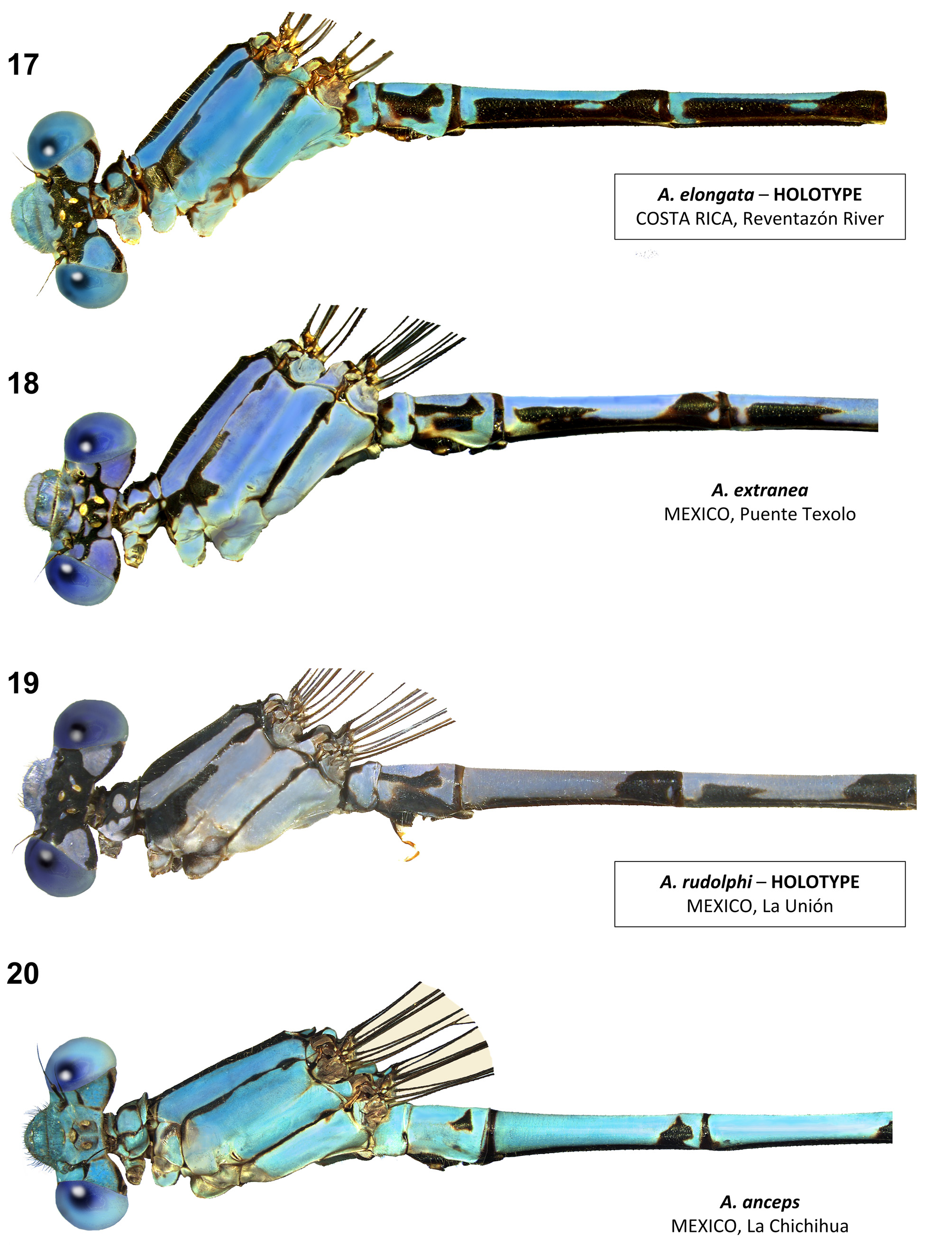

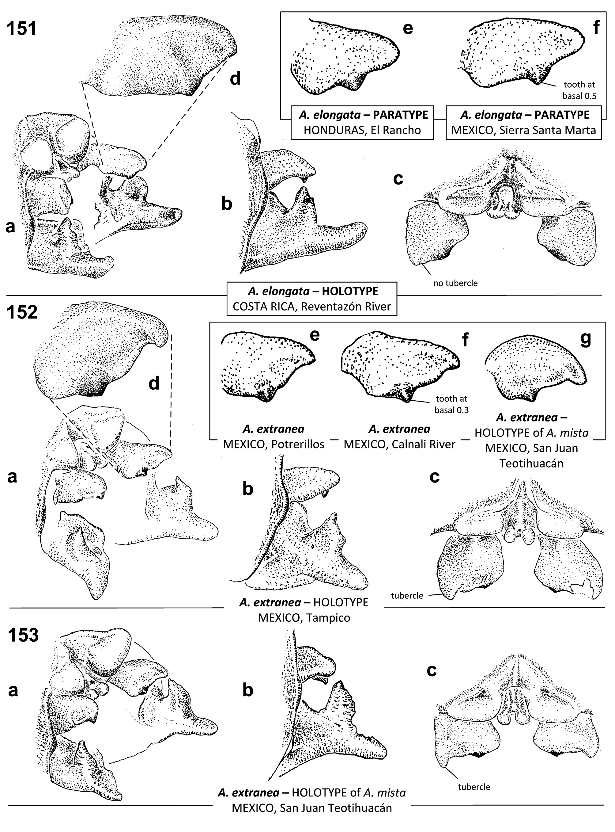
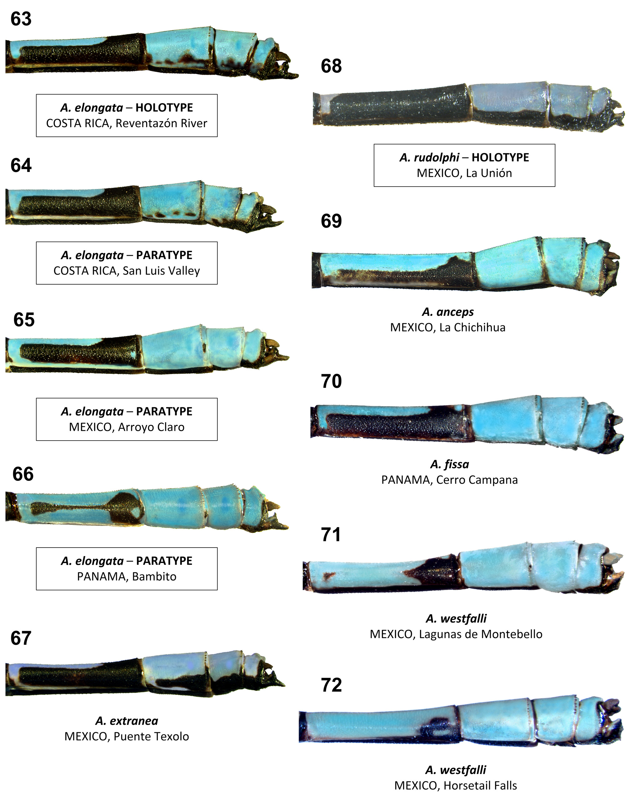
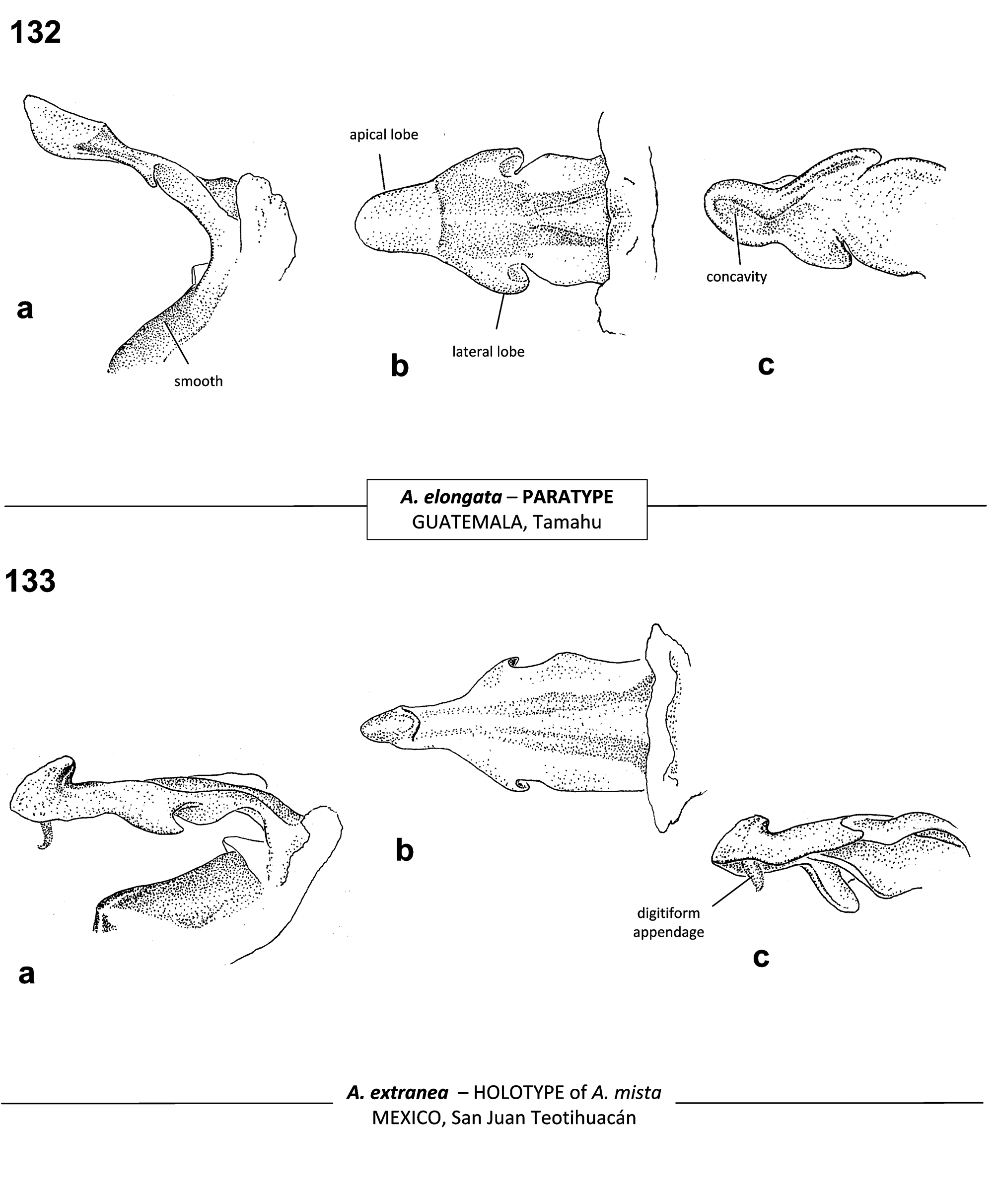

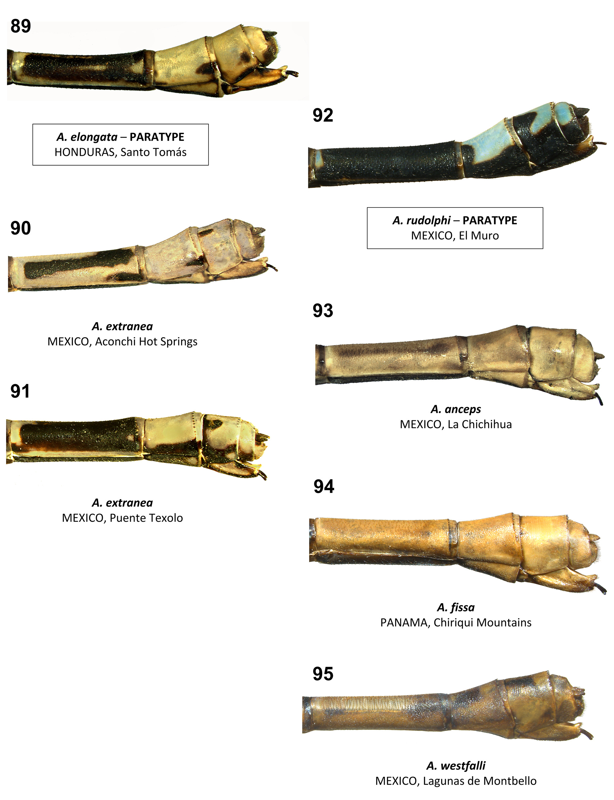
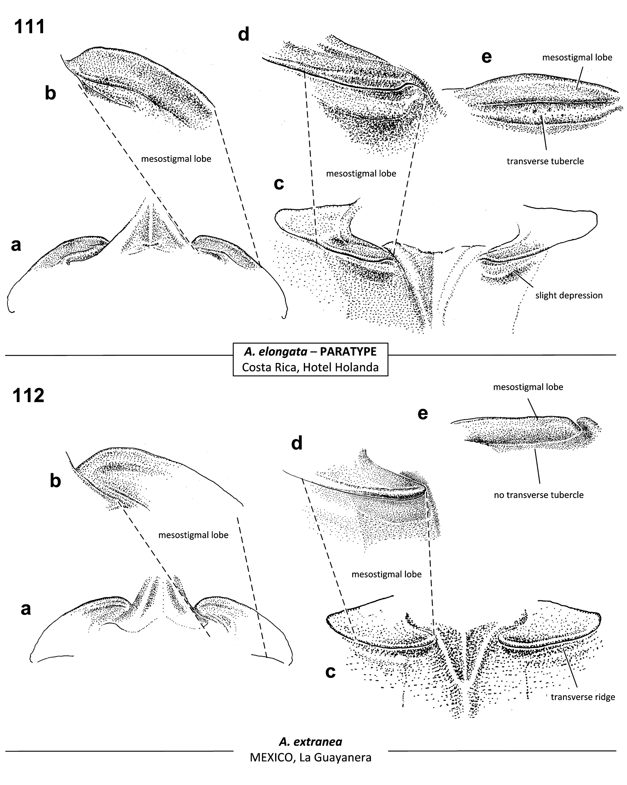
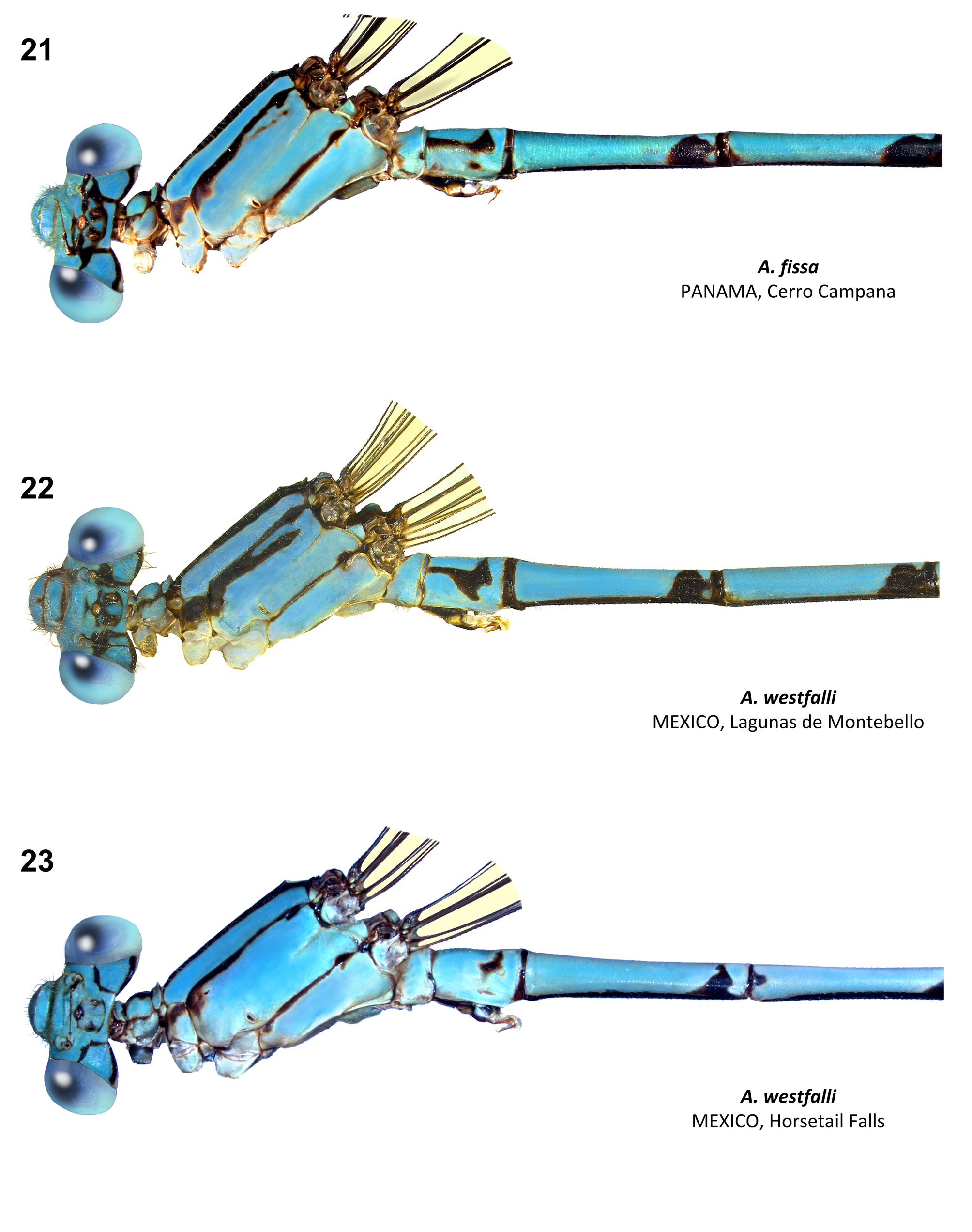
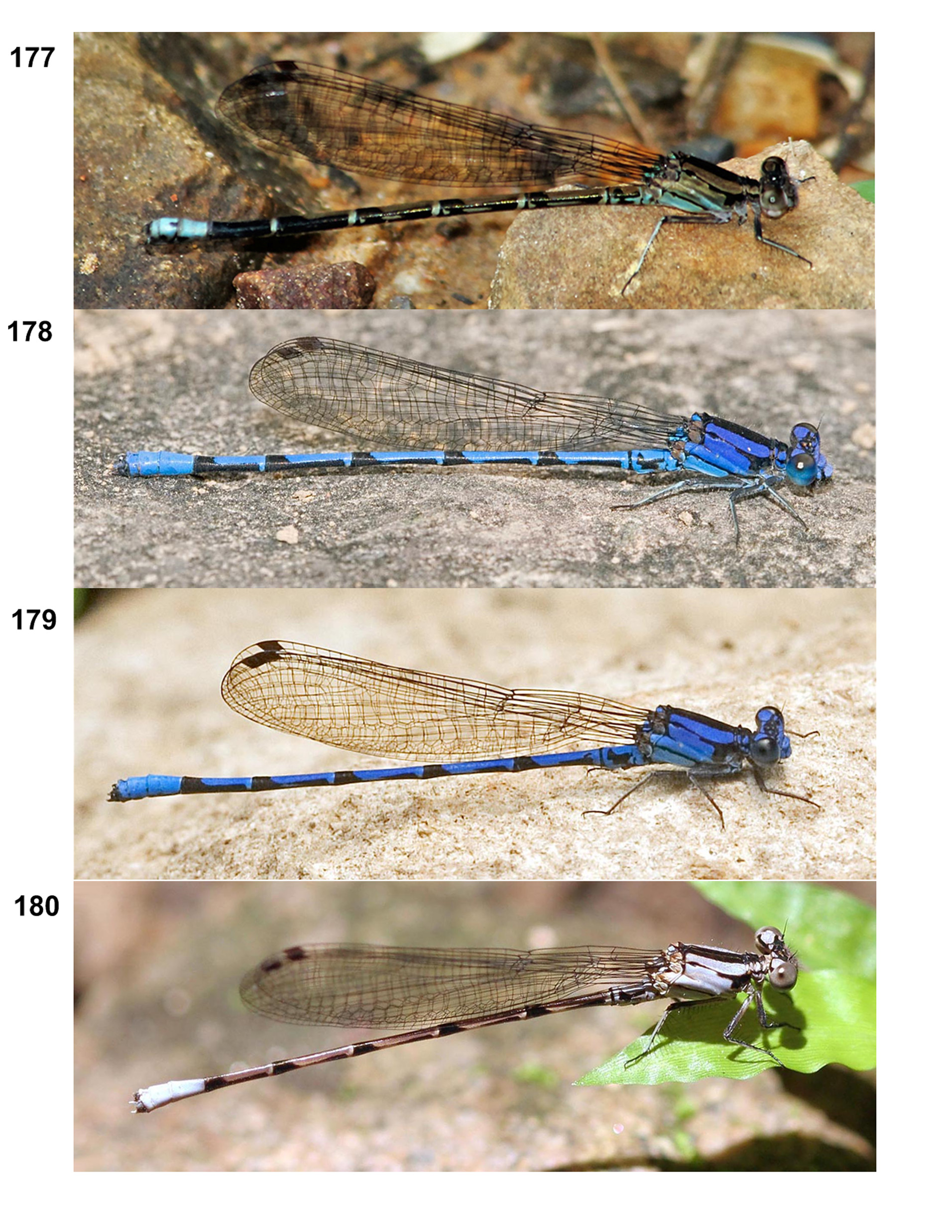

TABLE 4. Wing counts and measurements (average and standard deviation followed by range in square brackets) for various Argia species treated in this study.
| carolus ³ | 10 | 1–2 | 4 | 3–4 | 14–17 | 13–15 | 7–8 | 6–7 | 22.2 ± 1.1 [20.8–23.9] | 29.8 ± 1.4 [27.6–32.1] | 38.5 ± 1.8 [35.8–41.5] |
|---|---|---|---|---|---|---|---|---|---|---|---|
| Carolus ♀ | 7 | 1–2 | 4 | 3–4 | 14–16 | 12–14 | 7–8 | 6–7 | 21.8 ± 2.3 [18.5–24.7] | 26.5 ± 2.3 [23.3–29.3] | 34.9 ± 3.3 [30.5–38.5] |
| schneideri ³ | 10 | 1–2 | 3–5 | 3–4 | 16–18 | 14–16 | 7–9 | 6–7 | 20.9 ± 1.1 [19–22.3] | 27.3 ± 1.2 [25.7–29.3] | 35.2 ± 1.5 [33.3–37.8] |
| schneideri ♀ | 5 | 1.5–2 | 4–5 | 3–4 | 16–17 | 14–15 | 7–8 | 6–7 | 22.1 ± 1.4 [20.2–23.7] | 27.2 ± 1.8 [25.3–29.4] | 35.2 ± 2.1 [33.1–37.7] |
| haberi ³ | 3 | 1–2 | 4 | 3–4 | 15–16 | 13–14 | 7–8 | 6–7 | 22.9 ± 0.4 [22.5–23.3] | 29.4 ± 1.0 [28.3–30.2] | 37.6 ± 1.1 [36.8–38.4] |
| rhoadsi ³ | 10 | 1 | 3–4 | 3–4 | 12–16 | 11–13 | 6–8 | 5–6 | 20.9 ± 1.1 [18.6–22] | 28 ± 1.2 [26.1–29.6] | 35.4 ± 1.4 [33.3–37.5] |
| rhoadsi ♀ | 10 | 1 | 3–4 | 3 | 13–16 | 12–14 | 6–8 | 5–6 | 21.4 ± 0.8 [20.2–22.5] | 27.5 ± 1 [26.2–29.5] | 35.1 ± 1.2 [33.7–37.6] |
| popoluca ³ | 10 | 1–1.5 | 3–4 | 3 | 13–16 | 12–14 | 6–8 | 5–7 | 19.1 ± 1.3 [17.1–20.8] | 26.3 ± 2.1 [24–29.5] | 33.5 ± 2.5 [29.6–37.5] |
| popoluca ♀ | 9 | 1–1.5 | 3–4 | 3 | 13–15 | 11–13 | 7–8 | 5–6 | 19.7 ± 2.1 [17.2–22.1] | 25.3 ± 2.3 [21.6–28.1] | 32.4 ± 2.9 [28–35.8] |
| schorri ³ | 7 | 1 | 3–4 | 3 | 12–14 | 10–11 | 6–8 | 5 | 18.9 ± 0.9 [17.6–20.3] | 25.7 ± 1.2 [24–27] | 33 ± 1.3 [31.1–34.4] |
| schorri ♀ | 1 | 1 | 3 | 3 | 13 | 10 | 6–7 | 4 | 20.1 | 25.3 | 32.8 |
No known copyright restrictions apply. See Agosti, D., Egloff, W., 2009. Taxonomic information exchange and copyright: the Plazi approach. BMC Research Notes 2009, 2:53 for further explanation.
|
Kingdom |
|
|
Phylum |
|
|
Class |
|
|
Order |
|
|
Family |
|
|
Genus |
Argia elongata Garrison & von Ellenrieder
| Garrison, Rosser W. & Ellenrieder, Natalia Von 2017 |
Argia
| Ellenrieder 2013: 16 |
Argia
| Bailowitz 2012: 9 |
Argia
| Esquivel 2005: 152 |
Argia extranea:
| Heckman 2008: 347 |
| Westfall 2006: 189 |
| Forster 2001: 11 |
| Ramirez 2000: 249 |
| Boomsma 1996: 25 |
| Novelo-Gutierrez 1996: 163 |
| Garrison 1994: 309 |
| Donnelly 1992: 83 |
| Dunkle 1991: 132 |
| Maes 1989: 5 |
| Dunkle 1988: 45 |
| Maes 1988: 32 |
| Paulson 1984: 51 |
| Paulson 1982: 252 |
| Calvert 1919: 164 |
| Ris 1918: 116 |
| Calvert 1902: 93 |
Argia
| extranea Abbott et al. (2002) : 127 |