
Tritoxa decipiens, Sinclair & Macleod & Wheeler, 2021
|
publication ID |
https://doi.org/ 10.11646/zootaxa.4920.3.3 |
|
publication LSID |
lsid:zoobank.org:pub:20794FBC-E83E-419F-945D-4F94C6F9A47C |
|
DOI |
https://doi.org/10.5281/zenodo.4530731 |
|
persistent identifier |
https://treatment.plazi.org/id/04FAB0F1-E45D-4D0E-AB68-FCFFC7237E00 |
|
taxon LSID |
lsid:zoobank.org:act:04FAB0F1-E45D-4D0E-AB68-FCFFC7237E00 |
|
treatment provided by |
Plazi |
|
scientific name |
Tritoxa decipiens |
| status |
sp. nov. |
Tritoxa decipiens View in CoL sp. nov.
( Figs 8 View FIGURES 6–13 , 17 View FIGURES 14–17 , 25 View FIGURES 24–26 )
urn:lsid:zoobank.org:act:04FAB0F1-E45D-4D0E-AB68-FCFFC7237E00
Type material. HOLOTYPE ♂, labelled: “BC 30 km E/ Smithers [54°46′N 127°10′W]/ 15.VI.1989 / M.Pollak ”; “ HOLOTYPE / Tritoxa / decipiens Sinclair ,/ MacLeod & Wheeler” ( CNC) GoogleMaps . PARATYPES: CANADA. Alberta: Banff [51°10′N 115°34′W], 30.vii.1924, E. Hearle (1♂, 3♀, CNC) GoogleMaps , same data except, no date, N.B. Sanson (1♂, CNC) GoogleMaps ; same data except, Buffalo Pk , 4500 ft, 2,17.vii., 5.viii.1925, O. Bryant (1♂, 1♀, USNM) GoogleMaps ; Elkwater Park [49°39′39″N 110°16′54″W], 26.vii.1952, L.A. Konotopetz (1♂, CNC) GoogleMaps ; Dunvegan, N shore Peace River , south facing grassy slopes, 12–14.vii.1997, T.A. Wheeler, S. Boucher (9♂, 5♀, LEM) ; same data except, 55°55.59′N 118°35.74′W, 19.vii.2003, S. Boucher (1♂, LEM) GoogleMaps ; same data except, 55°55′25″N 118°35′40″, 21.vii.2003, V. Dion (1♀, LEM) GoogleMaps ; Lethbridge [49°41′39″N 112°49′58″W], 15.vi.1925, H.L. Seamans (1♂, CNC) GoogleMaps ; Peace River [56°14′02″N 117°17′23″W], 10.vii.1961,A. R. Brooks (1♂, CNC) GoogleMaps ; Waterton Lakes [49°02′N 113°54′W], 19.vi.1923, J. McDunnough (3♂, CNC) GoogleMaps ; same data except, 2.vii.1923 (1♀, DEBU) GoogleMaps ; Waterton , 11.vi.1962, K.C. Herrmann (2♂, 1♀, CNC) ; same data except, 13.viii.1922, H.E. Gray (1♂, CNC) . British Colombia: Adams Lake [51°15′N 119°30′W], 16.vi.1923, W.B. Anderson (1♂, 2♀, CNC) GoogleMaps ; Elko [49°18′N 115°06′W], GoogleMaps Chilcotin [51°52′N 123°15′W], 30.vi.1920, E. R. Buckell (1♂, CNC) GoogleMaps ; Elko [49°18′00″N 115°06′42″W], E. Kootenay, 9.vii.1949, H.B. Leech (1♀, CAS) GoogleMaps ; Lac la Hache [51°48′N 121°28′W], 12.vii.1964, L.H. McMullen (1♀, CNC) GoogleMaps ; Pouce Coupe [55°42′N 120°08′W], 1.vii.1927, P.N. Vroom (1♀, CNC) GoogleMaps ; Pavilion Lake [50.86677°N 121.74191°W], 5.vi.1938, G.S. Walley (1♂, 1♀, CNC) GoogleMaps ; Robson [49°20′08″N 117°41′19″W], 30.v.1948, 7.vii.1950, H. R. Foxlee (2♂, 2♀, CNC) GoogleMaps ; Rolla [55°54′N 120°08′W], 21.vii.1927, P.N. Vroom (1♂, CNC) GoogleMaps ; 30 km E Smithers [54°46′N 127°10′W], 15.vi.1989, M. Pollak (11♂, 7♀, CNC) GoogleMaps ; Williams Lake [52°07′N 122°08′W], 11.vii.1938, J.K. Jacob (1♀, CNC) GoogleMaps . USA. Arizona: Greer [34°00′N 109°27′W], 3.vii.1953, A.&H. Dietrich (1♂, USNM) GoogleMaps ; White River [34°00′N 109°27′W], 21.vi.1957, G. Butler & F. Werner (2♂, USNM) GoogleMaps ; White Mtns [33°54′N 109°33′W], 8.vii.1933, Parker (1♂, 1♀, USNM) GoogleMaps . Colorado: Boulder [40°00′N 105°16′W], 5500 ft, 16.vi.1961, B.H. Poole (2♂, CNC) GoogleMaps ; same data except, 19.vi.1961, W. R.M. Mason (1♂, CNC) GoogleMaps ; 5 mi S Boulder , 21–17.vi.1961, W. R.M. Mason (1♂, 2♀, CNC) ; same data except, 4 mi N, 20.vi.1961, C.H. Mann (1♂, CNC) ; Buckhorn Ck [40.4208169° -105.1752614°], 11.vii.1937, C.L. Johnston (1♂, USNM) ; 5 mi. W Denver , 17.vi.1965, J. R. Bider (1♂, LEM) ; Estes Park [40°22′N 105°31′W], 7500 ft, 2–16.viii.1961, B.H. Poole (5♂, 8♀, CNC) GoogleMaps ; same data except, 20.vii.1961, C.H. Mann (1♂, CNC) GoogleMaps ; same data except, J. R. Stainer (1♀, CNC) GoogleMaps ; Florissant [38°56′N 105°17′W], 8200 ft, vi.24.14, Champlain (1♂, USNM) GoogleMaps ; Gilpin Co., Kelly-Dahl [39°55′57″N 105°29′52″W], south of Nederland , 2615 m, 4.viii.1973, P.H. Arnaud (1♂, CAS) GoogleMaps ; Larimer Co., 15 mi. W Livermore [40°47′N 105°13′W], 1500 ft, 3.vii.1982, W.J. Pulawski (1♂, CAS) GoogleMaps ; Manitou [38°51′N 104°54′W], 25.vii.1903, Van Duzee (1♂, CAS) GoogleMaps ; near Meeker [40°2′N 107°54′W], 11.vi.1984, Ponderosa pine/prairie, H. Goulet (18♂, 24♀, CNC) GoogleMaps ; Nederland [39°57′N 105°30′W], Science Lodge, 9000 ft, 29.vii.1961, J. R. Stainer (1♂, 1♀, CNC) GoogleMaps ; same data except, 9500 ft, 29.vi.1961, B.H. Poole (1♀, CNC) GoogleMaps ; same data except, 8200 ft, W. R. M. Mason (1♀, CNC) GoogleMaps ; South Park, nr Jefferson [39°22′N 105°48′W], 21.vi.1961, C.H. Mann (2♂, 2♀, CNC) GoogleMaps ; Westlake [40.788701° -105.568232°], 7.vii.1900, no collector (1♂, USNM) . Idaho: Lehmi Co., Lehmi Pass [44°58′27″N 113°26′42″W], 7340–7500 ft, 16.vii.1978, J.F. G. & T. M. Clarke (1♂, USNM) GoogleMaps . Montana: Lolo [46°45′N 114°5′W], 1.vii.1904, no collector (1♀, USNM) GoogleMaps ; Silver Box Co., 14 mi. S Butte [45°59′N 112°31′W], 23.viii.1973, A.J. & M.E. Gilbert (1♂, CSCA) GoogleMaps . New Mexico: Cloudcroft [32°57′N 105°44′W], 8.vi.1968, R. Eads (2♂, 1♀, USNM) GoogleMaps ; Lincoln Co., Lincoln NF, 33°23′32.5″N 105°44′01.1″W, 2374 m, 7.vi.2010, T. N. & S.D. Gaimari (3♂, 1♀, CSCA) GoogleMaps ; same data except, White Mtns, Mills Cyn , 33°27′08.2″N 105°44′46.6″W, 1837 m, 14.vi.2007, S.D. Gaimari (1♂, 2♀, CSCA) GoogleMaps ; Raton [36°53′N 104°26′W], 19.vi.1937, E.D. Ball (1♂, 1♀, USNM) GoogleMaps . Utah: Henry Mtns, Bull Creek Pass [38°05′N 110°48′W], 10200 ft, 18.vii.1968, H.F. Howden (1♂, CNC) GoogleMaps ; Snowville [41°58′N 112°42′W], 2.vii.1950, F.C. Harmston (1♂, USNM) GoogleMaps . Wyoming: Red Gulch Rd. off Hwy. 14 nr. Shell [44°32′N 107°46′W], pans in barren area nr. cottonwoods, cow dung, 5–19.viii.1990, J.E. Swann (2♂, DEBU) GoogleMaps .
Diagnosis. This species can be recognized by the discal hyaline crossband ending in or very near the posterior corner of cell dm and inner surstylus with 5–8 thick prensisetae.
Description. Entirely reddish brown, abdomen darker. Head: ocellar triangle shiny black; frons reddish-brown to brown; silvery parafrontal microtrichose stripe very narrow, continuous with very narrow microtrichose parafacial; gena dark brown below narrowest part of lower eye margin; postocular microtrichia wider than parafrontal microtrichia in lateral view, extending from oral margin to middle of eye; face yellowish-brown to brown; supracervical setulae usually yellow. Antenna with postpedicel greyish brown, yellowish brown on ventral and basal surfaces. Proboscis with palpus concolourous with face. Thorax: reddish-brown to brown; scutum mostly thinly pruinescent with pair of whitish pruinescent vittae; lateral margin of scutum and postpronotal lobe broadly shiny; scutellum concolourous with scutum; mediotergite without distinct stripe; pleura shiny, posterior portion of anepisternum and katepisternum lightly clothed in whitish microtrichia when viewed obliquely; whitish microtrichia above fore coxa; 1 anepisternal seta. Wing ( Fig. 8 View FIGURES 6–13 ) rounded apically, brown, with some faded regions; costal cell without narrow hyaline band at humeral break, with hyaline band at apical fourth in line with discal hyaline crossband; hyaline area from apical region of Sc to R 1; oblique subbasal hyaline crossband reaching near mid-length of cell dm; discal hyaline crossband oblique, long, extending to or very close to posterior distal corner of cell dm, not displaced at R 4+5; subapical hyaline crossband nearly straight to slightly arched, anterior end not extending proximal to crossvein r-m; crossvein dm-m straight; anal lobe more weakly developed; calypter usually with broad white margin. Abdomen: brown to black tergites and sternites; pleural membrane infuscate. Male terminalia ( Fig. 16 View FIGURES 14–17 ): inner surstylus with 5–8 thick prensisetae distributed along curved inner margin; outer surstylus slender, longer than inner surstylus, arched mesally with rounded apex; subepandrial sclerite with scattered dark setae. Cercus with long apicolateral setae; apical margin pointed. Phallus long, with some 5 loops.
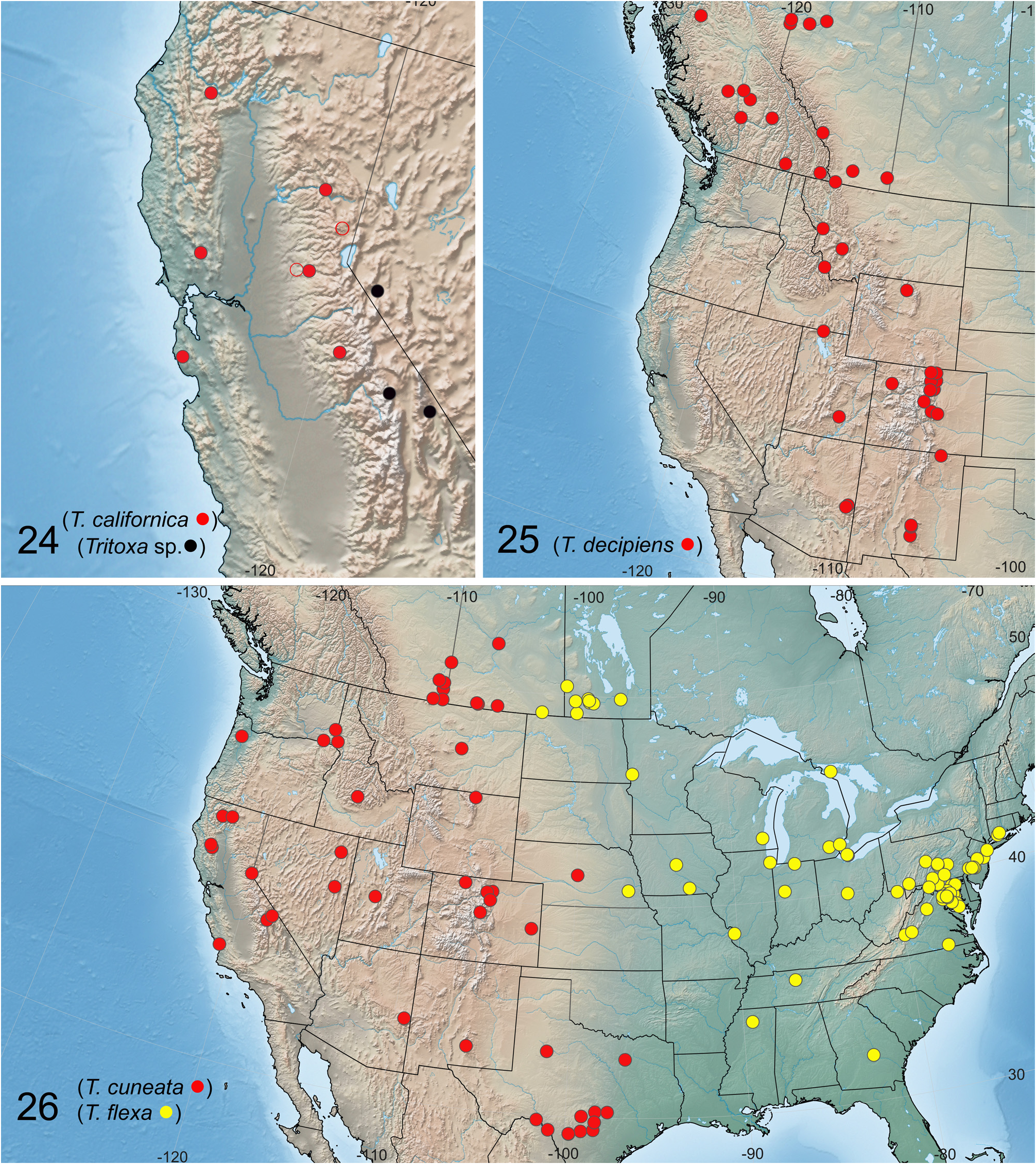
Distribution. Tritoxa decipiens is widespread along the Rocky Mountains and neighbouring ranges and areas from British Columbia and Alberta to New Mexico ( Fig. 25 View FIGURES 24–26 ).
Etymology. The species name is from the Latin decipiens (deceive), referring to the species’ similar appearance to T. cuneata .
Remarks. Steyskal had recognized and labelled several unpublished subspecies of T. cuneata from the USNM collection, including some identified here as T. decipiens sp. nov. These species appeared to be based on wing pattern differences, which are not supported on the basis of male terminalia.
See the Remarks section under T. cuneata for further comments.


| CNC |
Canadian National Collection of Insects, Arachnids, and Nematodes |
| USNM |
Smithsonian Institution, National Museum of Natural History |
| T |
Tavera, Department of Geology and Geophysics |
| V |
Royal British Columbia Museum - Herbarium |
| R |
Departamento de Geologia, Universidad de Chile |
| DEBU |
Ontario Insect Collection, University of Guelph |
| CAS |
California Academy of Sciences |
| CSCA |
California State Collection of Arthropods |
No known copyright restrictions apply. See Agosti, D., Egloff, W., 2009. Taxonomic information exchange and copyright: the Plazi approach. BMC Research Notes 2009, 2:53 for further explanation.