
Glossogobius giuris ( Hamilton, 1822 )
|
publication ID |
https://doi.org/ 10.11646/zootaxa.4974.1.3 |
|
publication LSID |
lsid:zoobank.org:pub:0FD68AAC-F4C5-4926-A7C7-EA475A2FACA2 |
|
DOI |
https://doi.org/10.5281/zenodo.4916960 |
|
persistent identifier |
https://treatment.plazi.org/id/3E753653-C23B-FFFB-24BF-FC5EFC94F9CA |
|
treatment provided by |
Plazi |
|
scientific name |
Glossogobius giuris ( Hamilton, 1822 ) |
| status |
|
Glossogobius giuris ( Hamilton, 1822) View in CoL
Figures 1 View FIGURE 1 , 2 View FIGURE 2 , 14–33 View FIGURE 14 View FIGURE 15 View FIGURE 16 View FIGURE 17 View FIGURE 18 View FIGURE 19 View FIGURE 20 View FIGURE 21 View FIGURE 22 View FIGURE 23 View FIGURE 24 View FIGURE 25 View FIGURE 26 View FIGURE 27 View FIGURE 28 View FIGURE 29 View FIGURE 30 View FIGURE 31 View FIGURE 32 View FIGURE 33 , Plates 1E–H View PLATE 1 , 3 View PLATE 3
Gobius giuris Hamilton, 1822: 50 View in CoL , pl. 33 (fig. 13), Ganges River, India.
Glossogobius giuris View in CoL .— Lake, 1978: 73, fig. (in part, Northern Territory and Western Australia; Allen, 1982: 66 (Kimberley and Pilbara regions, Western Australia); Allen, 1989: 205, pl. 43 (in part, photo from Maitland River and Western Australia and Northern Territory records; Merrick & Schmida, 1984: 311, fig. 258 (in part Western Australia and Northern Territory); Larson & Martin, 1990: 66, fig. 58 (Katherine River, Northern Territory); Allen et al., 2002: 268, (in part, photos and records from Western Australia); Hammer, 2018: 170 (Kimberley Region, Western Australia); Morgan, 2010: 363 (King Edward River and Carson River, Western Australia); Morgan et al., 2011: 18 View Cited Treatment (Kimberley Region, Western Australia); Pusey et al., 2017: 73 (in part).
Material Examined: Hammersley Range, Western Australia. Ashburton River System: AMNH 48556 View Materials , 2 View Materials (12–90), near Mindaroo homestead, ca 22°08’S, 115°05’E GoogleMaps ; AMS I.25505-002, 5(37–80), Highway crossing, 22°33’S, 115°30’E GoogleMaps ; WAM P.25908-002, 53(22–93), road crossing at Nanutarra Roadhouse , 22°33’S, 115°30’E GoogleMaps ; WAM P.28461-001, 1(65), Nanjigardy Pool , Turee Creek, Hammersley Range, 23°22’S, 117°49’E GoogleMaps ; WAM P.31387-006, 2(83–84), Glen Florrie Station , permanent pools, 23°04’S, 116°02’E GoogleMaps , WAM P.4707, 1(144), Junction of Duck and Serpentine Creek, 22°50’S 116°35’E GoogleMaps . Fortescue River System : NMV A.11328, 1(95), Whitenoon Gorge , 22°17’S, 118°19’E GoogleMaps ; WAM P.14620–14621, 2(53–126), Wittenoom area , 22°16’S, 118°25’E GoogleMaps ; WAM P.10051–10053, 3(79– 96), Langey Crossing , 17°44’S, 123°39’E GoogleMaps ; WAM P.15877, 1(193), Crossing pool, Millstream, 21°35’S, 117°04’E GoogleMaps ; WAM P.18118–18297, 177(20–107), Millstream Station , 21°35’S, 117°04’E GoogleMaps ; WAM P.18769–18809, 41(48–174), Wittenoom Gorge pool, 22°16’S, 118°25’E GoogleMaps ; WAM P.18821–18824, 4(120–141), Crystal Pool , Millstream Station, 21°34’S, 117°35’E GoogleMaps ; WAM P.18825–18829, 5(42–65), Deep Reach , Millstream, 21°34’S, 117°04’E GoogleMaps ; WAM P.5084, 1(105), Millstream , 21°35’S 117°04’E GoogleMaps . Maitland River System : AMNH 48520 View Materials , 5 View Materials (84–109), ca 20°51’S, 116°27’E GoogleMaps ; AMS I.18216-001, 17(36–185), near Dampier Archipelago , 20°51’S 116°39’E GoogleMaps ; AMS I.18217-001, 20(29–107), 20°51’S, 116°39’E GoogleMaps ; WAM P.25105-013, 22(31–152), near Dampier , 20°54’S, 116°40’E GoogleMaps ; WAM P.25867-003, 29(35–83), under highway bridge crossing, 20°50’S, 116°38’E GoogleMaps ; WAM P.9469, 1(80), 20°54 S, 116°41’E GoogleMaps . Kimberley Region Western Australia. Fitzroy River System : AMNH 48538 View Materials , 117 View Materials (22–130), NE Mt House homestead, Hann River , 16°57’S, 125°59’E GoogleMaps ; AMNH 48555 View Materials , 6 View Materials (25–67), Langley Crossing, ca 17°44’S, 123°39’E GoogleMaps ; AMS I.25528-004, 3(25–40), Adcock Gorge , 16°56’S, 125°49’E GoogleMaps ; AMS I.33468-009, 15(25–67), Mt. Pierre Gorge , 18°36’S, 126°04’E GoogleMaps ; NMV A.10919, 1(75), near Willaire Bridge , 17°25’S, 123°34’E GoogleMaps ; QM I.22411, 1(45), Palm Springs , Margaret River, 18°30’S, 126°26’E GoogleMaps ; QM I.22421, 29(47–66), Geikie Gorge , 18°04’S, 125°45’E GoogleMaps ; QM I.22428, 40(46–63), Waterhole , 200 m downstream from bridge from Derby, 17°45’S, 123°39’E GoogleMaps ; QM I.22473, 3(45–63), Adcock River , 17°13’S, 125°49’E GoogleMaps ; WAM P.25434-005, 1(73), Minnie River , 17°43’S, 123°38’E GoogleMaps ; WAM P.25435-005, 5(50–71), 17°43’S, 123°38’E GoogleMaps ; WAM P.25450-005, 8(32–68), Adcock River , 17°05’S, 125°33’E GoogleMaps ; WAM P.2618, 1(110), Noonkanbah , 18°31’S, 124°50’E GoogleMaps . May River System : QM I.22449, 70(17–52), on Meda Station , 17°23’S, 124°02’E GoogleMaps . Stewart River System : QM I.22435, 3(21–42), at Kimbolten Station , 16°44;S, 123°55’E . Meda River System : AMS I.20404-004, 3(60–109) and WAM P.25870-003, 7(54–120), Windjana Gorge , Lennard River, 17°25’S, 124°59’E GoogleMaps . Isdell River System : QM I.22468, 3(61–74), Saddler Spring , tributary of Grave Creek, 17°09’S, 125°28’E GoogleMaps ; QM I.22481, 5(59–135), Mount House Station , 17°00’S, 125°30’E GoogleMaps . Lawley River System : WAM P.25677-007, 4(62–81), 14°42 S, 125°57’E GoogleMaps . King Edward River System : AMS I.25533-005, 3(28–68), Highway crossing, 15°41’S, 126°23’E GoogleMaps ; AMS I.33462-003, 1(110) and AMS I.33462-006, 39(28–115), near Kalumburu Road turnoff, 18°36’S, 126°04’E GoogleMaps ; WAM P.25688-006, 2(48–80), 15°05’S, 126°11’E GoogleMaps . Carson River System : QM I.22540, 1(23), Monger Creek , 14°17’S, 126°33’E GoogleMaps ; WAM P.25412-003, 10(55–107), 14°49’S, 126°48’E GoogleMaps ; WAM P.25413-001, 11(51–69), 14°49’S, 126°48’E GoogleMaps ; WAM P.25414-005, 7(44–122), Orchid Creek , 14°50’S, 126°48’E GoogleMaps ; WAM P.25416-003, 3(65–92) and WAM P.25419-003, 4(52–972), Orchid Creek , 14°49’S, 126°49’E GoogleMaps ; WAM P.25420-007, 9(39–128), Worriga Gorge , 15°02’S, 126°40’E GoogleMaps . Drysdale River System : AMS I.20403-006, 15(33–106), N of Drysdale Station , 15°39’S 126°21’E GoogleMaps ; AMS I.25530-001, 7(52–75), Highway crossing, 15°41’S, 126°23’E GoogleMaps ; AMS I.25532-002, 67(15–102), Highway crossing, 15°41’S, 126°23’E GoogleMaps ; NMV A.31724-002, 1(77), upper section at Miners Pool , 15°40’49”S, 126°24’24”E GoogleMaps ; NTM S.13033-003, 1(36), Middle section, 14°26’S 126°51’E GoogleMaps ; QM I.22523, 2(63–86), Doongan Station , 15°28’S, 126°39’E GoogleMaps ; QM I.22404, 2(64–67), sandy crossing, 14°26’S, 126°52’E GoogleMaps ; WAM P.25404-009, 6(45–85), 15°03’S, 126°55’E GoogleMaps ; WAM P.25405-008, 7(60–113), Mogurnda Creek , 15°02’S, 126°55’E GoogleMaps ; WAM P.25407-006, 7(37–118), 15°02’S, 126°55’E GoogleMaps ; WAM P.25410-009, 5(50–133), 15°01’S, 126°54’E GoogleMaps ; WAM P.25424-010, 5(35–112), 14°39’S 126°57’E GoogleMaps ; WAM P.25427-009, 10(37–126), 14°38’S, 126°58’E GoogleMaps ; WAM P.25873-008, 10(36–98), at Drysdale station , 15°39’S, 126°21’E GoogleMaps . Durack River System : AMS I.25536-003, 1(78), Parry Creek , 16°16’S, 127°11’E GoogleMaps ; WAM P.25876-003, 2(76–78), crossing on Wyndam Road , 15°57’S, 127°14’E GoogleMaps . Pentecost River System : AMS I.25537-002, 1(91), Highway crossing, 15°48’S, 127°53’E GoogleMaps ; AMS I.33454-012, 14(19–48), Jackaroos Waterhole , El Questro Station, 16°01’S, 128°00’E GoogleMaps ; NTM S.17671-005, 5(47–97), Moonshine Gorge , 16°02.64’S, 128°01’E GoogleMaps . Forrest River System : QM I.22625, 1(79), Warringali Creek , 15°10’S, 127°41’E GoogleMaps . Ord River System : AMNH 48585 View Materials , 6 View Materials (51–110), Muggs Lagoon in Parry Creek , 15°40’S, 128°17’E GoogleMaps ; AMNH 48760 View Materials , 3 View Materials (20–108) and AMNH 48776 View Materials , 5 View Materials (51– 82), Bow River , Nicholson – Wyndam Highway, ca. 16°49’S, 128°37’E GoogleMaps ; AMS I.16835-002, 5(41–73), Behn River mouth, 16°13’S, 128°43’E GoogleMaps ; AMS I.16836-001, 3(52–54), Behn River , 16°19’S, 128°49’E GoogleMaps ; NMV A.3535, 5(42–80), Behn River , 16°23’S, 128°51’E GoogleMaps ; NMV A.3543, 3(55–60), Behn Pool , 16°28S, 128°55’E GoogleMaps ; NTM S.16399-006, 1(91), Lake Argyle , Limestone Creek, 16°40’S, 128°32’E GoogleMaps ; NTM S.16400-003, 2(84–130), Lake Argyle , Limestone Creek, 16°39’S, 128°34’E GoogleMaps ; NTM S.16410-004, 2(80–118), Lake Argyle , Limestone Creek, 16°42’S, 128°27’E GoogleMaps ; NTM S.17605-001, 5(55–112), Smoke Creek , 16°33.0’S, 128°30.2’E GoogleMaps ; NTM S.17609-002, 5(43–115), Matilda Creek , 16°08.23’S, 129°04.5’E GoogleMaps ; NTM S.17612-004, 1(100), Limestone Creek , 16°40.56’S, 128°29.31’E GoogleMaps ; NTM S.17613- 002, 2(41–79), Galloping Creek , 16°35.21’S, 128°25.36’E GoogleMaps ; NTM S.17618-001, 4(55–93), Limestone Creek , 16°43.01’S, 128°26.85’E GoogleMaps ; NTM S.17620-005, 3(75–86), Forest Creek , 17°24.03’S, 128°52.06’E GoogleMaps ; NTM S.17624- 003, 7(82–107), Limestone Creek , 16°39.67’S, 128°31.39’E GoogleMaps ; NTM S.17630-001, 3(84–95), Smoke Creek , 16°31.61’S, 128°32.17’E GoogleMaps ; NTM S.17632-004, 2(60–60), Limestone Creek , 16°41.49’S, 128°28.46’E GoogleMaps ; NTM S.17639-001, 1(125), Flying Fox Creek Gorge, 16°34.34’S, 128°20.44’E GoogleMaps ; NTM S.17640-001, 1(112), Linnekar Creek , 17°32.76’S, 128°42.7’E GoogleMaps ; QM I.22617, 2(29–108), Lake Kununurra , 15°48’S 128°41’E GoogleMaps ; SAM F.6586, 5(45– 50), near Lake Argyle , 16°02’S, 128°47’E GoogleMaps ; WAM P.13844, 1(123), Parry Creek , 15°25’S, 128°10’E GoogleMaps ; WAM P.13907, 1(93), Parry Creek , 15°25’S, 128°10’E GoogleMaps ; WAM P.13924–13925, 2(102–122), Halls Creek , Black Elvire River, 18°30’S, 127°45’E GoogleMaps ; WAM P.21184–21185, 2(31–46), Stockyard Pool , 16°20’S, 128°50’E GoogleMaps ; WAM P.21188–21190, 3(51–56), lower part of river, 15°30’S, 128°21’E GoogleMaps ; WAM P.21191–21195, 13(31–68), Argyle Downs , Behn River, 16°19’S, 128°49’E GoogleMaps ; WAM P.21196, 1(80), Lake Argyle , 16°20’S, 128°50’E GoogleMaps ; WAM P.21197–21201, 22, mouth of River , Behn River, 16°13’S, 128°43’E GoogleMaps ; WAM P.21202–21203, 2(64–107), pool at old Lissadell , 16°40’S, 128°33’E GoogleMaps ; WAM P.30039-008, 1(81), Bungle Bungles , 17°16’S, 128°31’E GoogleMaps . Northern Territory. Keep River System : NTM S.11405-006, 27(39–110), Policenman’s Waterhole , ca 15°51’S, 129°07’E GoogleMaps ; NTM S.14778-005, 14(14–76), Sandy Creek Billabong, 15°23.63’S, 129°11.17’E GoogleMaps ; NTM S.16103-003, 1(141), Policeman’s Waterhole , 16°16’S, 129°04’E GoogleMaps . Victoria River System : AMS I.20848, 10(26–60), cleared and stained, AMS I.20848-006, 151(13–105) and AMS I.20848-017, 1(57), Jasper Gorge , 16°02’S, 130°42’E GoogleMaps ; AMS I.20850-005, 3(29–64), Big Horse Creek , 15°38’S, 130°23’E GoogleMaps ; AMS I.20852-006, 12(28–91), S of Wickham Gorge , 16°48’S 130°39’E GoogleMaps ; AMS I.20861-002, 60(9–77), Wickham Gorge , 16°40’S, 130°40’E GoogleMaps ; AMS I.20863-006, 2(42–52), S of Wickham Gorge , 16°44’S, 130°40’E GoogleMaps ; AMS I.20866-001, 6(12–80), Water Bag Creek , 16°22’S, 131°25’E GoogleMaps ; AMS I.20889-007, 9(15–61), Wickham Gorge , 16°40’S, 130°40’E GoogleMaps ; AMS I.20896-004, 5(23–66), East Baines River , 15°46’S, 130°02’E GoogleMaps ; AMS I.20997-004, 5(38– 76), Bullo River , 15°42’S, 129°38’E GoogleMaps ; NTM S.11543-003, 4(37–51), Wattie Creek , 15°20’S, 131°20’E GoogleMaps ; NTM S.11600-003, 2(50–52), Wattie Creek , 15°20’S, 131°20’E GoogleMaps ; NTM S.11866-005, 2(45–45), East Baines River ; NTM S.11875-004, 43(12–85), NTM S.11876-005, 2(79–94), NTM S.11876-012, 2(59–63), NTM S.11877-001, 1(138) and NTM S.11879-002, 2(25–38), Roderick Creek , ca 15°39’S, 131°29’E GoogleMaps ; NTM S.11882-003, 6(19–69), Humbert River , 16°16’S, 130°50’E GoogleMaps ; NTM S.11885-002, 5(51–55), Wickham River , 16°28’S, 130°50’E GoogleMaps ; NTM S.12167-001, 6(34–55), East Baines River , ca 16°08’S, 130°26’S ; NTM S.14126-001, 5(36–59), Wickham River , 16°42’S, 130°39’E GoogleMaps ; NTM S.14127-003, 3(32-38), East Baines River , 16°03’S, 130°23’E GoogleMaps ; NTM S.14128-003, 9(30-53), south of road crossing, 16°03’S, 131°06’E GoogleMaps ; NTM S.14133-005, 5(31-35), East Baines River , 15°53’S, 130°04’E GoogleMaps ; NTM S.14134-003, 6(26-70), West Baines River , 5°57’S, 129°44’E GoogleMaps ; NTM S.17648-007, 4(42-56), old Victoria River crossing, 15°35’S, 131°06’E GoogleMaps ; NTM S.17917-006, 1(127), East Baines River , 16°02.76’S, 130°22.92’E GoogleMaps ; NTM S.18144-017, 6(43–108), tributary of Angalarri River . 14°59.2029, 130°57.4074’E ; WAM P.25882-002, 1(77), East Baines River , 15°45’S, 130° 02’ E GoogleMaps . Fitzmaurice River System : NTM S.1873-001, 1(55), Dee Creek , 14°41’S, 130°55’E GoogleMaps ; NTM S.18139-012, 14(36–110), tributary, Gorge Valley , 14°59’54”S, 130°27’26”E GoogleMaps . Daly River System : NTM S.14105-008, 18(27-86), Fish River , 14°14’S, 130°55’E GoogleMaps ; NTM S.14121-004, 2(34-42), Fergusson River , 13°59’S, 132°18’E GoogleMaps ; NTM S.17338-004, 7(50–70), Mut Pong Creek , 14°13’S, 131°01’E GoogleMaps ; NTM S.18181-001, 1(127), Aroona Creek , 15°23’36”S, 131°05’57”E GoogleMaps ; NTM S.18186-002, 1(104) and NTM S.18201-001, 2(77–84), lower Daly River , 13°52’S, 131°04’E GoogleMaps ; NTM S.18188-001, 2(29–99), Katherine River , 14°33’S, 132°08’E GoogleMaps ; NTM S.18192- 001, 1(122), Cullen River , 14°02’S, 131°57’E GoogleMaps ; NTM S.18193-001, 3(78–108), Katherine River , 14°33’S, 132°11’E GoogleMaps ; NTM S.18194-001, 3(89–141), Katherine River , 14°04’S, 132°08’E GoogleMaps . Madagascar. AMNH 96976 View Materials , 1 View Materials (42), Tamatave Province , mouth of Mangoro River by Salehy Village ; AMNH 96982 View Materials , 3 View Materials (131–150), River Mangoro , Tamatave Province, near Ifasina Village ; AMNH 231411 View Materials , 2 View Materials (143-152), Andempona River at Ampanam Savanna Village, 14°36’S, 50°10.13’E GoogleMaps ; AMNH 232455 View Materials , 1 View Materials (89), Anjambazamba River , 13°59.77’S, 49°58.86’E GoogleMaps . South Africa. AMS IA. 6926, Durban ; NTM S.16362-006, 2(16–78), Lagoon , Zinkwazi River ; NTM S.14697-001, 1(91), St. Lucia Estuary ; NTM S.15439-008, 1(41), Kosi Bay Lakes, Kwa-Zulu / Natal ; NTM S.16359-002, 4(27–46), Umhlatuzi River , Richards Bay ; NTM S.16361-002, 1(96), Amatikulu River ; NTM S.16369-003. 1(52), Zotsha River Estuary ; NTM S.16362-006, 2(16–28), Lagoon , Zinkwazi River. Sri Lanka . BMNH 1981.1.21:1053, 1(185) . USNM 268293 View Materials , 3 View Materials (40–65), tributary of Badula Oya 14.4 mi east of Madugoda on road to Bibile. Bangladesh . AMS uncatalogued 2(58–84) and NTM S,15943-001, 3(61–126), Matamohuri Basin , Banglao Bay. India . AMS B.8112, 1(245), Madras , India, Day specimen ; MCZ 52453, 6 View Materials (22–75), Katraj River ; MCZ 52454, 5 View Materials (35–109), Katraj River. Maylasia . AMS I.30463-021, 2(85–100). Singapore or Malaysia . NMW 30534, 1 View Materials (75) .
Diagnosis: Predorsal area scaled forward near to eyes, with distinct naked patch usually present, with scales usually not reaching post orbital pore. Operculum rarely naked, usually with a small patch of cycloid scales dorsally, rarely reaching posterior to middle of operculum, total scales usually 2–11, varying from 0–28, arranged in 1–3 vertical rows. Prepelvic area covered with cycloid scales in about 7–12 rows in Australian material, up to 16 in specimens from Bangladesh, ending usually behind posterior preopercular margin, with large naked area anteriorly, about one–third to one–half in Australian material, sides of isthmus often naked; pectoral fin base partly scaled, mainly with scales on central region of base in young, largely scaled in larger adults anteriorly, but not reaching to base of pectoral fin–rays in about 1–10 horizontal rows, often naked, or with few scales centrally, rarely reaching to bases of pectoral rays; prepelvic area about half scaled not reaching forward to below or just behind posterior preopercular margin. Pectoral rays 15–21, usually 17–20, varying between populations; predorsal scale count 15–21 in Australia, varying between populations, 15–24 from populations outside of Australia; transverse scale count (TRB) 8.5–10.5, usually 8.5–9.5. Gill rakers on outer face of first arch 1–2+1+6–9, usually 1–2+1+7–8; lower gill rakers on outer face of second arch 7–10; branched caudal rays 12–14. First dorsal spines often with black tips and black often on membranes between spines. Tip of urogenital papilla of female with a thin line of melanophores. Mental frenum uniformly pigmented, usually dark brown, rarely with pigment more intense at margin, central portion often covered with mucous and can appear darker at edges, lower surface of head usually with two large dark brown spots behind mental frenum, often with a thin line of brown pigment connecting two spots; body without thin dark brown stripes or with one to three very faint brown stripes, rarely with dark brown broken stripes ( Plate 1 View PLATE 1 ); brown spots on midside variable, horizontally elongate to round ( Figures 15–30 View FIGURE 15 View FIGURE 16 View FIGURE 17 View FIGURE 18 View FIGURE 19 View FIGURE 20 View FIGURE 21 View FIGURE 22 View FIGURE 23 View FIGURE 24 View FIGURE 25 View FIGURE 26 View FIGURE 27 View FIGURE 28 View FIGURE 29 View FIGURE 30 ).
Description: Based on over 400 specimens from Australian, 30–192 mm SL. Data from other localities listed separately. First dorsal spines 6(45); Maitland and Fortescue River Systems I,8(16), I,9(43); anal rays I,7(2); I,8(41), I,9(6); other localities: second dorsal rays I,8 (2), I,9(45), I,10(2); anal rays I,7 (1), I,8(47), I,8(1); longitudinal scale count (LSC) 29(14), 30(25), 31(16), 32(4); LSC South Africa 29(3), 30(4), LSC Bangladesh 30(1), 31(2), 32(1), LSC Madagascar 29(1), 30(3), 31(1); segmented caudal segmented caudal rays 9/8(43); branched caudal rays 12(13), 13(11), 14(34); vertebrae 11+16(4), 10+17(8).
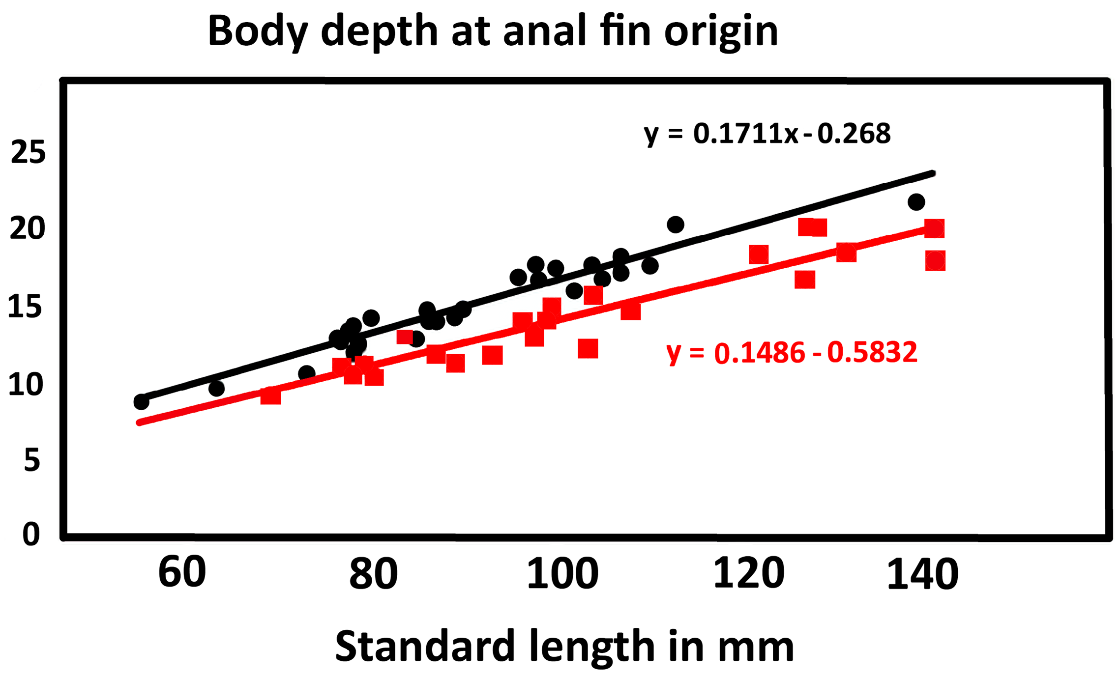
Mouth large; reaching to below a point approximately below anterior margin of eye in specimens up to 100 mm SL and to below middle of pupil in larger adults; jaws forming an angle of 28–32° with body axis; upper margin of upper jaw in line with middle to lower margin of eye. Cheeks narrow, tapering in dorsal view, rarely slightly bulbous. Interorbital narrow, less than eye diameter to about equal to eye diameter. Head moderate, proportion increasing with size, 28.8–30.9% SL in specimens from 50–70 mm SL, 30.0–32.9% SL in specimens 71–100 mm SL, 30.2–33.6% SL in specimens 101–140 mm SL, predicted mean varying from 30.6–32.3% SL over size range examined. Snout broadly rounded in dorsal view; with a notch in side view from upper extension of ascending process of premaxilla well in front of eye; 8.5–12% SL. Eye about 2–3 in snout, 6–7.8% SL in specimens below 70 mm SL, 4.6–6.8% SL in specimens above 70 mm SL, relative proportion decreasing with size. Upper jaw 10.4–12.7% SL in specimens below 70 mm SL, 11.4–14.6% SL in specimens above 70 mm SL. Small bump below nostrils absent or indistinct. Anterior nostril at end of short tube, 1–2 nostril diameters above upper lip. Posterior nostril well before eye, closer to upper lip than eye, and 1–3 nostril diameters from anterior nostril. Preoperculum moderate, distance from end of eye to upper posterior preopercular margin much less than snout length (about half to two thirds snout length); preoperculum with small blunt projection at angle. Postorbital moderate, subequal to from tip of snout to anterior margin to middle of eye. Gill opening broad, reaching to just anterior to posterior margin of preoperculum. Teeth in upper jaw: outer row of teeth conical fixed, slightly enlarged and wideset, 2–4 inner rows of smaller depressible, inwardly directed teeth, innermost row larger than middle row and largest anteriorly. Teeth in lower jaw: teeth in outer row conical, slightly enlarged and wideset anteriorly, 2–3 inner rows of smaller depressible teeth. Tongue tip bilobed. Gill rakers on outer face of first arch short and triangular, less than one-third filament length. Rakers on inner face of first arch and other arches short and denticulate. Cheek naked. Body covered mostly with large ctenoid scales, ctenii weakly developed or absent on scales at side of nape above operculum, cycloid on anteromedian predorsal region, pectoral base, prepelvic area and midline of belly; belly fully scaled. First dorsal fin low, with rounded to triangular margin, sometimes with second spine filamentous in males, second to sixth (usually second) spines extending beyond other spines when fin depressed; origin of fin well behind pelvic insertion. Second dorsal fin height subequal to first, posterior rays not prolonged in females, reaching about half way to caudal fin when adpressed, elongate in adult males reaching to near end of caudal peduncle. Anal fin slightly lower than second dorsal fin, posterior rays prolonged as in second dorsal fin in mature males, but not reaching caudal fin. Pectoral fin with rounded margin, reaching to well before anus, insertion before pelvic origin, length 19.9–25.0% SL over size range of 50–141 mm SL Pelvic disc without thickened rays, much longer than wide, length 19.1–22.1% SL over size range of 50– 41 mm SL; pelvic fin reaching to or almost to anus in specimen up to 100 mm SL, ending well before anus in larger adults. Caudal fin with rounded margin, 22.0–29.8% SL over size range of 50–141 mm SL. Body depth at pelvic origin 13.3–17.2% SL, not showing significant change with size over range of 69–132 mm SL. Body depth at anal origin 12.2–17.4% SL over size range of 69–141 mm SL. Caudal peduncle depth 8.5–10.7% SL, not showing significant change with size over range of 69–132 mm SL.
Head pores: Nasal pore immediately above posterior nostril; median anterior interorbital pore present above anterior quarter of eye; median posterior interorbital pore above posterior margin of eye; postorbital pore behind eye present in line with upper margin of pupil; infraorbital pore below postorbital present; lateral canal pore above posterior quarter of preoperculum; terminal lateral canal pore above and just behind posterior preopercular margin; short tube above posterior quarter of operculum, with pore at each end; 3 preopercular pores, upper in horizontal line with lower margin of eye; middle pore much closer to lower than to upper.
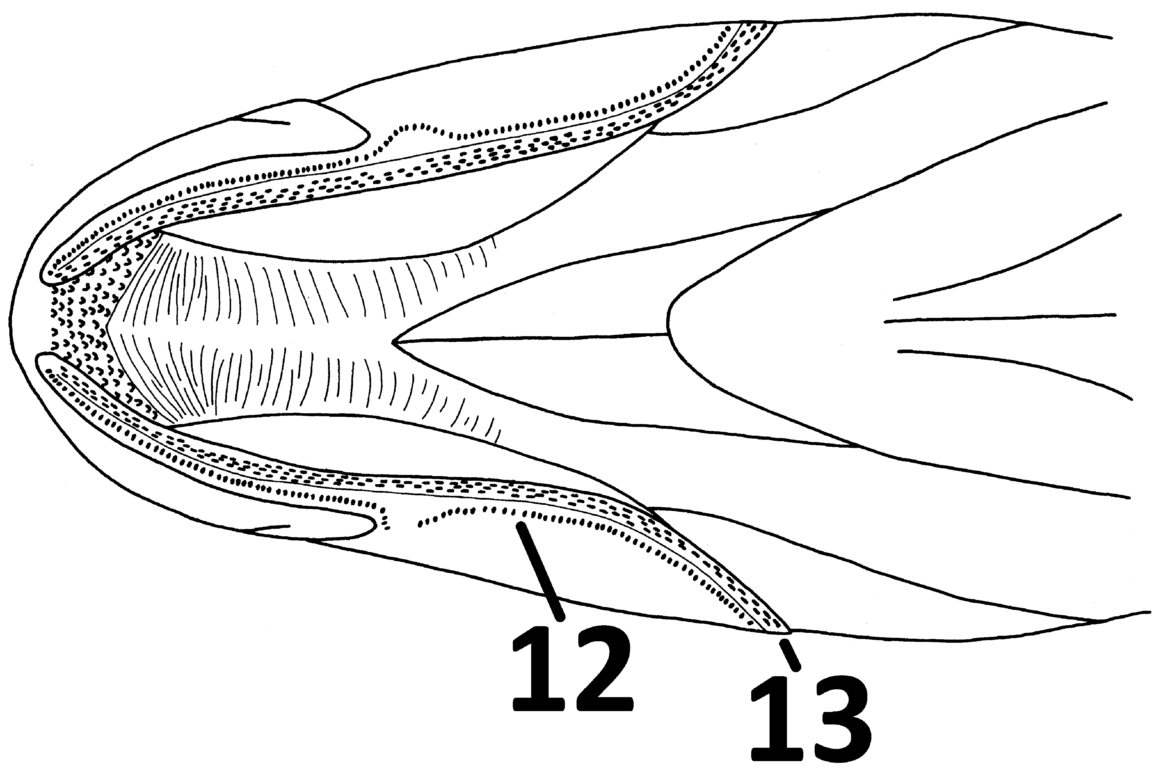
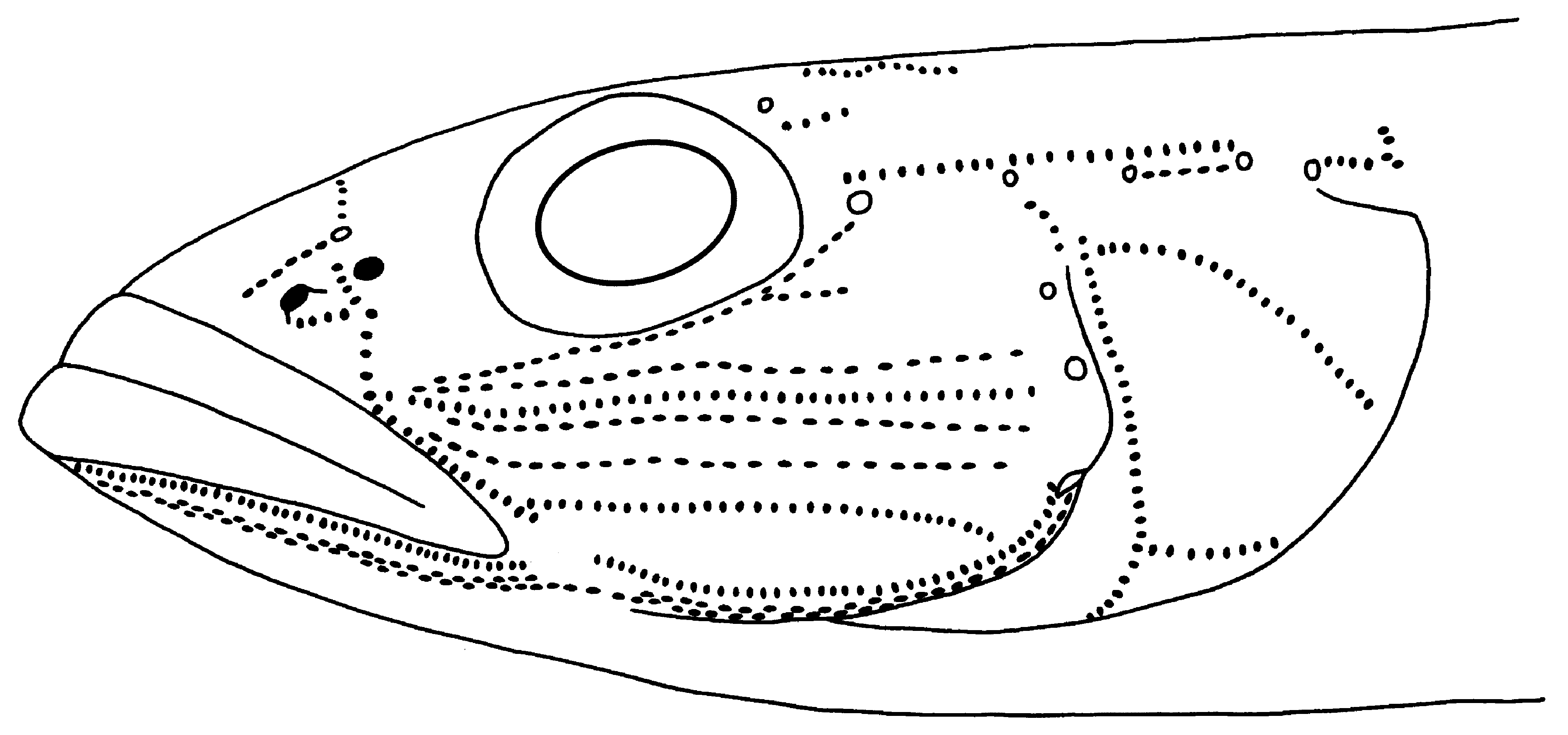
Sensory Papillae ( Figures 1 View FIGURE 1 , 2 View FIGURE 2 & 14 View FIGURE 14 ): Based on specimens 70–150 mm SL. Line 1 (before nasal pore) composed of 2 rows of papillae in adults. Line 2 (between nasal pores) curved, composed on single row of papillae, continuous across snout. Line 5 (suborbital) composed of one or two rows of papillae in in specimens between 50 and 110 mm SL. Line 6 (suborbital branch) short, composed of 1 row of papillae. Line 7 composed on single row of papillae posteriorly, 2-3 rows anteriorly. Line 9 composed of two rows of papillae; 7 usually with fewer rows than lines 9 and 10. Line 10 composed of 2–3 rows. Lines 8 and 11 composed of single row of papillae, straight, reaching to posterior preopercular margin. Line 12 (= Outer POP-mandibular line) composed of 2 rows around chin, single elsewhere, with no gap at end of jaws or with short gap. Line 13 (= Inner POP-mandibular line) composed of 2–3 rows of papillae, with no gap at end of jaws, but fewer rows and usually 2 rows along preoperculum. Line 20 composed of one row of papillae, curved backwards ventrally, breaking up into multiple rows anteriorly to form line 23, but only along lower margin of operculum. Line 21 a curved line, composed of single row, rarely with one or two parallel lines above. Line 22 short with vertical branches ventrally and posteriorly. Several vertical papillae rows on belly. A single curved line anteriorly on most body scales (often obscure dorsally and posteriorly). Extensive coverage of chin by papillae, almost reaching lips, but not covering dark mental frenum, usually in 2 patches on each side of chin, with jointed anteriorly, with separate wings posteriorly. Line 15, single row of papillae from end of eye to anterior part of lateral canal tube. Line 17 single row between terminal lateral canal pore and lateral canal tube. Line 19 single behind lateral canal pore behind eye to just behind or above upper preopercular pore ending close to and separate from line 20.
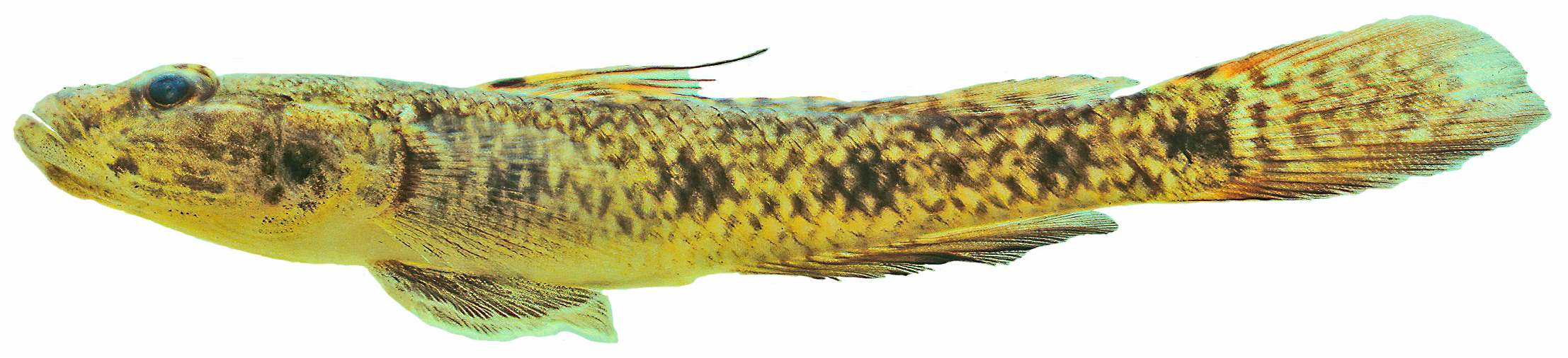
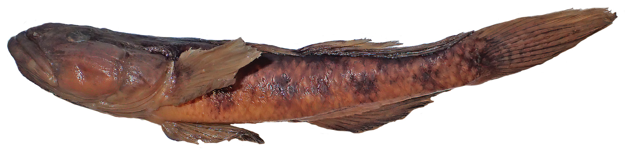
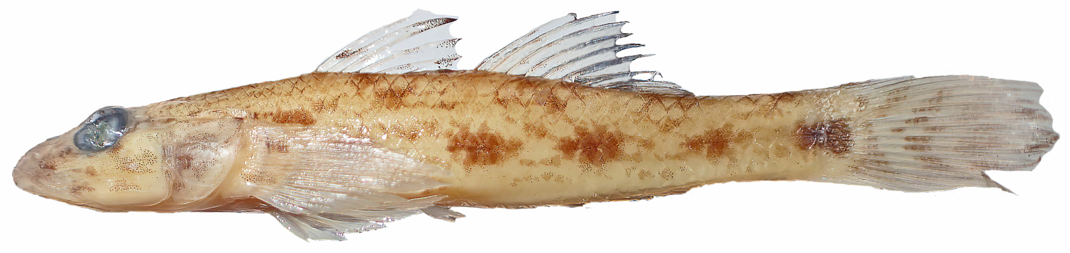
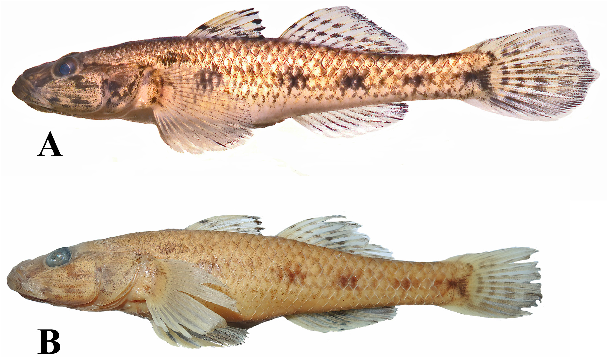
Coloration of freshly collected Australian specimens ( Figures 15 View FIGURE 15 , 30a View FIGURE 30 , Plate 3 View PLATE 3 ): Top of eye usually with a distinct transverse bar extending from interorbital to over iris, sometimes with blotches before and behind but usually only with bar. Head and body brown, pale below. Top of head from interorbital region to end of snout usually darker than rest of head; a dark brown bar from anteroventral margin of eye to middle of lips; an oblique, broad, brown bar from posteroventral margin of eye extending posteroventrally to horizontal bar, extending to posterior preopercular margin, rarely broken into series of 2–3 short bars; an horizontally elongate bar behind lips on lower part of preoperculum; operculum brown, with large dark brown or a series of smaller brown blotches anteriorly, with dark pigment of inner surface of operculum showing through and in some darker than spots on outer face of operculum; posterior end of lips usually without pigment, with a dark brown spot on cheek just above posterior end of jaws; pectoral base with long and thin horizontal brown stripe dorsally, extending onto base of pectoral ray; a fainter lower brown horizontal dark brown stripe or elongate spot just above ventral base of pectoral fin; mental frenum dark brown, pigment behind frenum variable as described in diagnosis ( Plate 1 View PLATE 1 ). Body with scattered brown mottling dorsally; a short, horizontally elongate, brown stripe or oblong spot above and just behind pectoral fin base. Midside with series of large brown spots, covering 2–4 scale rows horizontally and usually 2–3 rows vertically; midside spots usually horizontally elongate, rounded and large in some specimens; first spot below middle to anterior quarter of first dorsal fin extending ventrally onto sides of belly; second spot varying below space between two dorsal fins to below anterior part of second dorsal fin; third spot below posterior half of second dorsal fin; fourth on anterior part of caudal peduncle; fifth at end of caudal peduncle, followed by triangular to square brown spot (apex forward) on midbase of caudal fin; body with few incomplete to no thin dark stripes, with white above and below on sides. Base of first dorsal fin spine with prominent black spot extending onto the adjoining membrane; overall dorsal fins with a fine pattern of brownish spots;; caudal fin with 3–9 wavy brown to black bands (except on ventral 3–4 rays); pectoral fins clear to translucent, rarely with 1–2 irregular brownish-gray bands near base of fins, pelvic and anal fins white to gray with no defined pattern. Mature males often with yellow-orange on first dorsal fin and upper and lower parts of caudal fin, distal margin of second dorsal fin pale. Urogenital papillae of males without pigment, females often with black along distal tip.
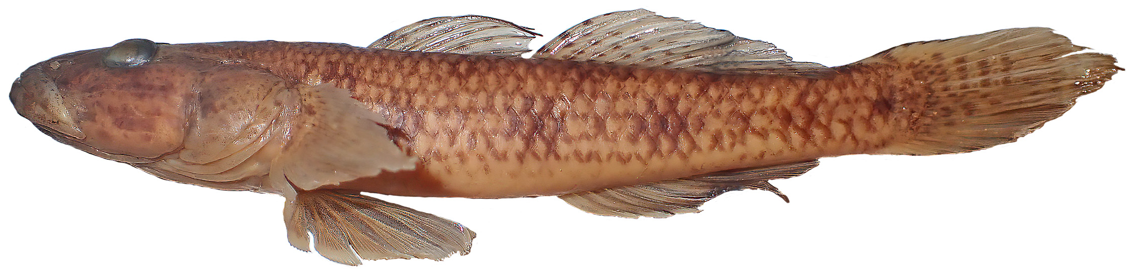
Coloration in preservative: Coloration in alcohol is generally similar to that of freshly collected specimens, except that the dark spots and stripes fade. Specimens stored in alcohol for long periods (>30 years) are often very faded, but the general patterns are usually discernible ( Figures 16–29 View FIGURE 16 View FIGURE 17 View FIGURE 18 View FIGURE 19 View FIGURE 20 View FIGURE 21 View FIGURE 22 View FIGURE 23 View FIGURE 24 View FIGURE 25 View FIGURE 26 View FIGURE 27 View FIGURE 28 View FIGURE 29 , 30b View FIGURE 30 ). Figure 30 View FIGURE 30 illustrates fading in a specimen over a period of 33 years. Examination of material over 100 years suggests that the basic spotting patterns can fade completely. Preserved specimens from Bangladesh, South Africa and Madagascar have similar coloration to Australian specimens ( Figures 25–29 View FIGURE 25 View FIGURE 26 View FIGURE 27 View FIGURE 28 View FIGURE 29 ).
Distribution: In Australia the species is known from rivers of the Hammersley Ranges and the Kimberley Region of Western Australia and eastward to the Northern Territory. We have examined specimens from Madagascar, South Africa, India, Bangladesh and Malaysia. In addition genetic samples indicate the species is known also from Vietnam and China (mitochondrial lineage giuris B in Hammer et al. in press). In Australia it is sympatric with G. laticeps only in the Daly river system of the Northern Territory.
Similarity to other species: Glossogobius giuris is similar to G. aureus and G. circumspectus in general appearance and poorly developed mental fraenum covered with sensory papillae. Glossogobius giuris differs from G. circumspectus in having fewer gill rakers (1–2+1+7–10 = 9–12 versus usually 2–3+1+10–12 = 13–16) and in having a multiple longitudinal papilla pattern (vs. transverse pattern in adults) and in larger midlateral dark spots. The papilla patterns are similar in the two species in specimens below 60 mm SL. Glossogobius giuris differs from G. aureus in having cheek papilla line 6 and in having a shorter snout and fewer predorsal scale (14–23, usually 18–20 in Australia versus 23–38 in aureus ).
The species is most similar to G. laticeps , differing in several minor features including, fewer opercular scales, usually not reaching past middle of operculum, fewer pectoral base scales, usually not reaching bases of pectoral fin-rays, short and broader gill rakers, predorsal scales usually not reaching to posterior orbital pore, lack of distinct black margins to sides of the chin and a more slender body. The species typically has a dark grey band along just below the distal margin of the first dorsal fin or black tips to the first dorsal spines; the distal black pigment is absent in G. laticeps . The species differs slightly from G. laticeps in having few opercular scales in 2–3 rows (sometimes absent in specimens below 50 mm SL and some populations in Western Australia), confined to anterodorsal region (vs. 4–6 rows covering most of dorsal region), a uniformly gray or brown chin, juveniles and young adults with black along distal margin of first dorsal fin and few or no brown stripes on side of body.
Variation: The sensory papillae increase with size. Some juveniles below 35 mm SL only have each papilla line composed of a single row of papillae ( Figure 14 View FIGURE 14 ). Considerable localised variation was noted in this species, particularly in the Kimberley Region of Western Australia. The overall body colour can vary considerably from dark to very light brown. The maximum size of specimens collected from the Maitland River in Western Australia from 1969 to 1977 is a larger size than specimens from other Australian populations and many of the specimens show abnormal head pore development, often with multiple interorbital pores. Specimens from the Drysdale River, Western Australia also show a high degree of abnormalities in the head canals, with large head pores, particularly in the interorbital regions, extra pores along the lateral canal and incomplete development along the lateral and preopercular canals. In one sample, collected in 1985 (AMS I.25532-002), only 20% of the specimens had normally developed head canals and pores. A lower percentage of abnormalities (with 87% having normally developed canals and pores) were also noted in specimens from the Drysdale in 1977 (AMS I.20403-006). Extra interorbital pores (usually paired anterior interorbital pores) were found in 49 of 50 specimens from the Maitland River, 15 of 30 from the Fortescue River and 16 or 38 from the Ashburton River. Specimens from the Maitland and Fortescue River System have a higher proportion of specimens with one fewer second dorsal ray (27% of specimens versus 4% in samples from other localities). Opercular scales show considerable variation in the Kimberley Region. Specimens often have few or no opercular scales. Specimens from South Africa, Madagascar and Bangladesh generally have opercular scales showing little variation, covering the upper half or less of the operculum. Populations in the Hamersley Ranges and Kimberley regions also show significant variation in means of pectoral fin ray counts (p<.001, Table 1 View TABLE 1 ) and predorsal scales (p<.002, Table 2 View TABLE 2 ). The separation of the interorbital canal pores with asymmetrical pores in some populations has relevance to recognition of G. aureus and G. koragensis . Hoese & Allen (2015) noted that the main difference between the two species was the separation of the head canal between the eyes in G. koragensis . Genetic evidence from mitochondrial DNA (Hammer, et al. in press) also suggests that southern material ( Australia and New Guinea) identified as G. aureus represents a distinct mitochondrial lineage to that from Southeast Asia, with Sepik River material agreeing with Australian material. Consequently, it is likely that the Australian and New Guinea populations may take the name G. koragensis , with the abnormal head canal system variation due to an unknown factor in some river systems. Nuclear genetic studies would again be valuable to help guide this assessment; e.g. phenomena such as mitochondrial replacement is relatively common in closely related freshwater fishes and can mask actual species level splits.
Some specimens from the Ord River (NTM S.17624-003) in Western Australia differ slightly from specimens from other populations. The specimens are very fat and deep bodied, and the chin is dark, but slightly darker at the edges and easily mistaken for G. laticeps . The opercular scales are few as in other specimens of G. giuris . Specimens from the Ord River also average higher pectoral ray counts than in other populations (modally 20 versus 18–19). Hoese & Allen (2012) reported increases in branching of caudal rays in Glossogobius munroi from usually 12 below 40 mm SL to 13–14 in larger adults. We found no trend in branched caudal rays in 58 specimens examined from 37–141 mm SL.
Remarks: Examination of the urogenital papilla indicates that specimens from Australia are probably mature at around 60–100 mm SL, and the largest specimens examined in this study was 185 mm SL. Males with bright fin coloration and prolonged second spine of first dorsal fin, suggesting breeding condition are known from individuals as small as 60 mm SL ( Figure 15 View FIGURE 15 ). Some Kimberley populations are known to complete their lifecycle wholly in freshwater by virtue of their presence above major waterfalls.
Common Names. In Australia several names have been used including Tank Goby, Flathead Goby, Ganges Goby, with Indigenous language names including Wuma minya (Belaa), Nyagooma (Bunuba), Thamarli (Gooniyandi), Ngagulnun (Ngarinyin), Joolany (Nyikina), Luju (Walmajarri) and Munin (Wardaman). Numerous other names are used in other languages (see Fishbase.org). We have informally referred to the species as the Inland Tank Goby, relating to its habitat and distribution in Australia.


No known copyright restrictions apply. See Agosti, D., Egloff, W., 2009. Taxonomic information exchange and copyright: the Plazi approach. BMC Research Notes 2009, 2:53 for further explanation.
|
Kingdom |
|
|
Phylum |
|
|
Class |
|
|
Order |
|
|
Family |
|
|
Genus |
Glossogobius giuris ( Hamilton, 1822 )
| Hoese, Douglass F. & Hammer, Michael P. 2021 |
Glossogobius giuris
| Hammer, M. P. 2018: 170 |
| Pusey, B. J. & Burrows, D. W. & Kennard, M. J. & Perna, C. N. & Unmack, P. J. & Allsop, Q. & Hammer, M. P. 2017: 73 |
| Morgan, D. L. & Allen, G. R. & Pusey, B. J. & Burrows, D. W. 2011: 18 |
| Morgan, D. L. 2010: 363 |
| Allen, G. R. & Midgley, S. H. & Allen, M. 2002: 268 |
| Larson, H. K. & Martin, K. C. 1990: 66 |
| Allen, G. R. 1989: 205 |
| Merrick, J. R. & Schmida, G. E. 1984: 311 |
| Allen, G. R. 1982: 66 |
| Lake, J. S. 1978: 73 |
Gobius giuris
| Hamilton, F. 1822: 50 |