
Abrahamia turkii Randrian. & Lowry, 2017
|
publication ID |
https://doi.org/ 10.5281/zenodo.7618113 |
|
DOI |
https://doi.org/10.5281/zenodo.7615561 |
|
persistent identifier |
https://treatment.plazi.org/id/038887C6-FF41-FF59-FE43-83651A9D0F39 |
|
treatment provided by |
Carolina |
|
scientific name |
Abrahamia turkii Randrian. & Lowry |
| status |
sp. nov. |
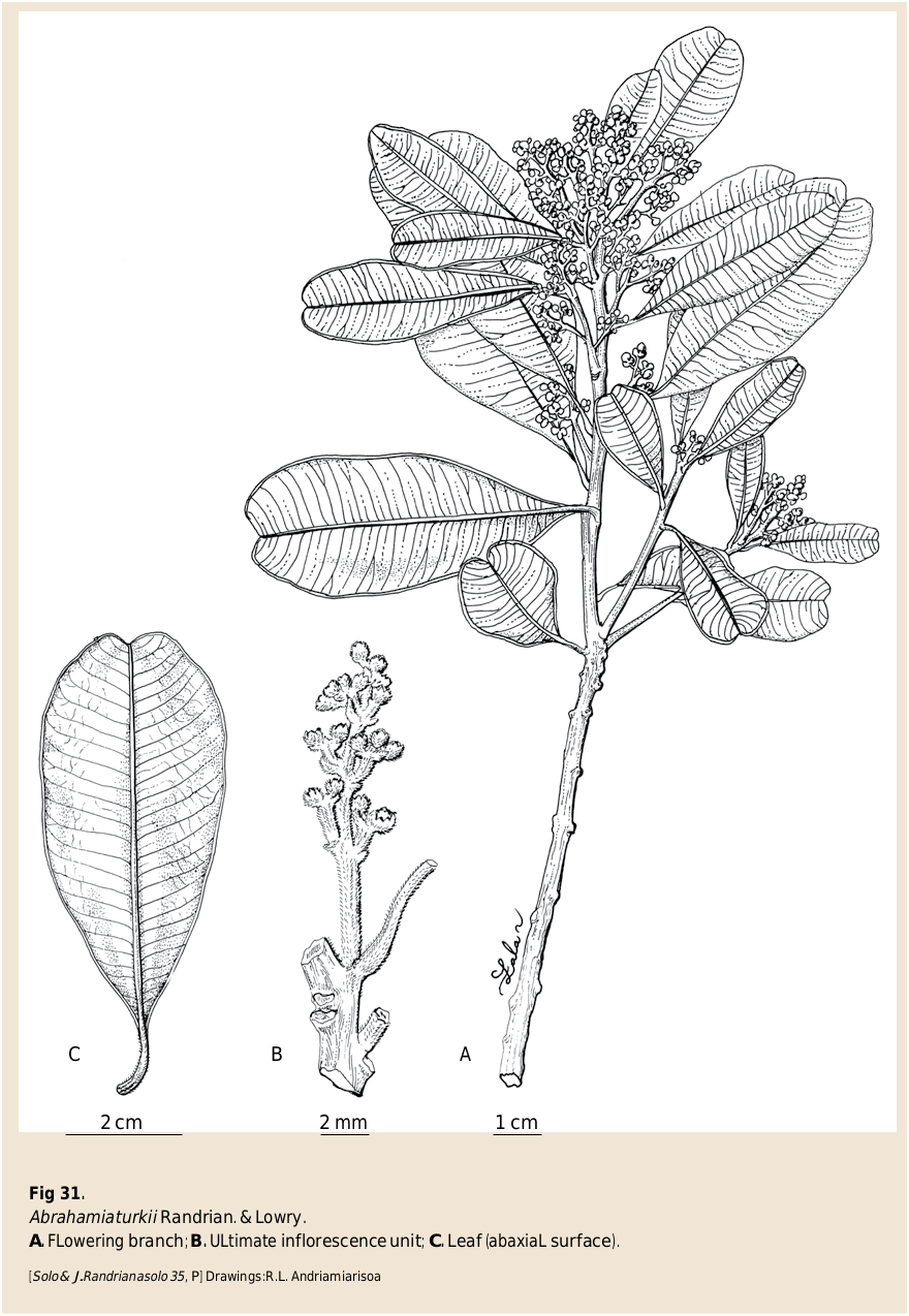
33. Abrahamia turkii Randrian. & Lowry View in CoL , spec. nova ( Fig. 31 View Fig ).
Typus: MADAGASCAR. Prov. Fianarantsoa: Rég. Vatovavy-Fitovinany , Ranomafana National Park, parcelle 3, S of National road 25 at 7 km W of Ranomafana, Talatakely trail system, 21°15’30’’S 47°25’00’’E, 950-1150 m, 20.X.1993, fl., Solo & J. Randrianasolo 35 (holo-: MO- 6671437 !; GoogleMaps iso-: G, K, MO- 6671438 !, P [ P06168911 ]!, TAN [ TAN002002 View Materials ]!, WAG). GoogleMaps
Diagnosis
Abrahamia turkii Randrian. & Lowry can be distinguished from other members of the genus by its coriaceous leaves, inflorescence with thick axes and ferruginous indument, and fruits that are small in size (1.8-2 3 1 cm) and glabrous.
Description
Trees 11-30 m tall, 18-100 cm DBH, bark with white latex; young twigs sericeous on tips, lenticellate farther from the tip. Leaves usually alternate, sometimes subopposite; blade obovate, 2.5-8 3 1.5-3.5 cm, coriaceous, apex usually emarginate or retuse, sometimes rounded, margin slightly revolute, sometimes undulate, base cuneate, adaxial surface sparsely pubescent, abaxial surface sericeous or strigose, venation craspedodromous, midvein prominent abaxially, secondary veins 14-24 pairs, 1-4 mm apart, raised on both surfaces, tertiary veins visible on both surfaces; petiole 0.5-1 cm long, 1-1.5 mm in diam., pubescent or scabrous, canaliculate on adaxial surface. Inflorescence axillary or terminal, a panicle, erect, axes thick, 1-5 cm long, reddish brown pubescent. Male flowers 5-merous, c. 3-4 mm long; pedicel c. 0.3-0.5 mm long, reddish brown pubescent; calyx lobes triangular, 1.5-2 3 1-2 mm, adaxial surface glabrous, abaxial surface, pubescent; corolla lobes ovate, 2-4 3 2 mm, adaxial surface glabrous, abaxial surface pubescent; stamens 5, filament 1-2 mm long, glabrous, anthers 1 mm long, ovoid to obloid, glabrous; disk slightly cupuliform, c. 2 mm in diam., glabrous; ovary very rudimentary or absent. Female flowers unknown. Fruits 1.8-2 3 1 cm, ovoid, glabrous, wrinkled when dry (longitudinal striations not as evident as in other species).
Distribution, ecology and phenology
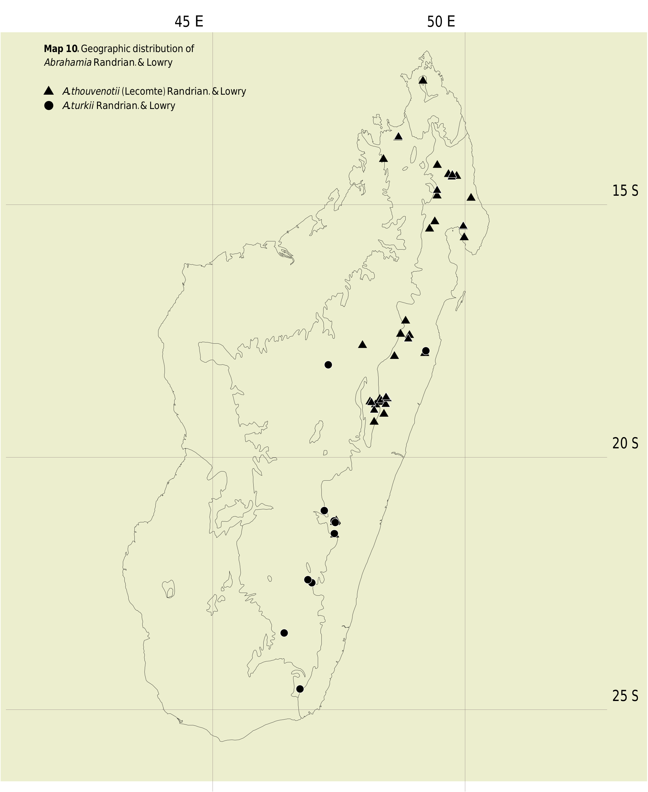
Abrahamia turkii is distributed mainly in south-central and southern Madagascar, although one collection has been made at the Ambohitantely forest, far to the north of the other recorded subpopulations ( Map 10 View Map 10 ). Flowering material has been recorded in October and November, and fruits have been collected in January.
Conservation status
With an EOO of 85,992 km 2, a minimum AOO of 40 km 2 but an estimated value well exceeding 2,000 km 2, and 9 localities, with subpopulations in 6 protected areas (Ambohitantely, Andohahela, Betampona, Kalambatritra, Pic d’Ivohibe, and Ranomafana), representing 9 locations, only some of which may be subjected to pressure from forest exploitation and land clearing, A. turkii is assigned a preliminary conservation status of “Least Concern” [LC] using the IUCN Red List Categories and Criteria ( IUCN, 2012).
Notes
Abrahamia turkii closely resembles A. ditimena by its medium sized, coriaceous leaves with craspedodromous venation, usually emarginate or retuse apex, and tertiary venation that is visible on both surfaces, and its paniculate inflorescence, but it can easily be distinguished by its short (1-5 vs 2-10 cm) inflorescence covered with reddish brown pubescence (vs glabrescent or tomentose), and its glabrous (vs velutinous) fruits.
Paratypi
MADAGASCAR. Prov. Antananarivo: forêt d’Ambohitantely, 18 km NW of Ankazobe, [18°10’S 47°18’E], 1400-1646 m, 21.XI.1985, bud, Barnett et al. 533 ( MO, P, TAN). GoogleMaps Prov. Fianarantsoa: Ivohibe RS, piste II et III, 22°29’00’’S 46°58’06’’E, 1275 m, 20.X.1997, fl., Rakotomalaza et al. 1434 ( G, MO, P, TAN); GoogleMaps Ivohibe RS, 5.5 km SE d’Angondongodona, camp 4, 22°25’18’’S 46°53’54’’E, 1150 m, 4.XI.1997, fl., Rakotomalaza et al. 1494 ( G, K, MO, P, TAN); GoogleMaps Haute Matsiatra, Ialatsara forest, 21°03’07’’S 47°12’42’’E, 12.X.2005, fl., Ranarivelo et al. 719 ( CAS, MO); GoogleMaps Ranomafana PN, parcelle 3, Vatoharana trail system, 21°17’S 47°26’E, 1100-1250 m, 18.XI.1993, fl., Turk & J. Randrianasolo 585 ( G, MO, P, TAN); GoogleMaps Andrambovato , E de Fianarantsoa, [21°31’S 47°25’E], 878-1000 m, 24.I.1955, fr., Service Forestier 11590 ( G, MO, P, TEF). GoogleMaps Prov. Toamasina: RN1 [Betampona], s.d., fl. & y. fr., Anonymous s.n. ( G, MO, P [2 sheets]). GoogleMaps Prov. Toliara: Betroka , Kalambatritra RS, forêt d’Analamaro, 23°28’28’’S 46°25’15’’E, 1423 m, 9.I.2004, fl., Andrianjafy et al. 601 ( MO, P, TAN); GoogleMaps Andohahela PN, parcelle 1, 13.5 km NW d’Eminiminy, 24°35’S 46°44’1’’E, 1200 m, 15.XI.1995, fl., Messmer et al. 105 ( G, MO) GoogleMaps .
| WAG |
WAG |
| CAS |
USA, California, San Francisco, California Academy of Sciences |
| TEF |
TEF |
| G |
Conservatoire et Jardin botaniques de la Ville de Genève |
| K |
Royal Botanic Gardens |
| P |
Museum National d' Histoire Naturelle, Paris (MNHN) - Vascular Plants |
| TAN |
Parc de Tsimbazaza |
| WAG |
Wageningen University |
| MO |
Missouri Botanical Garden |
| CAS |
California Academy of Sciences |
| TEF |
Centre National de la Recherche Appliquée au Developement Rural |
No known copyright restrictions apply. See Agosti, D., Egloff, W., 2009. Taxonomic information exchange and copyright: the Plazi approach. BMC Research Notes 2009, 2:53 for further explanation.
|
Kingdom |
|
|
Phylum |
|
|
Class |
|
|
Order |
|
|
Family |
|
|
Genus |