
Afrocyclus isipingoensis ( Sturany, 1898 ) Cole, 2019
|
publication ID |
https://doi.org/ 10.5852/ejt.2019.569 |
|
publication LSID |
lsid:zoobank.org:pub:79BE13FC-B840-4C39-8D25-3328BDCC44D2 |
|
persistent identifier |
https://treatment.plazi.org/id/101687E3-D56C-FF8A-FE40-A8BCFC3ED2A0 |
|
treatment provided by |
Plazi |
|
scientific name |
Afrocyclus isipingoensis ( Sturany, 1898 ) |
| status |
gen. et comb. nov. |
Afrocyclus isipingoensis ( Sturany, 1898) View in CoL gen. et comb. nov.
Figs 27 View Fig , 28A View Fig , 29 View Fig
Cyclotus isipingoensis Sturany, 1898: 161 (type loc.: Isipingo [Penther]).
Cyclophorus minimus Melvill & Ponsonby, 1898: 129 , pl. vii, fig. 9 (type loc.: Pietermaritzburg [Burnup]).
Cyclophorus (Maizania) isipingoensis – Kobelt 1902: 149 .
Chondrocyclus isipingoensis – Connolly 1939: 540 View in CoL . — Herbert & Kilburn 2004: 91.
Cyclophorus minimus – Melville & Ponsonby 1899 : pl. iii, fig. 15 (operculum).
Diagnosis
Shell very small, very depressed, discoidal; periostracum with axial costae producing spiral rows of simple hairs; operculum very fragile and duplex, exterior portion very shallowly concave, with low multispiral lamella terminating in a solid fringe; rachidian tooth of radula with serrated upper edge, two large cusps on second lateral tooth.
Etymology
Named after the type locality, Isipingo, KwaZulu-Natal, South Africa.
Type material examined
Holotype
SOUTH AFRICA – KwaZulu-Natal • holotype of Cyclotus isipingoensis Sturany, 1898 ; in Vienna Museum, not examined; NHMW.
Syntype
SOUTH AFRICA – KwaZulu-Natal • syntype of Cyclophorus minimus Melvill & Ponsonby, 1898 ; Pietermaritzburg; Burnup leg.; NHMUK 1902.10 View Materials .1.7 .
Other material examined
SOUTH AFRICA – Limpopo • 99 specimens; Soutpansberg, Dundee Forest ; 23.017° S, 29.515°E; 24 Jul. 1999; C. Symons leg.; sorted from leaf litter; NMSA V7513 View Materials GoogleMaps • 77 specimens; Soutpansberg, Entabeni, Goedehoop , indigenous forest; 23.0833° S, 30.1117°E; ± 950 m a.s.l.; 20 Nov. 1997; D. Herbert leg.; in leaf-litter; NMSA V5658 View Materials GoogleMaps . – Mpumalanga • 119 specimens; Buffelskloof Nat. Res. , indigenous forest; 25.3169° S, 30.4990°E; 1300 m a.s.l.; 15 Mar. 2006; J. Horn leg.; in leaf-litter; NMSA W4486 View Materials GoogleMaps . – KwaZulu-Natal • 28 specimens; Ngoye Forest , lower section, coastal scarp forest; 28.8330° S, 31.7170° E; ± 250 m a.s.l.; 6 Sep. 1997; D. Herbert leg.; in leaf litter; NMSA V5861 View Materials GoogleMaps • 6 specimens; Nkandla Forest Reserve, Mdonini area , mist-belt forest; 28.7453° S, 31.1357° E; ± 1050 m a.s.l.; 21 Oct. 2003; Herbert, Bursey and Nangammbi leg.; under logs and in leaf-litter; NMSA W 1103 View Materials GoogleMaps • 58 specimens; Vernon Crookes Nat. Res. , small patch of scarp forest; 30.2750°S, 30.5830° E; 1 Jan. 2004; D. Herbert leg.; in thin layer of leaf-litter on flat-topped boulder; NMSA W1441 View Materials GoogleMaps • 28 specimens; Loteni, Yellow-Wood Cave area montane Podocarpus forest; 29.4150°S, 29.4800°E; 1800 m a.s.l.; in leaf-litter; 25 Oct. 1997; D. Herbert leg.; NMSA V5752 View Materials GoogleMaps • 30 specimens; Karkloof Falls, near top of gorge, Southern Mistbelt Forest ; 29.4088° S, 30.2840°E; 22 Jan. 2010; M. Cole leg.; ELM D16902 GoogleMaps • 3 specimens; same collection data as for preceding; ELM W03650 GoogleMaps • 1 specimen; Karkloof Nature Reserve ; 29.3150° S, 30.2500° E; 1350 m a.s.l.; 23 Jan. 2010; M. Cole leg.; ELM D16903 GoogleMaps • 17 specimens; Kenneth Stainbank N.R, Yellowwood Park ; 29.9122° S, 30.9390°E; 12 Jan. 2010; M. Cole and K. Cole leg.; ELM D16897 GoogleMaps • 34 specimens; same collection data as for preceding; 12 Apr. 2011; M. Cole, R. Daniels, L. Davis and D. Herbert leg.; ELM D16898 GoogleMaps • 1 specimen; same collection data as for preceding; ELM W03648 GoogleMaps • 3 specimens; same collection data as for preceding; NHMUK 20120268 View Materials GoogleMaps • 2 specimens; same collection data as for preceding; NMW.Z.2012.065.00001 GoogleMaps • 1 specimen; Kranskop area, Ntumjambili , indigenous forest; 28.9380°S, 30.9550°E; ± 900 m a.s.l.; 9Aug. 1997; D. Herbert leg.; in leaf-litter; NMSA V5105 View Materials GoogleMaps • 3 specimens; Kelso , dune forest behind railway station; 30.3622°S, 30.71316° E; 24 m a.s.l.; 31 Oct. 2010; M. Cole leg.; ELM D17635 GoogleMaps . – Eastern Cape • 2 specimens; Mtentu , north bank, inlet 1.5 km upstream to first waterfall from mouth, east side of inlet; 31.2389°S, 30.0340° E; 30 m a.s.l.; 13 Jan. 2012; M. Cole leg.; ELM D17086 GoogleMaps • 1 specimen; same collection data as for preceding; ELM W03604 GoogleMaps • 1 specimen; Mtentu , north bank, inlet 3 km upstream of mouth, west side of inlet; 31.2295°S, 30.0182° E; 43 m a.s.l.; 12 Jan. 2012; M. Cole leg.; ELM D17006 GoogleMaps • 1 specimen; same collection data as for preceding; ELM W03605 GoogleMaps • 7 specimens; Mkambati Nature Reserve, between Mkambati and Strandloper Falls , forest on east bank of Mkambati River ; 31.2738° S, 30.0236°E; 15 Feb. 2011; M. Cole leg.; ELM D16913 GoogleMaps • 5 specimens; same collection data as for preceding; ELM W03653 GoogleMaps • 3 specimens; Mkambati, east bank Msikaba mouth; 31.3183° S, 29.9683° E; 16 Feb. 2011; M. Cole leg.; ELM D16914 GoogleMaps • 1 specimen; Mkambati, Gwe Gwe forest, forest above Gwe Gwe cottages; 31.2904°S, 29.9897°E; 5 Mar. 2001; M. Cole leg.; ELM D17004 GoogleMaps • 1 specimen; Mkambati Nature Reserve, Daza forest ; 31.3025° S, 29.9767°E; 16 Feb. 2011; M. Cole leg.; ELM W03688 GoogleMaps • 2 specimens; Mbotyi, Ntsubane Forest, inland of coast, accessed along KwaNyambalala River ; 31.4615° S, 29.7129°E; 3 Mar. 2003; M. Bursey leg.; ELM D17363 GoogleMaps • 2 specimens; Xora, Kumqolo Forest, west bank of Xora river opposite Mangrove swamp; 32.1589° S, 28.9848° E; 13 Aug. 2011; M. Cole leg.; ELM D17584 GoogleMaps • 5 specimens; Qora, East Bank of Qora River , riverine forest; 32.4333° S, 28.6667° E; 7 Nov. 2009; M. Cole leg.; ELM D16904 GoogleMaps • 1 specimen; same collection data as for preceding; ELM W03651 GoogleMaps • 1 specimen; same collection data as for preceding; 9 Oct. 2011; M Cole leg.; ELM D17000 GoogleMaps • 17 specimens; Phumalanga Farm, 7 km inland of Cintsa, riverine forest on Bulura River ; 32.8067° S, 28.0306°E; 25 Apr. 2006; Bursey, Wigley and Ndibo leg.; ELM D15030 GoogleMaps • 12 specimens; same collection data as for preceding; 12 Dec. 2008; M. Wigley; ELM D15870 GoogleMaps • 23 specimens; same collection data as for preceding; 16 Nov. 2009; M. Cole and M. Wigley leg.; ELM D16899 GoogleMaps • 19 specimens; same collection data as for preceding; 1 Dec. 2009; M. Wigley; ELM D16900 GoogleMaps • 11 specimens; same collection data as for preceding; ELM W03686 GoogleMaps • 51 specimens; same collection data as for preceding; 31 Dec. 2010; M. Cole leg.; ELM D16901 GoogleMaps • 9 specimens; same collection data as for preceding; ELM W03649 GoogleMaps • 1 specimen; Umtiza Nature Reserve, Tree Dassie trail on east side of Buffalo Pass ; 33.0169° S, 27.8092°E; 21 Apr. 2006; M. Bursey leg.; ELM W03008 GoogleMaps • 3 specimens; same collection data as for preceding; 8 Jun. 2010; M. Cole leg.; ELM D16905 GoogleMaps • 8 specimens; same collection data as for preceding; 13 Jan. 2011; V. Ndibo, J. Glatz and R. Daniels leg.; ELM D16906 GoogleMaps • 5 specimens; same collection data as for preceding; ELM W03652 GoogleMaps • 5 specimens; same collection data as for preceding; 20 May 2011; M. Cole leg.; ELM D16907 GoogleMaps • 7 specimens; same collection data as for preceding; 18 Mar. 2011; M. Cole leg.; ELM D16908 GoogleMaps • 1 specimen; same collection data as for preceding; 1 Dec. 2011; M. Cole leg.; ELM D16909 GoogleMaps • 1 specimen; Hogsback, downstream of Madonna and Child Waterfall ; 32.6068°S, 26.9622° E; 1060 m a.s.l.; 25 Jan. 2002; M. Bursey leg.; ELM W02835 GoogleMaps • 1 specimen; Hogsback, Amathole Mountains, Kettlespout , forest above Hobbiton ; 32.5667° S, 26.9167° E; 31 Dec. 2008; M. Cole leg.; ELM D17007 GoogleMaps • 10 specimens; Amathole Mountains, Stutterheim, Kologha Forest , near picnic site, Southern Mistbelt forest ; 32.5339° S, 27.4308° E; 22 Dec. 2009; M. Cole leg.; ELM D16910 GoogleMaps • 2 specimens; Stutterheim, Kologha Forest, forest drive near Protea Hill ; 32.5339° S, 27.4308°E; 26 Jan. 2010; M. Cole leg.; ELM D16911 GoogleMaps • 3 specimens; Stutterheim, Contour path; 32.5366°S, 27.3668°E; 16 Jan. 2015; M. Cole leg.; ELM D17873 GoogleMaps • 2 specimens; Maden Dam, 18 km N.W. of King Williams Town ; 32.7333° S, 27.2833°E; 26 Mar. 2011; D.-J. Hodgkinson leg.; ELM D16912 GoogleMaps • 9 specimens; Fort Fordyce , kloof with watercourse and sheer krantz; 32.6893°S, 26.5121° E; 915 m a.s.l.; 29 Dec. 2008; M. Cole leg.; ELM D16916 GoogleMaps • 2 specimens; same collection data as for preceding; 6 Oct. 2009; M. Cole leg.; ELM D16961 GoogleMaps .
Description
Specimens from Kenneth Stainbank Nature Reserve, Durban, approx. 9 km from the type locality Isipingo, are considered to represent the type in the following description.
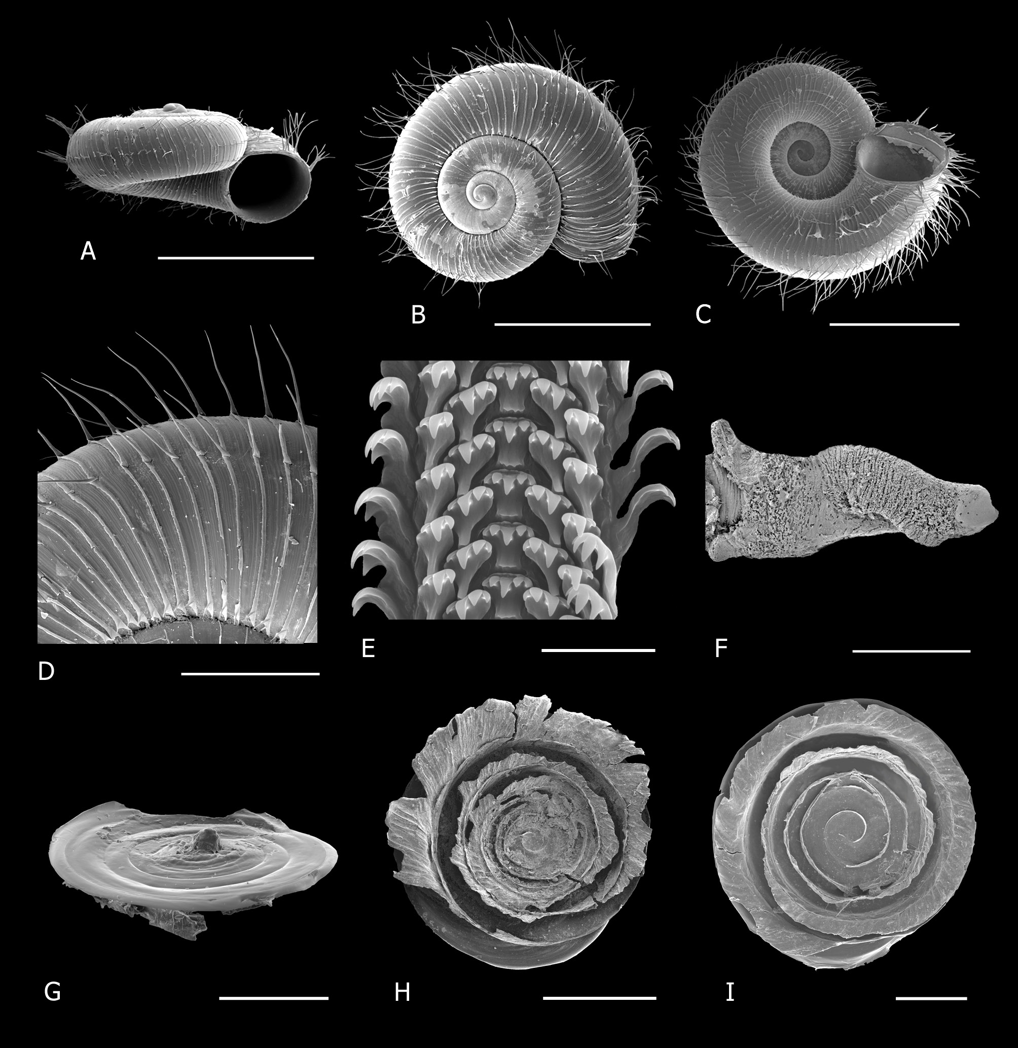
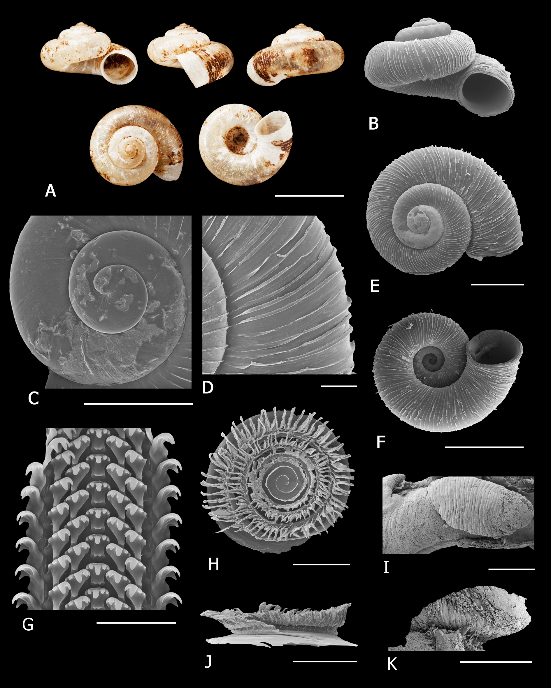
SHELL ( Fig. 27 View Fig A–C). Very small, very depressed, discoidal, adult diameter 2.24–3.67 mm, height 1.09– 1.67 mm, diameter:height 1.9–2.31 (n = 16) Spire almost flat, sometimes concave, usually with only the weakly mammillate, slightly tilted protoconch projecting ( Fig. 27A View Fig ). Embryonic shell ( Fig. 28A View Fig ) approx. 2.25 whorls, microscopically malleate for approx. two whorls, axial costae begin to develop at about 2.25 whorls. Teleoconch comprising just over two whorls, very rapidly increasing, convex, suture impressed. Aperture circular, last whorl descending steeply nearing aperture, peristome simple, continuous and free. Umbilicus very wide, exposing all the whorls ( Fig. 27C View Fig ). Periostracum glossy and lacquer-like with lamellate well-spaced axial costae at regular intervals, the average number on last whorl varying between 55 and 92 ( Table 5), which produce 10–12 spiral rows of simple hairs, longest at periphery (four rows) with approx. five–seven rows between periphery and umbilicus, the latter becoming progressively shorter nearer the umbilicus, and one very short row immediately below the suture; intervals between costae usually with six to nine microscopic axial threads ( Fig. 27D View Fig ). Shell translucent when fresh.
OPERCULUM ( Fig. 27 View Fig E–F). Very fragile and duplex, outer portion consists of multispiral lamella with five–six whorls, height of lamellar blade very low thus operculum is very shallowly concave to almost flat, thickened horizontal ridge on lamellar blade just above disc surface; long fringe of fused bristles emanates from this ridge, fused to blade and then curving outwards, leaving no furrow between fringe and vertical portion of blade, fringe of each whorl fused to lamella of following whorl, fringe of outer whorl fairly long and overlaps disc slightly; inner portion of operculum is a thin disc, in some populations side of disc facing body has a prominent tubercle or swelling in centre ( Fig. 27F View Fig ).
RADULA ( Fig. 27G View Fig ). Rachidian with five cusps, central one very long, outermost two very small to almost vestigial, cusps set a little distance below ‘top’ of tooth, top edge serrated; first lateral tooth with four cusps and a vestigial fifth, third cusp (from centre) largest; second lateral tooth with two large cusps, second cusp (from centre) largest, a third small cusp and a vestigial fourth.
PENIS ( Fig. 27H View Fig ). Shaft more or less cylindrical and laterally expanded on left side about midway down the shaft.
Distribution and habitat
This species complex is widely distributed throughout the eastern region of South Africa, from Soutpansberg mountains in Limpopo Province to the Amathole mountains in the Eastern Cape; from the coast to the Drakensberg foothills (1800 m) ( Fig. 29 View Fig ).
Indigenous forest of several classification types ( Mucina & Geldenhuys 2006): Southern and Northern Coastal Forest, Scarp Forest, Southern and Northern Mistbelt Forest, Northern Afrotemperate Forest, and Albany Thicket (Kowie Thicket) ( Hoare et al. 2006); in leaf-litter.
Remarks
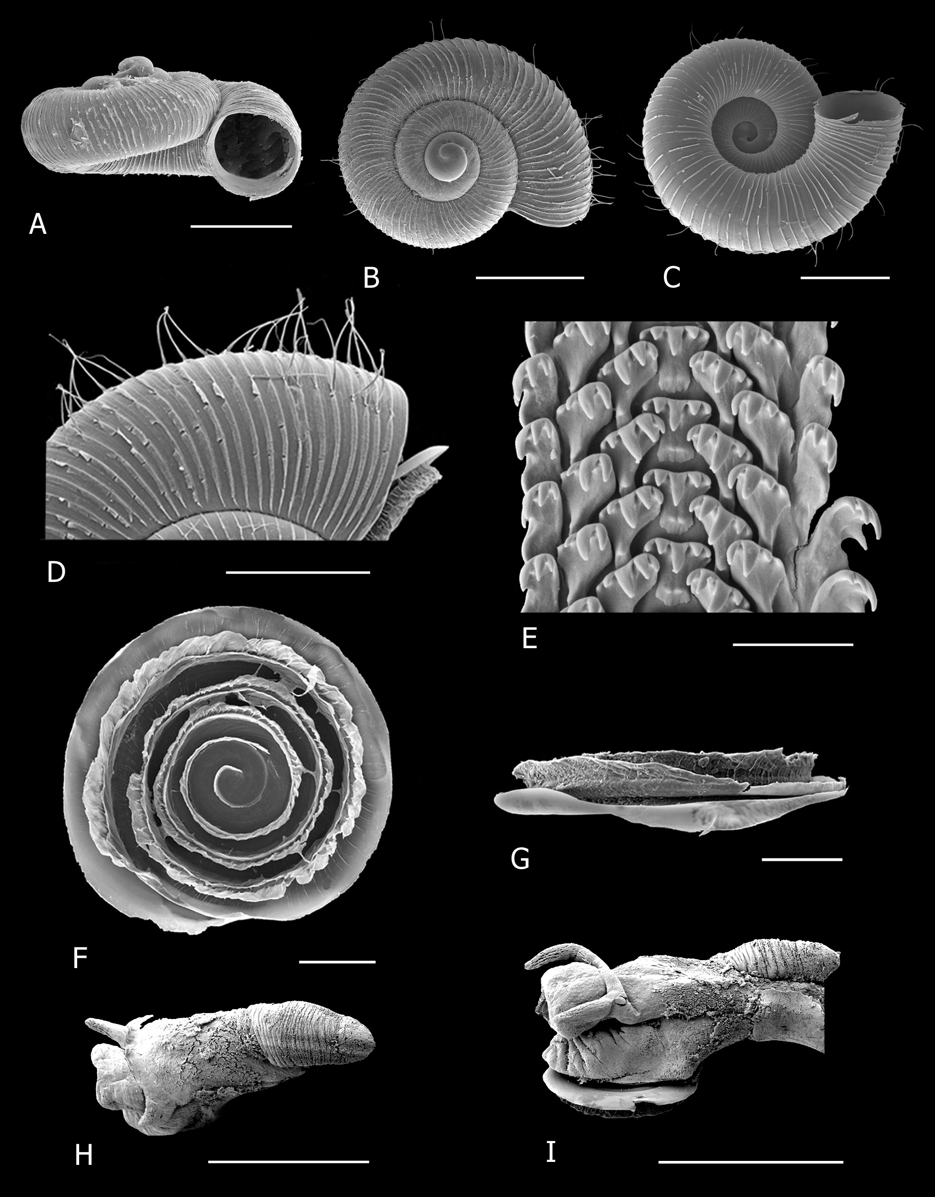
Selected populations from across the range of this lineage were sampled for the molecular study and morphological examination and there is compelling evidence that A. isipingoensis gen. et comb. nov. is a species complex rather than one widespread species. Until further study is undertaken the name A. isipingoensis gen. et comb. nov. is applied to all populations with the exception of the three new species described below. Differences in the density of axial lamellae, the number and position of spiral rows of hairs, the length of the hairs, the density of microscopic axial threads between the lamellae and the strength of protoconch sculpture will need to be evaluated in conjunction with molecular evidence from more comprehensive coverage of the range of the complex.
The phylogeny inferred suggests that populations from the western end of the range (Somerset East and Bedford) belong to a distinct lineage ( A. oxygala gen. et sp. nov.). There was also a well-supported lineage in montane areas between the coast and Great Escarpment in the central Transkei ( A. potteri gen. et sp. nov.) and another lineage occurring in relatively close proximity in the north-eastern Transkei ( A. bhaca gen. et sp. nov.). The population from near the type locality had one row of extremely short hairs on lamellate costae immediately below the suture, and a gap with no hairs between this and the four rows of very long hairs near the periphery ( Fig. 27D View Fig ). Afrocyclus oxygala gen. et sp. nov. ( Fig. 30D View Fig ), A. potteri gen. et sp. nov. ( Fig. 31 View Fig D–E) and A. bhaca gen. et sp. nov. ( Fig. 32D View Fig ) lacked the extremely short row just below the suture.
The rachidian tooth of the radula is unusual in having a serrated upper edge and the cusps are set a little distance below the ‘top’of tooth. Afrocyclus isipingoensis gen. et comb. nov. ( Fig. 27G View Fig ), A. exsertus gen. et comb. nov. ( Fig. 33G View Fig ), A. potteri gen. et sp. nov. ( Fig. 31G View Fig ) and A. bhaca gen. et sp. nov. ( Fig. 32E View Fig ) showed this feature while the upper edge of the rachidian tooth of A. oxygala gen. et sp. nov. ( Fig. 30G View Fig ) was not serrated as in species of Chondrocyclus s.s.


No known copyright restrictions apply. See Agosti, D., Egloff, W., 2009. Taxonomic information exchange and copyright: the Plazi approach. BMC Research Notes 2009, 2:53 for further explanation.
|
Kingdom |
|
|
Phylum |
|
|
Class |
|
|
Order |
|
|
Family |
|
|
Genus |
Afrocyclus isipingoensis ( Sturany, 1898 )
| Cole, Mary L. 2019 |
Chondrocyclus isipingoensis – Connolly 1939: 540
| Herbert D. & Kilburn D. 2004: 91 |
| Connolly M. 1939: 540 |
Cyclophorus (Maizania) isipingoensis –
| Kobelt W. 1902: 149 |
Cyclotus isipingoensis
| Sturany R. 1898: 161 |
Cyclophorus minimus
| Melvill J. C. & Ponsonby J. H. 1898: 129 |