
Bioramix (Leipopleura) rufipalpis ( Reitter, 1887 )
|
publication ID |
https://doi.org/ 10.11646/zootaxa.4815.1.1 |
|
publication LSID |
lsid:zoobank.org:pub:F30A9496-288F-4815-A8DE-94B1B104E551 |
|
persistent identifier |
https://treatment.plazi.org/id/03EC8100-FFA4-4645-FF19-FD7AACD41E84 |
|
treatment provided by |
Plazi |
|
scientific name |
Bioramix (Leipopleura) rufipalpis ( Reitter, 1887 ) |
| status |
|
Bioramix (Leipopleura) rufipalpis ( Reitter, 1887)
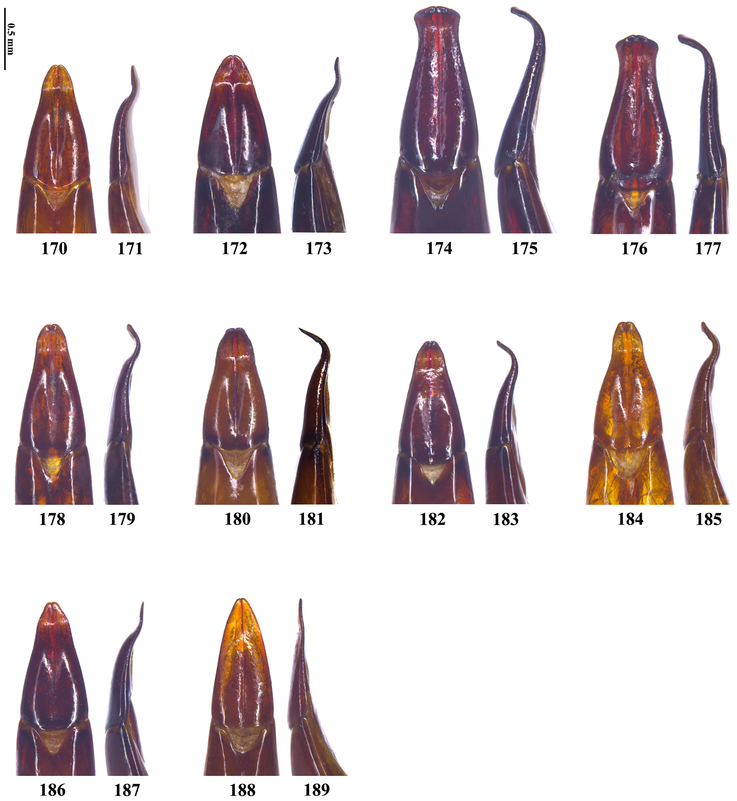
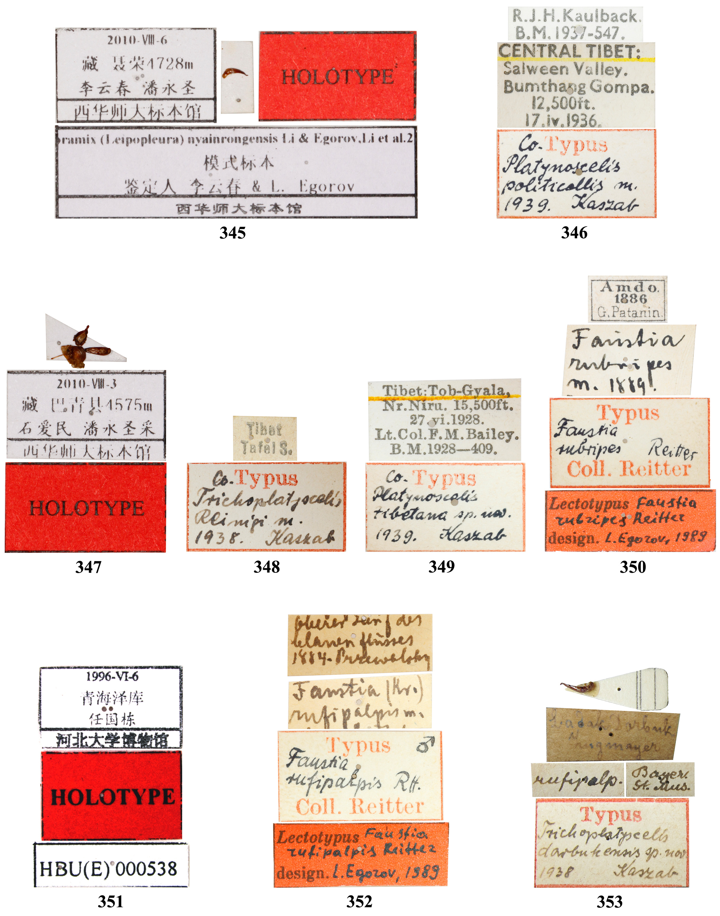
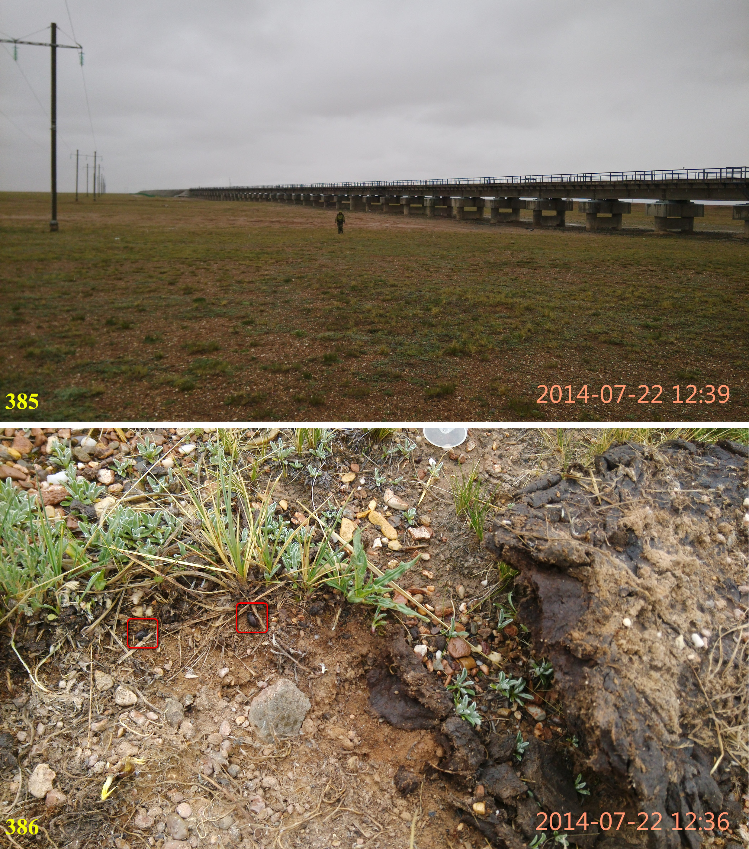
( Figs 174–177 View FIGURES 170–189 , 305–308 View FIGURES 304–309 , 352–353 View FIGURES 345–353 , 386–392 View FIGURES 385–386 View FIGURES 387–392 )
Faustia rufipalpis Reitter, 1887: 383 .
Platyscelis (Leipopleura) rufipalpis: Seidlitz, 1893: 346 .
Platynoscelis (Trichoplatyscelis) rufipalpis: Kaszab, 1940: 159 .
Bioramix (Leipopleura) rufipalpis: Egorov, 1990: 405 ; 2004: 655; 2008: 292; 2009: 63; 2019: 980; Ren & Liu, 2009: 1147 (defensive glands); Li et al., 2016a: 39.
Platynoscelis (Trichoplatyscelis) darbukensis Kaszab, 1940: 160 , syn. n.
Bioramix (Leipopleura) darbukensis: Egorov, 1990: 405 ; 2004: 655; 2008: 292; 2009: 63.
Type material. Lectotype ( Egorov, 1990): ♂ ( HNHM), Oberer Lauf des blauen Flusses, 1884, Przewalsky // Faustia (kr.) rufipalpis m. // Typus, Faustia rufipalpis Rtt., Coll. Reitter // Lectotypus, Faustia rufipalpis Reitter , design. L. Egorov, 1989 ( Figs 305 View FIGURES 304–309 , 352 View FIGURES 345–353 ). Paralectotype: 1♀ ( HNHM), Oberer Fluss des Blauen Flusses, 1884, Przewalsky // Typus, Faustia rufipalpis Reitter // Paralectotypus, Faustia rufipalpis Reitter , design. L. Egorov, 1989. Holotype of Platynoscelis (Trichoplatyscelis) darbukensis Kaszab, 1940 (by monotypy): ♂ ( NMB), Ladak, Darbuk, Zugmay- er // Bayer., St. Mus // rufipalp. // Typus, Trichoplatyscelis darbukensis sp. nov., 1938, Kaszab ( Figs 307 View FIGURES 304–309 , 353 View FIGURES 345–353 ).
Other material. CHINA: Gansu: 2♂♂ ( MHBU), Bayin City , 10.VIII.2009, Guo-Dong Ren et al. leg . Qinghai: 1♀ ( HNHM), Jekundo [Gyêgu Town, Yushu County, Qinghai], Tibet // det. dr. Kaszab ; 1♀ ( IZCAS), Maqên County, 20.VIII.1974, Bing-Wen Li leg. ; 1♀ ( IZCAS), Maqên County, 25.VIII.1974, Bing-Wen Li leg. ; 1♀ ( IZCAS), Zhi- doi County , 13.VI.1979, Ze-Bin Lin leg. ; 58♂♂, 34♀♀ ( MHBU), Budongquan, Suojia Township , Zhidoi County, 35°34.040′ N, 93°58.513′ E, 4674 m, 23.VII.2019, Guo-Dong Ren, Xing-Long Bai, Ya-Lin Li, Ming-Min Ma & He Shi leg. GoogleMaps ; 8♂♂, 6♀♀ ( MHBU), Pukawoma Shan , Zhidoi County, 33°53.264′ N, 95°41.631′ E, 4187 m, 24.VII.2019, Guo-Dong Ren, Xing-Long Bai, Ya-Lin Li, Ming-Min Ma & He Shi leg. GoogleMaps ; 1♂, 1♀ ( IZCAS), Tuotuohe , [Tanggu- lashan Town], [Golmud City], 4520 m, 11.IX.2001, Jun Chen leg. ; 35♂♂, 14♀♀ ( MHBU), Kunlun Shankou, Gol- mud City , 35°35.514′ N, 94°01.932′ E, 4675 m, 24.VII.2012, Guo-Dong Ren et al. leg GoogleMaps .; 2♂♂, 2♀♀ ( MHBU), Kun- lun Shankou , [Golmud City], 35°34.788′ N, 94°01.277′ E, 4677 m, 22.VII.2014, Guo-Dong Ren, Xing-Long Bai & Jun-Sheng Shan leg. GoogleMaps ; 1♂ ( MHBU), Xidatan, Golmud City , 35°50.490′ N, 94°20.708′ E, 3898 m, 24.VII.2012, Guo- Dong Ren et al. leg GoogleMaps .; 2♂♂ ( MHBU), Qumar Bridge, Hoh Xil , 35°19.131′ N, 93°18.920′ E, 4539 m, 22.VII.2014, Guo-Dong Ren, Xing-Long Bai & Jun-Sheng Shan leg. GoogleMaps ; 3♂♂, 1♀ ( MHBU), Tibetan Antelope Rescue Center [also known as Suonandajie Nature Protection Station], [Hoh Xil], 35°25.113′ N, 93°34.682′ E, 4481 m, 22.VII.2014, Guo-Dong Ren, Xing-Long Bai & Jun-Sheng Shan leg. GoogleMaps ; 2♂♂, 4♀♀ ( MHBU), Tuotuohe Protection Station , [Hoh Xil], 34°35.458′ N, 92°44.677′ E, 4654 m, 22.VII.2014, Guo-Dong Ren, Xing-Long Bai & Jun-Sheng Shan leg. GoogleMaps ; 6♂♂, 2♀♀ ( MHBU), Qumahe Town , Qumarlêb County, 34°46.979′ N, 95°02.671′ E, 4325 m, 24.VII.2012, Guo- Dong Ren et al. leg GoogleMaps .; 9♂♂, 6♀♀ ( MHBU), Yugê Township , Qumarlêb County, 34°32.890′ N, 95°23.273′ E, 4146 m, 24.VII.2012, Guo-Dong Ren et al. leg GoogleMaps .; 2♂♂ ( MHBU), Tusongyong Yakou , Qumarlêb County, 35°01.980′ N, 94°18.621′ E, 4418 m, 23.VII.2019, Guo-Dong Ren, Xing-Long Bai, Ya-Lin Li, Ming-Min Ma & He Shi leg. GoogleMaps ; 1♂, 1♀ ( MHBU), Guogelalong Shan , Qumarlêb County, 34°43.772′ N, 95°06.299′ E, 4511 m, 23.VII.2019, Guo-Dong Ren, Xing-Long Bai, Ya-Lin Li, Ming-Min Ma & He Shi leg. GoogleMaps ; 1♂ ( MHBU), Nangqên County, 27–29.VI.2014, Zhi-Jun Zhou leg. ; 1♂ ( MHBU), Namsai Township , Zadoi County, 3–5.VII.2014, Zhi-Jun Zhou leg. ; 1♀ ( MHBU), Gesangxiaozhen , Zadoi County, 32°51.721′ N, 95°23.026′ E, 4043 m, 25.VII.2019, Guo-Dong Ren, Xing-Long Bai, Ya-Lin Li, Ming-Min Ma & He Shi leg. GoogleMaps Xizang: 1♂ ( MHBU), Jieshan Daban , [Sumxi Village, Tungru Town- ship, Rutog County], 9.VII.1974, Ji-Jun Li leg. , coll. IZCAS; 1♀ ( MHBU), Jieshan Daban , [Sumxi Village, Tungru Township, Rutog County], 9.VII.1974, Xiang-Chu Yin leg. , coll. NWIPB; 9♂♂, 7♀♀ ( MHBU), Jieshan Daban , [Sumxi Village, Tungru Township], Rutog County, 34°38.601′ N, 80°19.068′ E, 5117 m, 8.VIII.2018, Xing-Long Bai, Zhong-Hua Wei, Zi-Yuan Hu & Ming-Min Ma leg. GoogleMaps ; 1♂ [carcass], 1♀ ( MHBU), Sumxi Daban , [Tungru Town- ship], Rutog County, 34°29.361′ N, 80°23.136′ E, 5214 m, 26.VIII.2015, Guo-Dong Ren, Xing-Long Bai & Jun- Sheng Shan leg. GoogleMaps ; 1♂ ( IZCAS), Yaxiling Co, Domar Township , Rutog County, 5000 m, 12.VIII.1976, Fu-Sheng Huang leg ; 2♂♂ ( MHBU), Gêrzê County, 7.IX.1974, Xiang-Chu Yin leg. , coll. NWIPB; 1♂ ( MHBU), Dongco Township , Gêrzê County, 31°56.333′ N, 84°55.327′ E, 4853 m, 22.VIII.2015, Guo-Dong Ren, Xing-Long Bai & Jun-Sheng Shan leg. GoogleMaps ; 1♂ ( MHBU), Amdo County, 17.IX.1974, Xiang-Chu Yin leg. , coll. NWIPB; 1♀ ( MHBU), Amdo County, 19.V.1998, Xin-Pu Wang leg. ; 42♂♂, 49♀♀ ( MHBU), East mountain of Amdo County, 7.VII.2002, Yi-Bin Ba & Yang Yu leg. ; 3♂♂, 2♀♀ ( MHBU), Zaring Town , Amdo County, 5.VIII.2009, Guo-Dong Ren et al. leg .; 2♂♂, 2♀♀ ( MHBU), Tuoqing, National Road G109, Zaring Town , Amdo County, 31°52.268′ N, 91°41.842′ E, 4748 m, 18.VIII.2018, Xing-Long Bai, Zi-Yuan Hu & Ming-Min Ma leg. GoogleMaps ; 2♂♂, 3♀♀ ( MHBU), Provincial Road S 301, Pung Co, Qangma Town , Amdo County, 31°29.584′ N, 91°03.593′ E, 4592 m, 18.VIII.2018, Xing-Long Bai, Zi-Yuan Hu & Ming-Min Ma leg. GoogleMaps ; 1♂ ( MHBU), Tushuo Village, Bangmei Township , Amdo County, 32°18.476′ N, 91°53.898′ E, 4763 m, 19.VIII.2018, Xing-Long Bai, Zi-Yuan Hu & Ming-Min Ma leg. GoogleMaps ; 4♂♂ ( MHBU), Nyima County, 23.VII.2004, Ai-Min Shi & Yi-Bin Ba leg. ; 14♂♂, 6♀♀ ( MHBU), Asog Township, Nyima County, Nagqu City , 31°52.641′ N, 86°03.240′ E, 4800 m, 10.VIII.2011, Guo-Dong Ren et al. leg GoogleMaps .; 3♂♂, 2♀♀ ( MHBU), Qiamatangga, Asog Township , Nyima County, 31°53.240′ N, 86°09.085′ E, 4769 m, 15.VIII.2018, Xing-Long Bai, Zi-Yuan Hu & Ming-Min Ma leg. GoogleMaps ; 2♂♂, 2♀♀ ( MHBU), Têbo Township , Bangoin County, 27.VII.2004, Ai-Min Shi & Yi-Bin Ba leg. ; 4♂♂ ( MHBU), Beila Town , Bangoin County, 4556 m, 5.VIII.2009, Guo-Dong Ren et al. leg .; 3♂♂ ( MHBU), Lamucuo Shan, Maintang Township , Bangoin County, 31°28.876′ N, 89°51.916′ E, 4772 m, 17.VIII.2018, Xing-Long Bai, Zi-Yuan Hu & Ming-Min Ma leg. GoogleMaps ; 4♀♀ ( MHBU), Nagqu City , 6.VIII.2004, Yi-Bin Ba & Ai-Min Shi leg. ; 8♂♂, 1♀ ( MHBU), Cuoe Lake, Namarqê Township, Nagqu City , 31°34.532′ N, 91°33.172′ E, 4604 m, 3.VIII.2019, Guo-Dong Ren, Xing-Long Bai, Ya-Lin Li, Ming-Min Ma & He Shi leg. GoogleMaps ; 17♂♂, 10♀♀ ( MHBU), Xainza County, 4878 m, 4.VIII.2009, Guo-Dong Ren et al. leg .; 1♀ ( MHBU), Yuzhuema Village , Xainza County, 31.2425° N, 88.8024° E, 4669 m, 4.VIII.2009, Guo-Dong Ren et al. leg GoogleMaps .; 2♂♂ ( MHBU), Qizhuriaxiong , Xainza County, 31°52.311′ N, 88°12.821′ E, 4628 m, 11.VIII.2011, Guo-Dong Ren et al. leg GoogleMaps .; 4♂♂, 5♀♀ ( MHBU), Mayue Township, Xainza County, Nagqu City , 31°49.157′ N, 88°22.002′ E, 4663 m, 11.VIII.2011, Guo-Dong Ren et al. leg GoogleMaps .; 3♂♂, 7♀♀ ( MHBU), Sêrling Co, Mayue Township , Xainza County, 31°49.558′ N, 88°30.100′ E, 4596 m, 16.VIII.2018, Xing-Long Bai, Zi-Yuan Hu & Ming-Min Ma leg. GoogleMaps ; 14♂♂, 8♀♀ ( MHBU), Rongqung, Duoma Township , Shuanghu County, 32°36.847′ N, 88°56.252′ E, 4838 m, 16.VIII.2018, Xing-Long Bai, Zi-Yuan Hu & Ming-Min Ma leg. GoogleMaps
Distribution. China: Gansu (new record), Qinghai ( Kaszab, 1940; Egorov, 2019), Xizang ( Egorov, 2019); Kashmir ( Kaszab, 1940; Egorov, 2008).
Remarks. Platynoscelis (Trichoplatyscelis) darbukensis was described from Ladakh, Darbuk of Kashmir based on a male specimen and compared with B. rufipalpis [1♂, 1♀ from Qinghai, China]. After the examination of type and additional specimens, Platynoscelis (Trichoplatyscelis) darbukensis become a junior synonym of B. rufipalpis .


No known copyright restrictions apply. See Agosti, D., Egloff, W., 2009. Taxonomic information exchange and copyright: the Plazi approach. BMC Research Notes 2009, 2:53 for further explanation.
|
Kingdom |
|
|
Phylum |
|
|
Class |
|
|
Order |
|
|
Family |
|
|
Genus |
Bioramix (Leipopleura) rufipalpis ( Reitter, 1887 )
| Bai, Xing-Long & Ren, Guo-Dong 2020 |
Bioramix (Leipopleura) rufipalpis: Egorov, 1990: 405
| Egorov, L. V. 2019: 980 |
| Li, Y. C. & Egorov, L. V. & Shi, A. M. 2016: 39 |
| Egorov, L. V. 2009: 63 |
| Ren, G. & Liu, C. L. 2009: 1147 |
| Egorov, L. V. 2008: 292 |
| Egorov, L. V. 2004: 655 |
| Egorov, L. V. 1990: 405 |
Bioramix (Leipopleura) darbukensis:
| Egorov, L. V. 2009: 63 |
| Egorov, L. V. 2008: 292 |
| Egorov, L. V. 2004: 655 |
| Egorov, L. V. 1990: 405 |
Platynoscelis (Trichoplatyscelis) rufipalpis:
| Kaszab, Z. 1940: 159 |
Platynoscelis (Trichoplatyscelis) darbukensis
| Kaszab, Z. 1940: 160 |
Platyscelis (Leipopleura) rufipalpis:
| Seidlitz, G. C. M. von 1893: 346 |
Faustia rufipalpis Reitter, 1887: 383
| Reitter, E. 1887: 383 |