
Chondrocyclus alabastris ( Craven, 1880 )
|
publication ID |
https://doi.org/ 10.5852/ejt.2019.569 |
|
publication LSID |
lsid:zoobank.org:pub:79BE13FC-B840-4C39-8D25-3328BDCC44D2 |
|
persistent identifier |
https://treatment.plazi.org/id/101687E3-D55B-FFD9-FDDD-AA61FDFED700 |
|
treatment provided by |
Plazi |
|
scientific name |
Chondrocyclus alabastris ( Craven, 1880 ) |
| status |
|
Chondrocyclus alabastris ( Craven, 1880) View in CoL
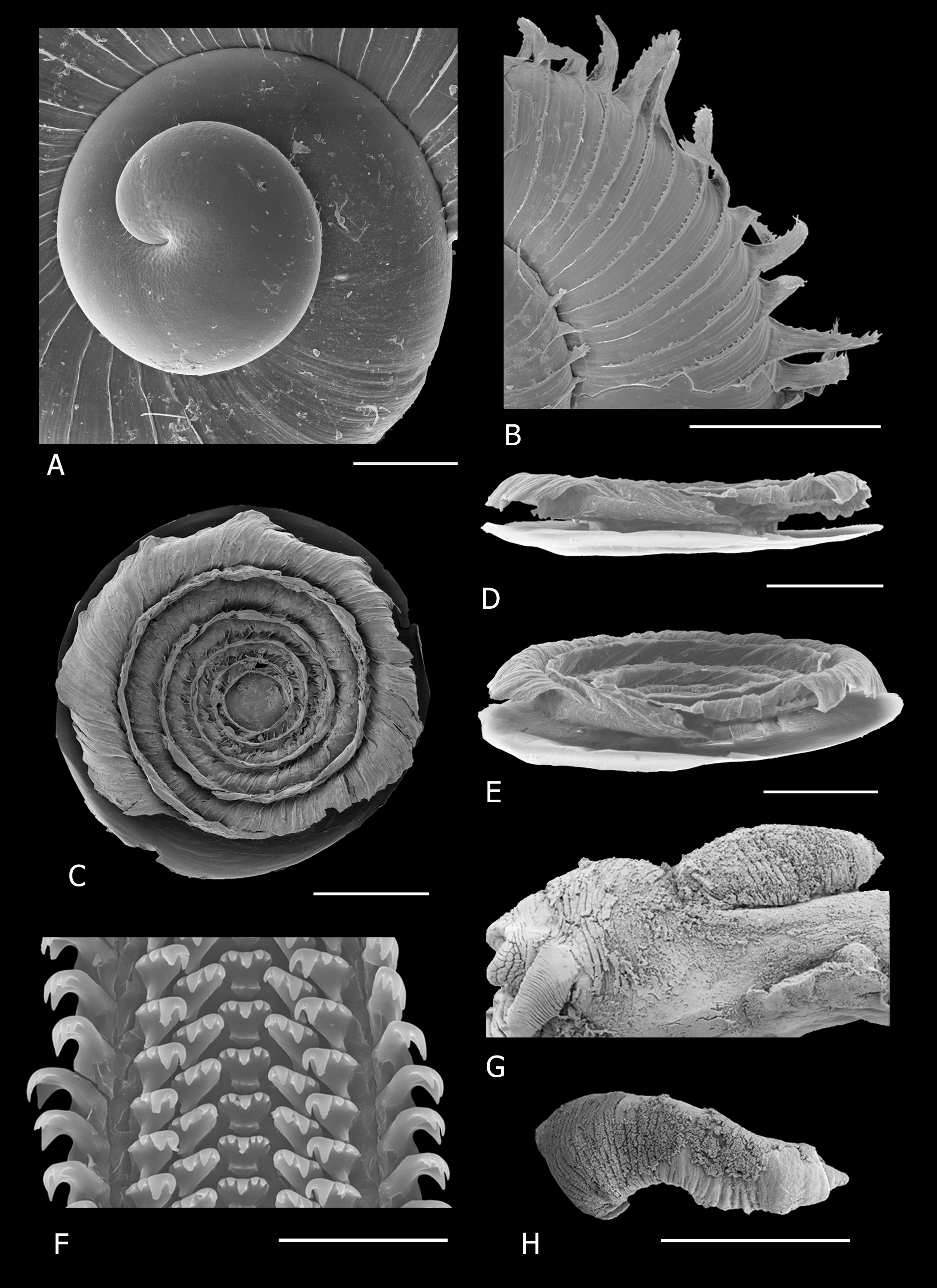
Figs 6–7 View Fig View Fig , 8 View Fig A–B, 9
Cyclotus alabastris Craven, 1880: 619 (type loc.: Cape Recif, Algoa Bay [Craven]).
Cyclophorus (Maizania) alabastris – Kobelt 1902: 149 .
Chondrocyclus alabastris – Connolly 1929: 238 View in CoL ; 1939: 539.
Diagnosis
Shell small, very depressed, lenticular; protoconch mammillate and tilted; periostracum with axial costae developing at the periphery elongated triangular flanges usually with serrated edges; operculum flattened, exterior portion shallowly concave, with step-shaped multispiral lamella terminating in solid fringe reflexed over peristome; radula with two large cusps on second lateral tooth.
Etymology
From ‘alabaster’, an almost transparent white stone. In his description Craven (1880) describes the species as “semitransparent, of a pure white colour”.
Type material examined
Syntypes
SOUTH AFRICA – Eastern Cape • 7 specimens; syntypes of Cyclotus alabastris Craven, 1880 ; Cape Colony, Algoa Bay , Cape Recif; A.E. Craven leg.; on Sand-Hills; 27 Feb. 1875; NHMUK 1891.3.7.42- 47. ( Fig. 6A View Fig )
Other material examined
SOUTH AFRICA – Eastern Cape • 8 specimens; Port Elizabeth, The Island Nature Reserve, indigenous Southern Coastal forest in south facing valley; 33.9867°S, 25.3715°E; 18 Sep. 2008; M. Cole leg.; ELM D15931 GoogleMaps • 36 specimens; same collection data as for preceding; 27 May 2011; M. Cole leg.; ELM D16885 GoogleMaps • 7 specimens; same collection data as for preceding; ELM W03640 GoogleMaps • 3 specimens; same collection data as for preceding; NHMUK 20120270 View Materials GoogleMaps • 2 specimens; same collection data as for preceding; NMW.Z.2012.065.00003 GoogleMaps • 1 specimen; Port Elizabeth, Settlers Park , indigenous riverine forest; 33.9703° S, 25.6123°E; 16 Mar. 2005; A. Moussalli and D. Stuart-Fox leg.; in leaf-litter; NMSA W4602 View Materials GoogleMaps • 5 specimens; Van Stadens River gorge, west of Port Elizabeth , tall forest on steep slope with stream running down to river; 33.9120°S, 25.2051°E; 22 Sep. 2008; M. Cole leg.; ELM D15969 GoogleMaps • 16 specimens; same collection data as for preceding; 27 Sep. 2011; M. Cole leg.; ELM D16882 GoogleMaps • 2 specimens; same collection data as for preceding; ELM W03638 GoogleMaps • 3 specimens; Loerie Restcamp, near PPC quarry; 33.7971°S, 24.9654°E; 22 Sep. 2008; M. Cole leg.; ELM D15924 GoogleMaps • 24 specimens; Maitland Nature Reserve , 2 km from mouth on east side of river, forest on steep slope; 33.9774°S, 25.3121°E; 26 Sep. 2011; M. Cole, D. Herbert and L. Davis leg.; ELM D16881 GoogleMaps • 2 specimens; Ningi, (formerly Yellowwoods Farm), on west side of Maitland River 4.5 km upstream of mouth, riverine forest with large Yellowwoods ; 33.9304° S; 25.2083° E; 27 Sep. 2011; M. Cole, D. Herbert and L. Davis leg.; ELM D16883 GoogleMaps • 13 specimens; Ferndale, Patensie, Ratelkloof , valley of Noaga River ; 33.7164°S, 24.8503°E; 28 Sep. 2011; M. Cole, D. Herbert and L. Davis leg.; ELM D16884 GoogleMaps • 5 specimens; same collection data as for preceding; ELM W03639 GoogleMaps • 53 specimens; Gamtoos River mouth, dune forest east of mouth; 33.9574° S, 25.0477°E; 40 m a.s.l.; 28 Sep. 2011; M. Cole, D. Herbert and L. Davis leg.; ELM D16886 GoogleMaps • 8 specimens; same collection data as for preceding; ELM W03641 GoogleMaps • 1 specimen; Kap River , north bank, indigenous riverine forest on shady, south-facing slope; 33.4830°S, 27.0807° E; 30 m a.s.l.; 13 May 2011; M. Cole leg.; ELM D16887 GoogleMaps • 1 specimen; same collection data as for preceding; 30 Dec. 2002; M. Cole leg.; ELM W03026 GoogleMaps • 34 specimens; Olifantskop, Southern Mistbelt forest ; 33.3173° S, 26.4991°E; 9 Sep. 2011; M. Cole, D. Herbert and L. Davis leg.; ELM D16890 GoogleMaps • 8 specimens; same collection data as for preceding; ELM W03643 GoogleMaps • 4 specimens; Van Stadens Pass , bottom of pass, west side of river, steep south facing slope; 33.9095°S, 25.1905°E; 16 Nov. 2012; M. and K. Cole, D. Herbert and L. Davis leg.; ELM D17016 GoogleMaps • 4 specimens; Van Stadens Pass , near top of pass, steep north-facing slope; 33.9131° S, 25.2047° E; 163 m a.s.l.; 16 Nov. 2012; M. Cole leg.; ELM D17222 GoogleMaps • 9 specimens; Berg River crossing, east bank, 9 km E of Loerie, 7.5 km N.W. of Van Stadens bridge; 33.8746°S, 25.1195°E; 17 Nov. 2012; M. and K. Cole, D. Herbert and L. Davis leg.; ELM D17026 GoogleMaps • 6 specimens; same collection data as for preceding; ELM W03668 GoogleMaps • 48 specimens; Stinkhoutkloof, 11 km N. E of Loerie, 15 km N.W. of Van Stadens ; 33.7993°S, 25.0967°E; 17 Nov. 2012; M. and K. Cole, D. Herbert, L. Davis and Edwards family leg.; ELM D17034 GoogleMaps • 6 specimens; Addo National Park, Zuurberg section, forest in valley of river, on 4 hour trail; 33.3403°S, 25.7362°E; 477 m a.s.l.; 19 Nov. 2012; M. and K. Cole leg.; ELM D17045 GoogleMaps • 1 specimen; same collection data as for preceding; ELM W03676 GoogleMaps • 7 specimens; Port Elizabeth, Lovemore Heights, south facing slope, Southern Coastal forest ; 33.9928°S, 25.5121°E; 278 m a.s.l.; 18 Nov. 2012; M. and K. Cole leg.; ELM D17120 GoogleMaps • 1 specimen; same collection data as for preceding; ELM W03733 GoogleMaps • 31 specimens; Grahamstown, Mountain Drive , south facing slope; 33.3281° S, 26.5006°E; 10 Mar. 2007; M. Bursey and V. Ndibo leg.; in leaf-litter; ELM D15286 GoogleMaps • 36 specimens; same collection data as for preceding; 20 Nov. 2009; M. Cole leg.; ELM D16888 GoogleMaps • 18 specimens; same collection data as for preceding; ELM W03642 GoogleMaps • 3 specimens; same collection data as for preceding; NHMUK 20120269 View Materials GoogleMaps • 38 specimens; same collection data as for preceding; 33.3292° S, 26.4991° E; 6 Feb. 2011; R. Daniels leg.; ELM D16889 GoogleMaps • 1 specimen; same collection data as for preceding; ELM W3690 View Materials GoogleMaps • 2 specimens; same collection data as for preceding; NMW.Z.2012.065.00002 GoogleMaps • 13 specimens; Grahamstown, Belmont Valley ; 33.3153°S, 26.5861° E; 1978; D. Herbert leg.; NMSA W581 View Materials GoogleMaps • 7 specimens; Paradise Kloof, 8 km SW of Grahamstown, runs down southwards into upper Howison’s Poort ( Palmiet River ) from the Coldspring Ridge ; 33.3444° S, 26.4466° E; 710 m a.s.l.; 28 Feb. 2013; M. Cole leg.; collected at top of kloof; ELM D17220 GoogleMaps • 9 specimens; same collection data as for preceding; ELM W03740 GoogleMaps • 5 specimens; Coleridge, near Stones Hill, 8 km SE of Grahamstown, south facing slope, Southern Mistbelt Forest ; 33.3334° S, 26.6156° E; 2 Mar. 2013; M. and S. Cole leg.; ELM D17221 GoogleMaps • 2 specimens; same collection data as for preceding; ELM W03741 GoogleMaps .
Description
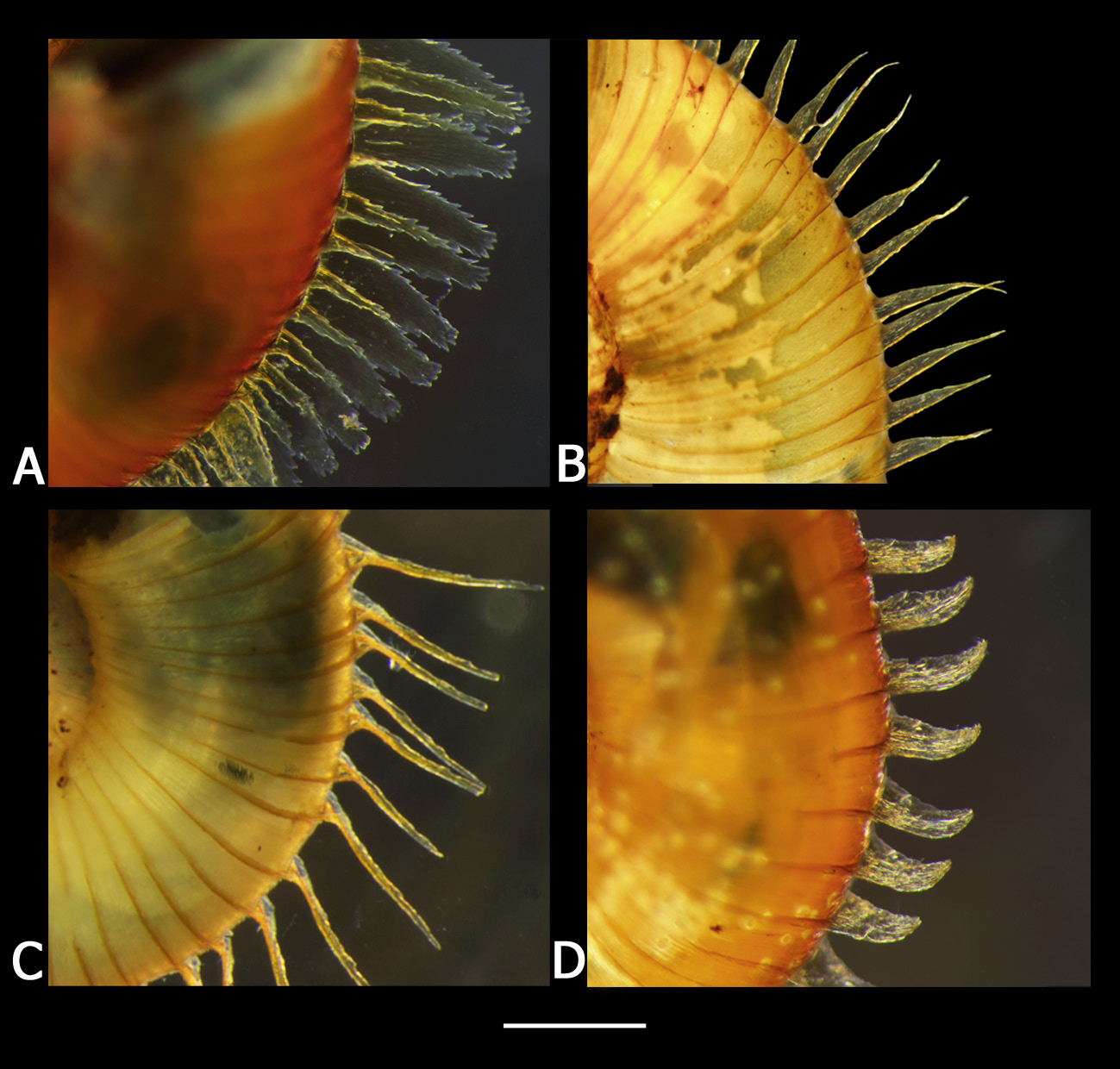
SHELL ( Fig. 6 View Fig B–D). Small, usually very depressed, lenticular, adult diameter 3.7–5.32 mm, height 1.92–2.86 mm, diameter:height 1.79–2.28 (n = 20) (from The Island Nature Reserve, Port Elizabeth, close to type locality). Variation in dimensions between populations is given in Table 1 View Table 1 . Spire little exserted, protoconch acutely mammillate and tilted. Embryonic shell ( Fig. 7A View Fig ) approx. 2.25 whorls, microscopically malleate, sculpture strongest on earliest part, junction between embryonic shell and teleoconch evident with development of costae on teleoconch. Teleoconch comprising 2.5 whorls, convex, rapidly increasing, suture deeply impressed. Aperture circular, last whorl descending near aperture, peristome simple, continuous and free. Umbilicus wide and deep, exposing all the whorls. Periostracum glossy, honey-brown and lacquer-like with lamellate axial costae at regular intervals, 67– 97 on last whorl (average 80; n = 47), their edges scalloped or serrated in the majority of populations ( Fig. 8A View Fig ) and expanded into elongated flanges at periphery, flanges smooth with a spine-tip in populations from around Grahamstown ( Fig. 8B View Fig ); intervals between costae with 3–6 microscopic axial threads. Shell translucent honey brown when fresh.
LIVING ANIMAL. Dark grey.
OPERCULUM ( Fig. 7 View Fig C–E). Duplex outer portion shallowly concave, and consisting of a multispiral lamella with five whorls, at its growing edge the top edge of the lamellar blade is sloping, becoming perpendicular to the disc where it is attached; fringe of fused bristles emanates near top of vertical portion of lamellar blade on its outer surface and curves upwards and outwards forming a shallow furrow between fringe and lamellar blade, a second very short fringe emanates from lower down on the lamellar blade; top edge of lamella does not project above level of fringe; fringe of each whorl fused to lamella of following whorl. Fringe overlaps disc slightly, but operculum can be withdrawn into aperture.
RADULA ( Fig. 7F View Fig ). Rachidian with five cusps, central approx. twice as long as two on either side of it; first lateral tooth with four cusps and sometimes a vestigial fifth, first three cusps (from centre) gradually increasing in size and fourth considerably smaller; second lateral tooth with two large cusps and two small cusps towards outside.
PENIS ( Fig. 7 View Fig G–H). Shaft more or less straight-sided and slightly flattened, with numerous annular rugae, intromittent organ short.
Distribution and habitat
Endemic to the Eastern Cape, centered around Port Elizabeth and including the Albany district ( Fig. 9 View Fig ). Found in a wider variety of vegetation types than other Chondrocyclus species: Algoa Dune Strandveld, Albany Coastal Forest, Southern Mistbelt Forest, Great Fish Thicket ( von Maltitz et al. 2003; Hoare et al. 2006; Mucina et al. 2006); in leaf-litter.
Remarks
There is variation in size of shells between populations ( Table 1 View Table 1 ), an observation also recorded by Connolly (1939). Shells in some populations are among the largest recorded in the genus (the only other species attaining a similar size is C. amathole sp. nov.). However, the types ( Fig. 6A View Fig ) from Cape Receife, populations at The Island Nature Reserve (40 km west of type locality) and at Gamtoos River mouth are smaller on average and the population at Gamtoos mouth has a distinctly less depressed shape than is typical for the species. Its diameter/height proportions resemble those of relatively less depressed species, e.g., C. convexiusculus , C. herberti sp. nov. and A. exsertus gen. et comb. nov.
There was a relatively large intraspecific divergence in C. alabastris ( Cole et al. 2019) and the species contained several very well-supported subclades ( Fig. 1 View Fig ). There was a distinct lineage in the mistbelt forest patches on the Rietberg ridge south of Grahamstown (Paradise Kloof and Coleridge in Fig. 1 View Fig ). This lineage exhibited a conspicuous variation from other populations of C. alabastris : the peripheral extensions of the axial lamellae were not serrated along the edges and each flange tapered gradually into a short spine tip ( Fig. 8B View Fig ). Specimens from these localities superficially resembled C. convexiusculus ( Fig. 8C View Fig ). However, the spines are longer in C. convexiusculus , emanating from a relatively short, broad triangular proximal portion while in C. alabastris the triangular flanges taper gradually into the short spine tip ( Fig. 8B View Fig ).
The lamellar blade of the outer portion of the operculum of C. alabastris is relatively lower and hence the operculum is less concave than that of C. convexiusculus , and has a very short fringe below the long fringe, absent in C. convexiusculus .


No known copyright restrictions apply. See Agosti, D., Egloff, W., 2009. Taxonomic information exchange and copyright: the Plazi approach. BMC Research Notes 2009, 2:53 for further explanation.
|
Kingdom |
|
|
Phylum |
|
|
Class |
|
|
Order |
|
|
Family |
|
|
Genus |
Chondrocyclus alabastris ( Craven, 1880 )
| Cole, Mary L. 2019 |
Chondrocyclus alabastris –
| Connolly M. 1939: 539 |
| Connolly M. 1929: 238 |
Cyclophorus (Maizania) alabastris –
| Kobelt W. 1902: 149 |
Cyclotus alabastris
| Craven A. E. 1880: 619 |