
Cochlostoma (Clessiniella) tergestinum ( Westerlund, 1878 )
|
publication ID |
https://doi.org/ 10.5852/ejt.2021.762.1453 |
|
publication LSID |
lsid:zoobank.org:pub:D1093CEB-7EBB-44A0-8078-8DC616B857F5 |
|
DOI |
https://doi.org/10.5281/zenodo.5188573 |
|
persistent identifier |
https://treatment.plazi.org/id/038B8791-316C-FFFD-7BF8-116BF3D126E0 |
|
treatment provided by |
Felipe |
|
scientific name |
Cochlostoma (Clessiniella) tergestinum ( Westerlund, 1878 ) |
| status |
|
Cochlostoma (Clessiniella) tergestinum ( Westerlund, 1878) View in CoL
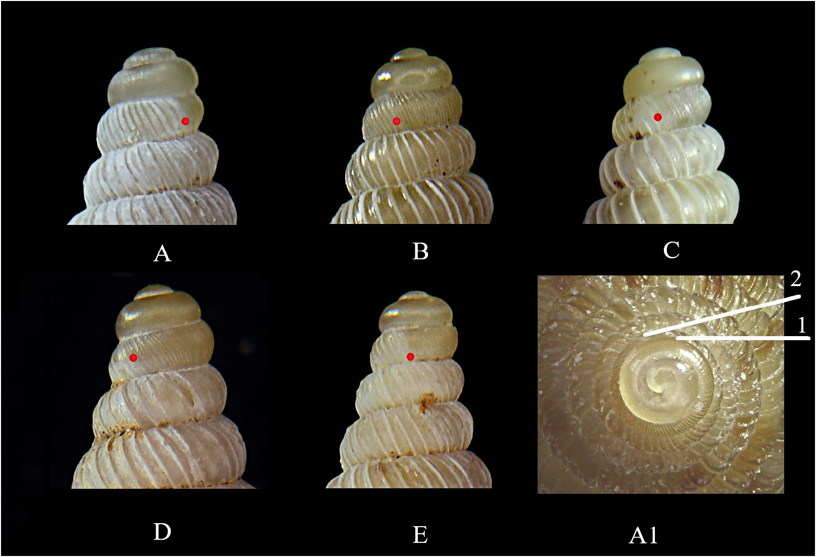
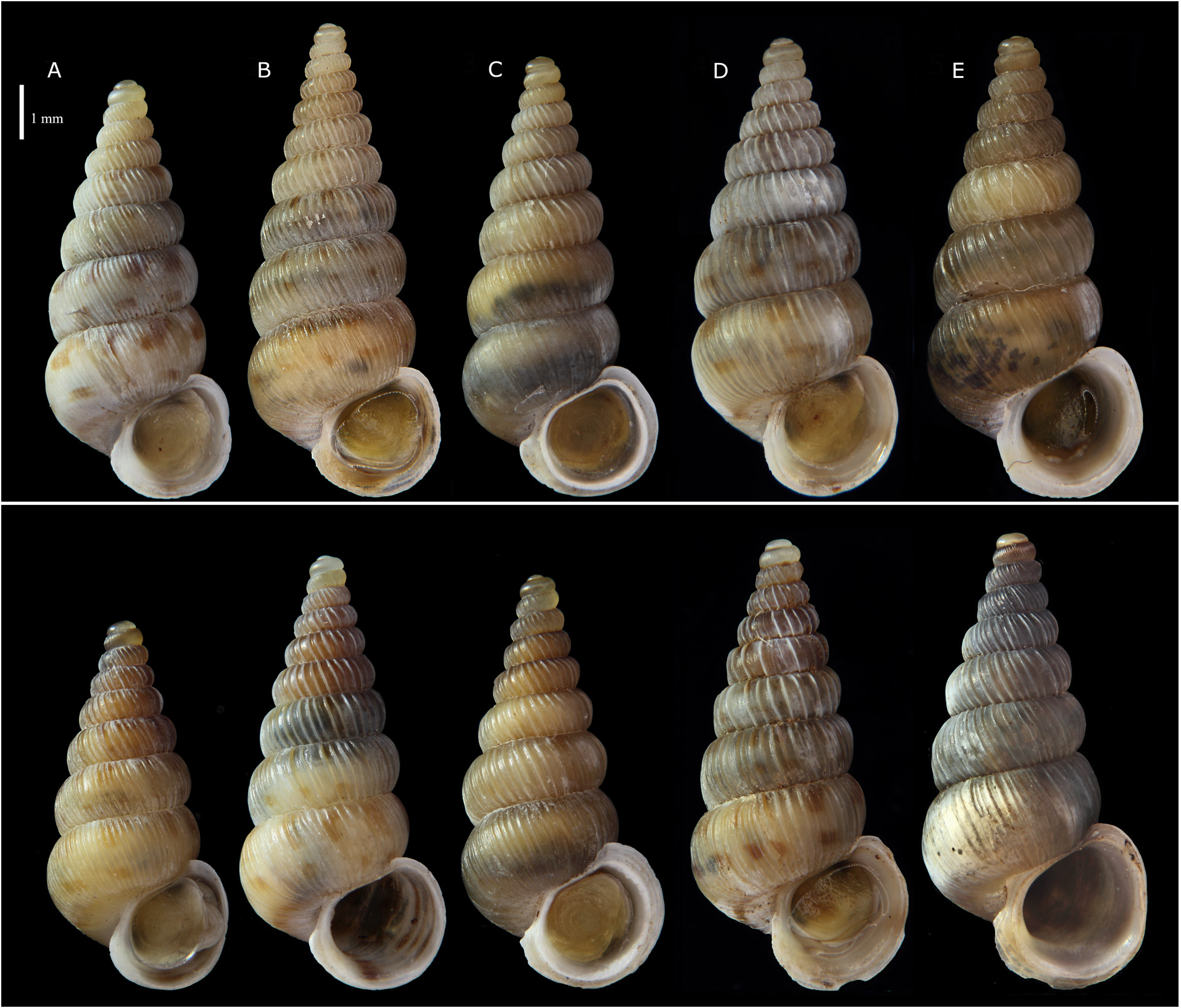
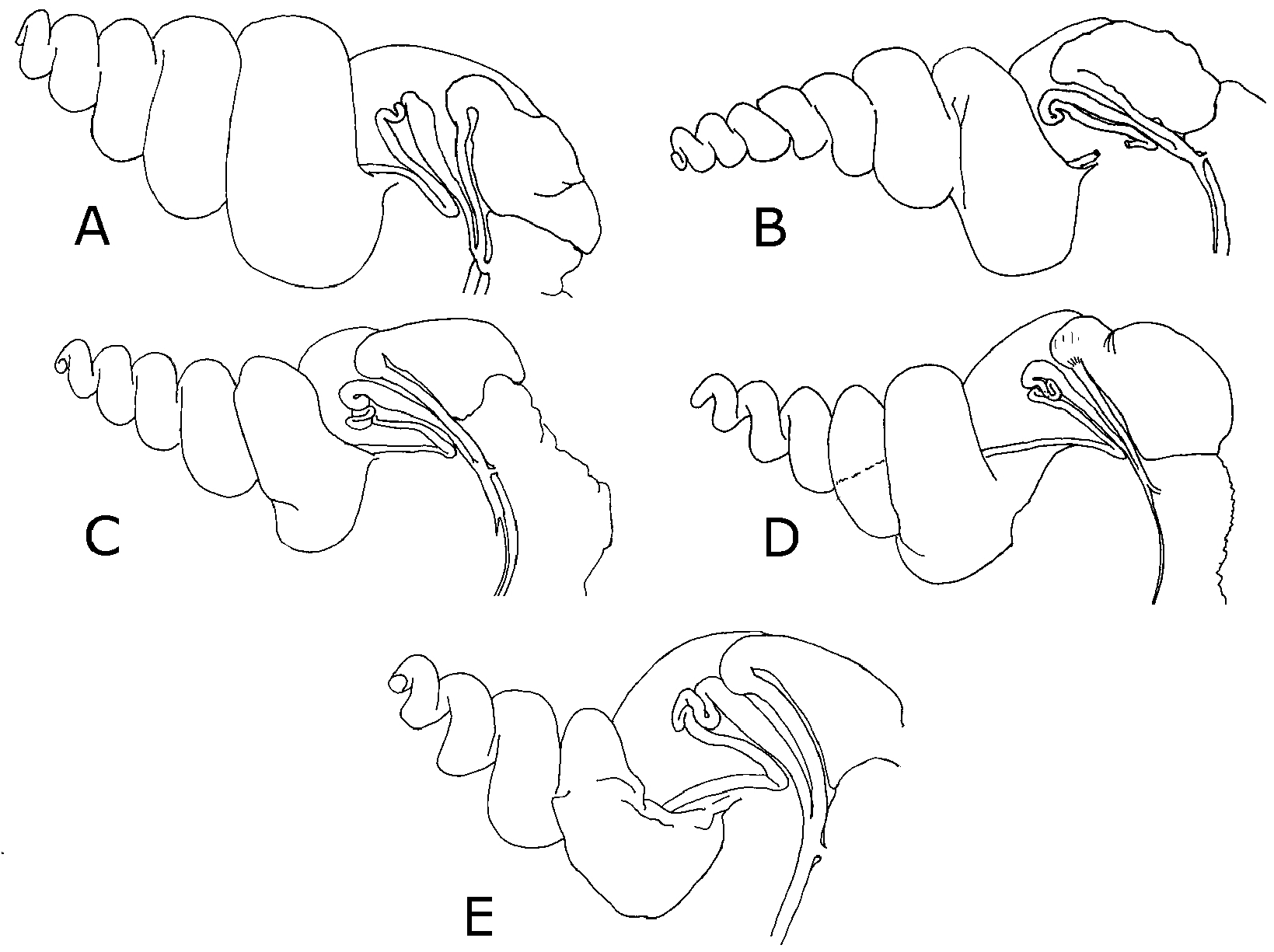
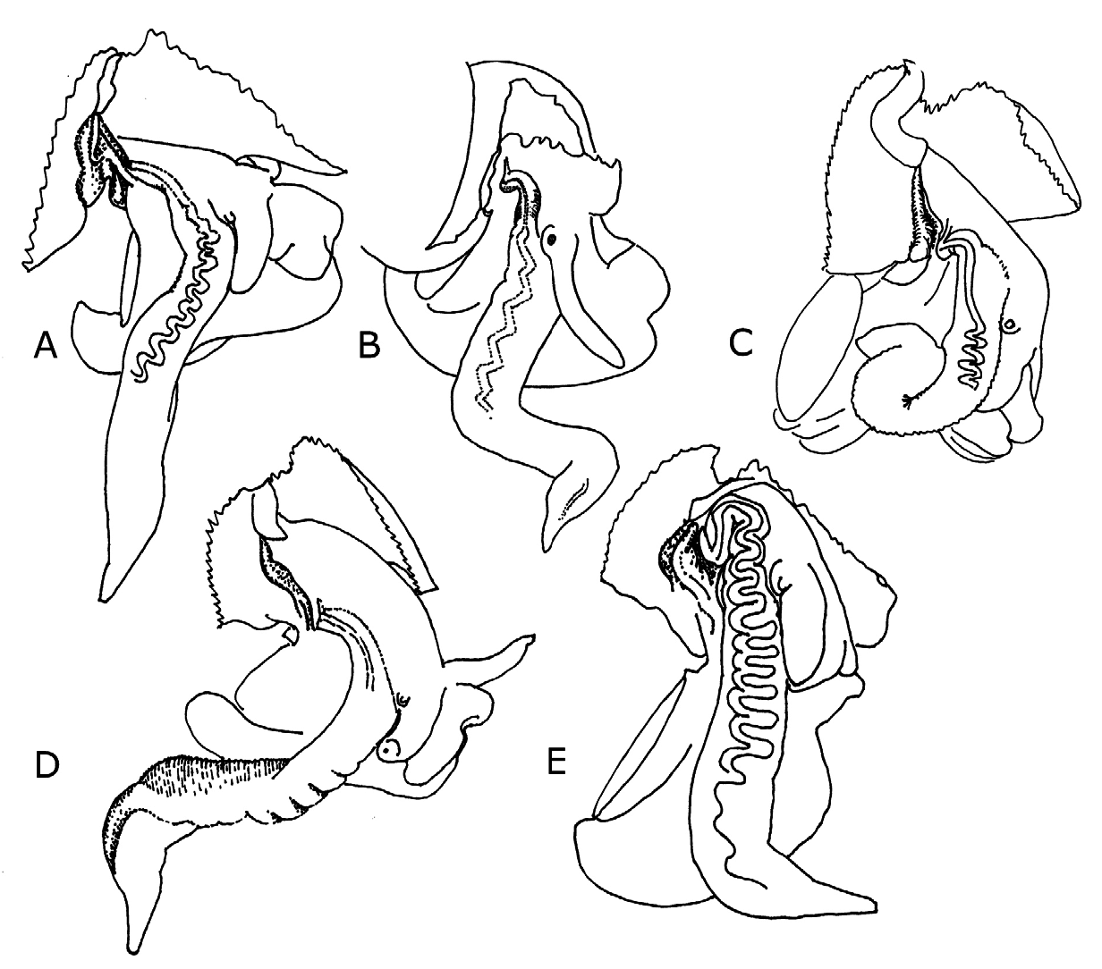
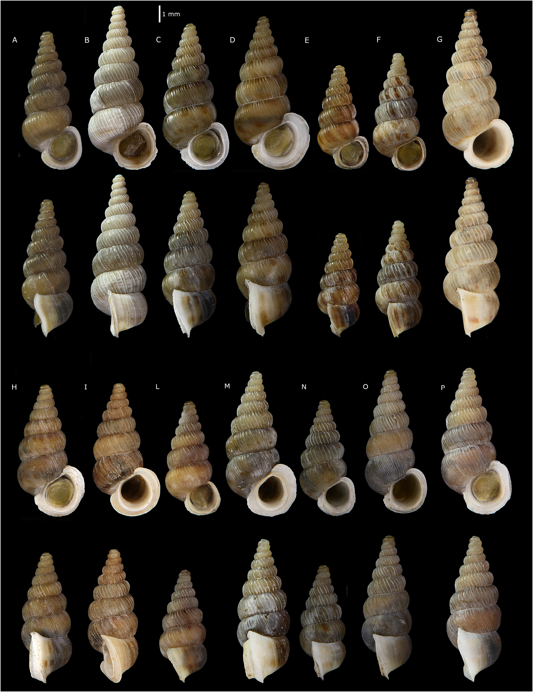
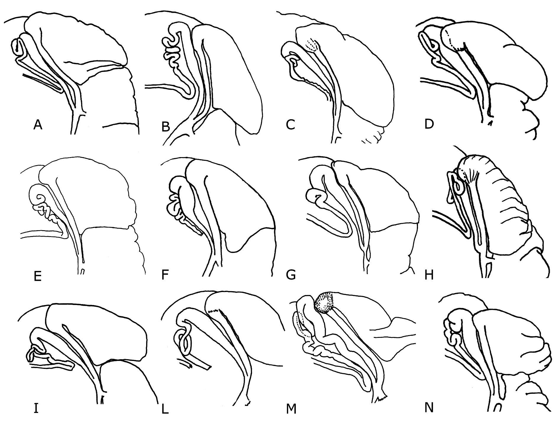
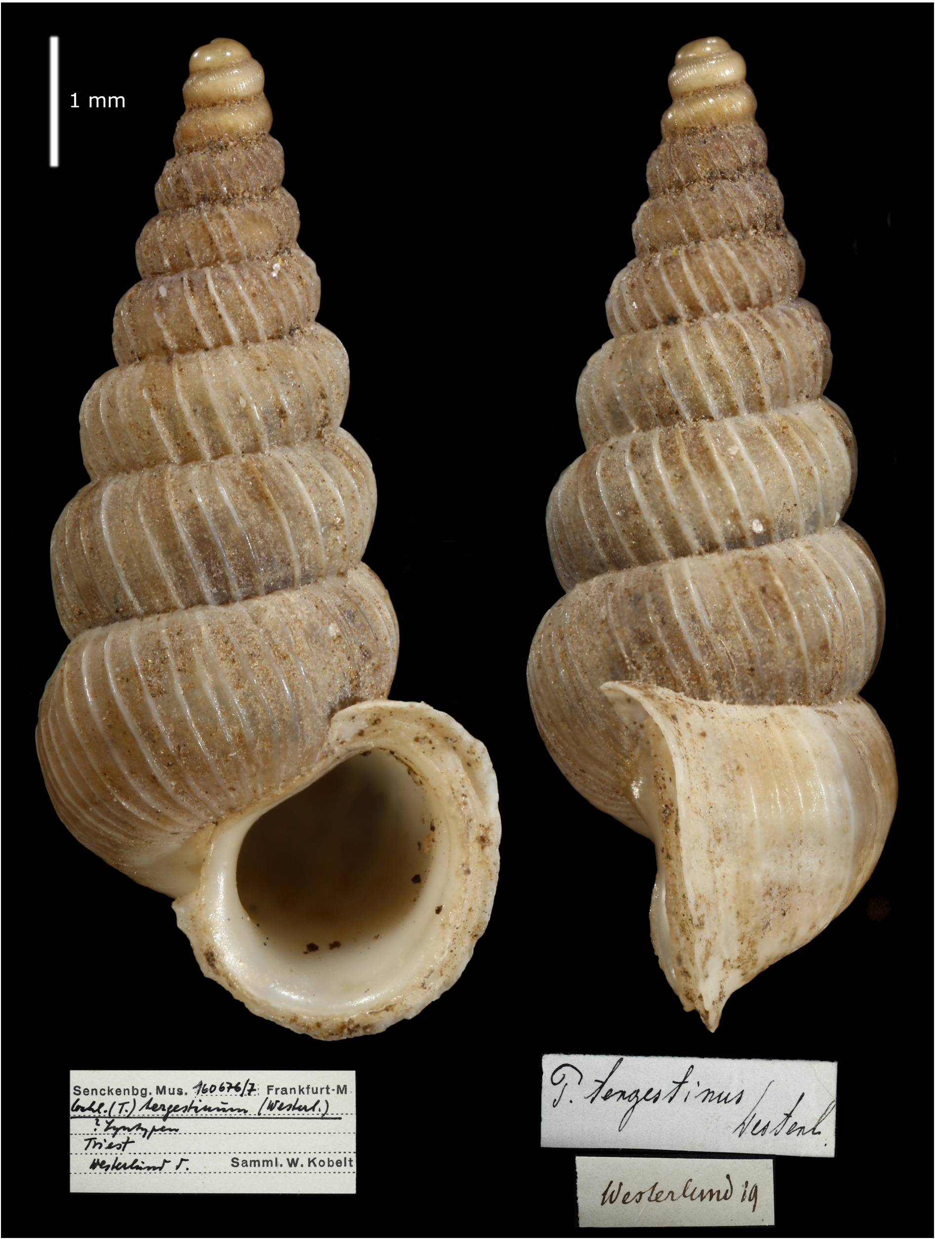
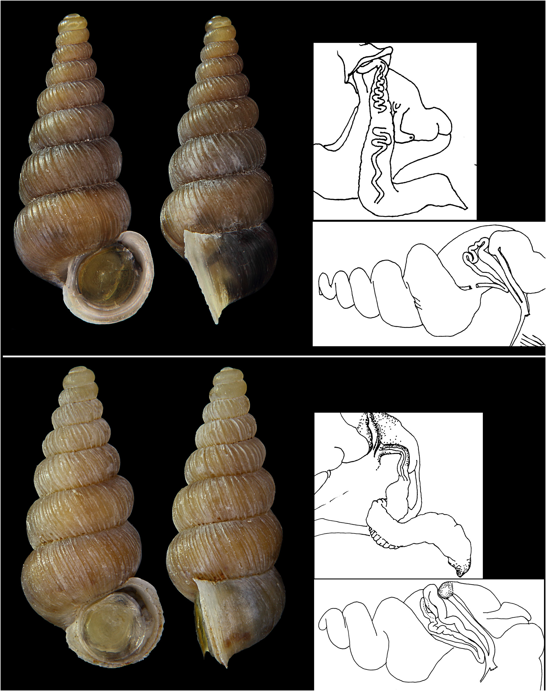
Figs 1 View Fig , 3B View Fig , 5 View Fig , 14C View Fig , 15C View Fig , 16C View Fig , 28–30 View Fig View Fig View Fig , 34 View Fig (bottom), 35 (bottom), 36 (top)
Pomatias tergestinus Westerlund, 1878: 108–109 (“Triest”).
Pomatias tortivus Westerlund, 1885: 124 (“Fiume, San Daniel u. Karstgebirge”, which should be Rijeka in Croatia and Štanjel in Slovenia).
Pomatias tergestinus var. grahovana A.J. Wagner, 1897: 616 , pl. 9 fig. 89 (“Grahovo bei Fiume”, a locality ca 10 km north of Rijeka in Croatia).
Pomatias tergestinus var. tortiva – A.J. Wagner 1897: 616, pl. 9 fig. 88.
Cochlostoma tergestinum View in CoL − Welter-Schultes 2012: 102.
Diagnosis
Shell very variable, lip curved backwards more or less abruptly at the columellar side. Strong ribs on the teleoconch, in most of the populations widely spaced and, on the upper whorls, whitish and contrasting with the corneous, dark brown to light yellow, shell background. Visceral oviduct with convoluted loops path; body spermiduct straight.
Type material
Syntypes ITALY • “Triest” [ Friuli Venezia Giulia, Trieste ]; Westerlund leg.; SMF160677/1 • same label data as for preceding; SMF 160676/7 ( Fig. 30 View Fig ) .
Other material
AUSTRIA • Dobratsch ; 46.59222° N, 13.6825° E; 2009; Mildner and Giovannelli leg.; EZ0799 GoogleMaps • Kranzwand ; 46.588799° N, 13.75002° E; Jul. 2015; AL leg.; NHMW109000 View Materials GoogleMaps .
CROATIA • Sveta Nedelja near Labin; 45.13741° N, 14.14488° E; 2000; De Mattia leg.; WdM6961 GoogleMaps • Brest , Cicaria; 45.45444° N, 14.00625° E; Apr. 2008; De Mattia leg.; WdM6715 GoogleMaps • Drivenik spring; 45.24147° N, 14.64828° E; Mar. 2009; De Mattia leg.; WdM6714 GoogleMaps • from A6 to 501 down Bakar; 45.30543° N, 14.58579° E; Jul. 2009; De Mattia and Zallot leg.; EZ0938 GoogleMaps • Jakačici ; 45.179494° N, 14.004384° E; 2009; De Mattia leg.; WdM6699 GoogleMaps • Kremenje-Buje ; 45.43558° N, 13.68499° E; Jan. 2008; De Mattia leg.; WdM6400 GoogleMaps • Kukurini ; 45.19369° N, 14.07216° E; Feb. 2009; De Mattia leg.; WdM6698 GoogleMaps • Limski Kanal ; 45.12957° N, 13.74039° E; 2010; De Mattia leg.; WdM6693 GoogleMaps • Limski Kanal ; 45.12957° N, 13.74039° E; Jun. 2010; De Mattia leg.; WdM6998 GoogleMaps • Mala Ucka ; 45.27605° N, 14.19715° E; 2009; De Mattia leg.; WdM6768 GoogleMaps • Meja , Bakarac; 45.3037° N, 14.58348° E; 2009; De Mattia leg.; WdM6951 GoogleMaps • Momjan ; 45.442° N, 13.71384° E; 2009; De Mattia leg.; WdM6854 GoogleMaps • Mt Učka , beech forest ; 45.30636° N, 14.20865° E; 2009; De Mattia leg.; WdM6794 GoogleMaps • Mt Učka , top; 45.28967° N, 14.20341° E; 2009; De Mattia leg.; WdM6794 GoogleMaps • Pazin ; 45.24134° N, 13.93099° E; Jun. 1986; Drimmer leg.; HNHM97227 GoogleMaps • Permani ; 45.43742° N, 14.28905° E; 2009; De Mattia leg.; WdM6708 GoogleMaps • Raša ; 45.0872° N, 14.08854° E; 2010; De Mattia leg.; WdM6968 GoogleMaps • Rasko Polje ; 45.15638° N, 14.0538° E; 2010; De Mattia leg. GoogleMaps • EZ0813 • Rasko Polje ; 45.15638° N, 14.0538° E; 1900; De Mattia leg.; EZ1027 GoogleMaps • Zminj ; 45.13991° N, 13.88873° E; 2000; De Mattia leg.; WdM6700 GoogleMaps .
ITALY • Val Rosandra ; 45.62° N, 13.87139° E; 2000; Zallot leg.; EZ0840 GoogleMaps • Torri di Monrupino ; 45.71878° N, 13.80594° E; 1998; Zallot leg.; EZ0839 GoogleMaps .
SLOVENIA • Abram-Nanos Mt ; 45.82055° N, 14.01433° E; 2008; De Mattia leg.; WdM6731 GoogleMaps • Brestovica pri Komnu ; 45.80996° N, 13.65016° E; 2009; De Mattia leg.; WdM6948 GoogleMaps • Čepno ; 45.67071° N, 14.09732° E; Jun. 2009; De Mattia leg.; WdM6866 GoogleMaps • Črnotiče-Črni Kal ; 45.55276° N, 13.88633° E; Mar. 2009; De Mattia leg.; EZ1028 GoogleMaps • Dolina Nanos-Abran-Podkraj ; 45.79813° N, 14.06699° E; Apr. 2009; De Mattia leg.; WdM6733 GoogleMaps • Farjev Vrh ; 45.92429° N, 13.95442° E; 2009; De Mattia leg.; WdM6740 GoogleMaps • Golac, Vela Vrata ; 45.51315° N, 14.02969° E; 2009; De Mattia leg.; WdM6762 GoogleMaps • Gorjansko ; 45.78485° N, 13.70068° E; 2000; De Mattia leg.; WdM6950 GoogleMaps • Hruščica ; 45.85832° N, 14.1117° E; 2000; De Mattia leg.; WdM2409 GoogleMaps • Ilirska Bistrika ; 45.56944° N, 14.23917° E; 2009; Zallot leg.; EZ0821 GoogleMaps • Kovk ; 45.94614° N, 13.95058° E; 2015 GoogleMaps • De Mattia leg.; WdM6737 • Križna Jama ; 45.82003° N, 14.24579° E; Jun. 2009; Jochum leg.; HNHM97142 GoogleMaps • Markovščina-Dimnice cave ; 45.58357° N, 14.03994° E; 2009; De Mattia leg.; WdM6765 GoogleMaps • Mt Kobilica ; 46.06528° N, 13.80907° E; 2005; De Mattia leg.; WdM6849 GoogleMaps • Mt Nanos, top, loc. Plesa ; 45.79813° N, 14.06699° E; Jun. 2005; De Mattia leg.; WdM0000 GoogleMaps • Mt Snežnik 1161; 45.56816° N, 14.37049° E; Jun. 2010; De Mattia leg.; WdM7012 GoogleMaps • Mt Snežnik 1390; 45.57179° N, 14.41044° E; Jun. 2010; De Mattia leg.; EZ0965 GoogleMaps • Mt Snežnik 1447; 45.57877° N, 14.43839° E; Jun. 2010; De Mattia leg.; EZ0964 GoogleMaps • Mt Snežnik 1450; 45.58195° N, 14.43129° E; Jun. 2010; De Mattia leg.; EZ0962 GoogleMaps • Mt Snežnik car parking ; 45.58235° N, 14.43117° E; Jun. 2002; De Mattia leg.; WdM7006 GoogleMaps • Mt Vremščica ; 45.69898° N, 14.03388° E; 2009; De Mattia leg.; WdM6758 GoogleMaps • near Gorenje; 45.82976° N, 14.10755° E; 2009; Zallot leg.; EZ0817 GoogleMaps • near Logatec; 45.88076° N, 14.27448° E; 2009; Zallot leg.; EZ0828 GoogleMaps • Osp , 45.57071° N, 13.86168° E; 2010; De Mattia leg.; WdM6756 GoogleMaps • Ospo , small cliff ; 45.57119° N, 13.8582° E; May 2010; De Mattia leg.; WdM6993 GoogleMaps • Otlica ; 45.92822° N, 13.90918° E; 1986; De Mattia leg.; WdM6752 GoogleMaps • Planina ; 45.82405° N, 14.24708° E; 2000; Zallot leg.; EZ0823 GoogleMaps • Planina ; 45.82972° N, 14.25056° E; 2000; Zallot leg.; EZ0824 GoogleMaps • Planina , Postojna; 45.83° N, 14.26056° E; 2009; Zallot leg.; EZ0826 GoogleMaps • Podgorje ; 45.53872° N, 13.9449° E; 2000; De Mattia leg.; WdM6735 GoogleMaps • Podgorje ; 45.5364° N, 13.9463° E; 2009; De Mattia leg.; WdM6735 GoogleMaps • Podlešče-Bainsizza ; 46.05738° N, 13.72709° E; May 2009; De Mattia leg.; WdM6814 GoogleMaps • Prešnica ; 45.56587° N, 13.94191° E; Mar 2009; De Mattia leg.; WdM6734 GoogleMaps • Pri Cerkvi- Bainsizza ; 46.04133° N, 13.77584° E; 2009; De Mattia leg.; WdM6834 GoogleMaps • Rakow Skocjan; 45.79467° N, 14.28948° E; 2010; Zallot leg.; EZ0838 GoogleMaps • San Canzian (Škocjan); 45.66532° N, 13.99356° E; 2009; De Mattia leg.; WdM6754 GoogleMaps • Senožeče ; 45.71421° N, 14.07856° E; 2009; De Mattia leg.; WdM6865 GoogleMaps • 10 km S of Vrhnika; 45.88549° N, 14.26091° E; 2000; Zallot leg.; EZ0827 GoogleMaps • Vrhnika, Močilnik ; 45.95591° N, 14.29268° E; 2009; Zallot leg.; EZ0829 GoogleMaps .
Remarks
The original indication of the type locality is rather vague, since only a city in the Friuli-Venezia Giulia region, in the easternmost part of Italy is indicated. The closest to Trieste where we found the species is at “Val Rosandra”, 8 km north-east of the city. The fresh specimens collected there have shell features similar to those of the syntypes. We therefore consider them as topotypical.
Description
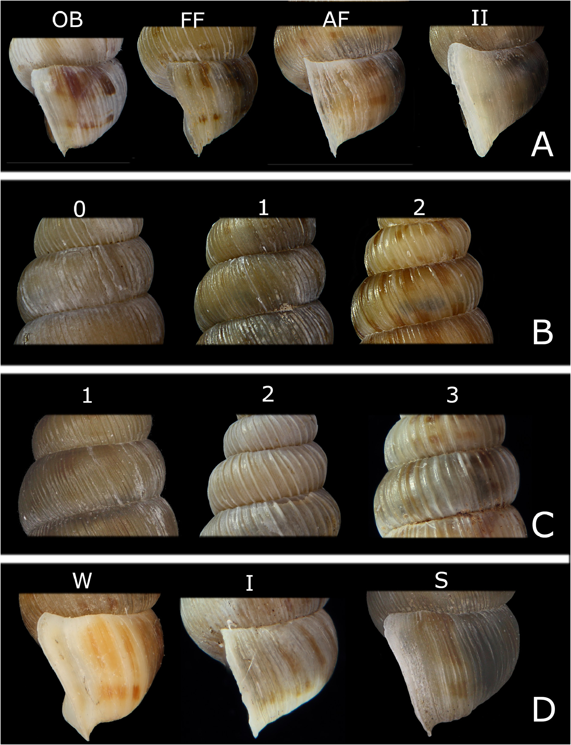
SHELL. The size of the shells is extremely variable (height 6.1–9.6 mm in the females) as well as their general morphology (see Fig. 28 View Fig ). Several populations are spotless whereas others have clear spots on the teleoconch. Depending on the population, the lip can be either poorly or even hugely developed. In lateral view, the body whorl, while approaching the aperture, may widen in various ways, depending on the population ( Fig. 4A View Fig : FF, AF, II). The H/W ratio is very variable and the slenderness of the shells in different populations varies accordingly.
FEMALE GENITALIA. There is a long, club-shaped seminal receptacle. In some cases there is a change of colour at its base, presumably indicating the starting point of the rather long distal oviduct. As shown in Table 5 View Table 5 , there is a considerable variability in the part of the seminal receptacle that is curved down and in the number of loops.
MALE GENITALIA. The inflated penis is longer than the body. The penial spermiduct is confined to the central part of the penis and gently twisted. The body spermiduct is straight and well defined.
Distribution
This species inhabits the eastern side of the province of Trieste in Italy, the southwestern part of Slovenia and the Istrian peninsula. It has also been found in several Croatian localities in the surroundings of Bakar and, quite far from its main range, on the Villacher Alps, in Austria (see Mildner 1997). The species has been erroneously reported for Albania (see Fehér & Erőss 2009).
Habitat preference
It is an obligate rock-dwelling species. Co. (Cl.) tergestinum is found in a variety of habitats, from open, exposed limestone cliffs to shady spots in deciduous and evergreen forests.
Remarks
According to Zilch (1958) and Alzona (1971) there are 3 subspecies of Co. (Cl.) tergestinum , viz. the nominate subspecies Co. (Clessiniella) tergestinum tergestinum ( Westerlund, 1878) , Co. (Clessiniella) tergestinum grahovanum (A.J. Wagner, 1897) and Co. (Clessiniella) tergestinum tortivum ( Westerlund, 1885) .
For the time being, we here synonymize these nominal taxa because the conchological features which supposedly characterize them, like measures, density and prominence of the ribs, and the structure of the lip, are population features without an obvious geographical pattern. There is no significant correlation between latitude and longitude of the locality of the sample and the character states that are mentioned in the original description of the so-called subspecies. Moreover, in the surroundings of Trieste, the type locality of the nominate subspecies, only populations with some ‘ tortivum ’ shell features, like the thin lip, can be found ( De Mattia & Prodan 2006).
Some of the populations have a peculiar shell morphology (see for instance Fig. 28E–F View Fig ); their taxonomical status should be investigated more thoroughly especially since the available molecular H3 analysis indicates that population “EZ0813” from Rasko Polje, corresponding to the specimen in Fig. 28E View Fig , stands apart from the others.


No known copyright restrictions apply. See Agosti, D., Egloff, W., 2009. Taxonomic information exchange and copyright: the Plazi approach. BMC Research Notes 2009, 2:53 for further explanation.
|
Kingdom |
|
|
Phylum |
|
|
Class |
|
|
Order |
|
|
Family |
|
|
Genus |
Cochlostoma (Clessiniella) tergestinum ( Westerlund, 1878 )
| Zallot, Enrico, Mattia, Willy De, Fehér, Zoltán & Gittenberger, Edmund 2021 |
Cochlostoma tergestinum
| Welter-Schultes F. W. 2012: 102 |
Pomatias tergestinus var. grahovana A.J. Wagner, 1897: 616
| Wagner A. J. 1897: 616 |
Pomatias tergestinus var. tortiva
| Wagner A. J. 1897: 616 |
Pomatias tortivus
| Westerlund C. A. 1885: 124 |
Pomatias tergestinus
| Westerlund C. A. 1878: 109 |