
Homalium moniliforme subsp. littorale Appleq., 2018
|
publication ID |
https://doi.org/ 10.15553/c2018v731a4 |
|
DOI |
https://doi.org/10.5281/zenodo.6309026 |
|
persistent identifier |
https://treatment.plazi.org/id/03CAA927-3A13-FFB9-E407-FBCBFC332B06 |
|
treatment provided by |
Carolina |
|
scientific name |
Homalium moniliforme subsp. littorale Appleq. |
| status |
subsp. nov. |
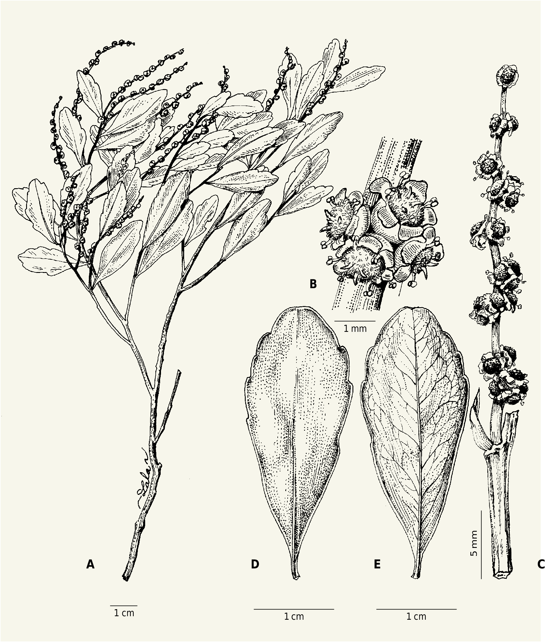
6b. Homalium moniliforme subsp. littorale Appleq. View in CoL , subspec. nova ( Fig. 3 View Fig ).
Holotypus: MADAGASCAR. Prov. Fianarantsoa: Fiv. Farafangana, firaisam-pokontany Mahabo Mananivo , fkt. Nosy ala , forêt d’A[g]nalazaha , 23°10’13’’S 47°43’27’’E, 22 m, 26.VII.2003, fl., Rabehevitra et al. 516 (MO-04810771! GoogleMaps ; iso-: G [ G00418523 ] image seen, P [ P04705768 ]!, TEF) .
Homalium moniliforme subsp. littorale Appleq. differs from H. moniliforme H. Perrier subsp. moniliforme in having young twigs moderately pubescent with minute trichomes (vs glabrous to glabrate or minutely papillate at apex), and leaves with the petiole 1-3 mm (vs 2-7(-10) mm) and the blade usually narrowly elliptical to elliptical, (1.8-)2.7-4.7(-5.6) × 0.7-1.6(-1.9) cm.
Young twigs moderately pubescent with minute hairs. Leaves: petiole 1-3 mm; blade narrowly elliptical to elliptical (oblanceolate especially when young), (1.8-)2.7-4.7(-5.6) × 0.7-1.6(-1.9) cm; margins serrulate to crenate-serrate or subentire; apex rounded-acute to rounded (slightly acuminate with rounded tip).
Vernacular names. – “Fotsiakara” (Ludovic et al. 870); “Fotsiakara mainty” (Ludovic 649); “Fotsiakara minty” (Ludovic et al. 696); “Fotsikara minty” (Ludovic 761); “Hazontsindrano” (Louvel 53). Uses. – Wood is used for construction (Ludovic et al. 696, 870).
Distribution, ecology and conservation status. – Homalium moniliforme subsp. littorale is native to littoral or low-elevation coastal forests from Toamasina to Toliara provinces; it is reported to occur on sand. Coastal forest, where not protected, is one of the most threatened habitat types in Madagascar. The habitat is in fact quite fragmented; three locations are within the protected area network (i.e., Mahabo/Agnalazaha, Mandena, and Ste. Luce) but continuing decline in habitat area and quality can be expected for the remainder. There are only seven distinct locations, three of which (from Tulear) are very close together. The EOO is estimated by GeoCAT as c. 10.5 km 2, and the AOO as 56 km 2. The preliminary assessment of conservation status suggests that a status of “Vulnerable” [VU B1ab(iii)+B2ab(iii)] would be appropriate, though one could argue for “Endangered” [EN] on the grounds that the habitat might be considered “severely fragmented.”
Paratypi. – MADAGASCAR. Prov. Fianarantsoa: Fkt. Vohimasy, forêt d’Agnalazaha , bloc Agnanto , 23°10’09’’S 47°41’51’’E, 28 m, 23.III.2004, fl., Ludovic 649 ( MO) GoogleMaps ; Fkt. Nosiala, forêt d’Agnalazaha , bloc de Betaindambo , 23°08’42’’S 47°42’18’’E, 31 m, 22.IV.2004, fl., Ludovic 761 ( MO) GoogleMaps ; Fkt. Nosiala, bloc forestier d’Ampandramadinika , 23°12’13’’S 47°42’41’’E, 21 m, 8.IV.2004, fl., Ludovic et al. 696 ( MO) GoogleMaps ; Nosiala, forêt d’Ampitavananima , 23°11’10’’S 47°43’02’’E, 30 m, 5.VIII.2004, fr., Ludovic et al. 870 ( MO) GoogleMaps ; MahaboMananivo , forêt de Mahabo , 23°10’20’’S 47°42’23’’E, 29 m, 23.IX.2002, fr., Rabenantoandro et al. 961 ( MO, P) GoogleMaps ; ibid. loco, 23°10’37’’S 47°43’E, 10 m, 25.IX.2002, fl., Rabenantoandro et al. 990 ( MO, P) GoogleMaps ; Trail E of Vohimasy Ankorabe , W edge of Ampanasanay forest , 23°10’56’’S 47°42’00’’E, 24 m, 19.VI.2004, fr., A. Randrianasolo et al. 853 ( MO, P) GoogleMaps ; Mahabo-Mananivo , Sahalava , 4 km à l’E du gite MBG, 23°11’27’’S 47°42’39’’E, 4 m, s.d., fl., Razafitsalama et al. 1004 ( G, MO, P) GoogleMaps . Prov. Toamasina: Fkt. Tanambao Ambodimanga , forêt de Menagisy 500 m du village Antanandava Martin, 16°47’S 49°43’E, 26.V.2010, fl., Lehavana & Zackarie 692 ( MO) GoogleMaps ; Tampina, s.d., fr., Louvel 53 ( P) ; Fénérive, forêt à Mahambo , 12.VIII.1961, fl., Peltier & Peltier 3419 ( P) ; Vohibola , à l’W de Tampina , 12-14.VIII.1957, fl., Service Forestier 18072 ( P) ; Mahambo , au S de Fénérive , 30.VIII.1957, fl. & fr., Service Forestier 18146 ( MO, P [3 sheets]) . Prov.Toliara: Mandena, 24°57’S 47°02’E, 10 m, 13.I.1990, fl., Dumetz 1184 ( MO, P) GoogleMaps ; forêt au NE de la rivière Antorendrika avant Belavenona , 24°52’S 47°07’E, 0-20 m, 22.III.1989, fl., Rabevohitra et al. 1781 ( MO, P) GoogleMaps ; Forest of Ste. Luce ( Manafiafy ), 2 km NW of Ambandrika village, 24°46’S 47°12’E, 0-10 m, 9.VI.1994, fl., A. Randrianasolo 343 ( MO, P) GoogleMaps .
No known copyright restrictions apply. See Agosti, D., Egloff, W., 2009. Taxonomic information exchange and copyright: the Plazi approach. BMC Research Notes 2009, 2:53 for further explanation.
|
Kingdom |
|
|
Phylum |
|
|
Class |
|
|
Order |
|
|
Family |
|
|
Genus |