
Lepanus geoffi Gunter & Weir, 2019
|
publication ID |
https://doi.org/ 10.11646/zootaxa.4695.3.1 |
|
publication LSID |
lsid:zoobank.org:pub:32E17629-F29A-47C8-ACCB-69A32C17B147 |
|
persistent identifier |
https://treatment.plazi.org/id/45E36AC3-6EC0-40AC-82A1-60B6C36B2092 |
|
taxon LSID |
lsid:zoobank.org:act:45E36AC3-6EC0-40AC-82A1-60B6C36B2092 |
|
treatment provided by |
Plazi |
|
scientific name |
Lepanus geoffi Gunter & Weir |
| status |
sp. nov. |
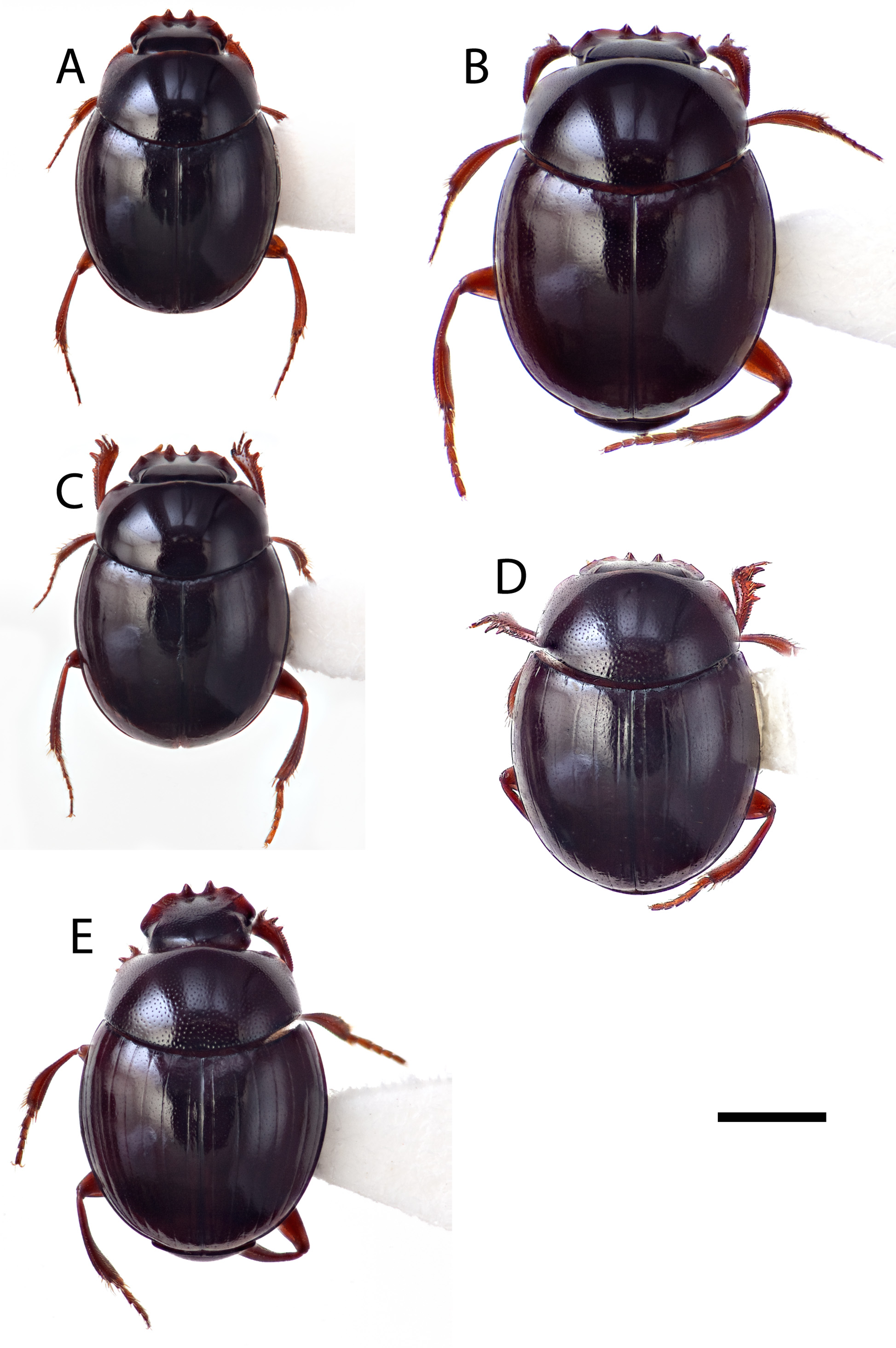
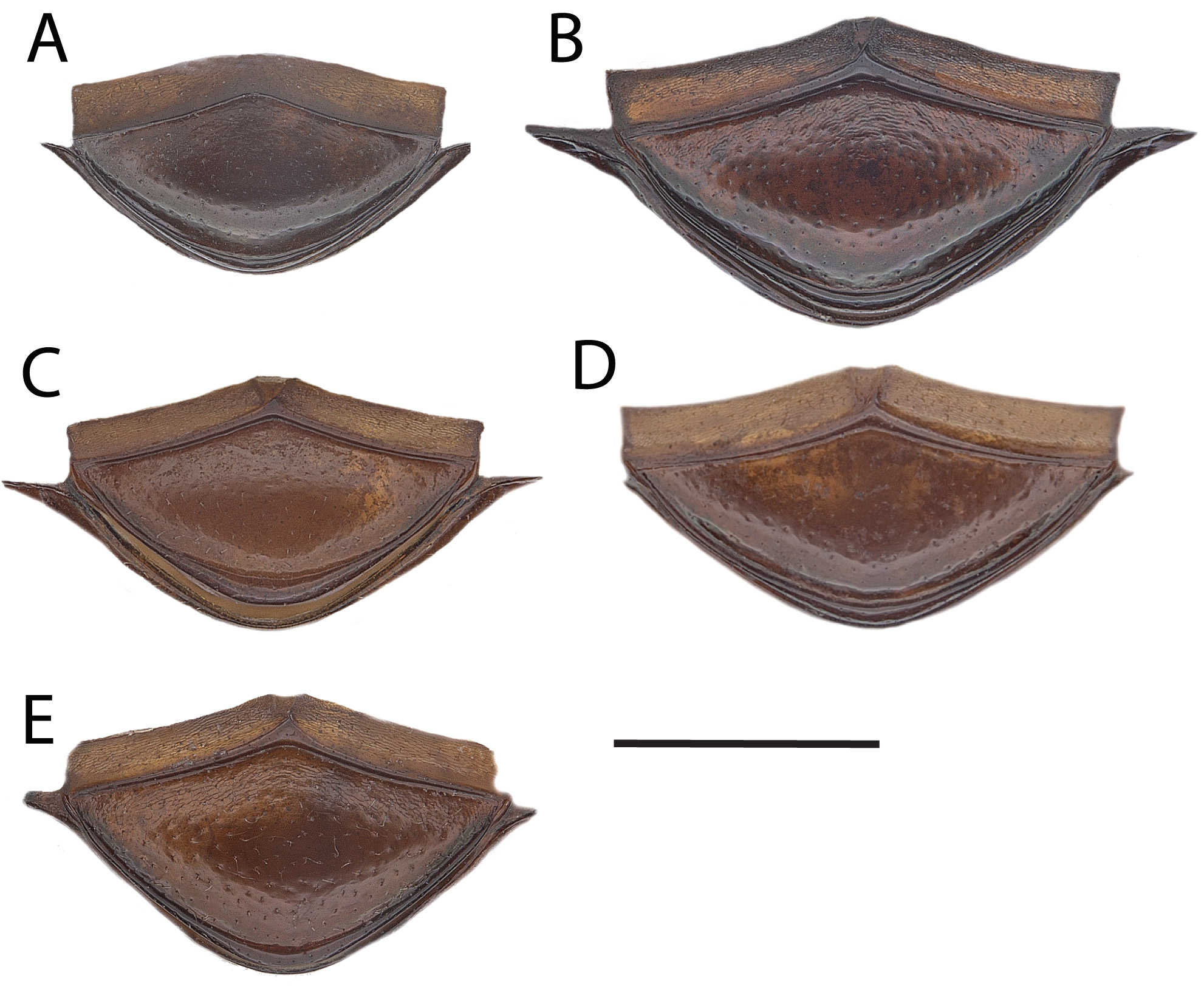
Lepanus geoffi Gunter & Weir View in CoL , new species
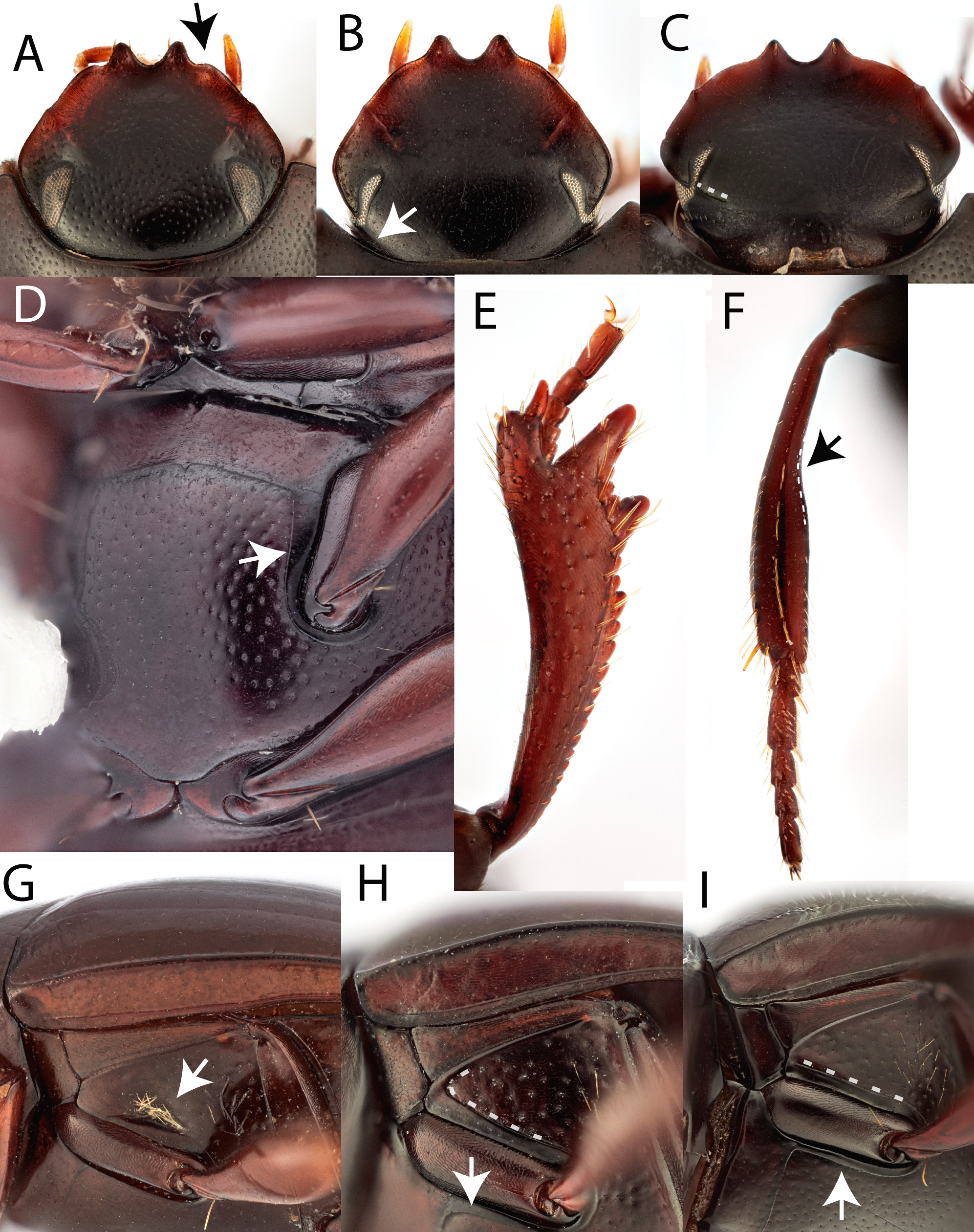
( Figs 8G View FIGURE 8 , 9A View FIGURE 9 , 10A View FIGURE 10 , 11A View FIGURE 11 )
Types series Holotype: ♂ “ 12.45S 143.14E QLD, West Claudie River , 24 Oct. 1992 T. Weir, P. Zborowski, human dung trap, closed forest” / “ ANIC Database No. 25 065538” / “ ANIC image” / “ Lepanus CYP2 det TA Weir 2012” in ANIC (12°45’0”S, 143°14’0”E) GoogleMaps . Paratypes (48 ♂, 52 ♀): West Claudie River , (12°45’0”S, 143°14’0”E), 24.x.1992 T. Weir & P. Zborowski, human dung trap, closed forest (25-023714 2 specimens ♂, 6 specimens ♀ in ANIC) GoogleMaps ; West Claudie River , 12.45°S 143.14°E, 29–30.ix.1974, G.B. Monteith (T49923–T49928 3 specimens ♂, 3 specimens ♀ in QM) GoogleMaps ; 9 km ENE Mount Tozer , [12°43’0”S, 143°17’0”E], 5–10.vii.1986, J.C. Cardale (25-059101 5 specimens ♂, 16 specimens ♀ in ANIC, 25-059101 1 specimen ♂, 1 specimen ♀ in CMNC) GoogleMaps ; 9 km ENE Mount Tozer , [12°43’0”S, 143°17’0”E], 6–10.vii.1986, T.A. Weir (25-059102 2 specimens ♂ in ANIC) GoogleMaps ; 9 km ENE Mount Tozer , [12°43’0”S, 143°17’0”E], 5–10.vii.1986, T.A. Weir (25-059096 1 specimen ♀ in ANIC) GoogleMaps ; Iron Range, Cape York Peninsula (general), [12°44’0”S, 143°17’0”E], 11–17.v.1968, G.B. Monteith (25-058478 2 specimens ♂ in QM) (paratype of L. monteithi ) GoogleMaps ; Claudie River near Iron Range , [12°45’0”S, 143°13’0”E], 19–25.vii.1978, J.F. Lawrence (25-059095 1 specimen ♂ in ANIC) GoogleMaps ; 3 km ENE Mount Tozer , [12°44’0”S, 143°14’0”E], 1–4.vii.1986, T.A. Weir (25-059098 2 specimens ♂, 3 specimens ♀ in ANIC) GoogleMaps ; 3 km ENE Mount Tozer , [12°44’0”S, 143°14’0”E], 28.vi–16.vii.1986, T.A. Weir (25-059097 1 specimen ♀ in ANIC) GoogleMaps ; 3 km ENE Mount Tozer , [12°44’0”S, 143°14’0”E], 28.vi–4.vii.1986, T.A. Weir & A. Calder (25-059099 1 specimen ♂ in ANIC) GoogleMaps ; 3 km ENE Mount Tozer , [12°44’0”S, 143°14’0”E], 28.vi–4.vii.1986, J.C. Cardale (25-059103 11 specimens ♂ 5 specimens ♀ in ANIC) GoogleMaps ; 11 km ENE Mount Tozer , [12°42’44”S, 143°18’37”E], 11–16.vii.1986, J.C. Cardale (25-059100 9 specimens ♂, 10 specimens ♀ in ANIC) GoogleMaps ; 11 km ENE Mount Tozer , [12°42’44”S, 143°18’37”E], 11–16.vii.1986, T.A. Weir (25-059104 4 specimens ♂ 1 specimen ♀ in ANIC) GoogleMaps ; East Claudie River, 12°42’50”S, 143°17’13”E, 15 m, 10–11.xii.2010, G.B. Monteith (25- 060823 1 specimen in ANIC also as COL1455 1 specimen ♂) GoogleMaps ; Gordons Creek, 12°42’47”S, 143°19’12”E, 15 m, 11–12.xii.2010, G.B. Monteith (25- 060822 3 specimens in ANIC also as COL1452 1 specimen ♂, COL1453 1 specimen ♂, COL1454 ♀) GoogleMaps ; Gordons Mine Area, Iron Range , [12°43’0”S, 143°18’0”E], 100 m, 12–18.ii.1976, G.B. Monteith (T49933 1 specimen ♀, T49934 1 specimen ♀, T49937 1 specimen ♂ in QM) GoogleMaps ; Iron Range, Cape York Peninsula , [12°45’0”S, 143°18’0”E], 50 m, 30.vi–4.vii.1977, G.B. Monteith GoogleMaps (T49914 1 specimen ♀, T49918–19 1 specimen ♂, 1 specimen ♀ in QM) .
Other material examined. 118 other specimens from 6 other locations were also examined.
Lake Boronto(=Wincheura) Newcastle Bay,Cape York [Lake Bronto,Lake Wicheura],[10°46’0”S, 142°33’0”E], 50 m, 21–25.ix.1974, G.B. Monteith (25-015629 1 specimen also as T 49922 in QM); Australian Biological Resources Study Area 2, Dividing Range 15 km W of Captain Billy Creek, Cape York Peninsula , [11°40’0”S, 142°45’0”E], 4–9.vii.1975, G.B. Monteith (25-015608 3 specimens, 25-015611 1 specimen, 25-015612 1 specimen, 25-015613 1 specimen, 25-015614 2 specimens, also as T49886–T 49896 in QM) GoogleMaps ; Australian Biological Resources Study Area 2, Dividing Range 15 km W of Captain Billy Creek, Cape York Peninsula , [11°40’0”S, 142°45’0”E], 5.ii.1976 – 12.ii.1976, G.B. Monteith (25-015615 1 specimen, 25-015616 1 specimen also as T49897–T 49898 in QM) GoogleMaps ; Australian Biological Resources Study Area 3, Dividing Range 15 km W of Captain Billy Creek, Cape York Peninsula , [11°40’0”S, 142°45’0”E], 4–9.vii.1975, G.B. Monteith (25-015619 1 specimen, 25-015620 1 specimen, 25-015621 1 specimen also as T49907–T 49909 in QM) GoogleMaps ; Australian Biological Resources Study Area 5, Captain Billy Creek, Cape York Peninsula , [11°40’0”S, 142°50’0”E], 9–13.vii.1975, G.B. Monteith (25-015644 1 specimen, 25-015646 1 specimen, 25-015647 3 specimens, 25-015648 1 specimen, 25-015649 2 specimens, 25-015657 11 specimens, 25-015658 13 specimens also as T49780–T49792, T49812, T49817- T49822–T49823, T49857, T49872–T 49881 in QM) GoogleMaps ; Australian Biological Resources Study Area 6, Captain Billy Creek, Cape York Peninsula , [11°40’0”S, 142°50’0”E], 9–13.vii.1975, G.B. Monteith (25-015641 2 specimens, 25-015642 1 specimen, 25-015643 1 specimen, 25-015645 4 specimens, 25-015650 2 specimens, 25-015651 8 specimens, 25-015652 6 specimens, 25-015653 6 specimens, 25-015654 7 specimens, 25-015655 8 specimens, 25-015656 10 specimens, 25-015659 15 specimens also as T49793–T49808, T49810–T49811, T49813–T49816, T49824–T49829, T49830–T49856, T49858–T 49871 in QM) GoogleMaps ; 14 km ENE Heathlands , [11°40’48”S, 142°42’0”E], 19.vi–13.vii.1993, K. Halfpapp & S. De Faveri (25- 020177 1 specimen in QDPC) GoogleMaps .
Description. Uniformly dark brown. Antennal clubs grey.
Total length: 1.6–2.4 mm. Holotype measurements: total length 2.3 mm, elytral width 1.6 mm.
Male. Head. Surface with very fine punctation, basal carina absent. Clypeal edge normal, without projection lateral to teeth. Genal angle rounded. Dorsal part of the eyes narrow, separated by an interocular space approximately 16–17 times the eye width (33: 2). Head 1.3 x wider than long (40:30).
Prothorax: Pronotal surface with very fine punctation. Basal angles distinct. Punctures along the basal margin absent. Pronotum 1.7 x wider than long (58:34).
Elytra: Surface smooth with obsolete striae; intervals very finely punctate. Stria 6 not extending to elytral base but stria 7 extending to elytral base. Elytra 1.2 x wider than long (42:35)
Legs: Protibiae with 3 teeth on outer edge, front edge deeply angulate. Apical digit long and parallel sided with a rounded apex with a very small comb of stout setae, and bearing a short spur on the outer apical angle. Metatibiae without a notch on inner edge.
Abdomen: Pygidium simple, primarily smooth and shiny, very finely punctate, and slightly convex. Abdominal ventrites reticulate right across.
Pterothorax: Medial lobe of metaventrite very finely punctate and margin between the mesocoxae virtually absent. Lateral lobe of metaventrite with a patch of setae in a depression, virtually impunctate anteriorly, inner bor- der beside mesocoxae not defined. Mesoventrite notched anteriorly. Mesoventrite smooth. Metanepisternum finely reticulate.
Aedeagus: Without small tufts of setae on apices of parameres.
Female. As per L. monteithi species group. One or two stout setae on apical digit on the same plane (at right angle in males).
Etymology. Named for Geoff Monteith for the morphological similarity between this species and the other Lepanus named in his honour and for his invaluable contribution to the collection of Lepanus and its informal taxonomy.
Distribution. Known from the rainforests of the Cape York Peninsula bioregion, from Iron Range north to the tip of Cape York ( Fig. 13 View FIGURE 13 ).
Comments. Lepanus geoffi is known from over 220 specimens, the majority of which were collected in dung traps including those baited with human or macropod dung. This species has also been collected in berlesed litter and flight intercept, pan and water traps and may be a generalist as it has also been collected in dung/mushroom traps.
This species has been referred to under the informal nomenclature sensu Yeates et al. (2011) as Lepanus CYP2, which is followed by Gunter et al. (2019). The specimen sequenced in this study collected from East Claudie River is designated as a paratype here (ANIC 25- 060823 also as COL1455) and was recovered as sister to L. yorkensis new species. Other specimens from Gordons Creek have been sequenced (25- 060822 3 specimens in ANIC also as COL 1452–1453) and show minimal sequence variation.


No known copyright restrictions apply. See Agosti, D., Egloff, W., 2009. Taxonomic information exchange and copyright: the Plazi approach. BMC Research Notes 2009, 2:53 for further explanation.
|
Kingdom |
|
|
Phylum |
|
|
Class |
|
|
Order |
|
|
Family |
|
|
Genus |