
Lepanus globulus ( Macleay, 1887 ), 1971
|
publication ID |
https://doi.org/ 10.11646/zootaxa.4923.1.1 |
|
publication LSID |
lsid:zoobank.org:pub:41D057A7-F855-47C2-A598-8000CFD83A5B |
|
DOI |
https://doi.org/10.5281/zenodo.4537927 |
|
persistent identifier |
https://treatment.plazi.org/id/1A323678-623A-2207-09D9-F9E6FD796E49 |
|
treatment provided by |
Plazi |
|
scientific name |
Lepanus globulus ( Macleay, 1887 ) |
| status |
|
Lepanus globulus ( Macleay, 1887) View in CoL
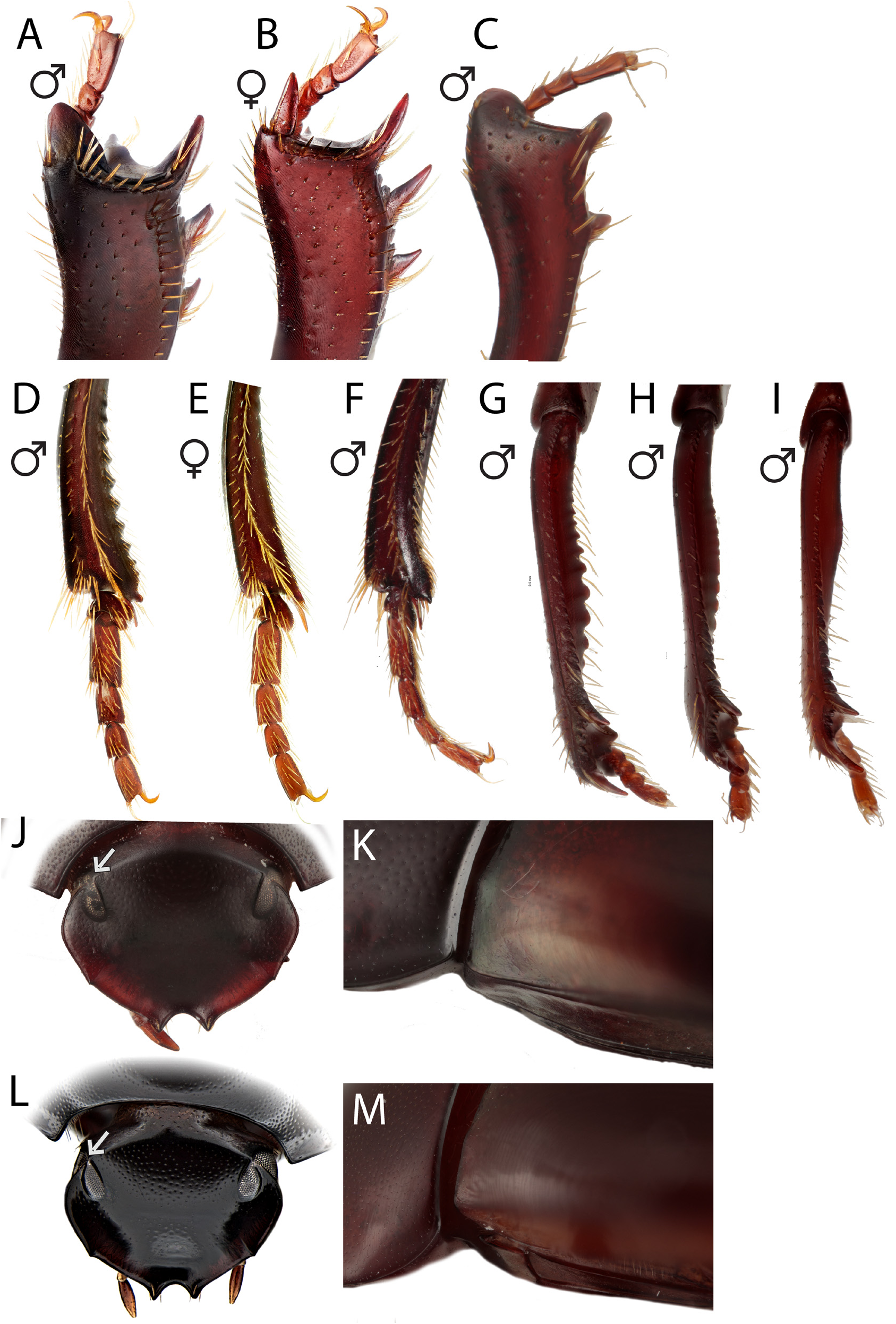
( Figs. 2C, H View FIGURE 2 , K–L; 3C; 4C; 5C; 7A–B)
Epilissus globulus Macleay, 1887: 222 View in CoL ; Gillet 1911: 38; Lea 1923: 353; Paulian 1934: 282.
Lepanus globulus: Matthews 1974: 106 View in CoL .
Type material examined. Lectotype: ♂ “Cairns N Queensl” / “ LECTOTYPE Epilissus globulus Macleay ” [RED] / “( LEFT) Lepanus globulus (Macl.) DET 1971 E. G Matthews LECTOTYPE ” / “specimen of Lepanus nitidus Math. on same card removed T. Weir 1977” / “On permanent loan from MACLEAY MUSEUM University of Sydney” / “ Epilissus globulus Macl. Cairns ” / “ ANIC Database 25 057888” in ANIC.
Other material examined. 1078 other specimens from over 150 unique localities were also examined.
Queensland: Shiptons Flat [15°47’00”S, 145°14’00”E], 16–18.v.1981, A. Calder & J.E. Feehan (25-058135 2 GoogleMaps specimens in ANIC); Shiptons Flat [15°47’00”S, 145°14’00”E], 17–19.x.1980, T.A. Weir (25-058136 3 specimens in ANIC) GoogleMaps ; Shiptons Flat [15°47’33”S, 145°13’51”E], 6.xii.1990 – 19.i.1991 (T44598–T44600 3 specimens in QM) GoogleMaps ; Shiptons Flat, via Helensvale [15°47’33”S, 145°13’51”E], 20–27.vii.1974 (T49771–T49779 9 specimens in QM) GoogleMaps ; Bloomfield Road, via Helensvale [15°47’45”S, 145°18’17”E], 2.v.1974 (T49765 1 specimen in QM) GoogleMaps ; Bloomfield Road, via Helensvale [15°47’45”S, 145°18’17”E], 20–27.vii.1974 (T49766–T49770 5 specimens in QM) GoogleMaps ; Mount Hartley , 2.5 km SW, 15°47’49”S, 145°19’34”E, 1.i.1994 – 5.iii.1994 (T44672–T44673 2 specimens in QM) GoogleMaps ; Shiptons Flat via Helensvale [15°48’00”S, 145°15’00”E], 240 m, 20–27.vii.1974, G.B. Monteith & D. Cook (25-015662 3 specimens in QM) GoogleMaps ; Shiptons Flat via Helensvale, ABRS Site 1 [15°48’00”S, 145°15’00”E], 198 m, 20–27.vii.1974, G.B. Monteith & D. Cook (25-015663 6 specimens in QM GoogleMaps ; Bloomfield Road via Helensvale, ABRS Site 3 [15°48’00”S, 145°19’00”E], 168 m, 2.v.1974, G.B. Monteith (25-015660 1 specimen in QM) GoogleMaps ; Bloomfield Road via Helensvale, ABRS Site 3 [15°48’00”S, 145°19’00”E], 168 m, 20–27.vii.1974, G.B. Monteith & D. Cook (25- 015661 5 specimens in QM) GoogleMaps ; Donovan Creek , 16°01’13”S, 145°26’38”E, 14.i–10.ii.1998, S. Grove (T73176– T73206 31 specimens in QM) GoogleMaps ; Donovan Creek , 16°01’13”S, 145°26’38”E, 10.ii–14.iii.1998, S. Grove (T85552– T85572 21 specimens in QM) GoogleMaps ; Donovan Creek , 16°01’13”S, 145°26’38”E, 14.iii–6.v.1998, S. Grove (T88852–T88854, T88859, T88863, T88866 –T88870 10 specimens in QM) GoogleMaps ; Donovan Creek , 16°01’13”S, 145°26’38”E, 10.ix–26.x.1998, S. Grove (T88855–T88858, T88860–T88862, T88864–T88865 9 specimens in QM) GoogleMaps ; Cape Tribulation area [16°04’00”S 145°28’00”E], 21–28.iii.1984, A. Calder & T.A. Weir (25-058141 2 specimens in ANIC) GoogleMaps ; Cape Tribulation [16°05’00”S, 145°27’00”E], 20 m, 9.v.1997, C. Reid (25-058184 1 specimen in ANIC) GoogleMaps ; Cape Tribulation transect Site 5A, 16°04’41”S, 145°27’0”E, 5–9.i.1983 (T55573 1 specimen in QM) GoogleMaps ; Cape Tribulation transect Site 5 [16°04’41”S, 145°27’13”E], 23.ix–7.x.1982 (T44754 1 specimen in QM) GoogleMaps ; Cape Tribulation transect Site 5 [16°04’41”S, 145°27’13”E], 20–23.iv.1983 (T44755 1 specimen in QM) GoogleMaps ; Cape Tribulation transect Site 4 [16°04’45”S, 145°27’20”E], 5–9.i.1983 (T44752 1 specimen in QM) GoogleMaps ; Cape Tribulation transect Site 4 [16°04’45”S, 145°27’20”E], 20–23.iv.1983 (T44753 1 specimen in QM) GoogleMaps ; Pilgrim Sands [16°04’S, 145°28’E], 19.xi–10.xii.1993 (T44741 1 specimen in QM) GoogleMaps ; Cape Tribulation transect Site 1 [16°04’12”S, 145°27’54”E], 23.iv.1983 (T44751 1 specimen in QM) GoogleMaps ; Cape Tribulation transect Site 1 [16°04’12”S, 145°27’54”E], 20–23.iv.1983 (T44756 1 specimen in QM) GoogleMaps ; Cape Tribulation transect Site 1 [16°04’12”S, 145°27’54”E], 23.ix–7.x.1982 (T55608– T55609 2 specimens in QM) GoogleMaps ; Cape Tribulation [16°05’00”S, 145°28’00”E], 10 m, 9.v.1997, C. Reid (25-058183 9 specimens in ANIC) GoogleMaps ; Cape Tribulation , 40 km N of Daintree [16°05’00”S, 145°29’00”E], 10 m, 12.vii.1982, S. & J. Peck (25-058131 2 specimens in ANIC) GoogleMaps ; Thompson Creek , 16°06’31”S, 145°26’25”E, 10.i–12.ii.1998, S. Grove (T73221–T73225 5 specimens in QM) GoogleMaps ; Thompson Creek , 16°06’31”S, 145°26’25”E, 19.xii.1998 – 16.i.1999, S. Grove (T85537 1 specimen in QM) GoogleMaps ; Thompson Creek , 16°06’31”S, 145°26’25”E, 12.ii–15.iii.1998, S. Grove, (T85555, T85542 2 specimens in QM) GoogleMaps ; Thompson Creek , 16°06’31”S, 145°26’25”E, 15.iii–7.v.1998, S. Grove (T88883, T88886 2 specimens in QM) GoogleMaps ; Thompson Creek , 16°06’31”S, 145°26’25”E, 11.ix–25.x.1998, S. Grove (T88884–88885, T88887–T88888 4 specimens in QM) GoogleMaps ; Noah Creek , 7 km ENE Thornton Peak [16°08’00”S 145°26’00”E], 27.iii.1984, A. Calder & T.A. Weir (25-058142 1 specimen in ANIC) GoogleMaps ; Oliver Creek (= Arsenic Creek ) [16°08’22”S, 145°26’24”E], 5–9.i.1983 (T55613 1 specimen in QM) GoogleMaps ; Noah Beach , 16°09’04”S, 145°26’27”E, 9.ix–10.x.1998, S. Grove (T73226–T73229 4 specimens in QM) GoogleMaps ; Noah Beach , 16°09’04”S, 145°26’27”E, 26.xii.1997 – 7.i.1998 (T73230–T85548, T85571 20 specimens in QM) GoogleMaps ; Noah Beach , 16°09’04”S, 145°26’27”E, 9.ii–15.iii.1998, (T85550–T85567, T85543, T88878 20 specimens in QM) GoogleMaps ; Noah Beach , 16°09’04”S, 145°26’27”E, 15.iii–7.v.1998 (T88873–T88874, T88879 3 specimens in QM) GoogleMaps ; Noah Beach , 16°09’04”S, 145°26’27”E, 9.ix–22.x.1998 (T88875 1 specimen in QM) GoogleMaps ; Noah Beach , 16°09’04”S, 145°26’27”E, collected 15.iii–7.v.1998 (T88876–T88877 2 specimens in QM) GoogleMaps ; Cooper Creek , 16°09’10”S, 145°24’19”E, 11.i–10.ii.1998 (T73172–T73175 4 specimens in QM) GoogleMaps ; Cooper Creek , 16°09’10”S, 145°24’19”E, 10.ii–16.iii.1998 (T85551– T85562 12 specimens in QM) GoogleMaps ; Cooper Creek , 16°09’10”S, 145°24’19”E 16.iii–7.v.1998 (T88880 1 specimen in QM) GoogleMaps ; Cooper Creek , 16°09’10”S, 145°24’19”E, 11.ix–24.x.1998 (T88881 1 specimen in QM) GoogleMaps ; 1.5 km SE Mount Emmett [16°10’00”S, 145°26’00”E], 23–24.iv.1999, C. Reid, (25-058172 1 specimen in ANIC) GoogleMaps ; Pimm’s Block , 16°11’20”S, 145°24’18”E, 8.i–9.ii.1998, S. Grove (T73216–T73220 5 specimens in QM) GoogleMaps ; Pimm’s Block , 16°11’20”S, 145°24’18”E, 9.ii–13.iii.1998, S. Grove (T85540–T85568 29 specimens in QM) GoogleMaps ; Pimm’s Block , 16°11’20”S, 145°24’18”E, 13.iii–8.v.1998, S. Grove (T88889–T88890 2 specimens in QM) GoogleMaps ; Cow Bay , N of Daintree River [16°12’00”S, 145°28’00”E], 25.x–15.xi.1987, R.I. Storey & Cunningham (25-058182 1 specimen in ANIC) GoogleMaps ; Cow Bay , N of Daintree River [16°12’00”S, 145°28’00”E], 6.ii–23.iii.1988, R.I. Storey & Cunningham (25-058181 1 specimen in ANIC) GoogleMaps ; Cow Bay , N of Daintree River [16°12’00”S, 145°28’00”E], 6.i–5.ii.1988, R.I. Storey & I. Cunningham (25-058180 4 specimens in ANIC) GoogleMaps ; Mangrove Road , 16°12’42”S, 145°25’18”E, 8.i– 9.ii.1998, S. Grove (T73207–T73214 8 specimens in QM) GoogleMaps ; Mangrove Road , 16°12’42”S, 145°25’18”E, 9.ii– 13.iii.1998, S. Grove (T85546–T85564 17 specimens in QM) GoogleMaps ; Mangrove Road , 16°12’42”S, 145°25’18”E, 9.ix– 25.x.1998, S. Grove (T88891–T88897 7 specimens in QM) GoogleMaps ; Mangrove Road , 16°12’42”S, 145°25’18”E, 13.iii–7.v.1998, S. Grove (T88898–T88900 3 specimens in QM) GoogleMaps ; Hutchinson Creek , 16°13’04”S, 145°23’57”E, 13.i–11.ii.1998, S. Grove (T73215 specimens in QM) GoogleMaps ; Hutchinson Creek , 16°13’04”S, 145°23’57”E, 14.iii–8.v.1998, S. Grove (T88882 1 specimen in QM) GoogleMaps ; Buchanan Creek , 16°14’39”S, 145°25’54”E, 5.i–11.ii.1998, S. Grove (T73168–T73171 4 specimens in QM) GoogleMaps ; Buchanan Creek , 16°14’39”S, 145°25’54”E, 11.ii–12.iii.1998, S. Grove (T85545 1 specimen in QM) GoogleMaps ; Buchanan Creek , 16°14’39”S, 145°25’54”E, 12.ix–23.x.1998, S. Grove (T88871 1 specimen in QM) GoogleMaps ; Buchanan Creek , 16°14’39”S, 145°25’54”E, 12.iii–8.v.1998, S. Grove (T88872 1 specimen in QM) GoogleMaps ; Fairy Creek , 16°14’16”S, 145°24’57”E, 11.ii–13.iii.1998, S. Grove (T85558–T85565 8 specimens in QM) GoogleMaps ; Fairy Creek , 16°14’16”S, 145°24’57”E, 13.iii–8.v.1998, S. Grove (T88843–T88851 9 specimens in QM) GoogleMaps ; Windsor Tableland, Bargoo Creek Road [16°14’51”S, 145°04’08”E], 15–18.iv.1982 (T44757 specimens in QM) GoogleMaps Windsor Tableland , 28 km NNW Mount Carbine, 16°17’05”S, 145°04’40”E, 15–18.iv.1982 (T44749 1 specimen in QM) GoogleMaps ; Wonga , 2 km N, 16°19’51”S, 145°25’05”E, 14–18.v.1998 (T66805 1 specimen in QM) GoogleMaps ; Devils Thumb transect Site 4, 16°23’39”S, 145°19’02”E, 26.xii.1989 – 15.i.1990 (T44826–T44827 2 specimens in QM) GoogleMaps ; Mossman Gorge National Park , [16°28’00”S, 145°21’00”E], 13–14.iv.1973, R.I. Storey, (25-058475 2 specimens in QM) GoogleMaps ; Rex Creek , site 1, 16°28’15”S, 145°19’30”E, 11.ii.2005 (T132288 1 specimen in QM) GoogleMaps ; Mossman Bluff Site 1, 16°28’19”S, 145°19’37”E, 1–16.i.1989 (T44767–T44775 9 specimens in QM) GoogleMaps ; Mossman Bluff Site 1, 16°28’19”S, 145°19’37”E 20.xii.1989 – 15.i.1990 (T44857–T44858 2 specimens in QM) GoogleMaps ; Rex Range , summit, 16°32’12”S, 145°22’44”E, 15– 18.v.1998 (T66803–T66804 2 specimens in QM) GoogleMaps ; Rex Creek , site 5, 16°28’23”S, 145°19’14”E, 21.xi.2005 (T132950 1 specimen in QM) GoogleMaps ; Mossman Bluff Site 4, 16°28’29”S, 145°18’09”E, 1–16.i.1989, (T44785–T44792 8 specimens in QM) GoogleMaps ; Mossman Bluff Site 4, 16°28’29”S, 145°18’09”E, 16–30.xii.1988 (T44793–T44799 7 specimens in QM) GoogleMaps ; Mossman Bluff Site 4, 16°28’29”S, 145°18’09”E, 20.xii–15.i.1990 (T44828–T44838 11 specimens in QM) GoogleMaps ; Mossman Bluff Site 2, 16°28’29”S, 145°19’03”E, 1–16.i.1989 (T44776–T44784 8 specimens in QM) GoogleMaps ; Mossman Bluff Site 2, 16°28’29”S, 145°19’03”E, 16–30.xii.1988 (T44811–T44818 8 specimens in QM) GoogleMaps ; Mossman Bluff Site 2, 16°28’29”S, 145°19’03”E, 20.xii.1989 – 15.i.1990 (T44851–T44856 6 specimens in QM) GoogleMaps ; Mossman Bluff Site 3, 16°28’35”S, 145°18’40”E, 1–16.i.1989 (T44759–T44766 8 specimens in QM) GoogleMaps ; Mossman Bluff Site 3, 16°28’35”S, 145°18’40”E, 16–30.xii.1988 (T44800–T44810 11 specimens in QM) GoogleMaps ; Mossman Bluff Site 3, 16°28’35”S, 145°18’40”E, 20.xii.1989 – 15.i.1990 (T44839–T44850 12 specimens in QM) GoogleMaps ; Mossman Gorge National Park , 6 km SW of Mossman [16°30’00”S, 145°20’00”E], 50 m, 11–18.vii.1982, S. Peck & J. Peck (25-058130 2 specimens in ANIC) GoogleMaps ; Mount Perseverance [16°32’00”S, 145°20’00”E], 500 m, 4.iv.1997, K. Abbott (25-058185 5 specimens in ANIC) GoogleMaps ; Rex Range , 16°32’02”S, 145°23’13”E, 430 m, 20–21.ix.2010, G.B. Monteith (25-060874 1 specimen also as COL 1139 in ANIC) GoogleMaps ; Julatten [16°34’02”S, 145°21’37”E], 8.ii.1983, A. Walford–Huggins (CMNEN-00030070 1 specimen in CMNC) GoogleMaps ; Clacherty Road via Julatten [16°34’19”S 145°21’52”E, 8.i–2.ii.1987, H. Howden & R.I. Storey (CMNEN-00030062, 00030197 2 specimens in CMNC) GoogleMaps ; Black Mountain Kuranda Forest Station [16°49’24”S, 145°39’13”E], 30–31.xii.1988, H. Howden & A. Howden (CMNEN-00030066 1 specimen in CMNC) GoogleMaps ; Julatten [16°37’00”S, 145°20’00”E], 10–29.ix.1987, A. Walford-Huggins (25-058139 2 specimens in ANIC) GoogleMaps ; Julatten [16°37’00”S, 145°20’00”E], 20–29.x.1987, A. Walford-Huggins (25-058148 1 specimen in ANIC) GoogleMaps ; Julatten [16°37’00”S, 145°20’00”E], 29.x–21.xi.1987, A. Walford-Huggins (25-058138 1 specimen in ANIC) GoogleMaps ; Julatten [16°37’00”S, 145°20’00”E], 30.xi–13.xii.1987, A. Walford-Huggins (25-058147 1 specimen in ANIC) GoogleMaps ; Julatten [16°37’00”S, 145°20’00”E], 5–20.x.1987, A. Walford-Huggins (25-058146 1 specimen in ANIC) GoogleMaps ; Black Mountain , lower slopes, 16°39’52”S, 145°30’04”E, 2.xii.1997 – 6.ii.1998 (T57475–T57478 4 specimens in QM) GoogleMaps ; Quaid Road, Mareeba , 16°44’11”S, 145°28’37”E, 17.iii–14.iv.1998, De Faveri & K.H. Halfpapp (25-058563 3 specimens in QDPC) GoogleMaps ; 5 km NNW of Kuranda [16°45’00”S, 145°37’00”E], 15.i–20.ii.1985, R.I. Storey & K.H. Halfpapp (25- 058164 1 specimen in ANIC) GoogleMaps ; 4 km NNW of Kuranda [16°47’00”S, 145°37’00”E], 10.xii.1984 – 15.i.1985, R.I. Storey & K.H. Halfpapp (25-058156 2 specimens in ANIC) GoogleMaps ; Kuranda St. Forest , 3 km N Kuranda [16°49’00”S, 145°38’00”E], 360 m, 25.vi–3.viii.1982, S. Peck & J. Peck (25-058129 3 specimens in ANIC) GoogleMaps ; Saddle Mountain , summit, 16°49’11”S, 145°39’42”E, 10.xii.1995 – 2.ii.1996 (T44544–T44548 5 specimens in QM) GoogleMaps ; Saddle Mountain , summit, 16°49’11”S, 145°39’42”E, 3.xi–10.xii.1995 (T44549–T44550 2 specimens in QM) GoogleMaps ; 8 km SW Kuranda [16°52’00”S, 145°34’00”E], iii.1993, G. O’Reilly (25-060765 1 specimen also as COL 741 in AM) GoogleMaps ; 6 km SW of Kuranda , [16°52’00”S, 145°37’00”E], 10.xii.1984 – 15.i.1985, R.I. Storey & K.H. Halfpapp (25-058157 3 specimens in ANIC) GoogleMaps ; 6 km SW of Kuranda [16°52’00”S, 145°37’00”E], 15.i–20.ii.1985, R.I. Storey & K.H. Halfpapp (25-058155 4 specimens in ANIC) GoogleMaps ; 6 km SW of Kuranda [16°52’00”S, 145°37’00”E], 20.ii–20.iii.1985, R.I. Storey & K.H. Halfpapp (25-032566 1 specimen in QDPC) GoogleMaps ; 6 km SW of Kuranda [16°52’00”S, 145°37’00”E], 20.ix– 6.xi.1984, R.I. Storey & K.H. Halfpapp (25-032565 1 specimen in QDPC, 25-058168 1 specimen in ANIC) GoogleMaps ; 6 km SW of Kuranda [16°52’00”S, 145°37’00”E], 6.xi–10.xii.1984, R.I. Storey & K.H. Halfpapp (25-032564 1 specimen in QDPC) GoogleMaps ; Mount Williams summit, 16°54’53”S, 145°39’43”E, 27.xi.1997 – 10.ii.1998 (T57468–T57474 7 specimens in QM) GoogleMaps ; Mount Williams summit, 16°54’53”S, 145°39’43”E, 27–28.xi.1997 (T57482–T57483 2 specimens in QM) GoogleMaps ; Cedar Pocket , [16°56’00”S, 145°36’00”E], 440 m, 17–19.iv.1999, C. Reid & I. Reid (25-058174 1 specimen in ANIC) GoogleMaps ; Whitfield Range , 16°57’33”S, 145°42’31”E, 28.viii–19.x.1991 (T44824 1 specimen in QM) GoogleMaps ; Pine Creek Tower , 16°59’36”S, 145°50’07”E, 12.ix–20.x.1991 (T44739–T44740 2 specimens in QM) GoogleMaps ; Lambs Head , 20 km SW Cairns, 17°01’23”S, 145°38’33”E, 4–13.xii.1988 (T44671 1 specimen in QM) GoogleMaps ; Davies Creek Road, via Mareeba , 17°02’33”S, 145°36’51”E, 4–13.xii.1988 (T44696–T44710 15 specimens in QM) GoogleMaps ; Mount Haig [17°06’00”S, 145°36’00”E], 1150 m, 1.xii.1994 – 3.i.1995, P. Zborowski (25-058179 1 specimen in ANIC) GoogleMaps ; Robson Creek, Atherton [17°07’00”S, 145°37’00”E], 18.i.1996, R.J. Kitching & H. Mitchell (25-058150 1 specimen in ANIC) GoogleMaps ; Robson Creek Atherton [17°07’00”S, 145°37’07”E], 17.i.1996, R.J. Kitching & H. Mitchell (25-058186 1 specimen in ANIC) GoogleMaps ; Robson Creek Atherton [17°07’00”S, 145°37’07”E], 18.i.1996, R.J. Kitching & H. Mitchell (25-058187 1 specimen in ANIC) GoogleMaps ; Danbulla State Forest, Kauri Creek Trail, Tinaroo Lake , 17°08’03”S, 145°35’52”E, 625 m, 24.i.2000, R.A. Anderson (CMNEN-00030059 1 specimen in CMNC) GoogleMaps ; Tinaroo Dam Drive , 17°08’31”S, 145°35’24”E, 3–4.xii.2010, G.B. Monteith (25-060830 1 specimen in ANIC aslo as COL1462) GoogleMaps ; 17 km NE Yungaburra [17°09’40”S, 145°37’56”E], 21.xii.1986, H. Howden & A. Howden (CMNEN-00030051, 00030053 2 specimens in CMNC) GoogleMaps ; Lake Euramoo , 17°09’46”S, 145°37’38”E, 10–11.ii.1999 (T76207 1 specimen in QM) GoogleMaps ; Danbulla State Forest , 13 km NE of Yungaburra [Danbulla Forestry Reserve] [17°10’00”S, 145°38’00”E], 13.ii–6.iii.1987, R.I. Storey & De Faveri (25-032574 1 specimen in QDPC, 25-058165 1 specimen in ANIC) GoogleMaps ; Danbulla State Forest , 13 km NE of Yungaburra [Danbulla Forestry Reserve] [17°10’00”S, 145°38’00”E], 20.xii.1986 – 13.i.1987, R.I. Storey & De Faveri (25-032573 1 specimen in QDPC) GoogleMaps ; Danbulla State Forest , 13 km NE of Yungaburra [Danbulla Forestry Reserve] [17°10’00”S, 145°38’00”E], 23.iv–27.v.1987, R.I. Storey & De Faveri (25-058166 1 specimen in ANIC) GoogleMaps ; Danbulla State Forest , 13 km NE of Yungaburra [Danbulla Forestry Reserve] [17°10’00”S, 145°38’00”E], 23.vi–28.vii.1987, R.I. Storey & De Faveri (25-058167 1 specimen in ANIC) GoogleMaps ; Danbulla State Forest , 13 km NE of Yungaburra [Danbulla Forestry Reserve] [17°10’00”S, 145°38’00”E], 26.iii–23.iv.1987, R.I. Storey & De Faveri (25-032575 1 specimen in QDPC) GoogleMaps ; Boar Pocket Road 3.9 m. N, [17°10’00”S, 145°39’00”E], 2500 feet, 4.viii.1974, J.G. Brooks (25-057895 1 specimen in ANIC) GoogleMaps ; upper Mulgrave River [17°10’00”S, 145°53’00”E], 2.iv.1968, E. Matthews (25-057890 1 specimen in ANIC) GoogleMaps ; Cathedral Tree , 17°10’37”S, 145°39’36”E, 3–4.xii.2010, G.B. Monteith, (25-057622 7 specimens in ANIC) GoogleMaps ; Cathedral Tree , 17°10’37”S, 145°39’36”E, 4–5.xii.2010, G.B. Monteith (25-057621 2 specimens in ANIC) GoogleMaps ; Cathedral Fig , 17°10’52”S, 145°39’26”E, 7.ii.1996 (T44588–T44589 2 specimens in QM) GoogleMaps ; Danbulla Scientific Reserve , 17°11’09”S, 145°39’36”E, 10.xii.1995 – 7.ii.1996 (T44601–T44606, T44670, T47307–T47311 13 specimens in QM) GoogleMaps ; Boar Pocket Road [17°12’00”S, 145°40’09”E], xi.1969, J.G. Brooks (CMNEN-00030063 1 specimen in CMNC) GoogleMaps ; Boar Pocket Road [17°12’00”S, 145°40’09”E], 20.x.1974, J.G. Brooks (CMNEN-00030064–00030065 2 specimens in CMNC) GoogleMaps ; Boar Pocket Road [17°12’00”S, 145°40’09”E], 27.i.1975, J.G. Brooks (CMNEN-00030071–00030072 2 specimens in CMNC) GoogleMaps ; Boar Pocket Road [17°12’00”S, 145°40’09”E], viii.1974, J.G. Brooks (CMNEN-00030068 1 specimen in CMNC) GoogleMaps ; Boar Pocket Road [17°12’00”S, 145°42’00”E], 2540 feet, 8.xii.1974, J.G. Brooks (25-057893 1 specimen in ANIC) GoogleMaps ; Boar Pocket Road [17°12’00”S, 145°42’00”E], 21.ii.1970, J.G. Brooks (25-057896 1 specimen in ANIC) GoogleMaps ; Gillies Highway [17°12’00”S, 145°42’00”E], 2760 feet, 24.xi.1974, J.G. Brooks (25-057892 1 specimen in ANIC) GoogleMaps ; Gillies Road , 16 km NE Yungaburra [17°12’00”S, 145°42’00”E], 800 m, 24.vi–3.viii.1982, S. Peck & J. Peck (25-058128 1 specimen in ANIC) GoogleMaps ; Tolga Scrub [17°14’00”S, 145°28’00”E], 760 m, 17–19.iv.1999, C. Reid & I. Reid (25-058171 2 specimens in ANIC) GoogleMaps ; Tolga Scrub [17°14’42”S, 145°28’45”E], 23–24.ii.2001 (T106785–T106786 2 specimens in QM) GoogleMaps ; Tolga , 17°14’06”S, 145°28’45”E, 9.xii.1989 – 14.i.1990 (T44699–T44702 4 specimens in QM) GoogleMaps ; Tolga Scrub [17°14’42”S, 145°28’45”E], 3–6.ii.1999 (T76202–T76214 13 specimens in QM) GoogleMaps ; Lake Barrine , 17°14’46”S, 145°38’24”E, 750 m, 17.xi.2009, G.B. Monteith & F. Turco (25-060784 1 specimen in ANIC also as COL774) GoogleMaps ; Barrine National Park [17°15’00”S, 145°38’00”E], 760 m, 21.iii.1975, R.W. Taylor (25-057891 1 specimen in ANIC) GoogleMaps ; Gadgarra State Forest , 10 km E Lake Eacham, 17°15’30”S, 145°41’16”E, 9–31.xii.1989 (T44746–T44747 2 specimens in QM) GoogleMaps ; Yungaburra [17°16’00”S, 145°35’00”E], 7.v.1969, G. Bornemissza & P. Ferrar (25-057889 3 specimens in ANIC) GoogleMaps ; Wrights Creek, Lake Eacham [17°16’00”S, 145°37’00”E], 750 m, 31.vii.1982, S. Peck & J. Peck (25-058132 1 specimen in ANIC) GoogleMaps ; Mulgrave River Road, 7 km WbyS Bellenden Ker [17°16’00”S, 145°47’00”E], 60 m, 2.iv.1984, A.Calder & T.A.Weir (25-058140 3 specimens in ANIC) GoogleMaps ; Bellenden Ker Range, Cableway Base Station [17°16’00”S, 145°54’00”E], 100 m, 17.x–9.xi.1981, Earthwatch, Queensland Museum (25-058133 1 specimen in ANIC) GoogleMaps ; Bellenden Ker Range , 0.5 km S Cable Tower 7 [17°16’00”S, 145°55’00”E], 500 m, 25–31.x.1981, Earthwatch, Queensland Museum (25-058134 1 specimen in ANIC) GoogleMaps ; 2 mi. S of Yungaburra [17°17’00”S, 145°33’00”E], 16– 18.iv.1973, R.I. Storey (25-058474 4 specimens in QM) GoogleMaps ; Curtain Fig [17°17’00”S, 145°34’00”E], 700 m, 20– 21.iv.1999, C. Reid & I. Reid (25-058173 1 specimen in ANIC) GoogleMaps ; Lake Eacham , 17°16’59”S, 145°37’28”E, 9.xii.1989 – 14.i.1990 (T44819–T44821 3 specimens in QM) GoogleMaps ; Peeramon Scrub , 17°18’43”S, 145°37’34”E, 2.xi– 10.xii.1995 (T44607–T44609 3 specimens in QM) GoogleMaps ; Peeramon Scrub , 17°18’43”S, 145°37’34”E, 10.xii.1995 – 7.ii.1996 (T44610–T44620 11 specimens in QM) GoogleMaps ; Lake Eacham via Yungaburra , [17°17’00”S, 145°36’00”E], 14– 15.iv.1973, R.I. Storey (25-058472 2 specimens in QM) GoogleMaps ; Lake Eacham [17°17’00”S, 145°37’00”E], 14.xi.1998 (25-057902 1 specimen in ANIC) GoogleMaps ; Lake Eacham National Park [17°17’00”S, 145°38’00”E], 2–5.ii.1998, T.A. Weir (25-057901 2 specimens in ANIC) GoogleMaps ; Wongabel State Forest , 6 km S of Atherton [17°18’00”S, 145°31’00”E], 1.xii.1983 – 9.i.1984, R.I. Storey & Brown (25-032555 2 specimens in QDPC) GoogleMaps ; Wongabel State Forest , 6 km S of Atherton [17°18’00”S, 145°31’00”E], 1.xii.1983 – 9.i.1984, R.I. Storey & Brown (25-032561 1 specimen in QDPC) GoogleMaps ; Wongabel State Forest , 6 km S of Atherton [17°18’00”S, 145°31’00”E], 1.v–21.vi.1984, R.I. Storey & Brown (25- 032560 1 specimen in QDPC) GoogleMaps ; Wongabel State Forest , 6 km S of Atherton [17°18’00”S, 145°31’00”E], 10.ii– 13.iii.1984, R.I. Storey & Brown (25-032556 2 specimens in QDPC, 25-032558 2 specimens in QDPC) GoogleMaps ; Wongabel State Forest , 6 km S of Atherton [17°18’00”S, 145°31’00”E], 10.xi–1.xii.1983, R.I. Storey & Brown (25-032582 1 specimen in QDPC, 25-032584 1 specimen in QDPC) GoogleMaps ; Wongabel State Forest , 6 km S of Atherton [17°18’00”S, 145°31’00”E], 13.iii–1.v.1984, R.I. Storey & Brown (25-032559 1 specimen in QDPC) GoogleMaps ; Wongabel State Forest , 6 km S of Atherton [17°18’00”S, 145°31’00”E], 3.ix–1.xi.1984, R.I. Storey & Brown (25-058149 4 specimens in ANIC, 25-058169 2 specimens in ANIC) GoogleMaps ; Wongabel State Forest , 6 km S of Atherton [17°18’00”S, 145°31’00”E], 9.i–10.ii.1984, R.I. Storey & Brown (25-032557 2 specimens in QDPC, 25-032583 1 specimen in QDPC) GoogleMaps ; Peeramon Scrub via Yungaburra [17°19’00”S, 145°36’00”E], 14–17.iv.1973, R.I. Storey (25-058473 1 specimen in QM) GoogleMaps ; Wongabel State Forest , N end, 17°19’07”S, 145°29’37”E, 23–24.ii.2001 (T106782–T106784 3 specimens in QM) GoogleMaps ; Wongabel State Forest , 17°19’29”S, 145°29’50”E, 5–14.xii.1988 (T44693–T44695 3 specimens in QM) GoogleMaps ; Wongabel State Forest , 17°19’52”S, 145°30’04”E, 770 m, 22–23.i.2012, G.B. Monteith (25-053844, 25-055606 2 specimens in ANIC) GoogleMaps ; Wongabel State Forest [17°20’02”S, 145°30’00”E], 760 m, 18–19.ix.2010, G.B. Monteith (25-060873 1 specimen in ANIC also as COL1138) GoogleMaps ; Malanda Falls [17°21’00”S, 145°35’00”E], 14.v.1974, R.I. Storey (25-032587 1 specimen in QDPC) GoogleMaps ; Malanda Falls , 17°21’22”S, 145°35’10”E, 750 m, 15–16.ix.2010, G.B. Monteith (25-060871 1 specimen in ANIC also as COL1136) GoogleMaps ; Malanda Falls , 17°21’22”S, 145°35’10”E, 750 m, 23–24.i.2012, G.B. Monteith, (25-053846, 25-055610 2 specimens in ANIC) GoogleMaps ; Bartle Frere , west base, 17°22’47”S, 145°45’51”E, 25.xi.1994 – 10.i.1995 (T44859–T44860, T47357 3 specimens in QM) GoogleMaps ; Bartle Frere , west base, 17°22’47”S, 145°45’51”E, 7.iii–15.v.1995 (T44859–T44867, T74356 10 specimens in QM) GoogleMaps ; Bartle Frere , west base, 17°22’47”S, 145°45’51”E, 8.xii.1988 (T44733 1 specimen in QM) GoogleMaps ; 2 km NNE Tarzali [17°24’00”S, 145°36’00”E], 740 m, 18–20.iv.1999, C. Reid & I. Reid (25-058176 1 specimen in ANIC) GoogleMaps ; Topaz, Pei Road, ( Frith house), 17°24’23”S, 145°41’05”E, 6.xii.1993 – 25.ii.1994 (T44675–T44682 6 specimens in QM) GoogleMaps ; Topaz, Westcott Road ( Cooper house), 17°24’49”S, 145°41’59”E, 6.xii.1993 – 25.ii.1994 (T44822, T47349–T47350 3 specimens in QM) GoogleMaps ; Hugh Nelson Range , 21 km S of Atherton [17°25’00”S, 145°28’00”E], 12.x–5.xi.1983, R.I. Storey & Brown (25-032585 1 specimen in QDPC) GoogleMaps ; Hugh Nelson Range , 21 km S of Atherton [17°25’00”S, 145°28’00”E], 13.iii–1.v.1984, R.I. Storey & Brown (25- 032577 2 specimens in QDPC) GoogleMaps ; Hugh Nelson Range , 21 km S of Atherton [17°25’00”S, 145°28’00”E], 5.xi– 1.xii.1983, R.I. Storey & Brown (25-032576 1 specimen, 25-032586 1 specimen in QDPC) GoogleMaps ; The Crater National Park [17°25’00”S, 145°29’00”E], 16–18.iv.1973, R.I. Storey (25-058471 10 specimens in QM) GoogleMaps ; The Crater , 17°25’43”S, 145°29’13”E, 26.xi.1992 – 15.iv.1993 (T106771–T106781 11 specimens in QM) GoogleMaps ; Crater National Park (= Mout Hypipamee National Park ) [17°26’00”S, 145°29’00”E], 25.i.1972, J.G. Brooks (25-057897 1 specimen in ANIC) GoogleMaps ; Topaz, Hughes Road ( Breeden house), 17°26’04”S, 145°42’02”E, 6.xii.1993 – 25.ii.1994 (T44687–T44690 4 specimens in QM) GoogleMaps ; Stone Creek , 17°27’40”S, 146°01’04”E, 1.xi.1995 – 6.ii.1996, J. Hasenpusch (T44732 1 specimen in QM) GoogleMaps ; Tower S of Crater National Park, 17°27’23”S, 145°29’12”E, 10.i–31.iii.1995 (T44674 1 specimen in QM) GoogleMaps ; Tower S of Crater National Park, 17°27’23”S, 145°29’12”E, 25.xi.1994 – 10.i.1995 (T47344 1 specimen in QM) GoogleMaps ; Longlands Gap [17°28’00”S, 145°29’00”E], 1150 m, 3.i–4.ii.1995, P. Zborowski (25-058178 1 specimen in ANIC) GoogleMaps ; Kenny Road, Atherton Tablelands , 17°28’13”S, 145°32’04”E, 10.i–31.iii.1995 (T44683–T44709 17 specimens in QM) GoogleMaps ; Kenny Road, Atherton Tablelands , 17°28’13”S, 145°32’04”E, 25.xi.1994 – 10.i.1995 (T47338–T47343 6 specimens in QM) GoogleMaps ; Millaa Millaa Falls , 17°29’53”S, 145°36’32”E, 5.v.1983 (T44758 1 specimen in QM) GoogleMaps ; Millaa Millaa Falls , [17°30’00”S, 145°36’00”E], 780 m, 23–25.i.2012, G.B. Monteith (25-055611 1 specimen in ANIC) GoogleMaps ; above Millaa Millaa Falls , 17°29’53”S, 145°36’47”E, 830 m, 23–25.i.2012, G.B. Monteith (25-053845 2 specimens in ANIC, 25-055608 2 specimens in ANIC) GoogleMaps ; Millaa Millaa Falls (above), [17°30’00”S, 145°36’00”E], 800 m, 18– 20.iv.1999, C. Reid & I. Reid (25-058175 1 specimen in ANIC) GoogleMaps ; Millaa Millaa Falls , [17°30’00”S, 145°37’00”E], 760 m, 11.v.1974, R.I. Storey (25-032579 1 specimen in QDPC) GoogleMaps ; Millaa Millaa Falls [17°30’00”S, 145°37’00”E], 760 m, 13.vii–15.viii.1990, R.I. Storey & K.H. Halfpapp (25-032553 1 specimen in QDPC) GoogleMaps ; Millaa Millaa Falls [17°30’00”S, 145°37’00”E], 760 m, 13.iii–10.iv.1990, R.I. Storey & K.H. Halfpapp (25-032552 3 specimens in QDPC GoogleMaps ; Millaa Millaa Falls [17°30’00”S, 145°37’00”E], 760 m, 15.viii–12.ix.1990, R.I. Storey & K.H. Halfpapp (25-032554 1 specimen in QDPC) GoogleMaps ; Millaa Millaa Falls , [17°30’00”S, 145°37’00”E], 760 m, 4.1– 7.ii.1990, R.I. Storey & K.H. Halfpapp (25-032549 7 specimens in QDPC) GoogleMaps ; Millaa Millaa Falls [17°30’00”S, 145°37’00”E], 760 m, 7.ii–13.iii.1990, R.I. Storey & K.H. Halfpapp (25-032550–032551 2 specimens in QDPC) GoogleMaps ; Mount Hugh Nelson, S base, 17°31’00”S, 145°33’15”E, 7–9.ii.1999 (T76218 1 specimen in QM) GoogleMaps ; Mount Hugh Nelson S base[17°31’00”S, 145°33’00”E], 1080 m, 7–9.ii.1999, G.B. Monteith & D. Cook (25-060845 1 specimen also as COL 584 in ANIC) GoogleMaps ; Tom Carrick Road , 17°31’55”S, 145°30’50”E, 1070 m, 18–19.ix.2010, G.B. Monteith (25-060872 1 specimen in ANIC also as COL1137) GoogleMaps ; Kjellberg Road turnoff, 17°31’57”S, 145°36’27”E, 7.iii–15.v.1995 (T44621–T44632 12 specimens in QM) GoogleMaps ; Kjellberg Road turnoff, 17°31’57”S, 145°36’27”E, 10.i–31.iii.1995 (T44633–T44660, T55897 28 specimens in QM) GoogleMaps ; Kjellberg Road turnoff, 17°31’57”S, 145°36’27”E, 25.xi.1994 – 10.i.1995 (T44661–T44666, T47301–T47306 13 specimens in QM) GoogleMaps ; The Millstream , 10 km NNE Ravenshoe, 17°31’57”S, 145°30’45”E, 6.xii.1998 – 5.ii.1999 (T76208–T76209 2 specimens in QM) GoogleMaps ; Sluice Creek , 17°32’24”S, 145°31’56”E, 1.xii.1993 – 25.ii.1994 (T44667–T44669 3 specimens in QM) GoogleMaps ; Sluice Creek , 17°32’24”S, 145°31’56”E, 5.ii–15.iv.1999 (T79114 1 specimen in QM) GoogleMaps ; Mount Fisher, Kjellberg Road , 17°32’34”S, 145°33’31”E, 1.xii.1993 – 25.ii.1994 (T44691– T44692 2 specimens in QM) GoogleMaps ; Mount Fisher, Kjellberg Road , 17°32’34”S, 145°33’31”E, 27.iv.1982 (T44703 1 specimen in QM) GoogleMaps ; Mount Fisher, Kjellberg Road , 17°32’34”S, 145°33’31”E, 8.xii.1989 (T54145 1 specimen in QM) GoogleMaps ; Palmerston National Park , west boundary, 17°33’36”S, 145°41’15”E, 1.xii.1993 – 25.ii.1994 (T44744–T44745 2 specimens in QM) GoogleMaps ; Beatrice River , 2 km S, 17°34’35”S, 145°41’25”E, 1.xii.1993 – 25.ii.1994 (T44823 1 specimen in QM) GoogleMaps ; Palmerston Forestry turnoff, 17°35’20”S, 145°42’14”E, 700 m, 15–16.ix.2010, G.B. Monteith (25-060868 2 specimens in ANIC also as COL1128–29) GoogleMaps ; Maalan State Forest, Ravenshoe Road , 17°35’23”S, 145°35’40”E, 7.iii–15.v.1995 (T44551–T44562 12 specimens in QM) GoogleMaps ; Maalan State Forest, Ravenshoe Road , 17°35’23”S, 145°35’40”E, 10.i–31.iii.1995 (T44563–T44573 11 specimens in QM) GoogleMaps ; Maalan State Forest, Ravenshoe Road , 17°35’23”S, 145°35’40”E, 25.xi.1994 – 10.i.1995 (T44574–T44587, T47345 15 specimens in QM) GoogleMaps ; Maalan State Forest, Ravenshoe Road , 17°35’23”S, 145°35’40”E, 10.i–31.iii.1995 (T47346–T47348 3 specimens in QM) GoogleMaps ; Maalan State Forest, Ravenshoe Road , 17°35’23”S, 145°35’40”E, 6–9.ii.1999 (T76216–T76217 2 specimens in QM) GoogleMaps ; Mount Father Clancy , 2 km W, 17°35’30”S, 145°36’45”E, 25.vii–26.xi.1992 (T111993 1 specimen in QM) GoogleMaps ; Maalan Road , 2 km S Palmerston Highway, 17°35’56”S, 145°41’58”E, 7.iii–15.v.1995 (T44485–T44513 19 specimens in QM) GoogleMaps ; Maalan Road , 2 km S Palmerston Highway, 17°35’56”S, 145°41’58”E, 10.i–7.iii.1995 (T44514–T44527, T47312–T47325 28 specimens in QM) GoogleMaps ; Maalan Road , 2 km S Palmerston Highway, 17°35’56”S, 145°41’58”E, 26.xi.1994 – 10.i.1995 (T44528–T44543, T47326 View Materials –T47337 28 specimens in QM) GoogleMaps ; Henrietta Creek, Palmerston National Park , 17°35’58”S, 145°45’28”E, 30.xi.1992 – 15.iv.1993 (T111990–T111992 3 specimens in QM) GoogleMaps ; Mount Father Clancy , 800 m, 17°35’58”S, 145°38’04”E, 6–14.xii.1988 (T44704–T44708 5 specimens in QM) GoogleMaps ; Mount Father Clancy , 1000 m, 17°35’25”S, 145°38’04”E, 6.xii.1988 (T44825 1 specimen in QM) GoogleMaps ; South Johnstone Research Station [17°36’00”S, 145°58’00”E], 11.x–29.xi.1990, K.H. Halfpapp (25-032562 1 specimen in QDPC) GoogleMaps ; South Johnstone Research Station [17°36’00”S, 145°58’00”E], 29.xi.1989 – 14.i.1990, K.H. Halfpapp (25-032563 1 specimen in QDPC) GoogleMaps ; Palmerston National Park , east margin, 17°36’40”S, 145°45’48”E, 10.xii.1995 – 7.ii.1996 (T44742–T44743 2 specimens in QM) GoogleMaps ; Wooroonooran National Park, Patterson Sector, Tchupala Falls Trail, 17°36’25”S, 145°46’44”E, 22.i.2000, R.A. Anderson (CMNEN-00030060–00030061 2 specimens in CMNC) GoogleMaps ; Wooroonooran National Park Patterson Sector, Crawfords Lookout , 17°36’46”S, 145°46’36”E, 550 m, 22.i.2000, R.A.Anderson (CMNEN-00030054–00030058 5 specimens in CMNC) GoogleMaps ; Massey Creek [17°37’00”S, 145°34’00”E], 1000 m, 1.xii.1994 – 3.i.1995, P. Zborowski, (25-058177 4 specimens in ANIC) GoogleMaps ; South Johnstone Forestry Camp , 5 km W, 17°38’12”S, 145°40’15”E, 1.xii.1993 – 25.ii.1994 (T44590–T44597 8 specimens in QM) GoogleMaps ; Vine Creek, Majors Mountain , 17°40’58”S, 145°32’02”E, 15–18.iv.1999 (T79115 1 specimen in QM) GoogleMaps ; Charmillin Creek crossing [17°42’03”S, 145°31’21”E], 8.xii.1989 – 5.i.1990 (T47353–T47355 3 specimens in QM) GoogleMaps ; Charmillin Creek crossing [17°42’03”S, 145°31’21”E], 1.xii.1997 (T57479 1 specimen in QM) GoogleMaps ; Charmillin Creek crossing [17°42’03”S, 145°31’21”E], 5–11.ii.1998 (T57480–T57481, T60417 3 specimens in QM) GoogleMaps ; Charmillin Creek crossing [17°42’03”S, 145°31’21”E], 2–5.xii.1998 (T70928 1 specimen in QM) GoogleMaps ; Charmillin Creek , 17°42’54”S, 145°31’34”E, 880 m, 18–19.ix.2010, G.B. Monteith (25-060875 1 specimen in ANIC also as 1140) GoogleMaps ; Ravenshoe State Forest, Tully Falls Road [17°43’00”S, 145°33’00”E], 10.x–15.xi.1987, A. Walford-Huggins (25-057898 5 specimens in ANIC, 25- 058145 1 specimen in ANIC) GoogleMaps ; Ravenshoe State Forest, Tully Falls Road [17°43’00”S, 145°33’00”E], 15.xi– 12.xii.1987, A. Walford-Huggins (25-057899 11 specimens in ANIC, 25-058137 2 specimens in ANIC) GoogleMaps ; Tully Falls State Forest , 18 km SSW Ravenshoe [17°46’00”S, 145°31’00”E], 730 m, 1.x–5.xi.1987, R.I. Storey & Dickinson (25-058163 1 specimen in ANIC) GoogleMaps ; Tully Falls State Forest , 18 km SSW Ravenshoe [17°46’00”S, 145°31’00”E], 730 m, 20.iv–25.v.1988, R.I. Storey & Dickinson (25-058151 4 specimens in ANIC) GoogleMaps ; Tully Falls State Forest , 18 km SSW Ravenshoe [17°46’00”S, 145°31’00”E], 730 m, 3.iii–20.iv.1988, R.I. Storey & Dickinson (25-032571 1 specimen in QDPC) GoogleMaps ; Tully Falls State Forest , 18 km SSW Ravenshoe [17°46’00”S, 145°31’00”E], 730 m, 5.i– 7.ii.1988, R.I. Storey & Dickinson (25-032569 1 specimen in QDPC, 25-058158 1 specimen in ANIC) GoogleMaps ; Tully Falls State Forest , 18 km SSW Ravenshoe [17°46’00”S, 145°31’00”E], 730 m, 7.xii.1987 – 7.i.1988, R.I. Storey & Dickinson (25-058154 3specimens in ANIC) GoogleMaps ; Tully Falls State Forest , 18 km SSW Ravenshoe [17°46’00”S, 145°31’00”E], 730 m, 7.xi–7.xii.1987, R.I. Storey & Dickinson (25-058153 2 specimens in ANIC) GoogleMaps ; Tully Falls State Forest , 11 km SSW Ravenshoe [17°47’00”S, 145°34’00”E], 900 m, 1.x–5.xi.1987, R.I. Storey & Dickinson (25-032567 2 specimens in QDPC) GoogleMaps ; Tully Falls State Forest , 11 km SSW Ravenshoe [17°47’00”S, 145°34’00”E], 900 m, 5.i–7.ii.1988, R.I. Storey & Dickinson (25-058161 1 specimen in ANIC) GoogleMaps ; Tully Falls State Forest , 11 km SSW Ravenshoe [17°47’00”S, 145°34’00”E], 900 m, 5.xi–7.xii.1987, R.I. Storey & Dickinson (25-058159 1 specimen in ANIC, 25- 032568 2 specimens in QDPC) GoogleMaps ; Tully Falls State Forest , 11 km SSW Ravenshoe [17°47’00”S, 145°34’00”E], 900 m, 7.xii.1987 – 7.i.1988, R.I. Storey & Dickinson (25-058162 1 specimen in ANIC) GoogleMaps ; Tully Falls , 30 mi. NE of Tully, [17°42’03”S, 145°59’19”E], 2500 feet, 5.vi.1972, G. Monteith & S.R. Monteith (CMNEN–00030069 1 specimen in CMNC) GoogleMaps ; Tully Falls State Forest , 9.5 km SSW Ravenshoe [17°47’00”S, 145°34’00”E], 1000 m, 5.xi–7.xii.1987, R.I. Storey & Dickinson (25-058160 1 specimen in ANIC) GoogleMaps ; Tully Falls State Forest , 9.5 km SSW Ravenshoe [17°47’00”S, 145°34’00”E], 1000 m, 7.i–9.ii.1988, R.I. Storey & Dickinson (25-058152 3 specimens in ANIC) GoogleMaps ; Tully Falls via Ravenshoe [17°47’00”S, 145°34’00”E], 20–21.iv.1973, R.I. Storey (25-032588 1 specimen in QDPC, 25-058470 3 specimens in QM) GoogleMaps ; Tully Falls , 30 mi NE Tully [17°47’00”S, 145°34’00”E], 5.vi.1972, G.B & S.R. Monteith (25-058469 5 specimens in QM) GoogleMaps ; Tully Falls , 17°47’00”S, 145°33’27”E, 8.xii.1989 – 5.i.1990 (T44711– T44717 7 specimens in QM) GoogleMaps ; Red Road turnoff on Tully Falls Road , 17°49’19”S, 145°32’42”E, 8.xii.1989 – 5.i.1990 (T44734–T44736 3 specimens in QM) GoogleMaps ; Upper Boulder Creek , top camp, 17°49’44”S, 145°54’02”E, 7.xii.1989 (T44738 1 specimen in QM) GoogleMaps ; Upper Boulder Creek , lower camp, 17°49’44”S, 145°54’02”E, 27.x.1983 (T44748 1 specimen in QM) GoogleMaps ; Koombooloomba Township , 2.5 km WSW, 17°50’28”S, 145°34’27”E, 5.xii.1998 – 4.ii.1999 (T76215 1 specimen in QM) GoogleMaps ; Koombooloomba Township , 2.5 km WSW, 17°50’28”S, 145°34’27”E, 4.ii–15.iv.1999 (T79113 1 specimen in QM) GoogleMaps ; Tully River crossing, 1.5 km N, 17°54’15”S, 145°37’18”E, 8.xii.1989 – 5.i.1990 (T44750–T47351 2 specimens in QM) GoogleMaps ; Tully River crossing, 10 km S Koombooloomba Dam, 17°55’32”S, 145°37’38”E, 8.xii.1989 – 4.i.1990, (T44737, T47352 2 specimens in QM) GoogleMaps ; Kirrama Range, Douglas Creek , 18°13’30”S, 145°48’13”E, 10.xii.1986 – 11.i.1987 (T44718–T44731 14 specimens in QM) GoogleMaps .
Description. Head and thorax dark brown to black, elytra predominately light brown to dark brown with humeri and apical edges reddish brown. Antennal clubs with apical antennomere (3 rd) white, basal 2 antennomeres (1 st and 2 nd) grey.
Total length: 3.5–5.0 mm. Lectotype measurements: Total length 3.8 mm; elytral width 2.7 mm.
Male. Head: Width to length ratio 37: 26. Surface smooth and nitid, with fine punctation. Dorsal part of eyes wide, separated by an interocular space approximately 9 times eye width (54: 6); eye canthus dividing or nearly dividing eye.
Prothorax: Pronotum with posterolateral angles distinct, lateral margins bordered. Pronotum surface smooth, nitid, finely punctate. Hypomeral surface very finely reticulate, hypomeral stria absent. Pronotum width to length ratio 60: 37.
Elytra: Surface smooth, nitid. Striae superficial, impunctate. Stria 6 extending to the elytral base, and stria 7 not extending to the elytral base. 8th stria sometimes punctate where it curves inwards posteriorly. Ratio of length of the elytra along suture to maximum elytral width 70: 75.
Legs: Protibia with a distinct crenulate ridge on the underside. Protibia with 2 teeth on outer edge, front edge truncate, apical digit broad, apical spur absent. Mesotibia with a brush of setae apically on inner edge. Metatibia with inner edge finely crenulate, nearly straight. Basal metatarsomere with slight lobe on inner edge.
Abdomen: Pygidium with a transverse sinuate fold across the base that is curved and not impressed medially. Pygidial disc with a large flat, reticulate central area that occupies more than half the disc. Ventrite 6 punctate.
Pterothorax: Mesometaventral suture arched. Medial lobe of metaventrite smooth, nitid, virtually impunctate, broadly margined beside mesocoxae. Lateral lobe of metaventrite finely punctate, setose. Mesoventrite smooth, nitid and notched anteriorly. Mesepimeron very finely reticulate. Metanepisternum reticulate.
Female. Protibia with front edge truncate and apical spur arising directly from front edge. Apical digit absent. Metatibia with inner edge not crenulate. Mesotibia without a brush of setae apically.
Distribution. Known from rainforests of the Australian Wet Tropics (WET) IBRA bioregion [Zones 1, 2, 3, 4, 6, 7, 8, 9, 10, 12, and 13], with occurrences recorded from south of Cooktown to west of Innisfail ( Fig. 7A View FIGURE 7 ). Specimens have been collected over a wide elevational gradient from sea level to 1150 m. BIOCLIM modelling suggests that climatic conditions are more suitable at higher elevations ( Fig. 7B View FIGURE 7 ).
Comments. The extensive collection of additional material since Matthews (1974) revision provided new insights into morphological variation between the Cape York specimens and L. globulus that is restricted to only the Australian Wet Tropics. Molecular sequence data from multiple specimens sampled from across the geographic range of L. globulus have been generated to confirm the distribution, its placement in the L. ustulatus species group and sister relationship to L. cameroni (see Fig. 1 View FIGURE 1 ).
The majority of L. globulus specimens have been collected in flight intercept traps but it has also collected in pitfall traps baited with dung or mushrooms, berlesed leaf and log litter, yellow pan traps, malaise traps, and at light. A recent study of food preference of Australian dung beetles reported observations for L. globulus exposed to ten different baits: macropod dung, fowl dung, vertebrate carrion, three types of invertebrate carrion, and decaying banana, cucumber, pineapple, and mushroom ( Ebert et al. 2019). Forty–eight specimens were collected from dung (21 at kangaroo dung and 15 at fowl dung) and carrion (8 at vertebrate carrion, 3 at invertebrate carrion), while none were collected from decaying fruit and mushrooms.
Aristophanous (2014) report observations of L. globulus across elevational gradients at three sites in the Atherton, Carbine, and Windsor subregions of the Australian Wet Tropics. The coordinates reported for each of these transects are in close proximity to known occurrences of L. globulus and distant from that of the superficially similar species L. cardwellensis , thus likely comprise records of only L. globulus across these transects. Within the Atherton transect, the abundance of L. globulus increased with elevation with 11 specimens collected at 100 m, 26 collected at 200 m, 24 collected at 400 m, 34 collected at 600 m, 64 collected at 800 m, and 169 collected at 1000 m ( Aristophanous 2014). While in the Carbine transect, L. globulus was most abundant at the 600 m site (n = 47), with 12 specimens collected at 100 m, 28 collected at 200 m, 17 collected at 400 m, 3 collected at 800 m, and 11 collected at 1000 m ( Aristophanous 2014). Only three specimens were recorded at the 900 m site of the Windsor transect, with no occurrences at 1000 or 1100 m ( Aristophanous 2014). These results are broadly congruent with observational records of specimens examined here which show that L. globulus is common at high elevations in the southern part of its range, but is only found below 600 m in the northern half. These observations are also congruent with the results of Monteith (1985a, 1985b) with L. globulus only being recorded up to 200 m along a Cape Tribulation transect.
Species distribution models suggest that climatic conditions of higher-elevation habitats are more suitable for L. globulus . Its absence in apparently suitable high-elevation habitat in the northern half of its range may be a result of competitive exclusion by other dung beetle species that dominate at high elevation. Storey & Monteith (2000) compared the distribution of apterous species of Aptenocanthon Matthews, 1974 and Temnoplectron Westwood, 1892 in the Wet Tropics noting a similar pattern of absence of Aptenocanthon at high elevations in otherwise ammenable habitat and hypothesise the competive exclusion by flightless Temnoplectron species. Competition from hyper-abundant upland endemic dung beetles is discussed in Aristophanous (2014) as the elevational transect data supports the occurance of competitive exclusion.


No known copyright restrictions apply. See Agosti, D., Egloff, W., 2009. Taxonomic information exchange and copyright: the Plazi approach. BMC Research Notes 2009, 2:53 for further explanation.
|
Kingdom |
|
|
Phylum |
|
|
Class |
|
|
Order |
|
|
Family |
|
|
Genus |
Lepanus globulus ( Macleay, 1887 )
| Gunter, Nicole L. & Weir, Thomas A. 2021 |
Lepanus globulus:
| Matthews, E. G. 1974: 106 |
Epilissus globulus
| Paulian, R. 1934: 282 |
| Lea, A. M. 1923: 353 |
| Gillet, J. J. E. 1911: 38 |
| Macleay, W. 1887: 222 |