
Leptodoras juruensis Boulenger, 1898
|
publication ID |
https://doi.org/ 10.1590/S1679-62252005000400020 |
|
publication LSID |
lsid:zoobank.org:pub:FA5585FE-A7B5-41AC-AE22-17F2399A6FB5 |
|
persistent identifier |
https://treatment.plazi.org/id/2F77879F-FFE4-FFBE-FC6D-8341DF04F824 |
|
treatment provided by |
Carolina |
|
scientific name |
Leptodoras juruensis Boulenger, 1898 |
| status |
|
Leptodoras juruensis Boulenger, 1898 View in CoL
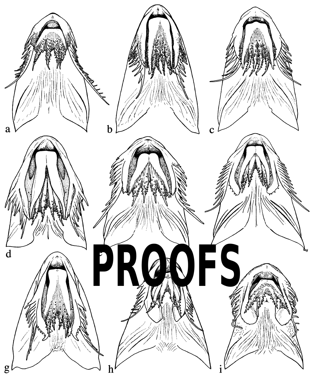
Figs. 4h View Fig and 26 View Fig
Leptodoras juruensis Boulenger 1898: 478 View in CoL (type locality: rio Jurua , Amazonas dr., Brazil).
Diagnosis. Distinguished among Leptodoras by two unique characteristics: body extremely elongate, predorsal distance 26-28% of SL (vs. predorsal distance> 31% in all other Leptodoras ), and dorsal spine thin, weakly ossified, and prolonged well beyond tip of first ray as long flexible filament.
Description. Overall shape relatively unique among doradids. Head and anterior body dorsoventrally depressed, body extremely elongate, becoming cylindrical posteriorly; predorsal distance relatively short (26-28% of SL), ventrally flattened from snout to vent, caudal peduncle long and only slightly more shallow than preceding body. Head triangular in dorsal view with acute snout. Eye rather small with weakly developed adipose eyelid.
Mouth subterminal, jaws edentulous in adults; juveniles less than 70 mm SL usually with few well-formed acicular teeth along distal margin of dentary on either side of medial symphysis. Maxillary barbel comparatively short, usually not reaching ventromedial extent of gill opening. Secondary maxillary barbels 8-11 (modally 9), flattened, overlapping proximally, well separated distally; proximal secondary maxillary barbels with fimbriate anterior margin and smooth posterior margin; distal ones smooth. Oral hood comparatively short overall (i.e., not greatly expanded posteriorly). Upper labial extension thin, curved medially, proximal half straight and narrow, distal half greatly expanded laterally and folded dorsally, appearing confluent with lower labial extension; margin entire (fimbriae absent). Two pairs of jaw barbels with comparatively few scattered elongate papillae; cojoined by basal membrane; outer pair longer than inner pair and shorter than maxillary barbel, cojoined with lower labial extension via narrow membrane. Branchiostegal membrane with narrow fleshy margin weakly overlapping ventral gill opening; fleshy inner flap along cleithrum absent. Morphology of first gill arch similar to L. cataniai .
Sum of midlateral plates 89-91 (modally 90, Table 3). Anterior midlateral plates comparatively shallow, covering about 1/4 of corresponding body depth; posterior margins of dorsal and ventral wings rounded with small serrae. Tympanum usually without distinct ossifications along postotic laterosensory canal; however, small fixed spine usually conspicuous along posterior margin of neurocranium where postotic laterosensory canal exits supracleithrum. Postcleithral process moderately elongate, expanded posteriorly; proximal dorsal margin strongly concave (hemicircular), dorsoposterior margin moderately convex. Middorsal groove on nuchal shield well defined, continuous with middorsal furrow between orbits and anterior groove between nares. Subrectangular nuchal foramina present, replacing suture between epioccipital and anterior nuchal plate. Skin with many small fleshy papillae scattered over snout and dorsal surface of head.
Dorsal-fin rays I,6; pectoral-fin rays I,10; pelvic-fin rays i,6; total anal-fin rays 16-18 (first 5 or 6 unbranched); caudalfin rays i,8/9,i; dorsal procurrent caudal-fin rays 16-18, ventral procurrent caudal-fin rays 14-17. Dorsal-fin spine weakly ossified, very thin, prolonged well beyond tip of first ray as long flexible filament; anterior denticulations antrorse, very small, inconspicuous; posterior denticulations retrorse, weak and inconspicuous, confined to base. Pectoral-fin spine sturdy, short, anterior margin weakly curved, posterior margin straight, tip blunt; anterior denticulations antrorse, moderately sized nearly to tip; posterior denticulations conspicuous, becoming gradually larger and less retrorse towards tip of spine (last and/or penultimate denticulation nearly perpendicular to long axis of spine); last posterior denticulation terminal, its lateral margin continuous with tip of pectoral spine. Pelvic fins comparatively long, bluntly pointed. Anal fin triangular with elongate base; tip of longest branched ray falls well short of vertical through base of last branched ray when fin extended. Caudal fin deeply forked with elongate and pointed lobes.
Coloration in alcohol. Moderately countershaded; dorsal half of snout, head, body (above medial spines of plates) medium to dark gray; undersurfaces and lower sides of head and body (including ventral portion of plates and their median spines) white. Wide dusky middorsal stripe usually evident. Anterior face of cleithrum and dorsoposterior margin of operculum often with dark stippling sometimes forming small irregular blotches. Maxillary barbels usually countershaded, gray above, white below; tip of snout often with narrow dark patch on either side above insertion of maxillary barbel.
Fin coloration somewhat unique among Leptodoras . Adults with variable concentrations of black pigment in dorsal, anal, caudal, and paired fins. Dorsal fin with wide black band along base, dark pigment concentrated on bases of rays and membranes, absent or faint on spine, distal portion of fin depigmented, hyaline. Pectoral fin often intensely black with narrow light distal margin; pigment most concentrated near base of fin, restricted to membranes distally, faint on spine. Pelvic fin with dusky base forming narrow black streaks on membranes, distal margin white.Anal fin sometimes with dusky band on basal half, band widens anteriorly to form dark blotch. Base of caudal fin dusky, interrupted midlaterally by narrow depigmented area. Upper caudal-fin lobe with dusky basal blotch, distal portion white, hyaline. Lower caudal-fin lobe with narrow black steaks formed by concentration of pigment on membranes, dark pigment lacking on rays and along distal margin.
Remarks. The caudal-fin pigmentation in L. juruensis (i.e., lower lobe dusky) is convergent with that of a few North American cypriniform fishes peculiar to deep, swift channels of large rivers. Examples include several minnows in the genera Macrhybopsis and Platygobio (Page & Burr, 1991) and juveniles of the blue sucker, Cycleptus elongatus (Etnier & Starnes, 1993) .
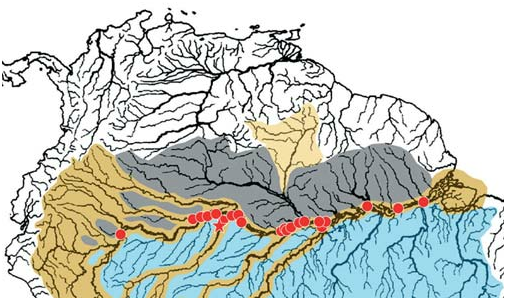
Distribution. Leptodoras juruensis is known from the main channel of the río Amazonas from Iquitos, Peru downriver to near its mouth at the confluence of the rio Xingu, Brazil, and from the lower courses of large Amazonas tributaries (Içá, Juruá, Japurá, Purus, Madeira) ( Fig. 27 View Fig ). This species appears restricted to the deep, rather swift channels of very large whitewater rivers. In the Brazilian Amazon J.G. Lundberg et al. (unpubl. data) collected L. juruensis in bottom trawls at depths ranging from 1 to 50 m. Similar trawling efforts by Lundberg et al. in large blackwater tributaries of the Amazon (e.g., rio Negro) did not yield specimens of L. juruensis . In Peru juveniles were collected by dragging a net with canoes over large sand/silt shoals in the main channels of the río Amazonas where this species is syntopic with L. cf. cataniai and L. myersi .
Type-material examined. Leptodoras juruensis : holotype (unique), BMNH 1898.10 .11.25 (223.0 mm), Brazil, rio Juruá (Amazonas dr.), Jul 1897, J. Bach .
Non-type material. Brazil: Amazonas: ANSP 178682 (1), rio
Solimões (Amazonas dr.), 8.5 km upstream from S. Antônio do Içá (3°10’39"S, 67°55’40"W), 21 Nov 1993 GoogleMaps , JGL-93-103; ANSP 180899 View Materials (1, 288 mm), rio Solimões (Amazonas dr.), 2.8 km downstream of Uara , below mouth of rio Juruá (2°38’21"S, 65°33’9"W), 5 Nov 1993 GoogleMaps , JPF-93-034; ANSP 180930 View Materials (1), rio Solimões ( Amazonas dr.), 14 km upstream from Nova Tonantins (2°58’32.7"S, 67°49’48.5"W), 1993, MG-93-23 GoogleMaps ; FMNH 116135 View Materials (1), rio Japurá (Amazonas dr.), between towns Serraria and Porto Caborira (3°10’34"S, 64°46’11"W), 29 Oct 1993 GoogleMaps , JGL-93-012; FMNH 116136 View Materials (3), rio Jurua (Amazonas dr.), between towns Pauapixuna and Vitória, 9 Nov 1993 , JGL-93- 035; FMNH 116137 View Materials (1), rio Solimões (Amazonas dr.), between towns Foz do Jutaí and Ponta Grossa (2°31’10"S, 66°36’45"W), 12 Nov 1993 GoogleMaps , JGL-93-046; FMNH 116138 View Materials (1), rio Solimões (Amazonas dr.), between towns Siria and Foz do Jutaí (2°40’55"S, 66°53’20"W), 14 Nov 1993 GoogleMaps , JGL-93-056; FMNH 116139 View Materials (6), rio Içá (Amazonas dr.), between towns Betania and São Antônio do Içá (3°8’46"S, 68°2’10"W), 19 Nov 1993 GoogleMaps , JGL-93-089; FMNH 116140 View Materials (1), rio Solimões (Amazonas dr.), between towns Gr. Rural Muiraquita and São Antônio do Içá (3°10’39"S, 67°55’40"W), 21 Nov 1993 GoogleMaps , JGL- 93-103; FMNH 116141 View Materials (2), rio Solimões (Amazonas dr.), between towns Gr. Rural Muiraquita and São Antônio do Içá (3°10’40"S, 67°55’41"W), 21 Nov 1993 GoogleMaps , JGL-93-104; FMNH 116142 View Materials (1), rio Solimões (Amazonas dr.), between towns São Antônio do Içá and Nova Tonantins (3°0’28"S, 67°52’30"W), 23 Nov 1993 GoogleMaps , JGL-93- 121; FMNH 116143 View Materials (1), rio Solimões (Amazonas dr.), between towns São Antônio do Içá and Nova Tonantins (3°0’33"S, 67°52’33"W), 23 Nov 1993 GoogleMaps , JGL-93-122; FMNH 116144 View Materials (2), rio Solimões (Amazonas dr.), between towns Codajás and Anori (3°52’52"S, 61°44’2"W), 29 Nov 1993 GoogleMaps , JGL-93-141; FMNH 116145 View Materials (2), rio Solimões (Amazonas dr.), between towns Codajás and Anori (3°48’49"S, 61°38’26"W), 29 Nov 1993 GoogleMaps , JGL-93-145; FMNH 116146 View Materials (3), rio Solimões (Amazonas dr.), between towns Anori and Porto São Francisco (3°36’10"S, 61°21’19"W), 29 Nov 1993 GoogleMaps , JGL-93-147; FMNH 116147 View Materials (1), rio Solimões (Amazonas dr.), between towns Baronesa and Alvaraes (3°7’11"S, 64°53’18"W), 31 Oct 1993 GoogleMaps , JPF-93-023; FMNH 116148 View Materials (3), rio Solimões (Amazonas dr.), between towns Alvaraes and Pananim (3°11’17"S, 64°48’47"W), 31 Oct 1993 GoogleMaps , JPF- 93-025; FMNH 116149 View Materials (7), rio Solimões (Amazonas dr.), between towns Vitória and Vai-Quem-Quer (2°34’33"S, 65°46’34"W), 5 Nov 1993 GoogleMaps , JPS-93-017; FMNH 116150 View Materials (4), rio Solimões (Amazonas dr.), between towns Tamanicoa and Palheta (2°35’45"S, 65°31’0"W), 5 Nov 1993 GoogleMaps , JPS-93-023; FMNH 116151 View Materials (2), rio Solimões (Amazonas dr.), between towns Gr. Rural Muiraquita and Santo Antônio do Içá (3°9’6"S, 67°54’37"W), 22 Nov 1993 GoogleMaps , JPS-93-075; FMNH 116152 View Materials (18), rio Solimões (Amazonas dr.), between twons Coadi and Alvaraes (3°8’26"S, 64°51’21"W), 30 Oct 1993 GoogleMaps , OTO-93-006; FMNH 116153 View Materials (2), rio Solimões (Amazonas dr.), between towns Tamanicoa and Uara (2°39’2"S, 65°35’5"W), 6 Nov 1993 GoogleMaps , OTO-93-019; FMNH 116154 View Materials (8), rio Solimões (Amazonas dr.), between towns Foz do Jutaí and Fonte Boa (2°31’42"S, 66°36’32"W), 15 Nov 1993 GoogleMaps , OTO- 93-050; FMNH 116157 View Materials (2), rio Amazonas (Atlantic dr.), between towns Novo Oriente and São José do Amatari (3°17’13"S, 58°54’59"W), 13 Oct 1994 GoogleMaps , FL-94-009; FMNH 116158 View Materials (4), rio Amazonas (Atlantic dr.), between towns Santa Antônia and Itacoatiara (3°11’29"S, 58°31’16"W), 18 Oct 1994 GoogleMaps , FL-94-043; FMNH 116163 View Materials (4), rio Amazonas (Atlantic dr.), between towns Novo Oriente and São José do Amatari (3°17’14"S, 58°54’30"W), 14 Oct 1994 GoogleMaps , JGL- 94-026; FMNH 116164 View Materials (1), rio Madeira (Amazonas dr.), between towns Vila Urucurituba and Santa Maria (3°30’31"S, 58°53’38"W), 17 Oct 1994 GoogleMaps , JGL-94-056; FMNH 116171 View Materials (1), rio Purus (Amazonas Dr.), upstream from Solimões (4°3’51"S, 61°33’20"W), 27 Jul 1996 GoogleMaps , AMZ-96-066; FMNH 116172 View Materials (2), rio Solimões (Amazonas dr.), downstream from mouth of rio Purus (3°35’3"S, 61°16’43"W), 28 Jul 1996 GoogleMaps , AMZ-96-088; FMNH 116173 View Materials (4), rio Solimões (Amazonas dr.), upstream from mouth of rio Purus (3°50’45"S, 61°39’27"W), 29 Jul 1996 GoogleMaps , AMZ-96-089; FMNH 116175 View Materials (1), rio Solimões (Amazonas dr.), downstream from mouth of rio Purus (3°35’21"S, 61°5’29"W), 31 Jul 1996 GoogleMaps , AMZ-96-112; FMNH 116176 View Materials (15), rio Amazonas (Atlantic dr.), upstream from town of Itacoatiara (3°20’9"S, 58°36’11"W), 9 Aug 1996 GoogleMaps , AMZ-96-153; FMNH 116177 View Materials (2), rio Amazonas (Atlantic dr.), upstream from town of Itacoatiara (3°21’44"S, 58°39’32"W), 10 Aug 1996 GoogleMaps , AMZ-96-159; FMNH 116178 View Materials (1) rio Solimões (Amazonas dr.), between towns Vila Iranduba and Vila Careiro (3°13’25"S, 59°56’29"W), 20 Jul 1996 GoogleMaps , CCF-96- 026; FMNH 116179 View Materials (1), rio Solimões (Amazonas dr.), between towns Vila Iranduba and Vila Careiro (3°17’30"S, 60°2’26"W), 21 Jul 1996 GoogleMaps , CCF-96-036; FMNH 116180 View Materials (1), rio Solimões (Amazonas dr.), between towns Vila Iranduba and Vila Careiro (3°14’22"S, 59°54’1"W), 21 Jul 1996 GoogleMaps , CCF-96-042; FMNH 116181 View Materials (2), rio Solimões (Amazonas dr.), between towns Vila Iranduba and Vila Careiro (3°16’8"S, 59°55’1"W), 21 Jul 1996 GoogleMaps , CCF-96-044; FMNH 116182 View Materials (4), rio Amazonas (Atlantic dr.), between towns Nova Oriente and Itaquatiara (3°18’25"S, 58°53’19"W), 5 Aug 1996 GoogleMaps , CCF-96-070; FMNH 116183 View Materials (1), rio Amazonas, between towns Nova Oriente and Itaquatiara (3°18’25"S, 58°53’19"W), 5 Aug 1996 GoogleMaps , CCF-96-070; FMNH 116184 View Materials (4), rio Amazonas (Atlantic dr.), between towns Manaus and Itacoatiara (3°20’50"S, 58°38’44"W), 10 Aug 1996 GoogleMaps , CCF-96-106; FMNH 116185 View Materials (3, 1 removed), rio Purus (Amazonas dr.), between towns Surara and Beruri (3°57’28"S, 61°27’41"W), 27 Jul 1996 GoogleMaps , JGL-96-004; FMNH 116186 View Materials (1), rio Amazonas (Atlantic dr.), between towns Santo Antônio and Itacoatiara (3°20’48"S, 58°36’22"W), 30 Jul 1996 GoogleMaps , JGL-96-008; FMNH 116187 View Materials (1), rio Purus (Amazonas dr.), upstream from confluence with Solimões (3°44’12"S, 61°26’29"W), 26 Jul 1996 GoogleMaps , MTP-96-039; FMNH 116188 View Materials (6), rio Solimões (Amazonas dr.), downstream from mouth of rio Purus (3°36’1"S, 61°21’21"W), 28 Jul 1996 GoogleMaps , MTP-96-053; FMNH 116189 View Materials (10), rio Solimões (Amazonas dr.), downstream from mouth of rio Purus (3°36’6"S, 61°20’51"W), 28 Jul 1996 GoogleMaps , MTP-96-054; FMNH 116190 View Materials (1), rio Solimões (Amazonas dr.), upstream from mouth of rio Purus (3°50’12"S, 61°39’22"W), 29 Jul 1996 GoogleMaps , MTP-96-066; FMNH 116191 View Materials (1), rio Solimões (Amazonas dr.), downstream from mouth of rio Purus (3°26’11"S, 60°44’17"W), 31 Jul 1996 GoogleMaps , MTP-96-095; FMNH 116192 View Materials (2), rio Amazonas (Atlantic dr.), upstream from mouth of Madeira (3°15’55"S, 58°57’32"W), 4 Aug 1996 GoogleMaps , MTP-96-104; FMNH 116193 View Materials (3), rio Madeira (Amazonas dr.), downstream from town of Nova Olinda (3°38’26"S, 59°2’45"W), 7 Aug 1996 GoogleMaps , MTP-96-126; FMNH 116194 View Materials (1), rio Amazonas (Atlantic dr.), upstream from town of Itacoatiara (3°20’22"S, 58°36’31"W), 8 Aug 1996 GoogleMaps , MTP- 96-134. Para: FMNH 116155 View Materials (1), rio Amazonas ( Atlantic dr.), between towns Santarém and Monte Alegre (2°25’46"S, 54°25’18"W), 4 Nov 1994 GoogleMaps , AMZ-94-001; FMNH 116156 View Materials (2), rio Amazonas (Atlantic dr.), between towns Monte Alegre and Prainha (2°2’45"S, 53°58’54"W), 5 Nov 1994 GoogleMaps , AMZ-94-035; FMNH 116159 View Materials (3), rio Amazonas (Atlantic dr.), between towns Juruti and Óbidos (1°59’23"S, 55°47’50"W), 22 Oct 1994 GoogleMaps , FL-94-060; FMNH 116160 View Materials (5), rio Amazonas (Atlantic dr.), between towns Óbidos and Santarém (2°3’41"S, 55°21’45"W), 27 Oct 1994 GoogleMaps , FL-94-095; FMNH 116161 View Materials (6), rio Amazonas (Atlantic dr.), between towns Óbidos and Santarém (2°4’39"S, 55°20’53"W), 27 Oct 1994 GoogleMaps , FL- 94-097; FMNH 116165 View Materials (11), rio Amazonas (Atlantic dr.), between towns Óbidos and Santarém (1°59’59"S, 55°25’46"W), 27 Oct 1994 GoogleMaps , JGL-94-081; FMNH 116166 View Materials (2), rio Amazonas (Atlantic dr.), between towns Santarém and Monte Alegre (2°6’17"S, 54°0’53"W), 5 Nov 1994 GoogleMaps , JGL-94-092; FMNH 116167 View Materials (1), rio Amazonas (Atlantic dr.), between towns Santarém and Monte Alegre (2°4’52"S, 53°59’55"W), 4 Nov 1994 GoogleMaps , LRP-94-011; FMNH 116169 View Materials (1), rio Amazonas (Atlantic dr.), between towns Almeirim and Gurupa (1°27’45"S, 52°5’36"W), 11 Nov 1994 GoogleMaps , LRP-94-052; FMNH 116170 View Materials (2), rio Amazonas (Atlantic dr.), between towns Almeirim and Gurupa (1°29’51"S, 51°50’30"W), 14 Nov 1994 GoogleMaps , LRP-94-060. Peru: Loreto: ANSP 112321 View Materials (1, 125.23 mm), ANSP 112322 View Materials (5, 70.3-93.26 mm), río Amazonas (Atlantic dr.), vicinity of Iquitos, between Isla Iquitos and Isla Lapuna, near I. Lapuna shore, 9 Oct 1955 , P55-9; INHS 39465 View Materials (2, 94.5, 117.4 mm), río Amazonas (Atlantic Dr.), playa Cañaves, 20 minutes south of Gallito by boat, 21 Aug 1996 ; SIUC 29522 View Materials (1, 127.0 mm) río Momon (Amazonas dr.), near Iquitos, Jul 1995 .

No known copyright restrictions apply. See Agosti, D., Egloff, W., 2009. Taxonomic information exchange and copyright: the Plazi approach. BMC Research Notes 2009, 2:53 for further explanation.
|
Kingdom |
|
|
Phylum |
|
|
Class |
|
|
Order |
|
|
Family |
|
|
Genus |
Leptodoras juruensis Boulenger, 1898
| Sabaj, Mark Henry 2005 |
Leptodoras juruensis
| Boulenger, G 1898: 478 |