
Miconia sessilis Gamba & Almeda, 2014
|
publication ID |
https://doi.org/ 10.11646/phytotaxa.179.1.1 |
|
DOI |
https://doi.org/10.5281/zenodo.5156371 |
|
persistent identifier |
https://treatment.plazi.org/id/03C887CB-FB2E-FF07-FACB-EFF9FBB25E08 |
|
treatment provided by |
Felipe |
|
scientific name |
Miconia sessilis Gamba & Almeda |
| status |
nom. nov. |
30. Miconia sessilis Gamba & Almeda View in CoL , nom. nov. Basionym: Oxymeris sessilifolia Triana (1871: 93) . Leandra sessilifolia (Triana) Cogniaux (1886b: 75) . Ossaea sessilifolia (Triana) Wurdack (1973a: 407) . Type: COLOMBIA.
SYSTEMATICS OF THE OCTOPLEURA CLADE OF MICONIA
Phytotaxa 179 (1) © 2014 Magnolia Press 127
Nariño (Prov. Barbacoas), versus littus maris Pacifici , May 1853, Triana 4075 (holotype: BM-internet image!; isotype: COL-internet image!). Nec Miconia sessilifolia Naudin (1850: 181) .
Ossaea grandifolia Gleason (1925: 457) View in CoL . Type: COLOMBIA. Dept. Valle: Cordoba, Dagua valley , 80–100 m, 6 May 1922, Killip 5120 (holotype: NY-internet image!; isotype: PH-internet image!).
Shrub or little-branched small tree 1.5–5 m tall. Upper internodes compressed-rounded (1.3–) 6.7–12.9 cm long, cauline nodes terete, nodal line absent but each node with a pair of conspicuous short appendages under the petioles. Indumentum on branchlets, petioles, adaxial surface and primary vein of young leaves, abaxial surface, primary and secondary leaf veins, inflorescence axes, bracts, bracteoles, pedicels, hypanthia, calyx lobes, calyx teeth, and petals abaxially copiously to moderately and caducously covered with brownish-translucent dendritic trichomes 0.05–0.08 mm long with short axes and few-moderate number of terete arms. Leaves of each pair isophyllous; petiole 0.3–0.7 cm long, adaxially canaliculate, abaxially shallowly grooved; blades 17.5–38 × 6.7–17.7 cm, elliptic-oblong to elliptic-ovate, the base acute to attenuate and conspicuously decurrent on the petiole, the margin obscurely denticulate, the apex short-acuminate to acuminate, chartaceous; mature leaves adaxially (including primary and secondary veins) glabrescent, the tertiary and higher order veins glabrous; abaxial surface yellowish-green, occasionally flushed purple, soon glabrous, the tertiary and higher order veins glabrous; 5-plinerved, including the tenuous marginals, innermost pair of secondary veins diverging asymmetrically from the primary vein 3–5 cm above the base, areolae 4–5 mm, adaxially the primary and secondary veins slightly impressed, the tertiary and higher order veins flat, abaxially the primary and secondary veins elevated, canaliculate to terete, the tertiary and higher order veins slightly elevated to flat. Inflorescences an erect pseudolateral multiflorous dithyrsoid 13–27 cm long, including a rounded-quadrate peduncle 3.6–7 cm long, laxly and divaricately branched from the peduncle apex, the rachis green-yellowish to pink-purple; bracts and bracteoles 0.8–1 × 0.35–0.5 mm, subulate and concave, the bracts spreading, the bracteoles somewhat erect, subpersistent at anthesis. Flowers 4-merous sessile to subsessile, pedicels less than 0.2 mm long when present. Hypanthia at anthesis 1.5–1.9 × 1.6 mm, free portion of hypanthium 0.7–0.9 mm long, campanulate to subglobose, bluntly 8-ribbed, green-yellowish to red-purplish, ridged on the inner surface, glabrous, the torus adaxially sparsely resinous-glandular. Calyx open in bud and persistent in fruit, light pink-purplish; tube (0.1–) 0.2–0.5 mm long, glabrous adaxially and with the same vestiture as the hypanthium abaxially; lobes 1.1–1.3 × 1.5 mm, broadly triangular and somewhat spreading, the margin obscurely undulate, the apex bluntly acute; exterior calyx teeth 0.2–0.3 mm long, tuberculiform, inserted half way up the calyx lobes and not projecting beyond them. Petals 1.8–2 × 1 mm, lanceolate, the margin entire, the apex bluntly acute, whitish to pale pink, glabrous adaxially, the abaxial indumentum more abundant toward the apex, reflexed at anthesis. Stamens 8; filaments 1–1.1 × 0.25 mm, white, yellowish, glabrous; anther thecae 1.6–1.7 × 0.5 mm, oblong-obovate, emarginate at the apex, opening by two dorsally inclined pores 0.15 mm in diameter, yellowish; connective yellowish, its prolongation and appendage 0.6–0.7 mm long, the appendage subulate-triangular, bluntly acute at the apex, copiously gland-edged throughout the connective and on both sides of its prolongation and appendage, the glands with linear to subulate stalks. Ovary 4-locular, completely inferior, 0.9–1.1 mm long at anthesis, the apical collar 0.2–0.3 × 0.4 mm, conic, sparsely glandular-puberulent to glabrous; style 4–4.2 mm long at anthesis, parallel-sided (i.e. terete), white to cream, glabrous; stigma expanded truncate. Berries 4–7 × 4 mm when dry, globose-oblate, at first green, then turning green-yellow to orange and ultimately ripening red-orange, the hypanthium indumentum persistent at maturity. Seeds 0.4–0.43 × 0.19–0.21 mm, ovoid, angled, brownish; lateral and antiraphal symmetrical planes ovate, the highest point toward the chalazal side; raphal zone suboblong, ca. 90% to nearly as long as the seed, somewhat ventrally expanded toward the micropyle; individual cells elongate, anticlinal boundaries (some channeled, others raised), undulate, with Ω- and U-type patterns; periclinal walls convex, low-domed, microrelief verrucose.
Additional specimens studied:— COLOMBIA. Cauca: ( Guapi ), P.N.N. Isla Gorgona, 30 May 1986, Lozano & Rangel 5044 ( CAS, COL); (Guapi) , P.N.N. Isla Gorgona, Camino a Pablo VI y cabo Hornos , 30–50 m, 4 June 1986, Lozano & Rangel 5256 ( COL, US); (Guapi) , P.N.N. Gorgona, Alto de Los Micos , 8 September 1987, Lozano & Rangel 5699 ( COL, MO) ; Río Naya near El Pastico , 3.1°N, 77.22°W, 20–100 m, 23 February 1983, Gentry & Juncosa 40607 ( MO, US) GoogleMaps ; Gorgona Island, Eside of Gorgona Island , 50–100 m, 11 February 1939, Killip & García 33186 ( US) . Chocó: (Nuquí), Alto de Buey , 1000 m, 8 June 1940, von Sneidern A.41 ( US); (Istmina) , Alto Río San Juan, estribaciones de los Cerros La Mojarra , 100–120 m, 26 June 1983, Espina et al. 1386 ( CHOCO, MO, US) ; Banks of Quebrada Togoromá , 13 June 1944, Killip & Cuatrecasas 39147 ( US); (Cabo Corrientes) , Río
128 Phytotaxa 179 (1) © 2014 Magnolia Press
GAMBA & ALMEDA
Parguera, at foot of Janano mountain , 50–100 m, 27 May 1974, Warner 300 (F, MO) ; Serranía del Baudó , Along road between Las Animas and Río Pato, along valley of Río Animas, 5 km from beginning of road, 5°16’N, 76°41’W, 100 m, 17 April 1983, Croat 56042 ( MO) GoogleMaps ; Serranía del Baudó , Along road between Las Animas and Río Pato, along valley of Río Animas, 5 km from beginning of road, 5°16’N, 76°41’W, 100 m, 17 April 1983, Croat 56047 ( US); (Quibdó) GoogleMaps Pacurita, Corporación Michitá, Estación Ambiental Pandó, Sendero Ecológico, 5.69°N, - 71.61°W, 90 m, 25 January 2012, Almedaet al. 10390 ( CAS, CHOCO, COL) GoogleMaps . Nariño: (Barbacoas), El Diviso, A 27 km del Diviso, quebrada La Angosta margen izquierdo de la carretera via Diviso-Tumaco, 650 m, March 1995, Fernández 12500 ( COL, US) . Putumayo: (Mocoa), San Antonio, Alto Campucana, Finca la Mariposa , Vertiente amazónica de Colombia, 1°12’N, 76°38’W, 1350–1420 m, 20 April 1994, Fernández et al. 11038 ( COL, NY) GoogleMaps .
Valle: (Buenaventura), Bajo Calima, Concesión Pulpapel , Carretera a Juanchaco 6 km de la portada, 3°55’N, 77°W, 100 m, 23 August 1986, Monsalve 1071 ( CAS, CUVC, MO); ( Buenaventura ) GoogleMaps , Bajo Calima, alongroad between Buenaventura and Malaga, at km 51.3, deep gorge, 4°9’N, 77°11’W, <100 m, 27 February 1990, Croat 71021 ( CAS, MO); ( Buenaventura ) GoogleMaps , Bajo Calima, Concesión Pulpapel , 3°55’N, 77°, 100 m, 23 August 1984, Monsalve 228 ( CAS, CUVC, MO) ; Río Calima, Quebrada de La Brea , 30–40 m, 19 May 1946, Schultes & Villareal 7352 ( US) ; Costa del Pacífico, Río Yurumanguí , Veneral, 5–50 m, 28 January 1944, Cuatrecasas 15711 (F, US) ; Puerto Merizalde, Costa del Pacífico, Río Naya , 5–20 m, 20 February 1943, Cuatrecasas 13984 (F); (Córdoba) , 50–100 m, 17 February 1939, Killip & García 33429 ( NY) ; La Trojita, Río Calima (región del Chocó), 5–50 m, 19 February 1944, Cuatrecasas 16540 (F, NY) ; Silva, Costa del Pacífico, Río Cajambre, 5–80 m, 5 May 1944, Cuatrecasas 17420 (F, NY); ( Buenaventura ) , Bajo Calima Region, Along road between Buenaventura and Malaga, at km 31.5, 4°1’N, 77°5’W, <100 m, 6 February 1990, Croat & Watt 70277 ( MO); ( Buenaventura ) GoogleMaps , Bajo Calima Region, Concesión Pulpapel / Buenaventura, 100 m, 11 March 1986, Monsalve 957 ( MO); ( Buenaventura ) , Bajo Calima Region, within Forestry Concession of Cartón de Colombia, between Buenaventura and Río Calima , 6.3 km Nof Frente La Brea, km 18 on main road, about 6 km SE of village of San Isidro on Río Calima , 4°2’N, 77°3’W, 50 m, 7 July 1986, Croat 61307 ( MO) GoogleMaps ; Bajo Calima Region, Road to Juanchaco Palmeras , 3°55’N, 77°2’W, 100 m, 10 July 1984, Gentry et al. 47817 ( MO); ( Buenaventura ) GoogleMaps , Bajo Calima Region, Concesión Pulpapel, Carretera a San Isidro , 3°55’N, 77°W, 100 m, 30 September 1987, Monsalve 1860 ( MO); ( Buenaventura ) GoogleMaps , Bajo Calima Region, ca 10 km due Nof Buenaventura, carton de Colombia Concession, 3°56’N, 77°8’W, 50 m, 5 December 1981, Gentry 35348 ( MO); ( Buenaventura ) GoogleMaps , Bajo Calima Region, Vicinity of Buenaventura, along road from Buenaventura to Málaga , km 11 at Pulpapel headquarters, 3°56’N, 77°0’W, 130 m, 10 July 1993, Croat & Bay 75610 ( MO); ( Buenaventura ) GoogleMaps , Bajo Calima Region, within forestry Concession of Cartón de Colombia, between Buenaventura and Río Calima, 6.5 km beyond Porton tomar (at km 27), 22.3 km beyond Camp Portada Pulpapel , 33.3 km beyond main Cali-Buenaventura Hwy , 4°2’N, 77°7’W, 50 m, 8 July 1986, Croat 61367 ( MO, US); ( Buenaventura ) GoogleMaps , Bajo Calima Region, Road to Juanchaco Palmeras , 3°55’N, 77°2’W, 100 m, 10 July 1984, Gentry et al. 47824 ( MO); ( Buenaventura ) GoogleMaps , Bajo Calima Region, Conseción Pulpapel / Buenaventura , Carretera La Gasolina PD12, 3°55’N, 77°’W, 100 m, 1 September 1987, Monsalve 1692 ( MO); ( Buenaventura ) , Bajo Calima Region, Carton de Colombia lumber concession area, Carretera Gasolina 6 km Sof main road between Cali-Buenaventura hwy and Canalete , 1 km Wof Carretera Gasolina, 3°56’0"N, 77°7’30"W, 50–80 m, 19 July 1988, Croat 69392 ( MO); ( Buenaventura ) GoogleMaps , Bajo Calima Region, Granja Agroforestal, 40 m, 14 December 1984, Devia 461 ( MO, TULV); ( Buenaventura ) , Bajo Calima Region, Concesión Pulpapel / Buenaventura , 3°55’N, 77°W, 100 m, 31 August 1984, Monsalve 321 ( CUVC, MO); ( Buenaventura ) GoogleMaps , Bajo Calima Region, Dindo area, 3°59’N, 76°58’W, 100 m, 20 July 1984, Gentry & Monsalve 48401 ( MO, US); ( Buenaventura ) GoogleMaps , San Isidro, Quebrada Ordoñez, 40 m, 6 March 1989, Devia & Prado 2670 ( TULV, US) . ECUADOR. Esmeraldas: (San Lorenzo), R. Indígena Awá, Cañón del Río Mira , 10 km al Wde Alto Tambo, Comunidad "La Union", 1°2’N, 78°26’W, 250 m, 16 March 1997, Rubio et al. 1239 ( MO, QCNE, US) GoogleMaps .
Illustration:— None found.
Common names and documented uses:— None recorded.
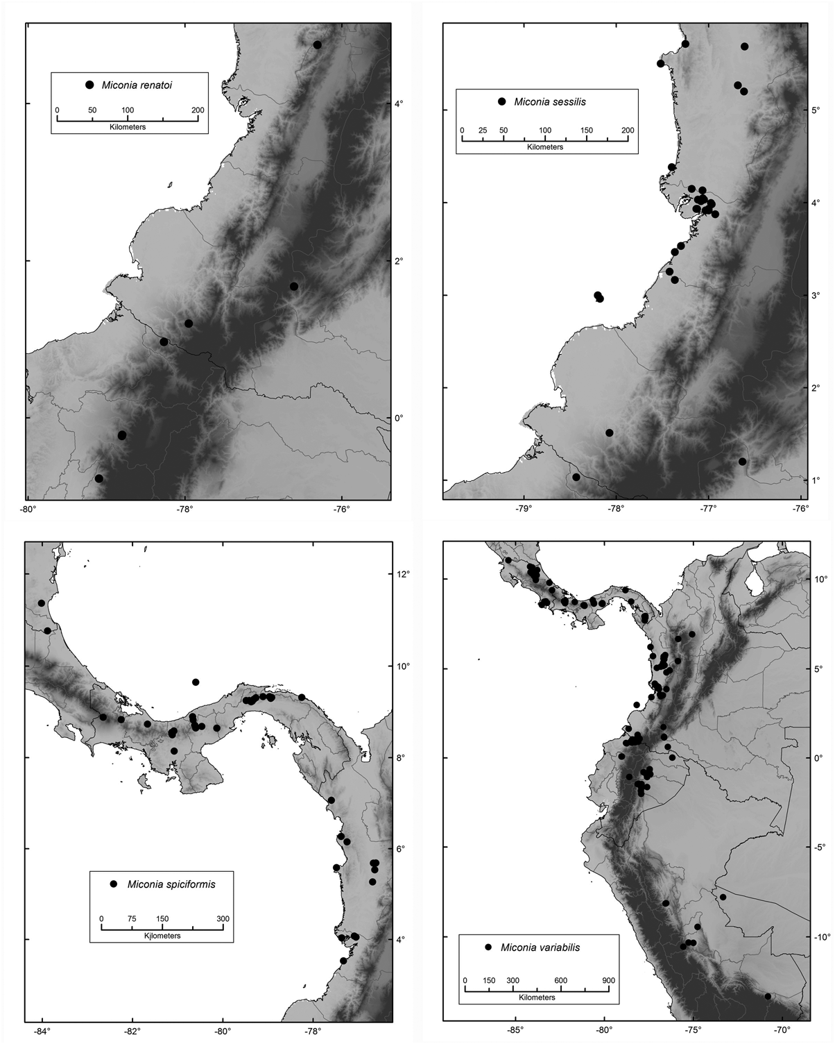
Habitat, distribution and ecology:— This is a locally common to infrequent species in primary and secondary rainforests and disturbed sites, growing along streams, on steep slopes or at forest margins, in the lowlands of the Biogeographic Chocó in Colombia, and with one record from Esmeraldas ( Ecuador) ( Fig. 17 View FIGURE 17 ), at 5–1000 (1420) m, but more common between 5–250 m. In Colombia it has been most commonly collected in the Bajo Calima area ( Valle ), with populations in the departments of Chocó and Cauca (Isla Gorgona ) .
Phenology:— Collected in flower and fruit from December through September.
SYSTEMATICS OF THE OCTOPLEURA CLADE OF MICONIA
Phytotaxa 179 (1) © 2014 Magnolia Press 129
Etymology:— The specific epithet refers to the distinctive sessile leaves of this species.
Discussion:— This species is distinct in its leaf blades that are long decurrent on the petioles, striking asymmetrical plinervation, 4-merous flowers, and petals that are puberulent-dendritic abaxially. Miconia laxivenula , its sister species, has similar lax abaxial foliar reticulation, leaf bases somewhat decurrent on the petiole, and 4-merous flowers. The latter differs primarily in its vegetative vestiture (squamate-amorphous). Moreover, M. sessilis has a distinctly lobed calyx (broadly triangular vs. depressed-rounded) and smaller petals. Also close is M. variabilis , which differs in the much denser tertiary/intertertiary reticulation (areoles ca. 0.2 mm wide), much denser cauline and inflorescence pubescence, and 5-merous flowers.
Conservation status:— This species would be considered Endangered EN B2ab(iii) following IUCN criteria (AOO). However, a status of Vulnerable VU is warranted because it occurs in some protected areas within its range. Protected in Colombia in the Isla Gorgona National Park (Cauca), and in the Pandó Environmental Station (Chocó). In Ecuador it is protected in the Awá Indigenous Reserve (Esmeradas).
| CAS |
California Academy of Sciences |
| COL |
Universidad Nacional de Colombia |
| US |
University of Stellenbosch |
| MO |
Missouri Botanical Garden |
| CHOCO |
Universidad Tecnológica del Chocó |
| NY |
William and Lynda Steere Herbarium of the New York Botanical Garden |
| CUVC |
Universidad del Valle |
| TULV |
Jardín Botánico Juan Maria Cespedes |
| QCNE |
Museo Ecuatoriano de Ciencias Naturales |
No known copyright restrictions apply. See Agosti, D., Egloff, W., 2009. Taxonomic information exchange and copyright: the Plazi approach. BMC Research Notes 2009, 2:53 for further explanation.
|
Kingdom |
|
|
Phylum |
|
|
Class |
|
|
Order |
|
|
Family |
|
|
Genus |
Miconia sessilis Gamba & Almeda
| Gamba, Diana & Almeda, Frank 2014 |
Ossaea grandifolia
| Gleason, H. A. 1925: ) |