
Neduba carinata Walker, 1869
|
publication ID |
https://doi.org/ 10.11646/zootaxa.4910.1.1 |
|
publication LSID |
lsid:zoobank.org:pub:69A0204C-15B4-4566-AA27-E3817087130A |
|
DOI |
https://doi.org/10.5281/zenodo.4465015 |
|
persistent identifier |
https://treatment.plazi.org/id/039C87AE-7D6F-FFDC-FF47-07CF71CDF915 |
|
treatment provided by |
Plazi |
|
scientific name |
Neduba carinata Walker, 1869 |
| status |
|
Neduba carinata Walker, 1869 View in CoL
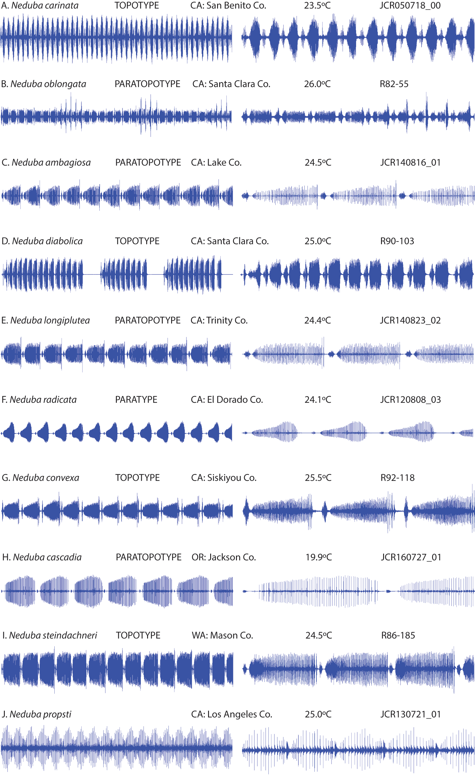
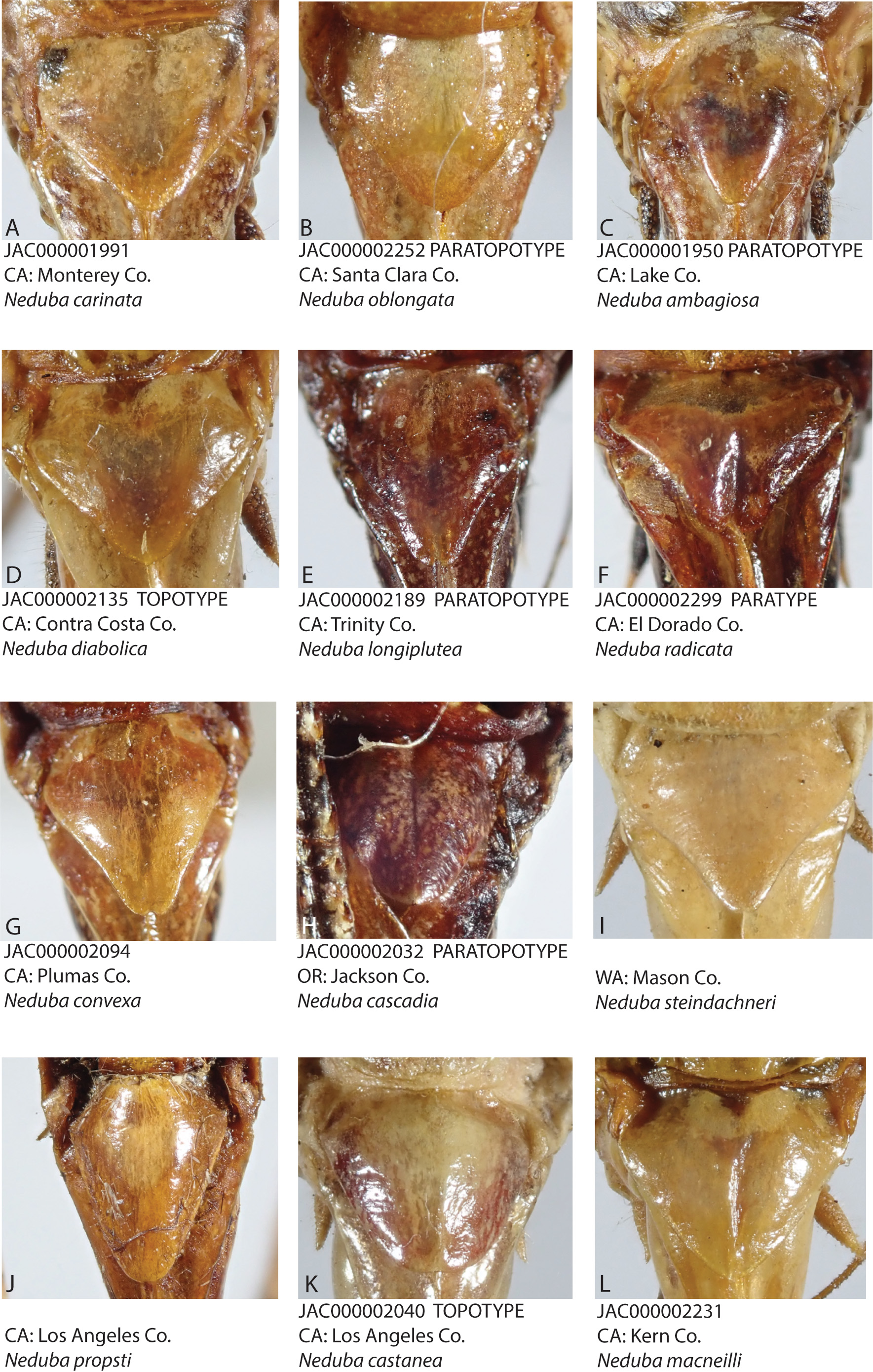
Figure 9 View FIGURE 9 (distribution), Fig. 10 View FIGURE 10 (male and female habitus, calling song, male and female terminalia, karyotype), Plate 1A View PLATE 1 (live habitus), Plate 4A View PLATE 4 (male calling song), Plate 6 View PLATE 6 A–D (ventral sclerites), Plate 9 View PLATE 9 A–C (male titillators), Plate 11A View PLATE 11 (female subgenital plate).
Common name. Carinate Shieldback.
History of recognition. As the type species of Neduba , establishing the identity of N. carinata is of central taxonomic importance. In a situation resembling that of Gryllus assimilis ( Rehn & Hebard 1915) , N. carinata was at times used as a “trash can” taxon ( Rentz & Birchim 1968), into which multiple species were binned (e.g. Tinkham 1944). The broad type locality of “ California ” was narrowed to Fremont Peak, San Benito County, California, USA ( Rentz & Birchim 1968). We accepted this type locality designation and determined taxonomic and geographic relationships relative to this locality. The Fremont Peak type locality is in the Gabilan Range of the South Coast Ranges of California. In over 40 years of fieldwork by orthopterists at Fremont Peak (e.g. Helfer 1987; Rentz & Birchim 1968; Strohecker et al. 1968), sympatric Neduba species have not been found at this locality; however, the correct assignment of the name N. carinata requires that all other possibilities are eliminated. This is a valid concern considering that an additional Neduba species occurs in the South Coast Ranges (see N. lucubrata ). Images of the N. carinata holotype show a subgenital plate with parallel lateral carinae and long, articulate styli ( Cigliano et al. 2020), a condition that is found in all topotypic males that we have examined. In contrast, the subgenital plate of N. lucubrata has lateral carinae that converge to the apex and terminate in rudimentary knob-like styli. Thus, we conclude that the name N. carinata indeed belongs to our topotypic series. Variety picturata ( Scudder 1899) was synonymized under N. diabolica ( Rentz & Birchim 1968) .
Type material. F. Walker’s male holotype of N. carinata resides in the British Museum. Type not examined by us but images available at OSFO ( Cigliano et al. 2020) . TOPOTYPES EXAMINED (n = 25) : USA, CA , San Benito Co., 2♁, Fremont Peak State Park , peak area, 36.760793N, 121.502442W, 457 m, 25-VI-1982, DB Weissman, CAS GoogleMaps ; 6♁, 1♀, same data except 762 m, 25-VI-1982, DB Weissman, CAS GoogleMaps ; 14♁, 1♀, Fremont Peak State Park , Valley View Campground, 11 mi. S of San Juan Bautista on County Road G1, 36.7597N, 121.505W, 829 m, 18–19- VII-2005, JA Cole, JF Eguizabal, LACM GoogleMaps ; 1♁, same data except JAC GoogleMaps .
Measurements. (mm, ♁n = 34, ♀ n = 7) Hind femur ♁18.33–28.80, ♀ 21.55–26.21, pronotum total length ♁8.23–10.72, ♀ 8.35–10.05, prozona length ♁3.43–4.88, ♀ 4.02–5.20, metazona dorsal length ♁4.45–6.45, ♀ 3.67– 4.85, pronotum constriction width ♁2.00–2.78, ♀ 2.35–3.00, metazona dorsal width ♁5.11–7.25, ♀ 5.18–6.45, head width ♁3.89–4.84, ♀ 4.60–5.32, ovipositor length ♀ 16.00–18.27.
Distribution. South Coast Ranges of California, from the southern San Francisco Bay Area south along the Santa Lucia Range to Morro Bay.
Habitat. Understory vegetation, tangles, and leaf litter in mixed woodland, riparian woodland, and coastal redwood ( Sequoia sempervirens (Lamb. ex D. Don) Endl. ) forest. Males call near the forest floor from plants such as poison oak ( Toxicodendron diversilobum (Torr. & A. Gray)) , introduced Mediterranean grasses, and peavines ( Lathyrus sp.).
Seasonal occurrence. Adults from late June (23-VI-1957, TJ Cohn, CAS) through December (18-XII-2016, DW Weissman, CAS). Nymphs collected in May and alongside adults in late June (CAS).
Stridulatory file. (n = 24) length 2.4–3.4 mm, 115–159 teeth, tooth density 44.7 ± 3.9 (38.5–55.3) teeth/mm.
Song. (n = 52) Frequent sustained bouts of low frequency lisping. Males call incessantly at night and sometimes during the afternoon. PTR 10.9 ± 2.1 s- 1. The MPT and OPT are subequal in length. Males spend a lot of time singing with PTdc 73.1 ± 9.7% (calculated by combining both MPT and OPT) . PTF 11.4 ± 1.7 kHz is among the lowest carrier frequencies in the genus.
Karyotype. (n = 22) 2n♁ = 26 (2m + 22t + XtYt). T82-6, S82-26, topotype.
Recognition. This species is separated morphologically from all other species in the Carinata Group except N. diabolica by the high stridulatory file tooth density (38–55 teeth/mm). The male ventral sclerite throughout most of the range has the shaft broad and straight (narrow, curved shaft in Convexa Clade), the apex broad and convex to subconical covered with tubercles of large size, and a short lateral process (often long and shelf-like in the Convexa Clade). In N. carinata populations found near the Convexa Clade in the South Bay Area, the ventral sclerite of the former species resembles the latter and is an unreliable diagnostic feature; songs remain diagnostic. Acoustically, the low frequency, rasping or lisping bouts of song with a fast uniform PTR (~11 s-1) separate this species from all other Neduba except N. diabolica . Females have a pentagonal subgenital plate without sinuous distal margins and no medial groove, characters shared only with N. oblongata .
Notes. This is a common species in California Coast Range woodlands throughout summer and fall. The proximity of the range to the heavily populated San Francisco Bay Area and the low frequency calling song that many people can hear makes this one of the most commonly encountered species. Considerable variation exists in the male internal genitalia, which we attribute to historical episodes of population isolation and contact as the California coastline and Coast Ranges changed repeatedly and dramatically over the Cenozoic Era. The Santa Lucia Range and portions of the Santa Cruz Mountains have changed between islands, peninsulas, and broad mainland connections ( Bartow 1991). A distinct ventral sclerite shape is found in the Santa Lucia Range ( Fig. 10 View FIGURE 10 , Plate 6B View PLATE 6 ), which may reflect separation from the Coast Ranges north of Monterey Bay by a marine embayment that lasted from 18 to 2 Ma ( Hall 2002). Santa Cruz Mountains N. carinata have ventral sclerites with long lateral processes ( Fig. 10 View FIGURE 10 , Plate 6D View PLATE 6 ) that resemble those of several Convexa Clade taxa ( Plates 6–7 View PLATE 6 View PLATE 7 ). The Carinata and Convexa Clades meet geographically in the San Francisco Bay Area, where mtDNA introgression ( Fig. 4 View FIGURE 4 ) suggests gene flow as the explanation for shared ventral sclerite morphology despite distinct calling song differences.
Material examined (n = 116). All USA, CA, Monterey Co., 1♁, 1.5 mi. N of Carmel , 36.58N, 121.92W, 213 m, 23-VI-1957, TJ Cohn GoogleMaps , CAS; 1♁, 1♀, 11.2 mi. N Pfeiffer Big Sur State Park off Hwy 1, 36.411288N, 121.782732W, 5-VII-1986, DB & BI Weissman GoogleMaps , CAS; 1♀, Asilomar , 1.3 mi. W of Pacific Grove, 36.617735N, 121.94011W, 10-VII-1957, TJ Cohn GoogleMaps , CAS; 1♀ nymph, Big Sur River Trail , 36.280942N, 121.860028W, 21–23- V-1971, FS Bartholomew GoogleMaps , CAS; 6♁, 1♀, Big Sur , SR1, 36.3547N, 121.8136W, 685 m, 20-VIII-2012, JA Cole GoogleMaps , LACM; 2♁, Bottcher’s Gap, Los Padres National Forest, 19 miles north of Big Sur off SR1 on Palo Colorado Road , 36.355N, 121.8138W, 652 m, 20-VIII-2012, JA Cole GoogleMaps , LACM; 2♁, same data except 7-IX-2002, JA Cole GoogleMaps , LACM; 1♁, 1♀, same data except GoogleMaps JAC; 1♁, Nacimiento-Ferguson Rd. , at bridge of Nacimiento R., 8.4 mi. E of SR1, 36.0135N, 121.4216W, 587 m, 19–20-VIII-2012, JA Cole GoogleMaps , JAC sound record; 2♁, 1♀, Pacific Grove , 36.617738N, 121.916622W, 4-VII-1925, HH Keifer GoogleMaps , CAS; 1♁, Palo Colorado Rd. , 3 mi. E of SR1, 36.3864N, 121.8687W, 327 m, 20-VIII-2012, JA Cole GoogleMaps , JAC sound record; 1♁ nymph, Pebble Beach , 36.56635N, 121.946622W, 18-V-1969, RP Allen GoogleMaps , CSCA; 1♀ nymph, same data except 27-V-1921, EC VanDyke GoogleMaps , CAS; 1♁, Pfeiffer Big Sur State Park , 36.248852N, 121.782732W, 60 m, 23-IX-1995, DB Weissman GoogleMaps , CAS; 3♁, same data except 27-IX-1985, DB Weissman GoogleMaps , CAS; 4♁, 3♀, same data except 5-VII-1986, DB & BI Weissman GoogleMaps , CAS; San Benito Co., see Type material above ; San Francisco Co., 1♁, San Francisco , 37.77493N, 122.419416W, 24-X-1909, FX Williams GoogleMaps , CAS; San Mateo Co., 2♁, Jasper Ridge , 37.407995N, 122.22691W, 12-VII-1982, DB Weissman GoogleMaps , CAS; 1♁, Kings Mount , 37.44083N, 122.32333W, 14-X-1946, ES Ross GoogleMaps , CAS; 1♁, 1♀, same data except 17-VIII-1946, ES Ross GoogleMaps , CAS; 1♁, Portola State Park , 37.2527N, 122.21854W, 8-VIII-1962, RP Allen GoogleMaps , CSCA; Santa Clara Co., 1♀, Los Gatos , 12-XII-1965, J Harville , CAS; 2♁, Los Gatos, 15431 Francis Oaks Way , 37.22661N, 121.97468W, 22-VIII-2013, DB Weissman GoogleMaps , CAS; 1♁, same data except VI-1986, DB Weissman GoogleMaps , CAS; 7♁, 2♀, Los Gatos, Francis Oaks Way , 37.226611N, 121.97468W, 120 m, 6-VII-1987, DB Weissman GoogleMaps , CAS; 2♁, Uvas Canyon County Park, 15 miles west of Morgan Hill on Croy Road , 37.0855N, 121.7954W, 349 m, 19-20-VII-2005, JA Cole, JF Eguizabal GoogleMaps , JAC; 6♁, 1♀, same data except GoogleMaps LACM; 1♁, 2♀, same data except 2-3-VII-2003, JA Cole GoogleMaps , LACM; 2♁, 2♀, same data except 22-VIII-2014, DB & DW Weissman GoogleMaps , CAS; 1♁, same data except 6-IX-2002, JA Cole GoogleMaps , JAC; 2♁, same data except GoogleMaps LACM; 1♁, Mount Umunhum , 37.15255N, 121.89897W, 1008 m, 5-VII-2018, DW & DB Weissman GoogleMaps , CAS; Santa Cruz Co., 1♀, Loma Prieta , 37.110781N, 121.844676W, 2-VIII-1959 GoogleMaps , CAS; 1♀, Santa Cruz , 36.974117N, 122.030796W, 25-XI-1955, RL Lewis GoogleMaps , CSCA; 1♁, Soquel , 36.98801N, 121.95663W, 18-XII-2016, DW Weissman GoogleMaps , CAS; 4♁, same data except 9-IX-2014, DW Weissman GoogleMaps , CAS; 1♁, Summit above Saratoga , 37.263832N, 122.023015W, 26-VIII-1968, J Smith GoogleMaps , BMED; 6♁, 1♀, U.C. Santa Cruz Campus , 36.974117N, 122.030796W, 25- VI-1982, SI Weissman GoogleMaps , CAS.


No known copyright restrictions apply. See Agosti, D., Egloff, W., 2009. Taxonomic information exchange and copyright: the Plazi approach. BMC Research Notes 2009, 2:53 for further explanation.
|
Kingdom |
|
|
Phylum |
|
|
Class |
|
|
Order |
|
|
Family |
|
|
Genus |