
Oaphantes cryophilus, Paquin & Dupérré & Buckle & Ubick, 2020
|
publication ID |
https://doi.org/ 10.11646/zootaxa.4819.2.7 |
|
publication LSID |
lsid:zoobank.org:pub:CD947034-6503-4F6E-B496-4FF18DEC7AD0 |
|
DOI |
https://doi.org/10.5281/zenodo.4396987 |
|
persistent identifier |
https://treatment.plazi.org/id/EC81F6F6-BE6B-4A1A-A04C-3AACC870DEFF |
|
taxon LSID |
lsid:zoobank.org:act:EC81F6F6-BE6B-4A1A-A04C-3AACC870DEFF |
|
treatment provided by |
Plazi |
|
scientific name |
Oaphantes cryophilus |
| status |
sp. nov. |
Oaphantes cryophilus View in CoL new species
( Figs 9–16 View FIGURES 9–16 , 25 View FIGURE 25 , 27)
Oaphantes View in CoL sp. 2: Paquin et al. 2009a: 51–53, Elliott et al., 2017: 181.
Type material.— HOLOTYPE: USA: California: Tulare Co., Sequoia National Park, Bear Den Cave , 03.xi.2004, in cave 1450m, hand collecting, 1♂, D. Ubick, P. Paquin, S. Fryer (deposited at CAS 9078641).
PARATYPES: CANADA: British Columbia: Mount Cain, Vancouver Island [50°14’N, 126°20’W] 28.ix.1996, pan trap, 1♂, N. Winchester ( CDB) GoogleMaps ; Mount Cain, Vancouver Island [50°14’N, 126°20’W] 02.ix.1996, ground, Mal-aise, 1♀, N. Winchester ( CDB) GoogleMaps . USA: California: Tulare Co., Sequoia National Park, Bear Den Cave , 03.xi.2004, in cave 1450m, hand collecting, 1♀, D. Ubick, P. Paquin, S. Fryer (CAS 9078642) . Oregon: Jackson Co., Ashland watershed (T39S, R1E, Sec 21) [42°08’N, 122°44’W] 20.vii.1998, pitfall trap 120, 1♀, R.W. Peck et al. ( USFS) GoogleMaps ; Jenny Creek LSR, Medford District (T39S RO4E Sec 21) [41°58’N, 122°24’W], 16-18.viii.1999, pitfall 91-100 (BLM, LS), old-growth, 1♀, B. Peck et al. ( USFS) GoogleMaps . Josephine Co., [42°25’N, 123°35’W] 06.ix.2001, pitfall 105, 1341m [4400’], Peck & Niwa, 1♂ ( USFS) GoogleMaps .
Other material.— CANADA: British Columbia: Big D’Arcy Island [48.5665, -123.2783] 23.vi.1989, pitfall, J. Bergdahl, 1♀, ( RBCM) GoogleMaps ; Big D’Arcy Island [48.5665, -123.2783] 23.vi.1989, pitfall, J. Bergdahl, 1♀, ( RBCM) GoogleMaps ; Brackman Island [48.7186, -123.3864] 04.ix.1989, pitfall, J. Bergdahl, 1♀, ( RBCM) GoogleMaps ; Brackman Island [48.7186, -123.3864] 04.vi.1989, pitfall, J. Bergdahl, 1♀, ( RBCM) GoogleMaps ; Central Acland Island [48.8302, -123.3785] 03.x.1989, pitfall, J. Bergdahl, 1♀, ( RBCM) GoogleMaps ; North Acland Island [48.8456, -123.3991] 09.vii.1989, pitfall, J. Bergdahl, 1♀, ( RBCM) GoogleMaps ; Portland Island [48.7241, -123.4007] 04.vi.1989, pitfall, J. Bergdahl, 1♀, ( RBCM) GoogleMaps ; Victoria, Rocky Point [48.4432, -123.3355] 15.i.1995, pitfall, N. Winchester, R. Ring, 1♂, ( RBCM) GoogleMaps .
USA: California: Modoc Co., Warner Mountains, above Cedar Pass CG, Hwy 299, along Thomas Creek [41.5597, -120.2915] 19.viii.2006, 1♂, 1800 m elevation, open mixed conifer forest, M. Hedin & R. Keith ( CPAD) GoogleMaps ; Tulare Co., Sequoia National Park, Bear Den Cave , 1450m, 18.vii.2003, 1♂ 5♀, J. Krejca, V. Loftin, C. Walck, S. Fryer (CAS 9078633, 9078634) ; same, 01.v.2004, in cave, hand collecting, 2♂ 15♀, J. Krejca, A. Snow, J. Snow, P. Sprouse (CAS 9078629, 9078630, 9078631, 9078632); same, 03.xi.2004, hand collecting, 4♀ 4♂, D. Ubick, P. Paquin, S. Fryer ( CPAD) ; same, 1♂ 3♀, D. Ubick ( CDU) ; Carmoe Crevice , 05.vii.2004, in cave, hand collecting, 1♀, J. Krejca, A. Gluesenkamp (CAS 9078625) ; Lilburn Cave , 30.vii.2003, in cave, hand collecting, 1♀, J. Kre-jca, V. Loftin, D. Coons (CAS 9078626) ; Pet Cemetery Cave , 11.v.2004, in cave, hand collecting, 2♀, J. Krejca, S. Fryer, J. Snow, P. Sprouse (CAS 9078627) ; Ursa Minor Cave , 12.x.2006, in cave, hand collecting, 2♂ 2♀, J. Krejca, A.B. Tobin (CAS 9078628) ; Oregon: Jackson Co., Ashland watershed (T39S, R1E, Sec 34) [42°08’N, 122°44’W] 15.vi.1998, pitfall trap 28, 2♀, R.W. Peck et al. ( USFS) GoogleMaps ; same, pitfall trap 35, 1♀, R.W. Peck et al. ( USFS) ; same, 11.x.1998, pitfall trap 72, 1♀, R.W. Peck et al. ( USFS) ; same, 01.ix.1998, pitfall trap 164, 1♀, R.W. Peck et al. ( USFS) ; same, 15.vi.1998, pitfall trap 9, 1♀, R.W. Peck et al. ( USFS) ; Jenny Creek LSR, Medford District (T40 RO4E Sec 21) [41°58’N, 122°24’W] 06.–08.vii.1999, pitfall 121-130 (BLM, LS), old-growth, 1♀, B. Peck et al. ( USFS) GoogleMaps ; same, 16.–18.viii.1999, pitfall 121-130 (BLM, LS), old-growth, 1♀, B. Peck et al. ( USFS) ; same, 16.–18.viii.1999, pitfall 81-90 ( BLM) thinned, 1♀, B. Peck et al. ( USFS) ; same, 2.–4.viii.1999, pitfall 151-160 ( BLM) thinned, B. Peck et al., 1♀ ( USFS) ; Josephine Co., [42°25’N, 123°35’W] 09.x.2001, pitfall 36, 1250m [4100’], Peck & Niwa, 1♂ ( USFS) GoogleMaps ; Lane Co., McKenzie Ridge, Williamette National Forest , 10.i.2007, in or under logs, hand collecting, P. Paquin, N. Dupérré & J. Ledford , 3♀ ( CPAD) ; Washington: Clallam Co., Lake Aldwell , shore, west of dam [48.0949, -123.5592] 16.i.2008 – 27.ii.2008, forest, 220’ [67m] elevation, pitfall, 1♀, R. Crawford ( BM) GoogleMaps ; King Co., Seattle, Discovery Park [47.6580, -122.4200] 19.x.1980 – 14.iii.1981, 275’ [84m] elevation, pitfall, 1♀, R. Crawford ( BM) GoogleMaps ; Seattle, Schmitz Park [47.5750, -122.4000] 13.x.1985, ex litter, mainly al-der, 175’ [53m] elevation, 1♂, R. Crawford ( BM) GoogleMaps ; Asahel Curtis Trail [47.3910, -121.4690] 06.v.1995 – 13.ix.1995, forest, 2170’ [660m] elevation, pitfall, 1♀, J. Bergdahl ( BM) GoogleMaps ; Tiger Mountain , west side [47.4890, -121.9510] 1996– 05.iv.1997, 2510’ [765m] elevation, winter pitfall, 1♂, J. Bergdahl ( BM) GoogleMaps ; Tiger Mountain , north west slope [47.4990, -121.9560] 1996– 05.iv.1997, 2000’ [610m] elevation, winter pitfall, 1♂, J. Bergdahl ( BM) GoogleMaps ; Lane Co. Lookout Ridge [47.2190, -122.2100] 18.x.1982 – 09.xi.1982, seral hemlock, 2500’ [762m] elevation, pitfall, 1♀, G. Parsons ( BM) GoogleMaps ; San Juan Co., Clark Island , S hill [48.6955, -122.7596] 13.iv.1989 – 02.vi.1989, forest, 50’ [15m] elevation, pitfall, 6♀, J. Bergdahl ( BM) GoogleMaps ; Friday Harbor Laboratories, Biological Preserve, San Juan Island [48.5521, -123.0118] 04.v.1989 – 11.viii.1989, forest, 200’ [61m] elevation, pitfall, 1♀, J. Bergdahl ( BM) GoogleMaps ; Friday Harbor Labo-ratories, Biological Preserve, San Juan Island [48.5512, -123.0089] 11.viii.1989 – 28.vi.1990, forest, winter pitfall, 2♂, 1♀, J. Bergdahl ( BM) GoogleMaps ; Friday Harbor Laboratories, Biological Preserve, San Juan Island [48.5510, -123.0060] 27.iv.1989 – 12.viii.1989, near pond, 80’ [24m] elevation, pitfall, 1♀, J. Bergdahl ( BM) GoogleMaps ; James Island , south lobe [48.5100, -122.7720] 12.v.1989 – 03.vii.1989, forest, 80’ [24m] elevation, pitfall, 2♀, J. Bergdahl ( BM) GoogleMaps ; Little Pa-tos Island [48.7845, -122.9653] 12.vi.1989 – 24.ix.1989, forest, 50’ [15m] elevation, pitfall, 1♀, J. Bergdahl ( BM) GoogleMaps ; Little Patos Island [48.7845, -122.9653] ix.1989?– 19.ix.1990, forest, 500’ [152m] elevation, pitfall, 1♀, J. Berg-dahl ( BM) GoogleMaps ; Matia Island [48.7460, -122.8410] 14.iv.1989 –27.v.1989,160’ [49m] elevation, pitfall, 1♀, J. Bergdahl ( BM) GoogleMaps ; Patos Island [48.7800, -122.9500] 16.iv.1989 – 28.v.1989, 70’ [21m] elevation, pitfall, 3♀, J. Bergdahl ( BM) GoogleMaps ; Patos Island , central swamp edge [48.7832, -122.9515] 28.v.1989 – 19.viii.1989, 35’ [10m] elevation, pitfall, 2♀, J. Bergdahl ( BM) GoogleMaps ; Patos Island , E of Active Cove [48.7839, -122.9590] 28.v.1989 – 19.viii.1989, 40’ [12m] elevation, pitfall, 2♀, J. Bergdahl ( BM) GoogleMaps ; Ram Island (central forest) [48.4764, -122.8301] 13.iii.1989 – 30.viii.1989, forest, 40’ [12m] elevation, pitfall, 1♀, J. Bergdahl ( BM) GoogleMaps ; San Juan Island, south of Point Caution [48.5556, -123.0117] 27.iv.1989 – 12.viii.1989, forest, 120’ [37m] elevation, pitfall, 1♀, J. Bergdahl ( BM) GoogleMaps San Juan Island, stream south of Cady Mountain [48.5350, -123.0990] 07.x.1991 – 02.xii.1991, riparian woods, 90’ [27m] elevation, pitfall, 1♀, J. Bergdahl ( BM) GoogleMaps ; Skagit Co., Cypress Island, above Pelican Beach [48.602, -122.7065] 10.iv.1989 – 15.vi.1989, forest, 160’ [49m] elevation, pitfall, 1♀, J. Bergdahl ( BM) GoogleMaps ; Cypress Island, marsh, north northeast Phebe Lake [48.5829, -122.7088] 02.vii.1990 – 26.ix.1990, by marsh, 1280’ [390m] elevation, pitfall, 1♀, J. Bergdahl ( BM) GoogleMaps ; Middle Cone Island [48.5925, -122.8617] 13.vi.1989 – 15.xii.1989, forest, 50’ [15m] elevation, pitfall, 1♂, J. Berg-dahl ( BM) GoogleMaps ; Whatcom Co., Chuckanut Mountain [48.6710, -122.4710] 01.xi.1975 – 23.xi.1975, forest floor, 1300’ [396m] elevation, pitfall, 1♂, R. Crawford ( BM) GoogleMaps .
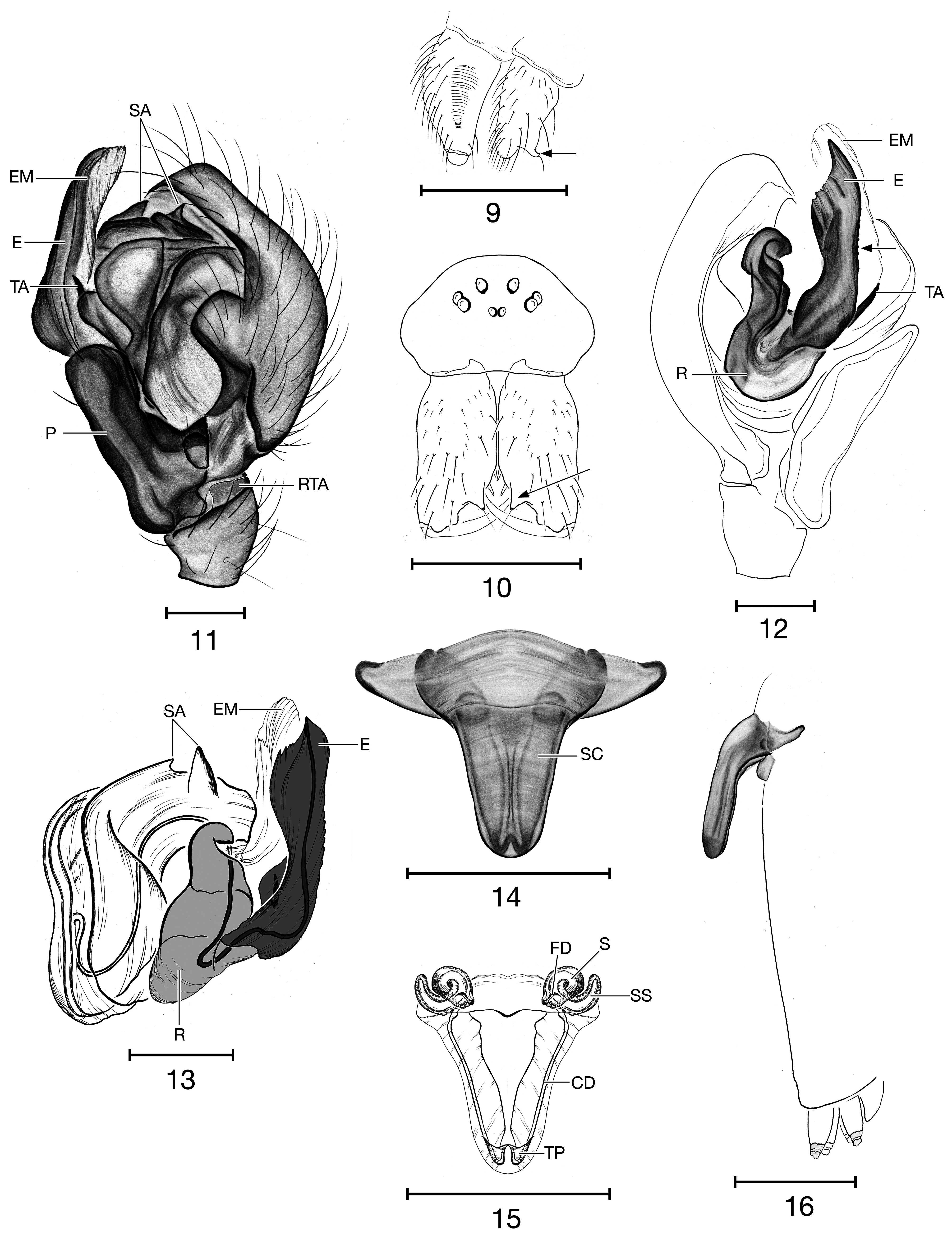
Diagnosis.— Oaphantes cryophilus n. sp. differs from O. pallidulus and O. prometheus n. sp. by their reduced tibial macrosetae, being half the tibia diameter in length, barely wider than regular setae, and abdomen covered with short semi-erect setae. Males of O. cryophilus n. sp. differ from the other species by the heavily carinated cheliceral retromargins and the endites bearing a large hook-shaped setose tubercle ( Fig. 9 View FIGURES 9–16 ). The male palps are diagnosed by the simpler paracymbium (P) without any obvious keel ( Fig. 11 View FIGURES 9–16 ) or proximal pockets (PPO). Females are diagnosed by the broad anterior margin of the epigynum, slightly narrowing into a large, shorter scape (SC), ∼ 1\5 of the abdomen length ( Figs 14, 16 View FIGURES 9–16 ).
Description.— Male (n=3): Total length: 2.13–2.50; carapace length: 0.90–1.04; carapace width: 0.72–0.94; carapace, smooth, shiny, light yellow orange (130M), carapace slightly elevated in cephalic region, bearing 5–6 erect setae along midline. Sternum light yellow orange (130M). Chelicerae light yellow orange (130M), promargin with 2–3 teeth and bearing a large mastidion ( Fig. 10 View FIGURES 9–16 ), retromargin carinated with 3–5 sharp denticles, presence of setae-tipped tubercles on cheliceral surface. Cheliceral stridulatory organ visible with ∼ 20 striae. Endite light yellow orange (130M) with a single large setose hook-shaped tubercle ( Fig. 9 View FIGURES 9–16 ). Abdomen off-white (7500M), subcylindrical, pointed apically, covered with short semi-erected setae; ventral surface of abdomen bearing oval striated epigastric plates. Legs long and slender, light yellow orange (130M), formula 1-4-2-3; tibia I–IV with 2 short dorsal macrosetae; metatarsus I with dorsal trichobothrium, Tm I 0.52, Tm IV absent; coxae IV with stridulatory pick. Palpal femur with stridulatory pick. Male palp with a simple paracymbium (P) without obvious keel or proximal pocket, but bearing a proximal protuberance with three short setae, and 2 long setae on its apical part ( Fig. 11 View FIGURES 9–16 ); embolus (E) straight, long, dentate and extending beyond the cymbium ( Figs 12, 13 View FIGURES 9–16 ); embolic membrane (EM) long ( Figs 12, 13 View FIGURES 9–16 ); lamella characteristica (LC) reduced and spine-like ( Figs 12, 13 View FIGURES 9–16 ); terminal apophysis (TA) absent; 2 teeth on distal suprategular apophysis (SA) ( Figs 11, 13 View FIGURES 9–16 ); reduced retrolateral tibial apophysis (RTA) ( Fig. 11 View FIGURES 9–16 ).
Female (n=5): Total length: 2.23–2.31; carapace length: 0.86–0.90; carapace width: 0.71–0.80; carapace smooth, shiny, colouration as in male, carapace not elevated in cephalic region, bearing 4–5 erect setae along midline. Colouration of sternum and chelicerae as in male, promargin with 4 medium sized teeth, retromargin with 4–5 denticles, presence of setae-tipped tubercles on cheliceral surface. Cheliceral stridulatory organ visible with ∼ 16 striae. Endite colouration as in male, without a setose tubercle. Abdomen colouration as in male, sub-cylindrical, pointed apically, covered with short semi-erect setae; ventral surface of abdomen bearing oval striated epigastric plates. Legs long and slender, light yellow orange (FFD700), formula 1-4-2-3; tibia I–IV with 2 short dorsal macrosetae; metatarsus I with dorsal trichobothrium, Tm I 0.51, Tm IV absent; coxae IV with stridulatory pick. Palpal femur with stridulatory pick. Epigynum defined by the broad, anterior margin of the scape, slightly narrowing toward the apex, creating a short, broad scape (SC), ∼ 1\5 of the abdomen length ( Figs 14, 16 View FIGURES 9–16 ); coiled spermathecae (S), secondary spermathecae (SS) elongate, curved and directed anteriorly ( Fig. 15 View FIGURES 9–16 ); copulatory openings located on the underside of the scape near the apex and associated with terminal pockets (TP) ( Fig. 15 View FIGURES 9–16 ); copulatory ducts long (CD) ( Fig. 15 View FIGURES 9–16 ); fertilization ducts (FD) short and sinuous ( Fig. 15 View FIGURES 9–16 ).
Distribution.— Restricted to the West Coast of North America from the southern Sierra Nevada of California to southwestern British Columbia.
Habitat.—The species is troglophilic with many records from caves in Sequoia National Park, the southern limit of its distribution. Interestingly, the northern records are only from the surface, particularly conifer forests (hemlock). This species has also been collected in a conifer forest in January, under snow manually and by pitfall, and is believed to be active in winter.
Etymology.— The epithet cryophilus refers to the presumed affinities of the species for colder conditions.

| USFS |
Rocky Mountain Forest and Range Experiment Station |
| RBCM |
Royal British Columbia Museum |
| BM |
Bristol Museum |
No known copyright restrictions apply. See Agosti, D., Egloff, W., 2009. Taxonomic information exchange and copyright: the Plazi approach. BMC Research Notes 2009, 2:53 for further explanation.
|
Kingdom |
|
|
Phylum |
|
|
Class |
|
|
Order |
|
|
Family |
|
|
Genus |
Oaphantes cryophilus
| Paquin, P., Dupérré, N., Buckle, D. J. & Ubick, D. 2020 |
Oaphantes
| Elliott, W. R. & Reddell, J. R. & Rudolph, D. C. & Graening, G. O. & Briggs, T. S. & Ubick, D. & Aalbu, R. L. & Krejca, J. & Taylor, S. J. 2017: 181 |
| Paquin, P. & Duperre, N. & Reddell, J. R. 2009: 51 |