
Orthodes cynica Guenée Cynical Quaker, 1852
|
publication ID |
https://doi.org/ 10.11646/zootaxa.2380.1.1 |
|
DOI |
https://doi.org/10.5281/zenodo.5320362 |
|
persistent identifier |
https://treatment.plazi.org/id/7156EC10-1A21-F47A-3D82-4CA81EF5FCB7 |
|
treatment provided by |
Felipe |
|
scientific name |
Orthodes cynica Guenée Cynical Quaker |
| status |
|
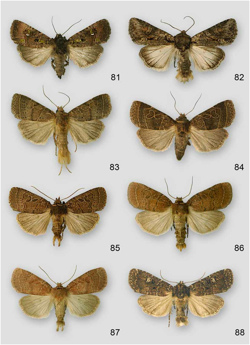
46. Orthodes cynica Guenée Cynical Quaker View in CoL
( Figs. 83–85 View FIGURES 81–88 , Map 46)
Identification: Forewing length 13–15 mm. Forewing ground color varies from dark gray to dark ferruginous. Antemedial line is black and slightly scalloped. Orbicular and reniform spots are ground color outlined in white. Postmedial line is black and angled from costa to reniform spot then curves around reniform to posterior margin. A series of distal triangular spots is associated with the postmedial line from reniform to posterior margin. Subterminal line is usually present, is white to pale ferruginous, and separates the darker subterminal area from the lighter terminal area. Hindwing is gray with pale ferruginous to white fringe.
Darker specimens have ferruginous antemedial, postmedial, and subterminal lines with no spots associated with the subterminal line. Easily distinguished from O. majuscula by the lack of a black spot between the patagia and the orbicular and reniform spots outlined in white.
Flight period: Late April to June and August, multiple brooded.
Collected localities: North Carolina : Haywood Co., Balsam Mountain picnic area on Flat Creek Trail, Cove Creek Road, Purchase Knob, Purchase Knob 1.1 rd. mi from house, Purchase Knob at house, Purchase Knob at lower creek, Purchase Knob NW of house, Purchase Knob on road in meadow, Balsam Mountain Road 6.1 mi north of Blue Ridge Parkway Polls Gap Rough Fork Trail; Swain Co., Beetree Ridge, Big Cove Road site b, Big Cove Road site c, Big Cove Road site p, Big Cove Road site w, 1 road mi north Clingmans Dome, 13.5 mi NE GSMNP entrance on Hwy. 441 Thomas Divide Trail, 15.2 mi NE GSMNP entrance on Hwy. 441 Deep Creek Trail, 8.3 mi NW GSMNP entrance on Hwy. 441 Kephart Prong Trail, Oconaluftee Staff Apartments, 0.1 mi NE Twentymile Ranger Station, 0.2 mi NE Twentymile Ranger Station. Tennessee: Blount Co., 0.2 mi SW of Campsite 13 on Wolf Ridge Trail, 0.1 mi west Gregory Bald, Gregory Bald Trail E of Campsite 13, Gregory Bald Trail north of Campsite 13, 0.2 mi NE of Parsons Bald on Wolf Ridge Trail, Parsons Bald, Spence Field, Campsite 6 head of spring Scott Mountain Trail, Tremont; Cocke Co., Cosby 3.6 mi E junction Hwy. 32, Cosby ATBI house, Cosby Campground area, Cosby Campground, Cosby Campground vic. Trailhead, Cosby Ranger Station, Foothills Parkway East, Foothills Parkway 1 st parking lot nr. N Cosby; Sevier Co., Greenbrier Ranger Station, E of Campsite 20, Campsite 20, 6 mi south Sugarlands Visitor Center, 7 mi south Sugarland Visitor Center. (187 specimens)
Elevation range: 1360–5960 ft. (415–1817 m)
General distribution: Ranges across Canada from Nova Scotia to Saskatchewan. In the U.S. it is distributed from Maine to North Carolina and west to North Dakota, Colorado, and Texas.
Larval hosts: This is one of the most common species in the Park, but the natural host is unknown. Larvae obtained from eggs were reared on common dandelion ( Taraxacum officinale F.H. Wigg. , Asteraceae ) ( Godfrey 1972).
MAP 47. Collecting localities of Orthodes cynica .
No known copyright restrictions apply. See Agosti, D., Egloff, W., 2009. Taxonomic information exchange and copyright: the Plazi approach. BMC Research Notes 2009, 2:53 for further explanation.
|
Kingdom |
|
|
Phylum |
|
|
Class |
|
|
Order |
|
|
Family |
|
|
Genus |