
Oxypoda (Baeoglena) nova BERNHAUER, 1902
|
publication ID |
https://doi.org/ 10.21248/contrib.entomol.69.1.001-032 |
|
publication LSID |
lsid:zoobank.org:pub:016AAB3F-8AE2-4759-B95A-DEAA074768CD |
|
persistent identifier |
https://treatment.plazi.org/id/320587A7-EB48-1D76-FF27-F970292AE4AF |
|
treatment provided by |
Felipe |
|
scientific name |
Oxypoda (Baeoglena) nova BERNHAUER, 1902 |
| status |
|
Oxypoda (Baeoglena) nova BERNHAUER, 1902 View in CoL
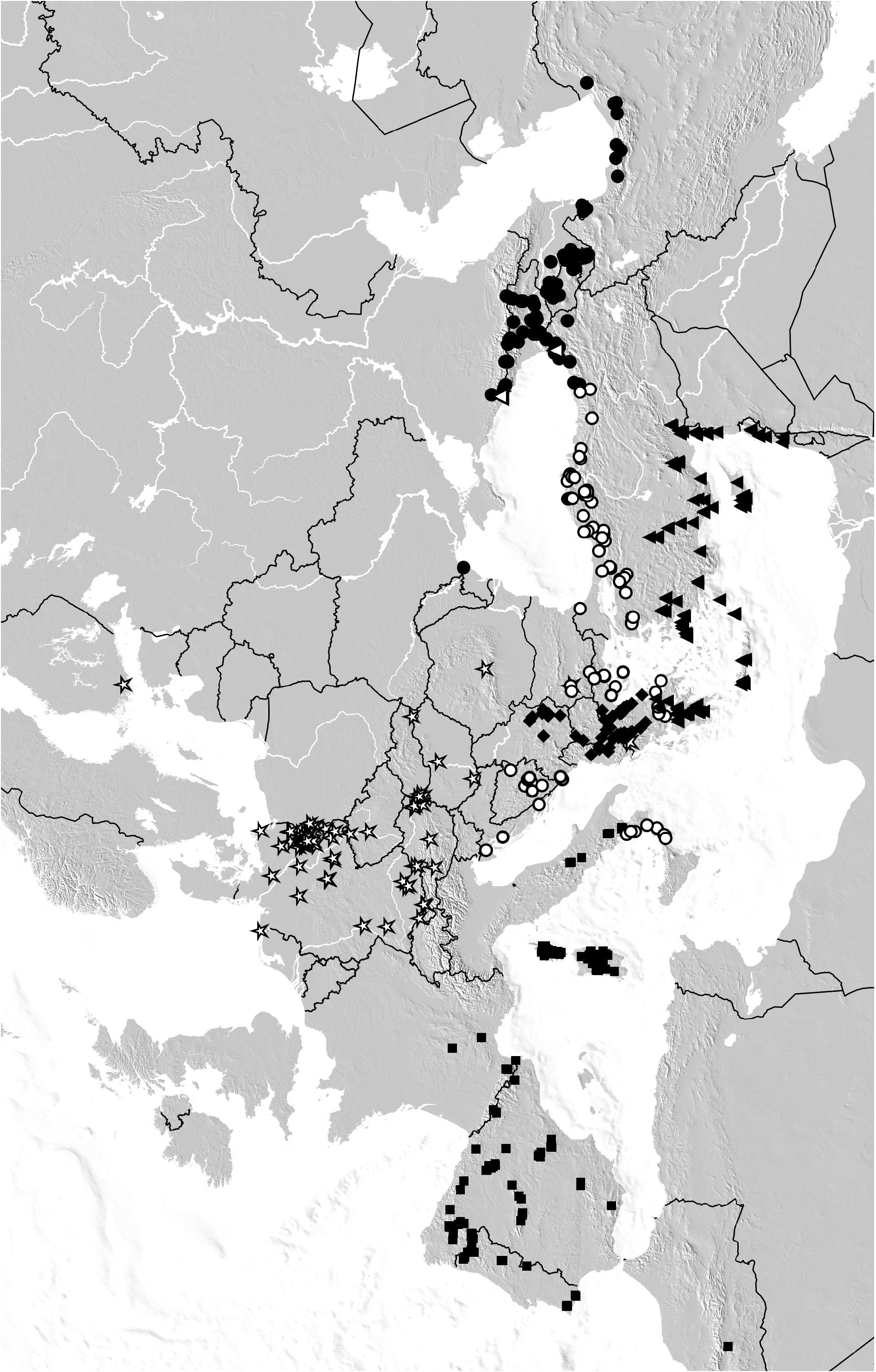
( Figs 23–28 View Figs 23–36 , Maps 1 View Map 1 , 5 View Map5 )
Oxypoda (Baeoglena) nova BERNHAUER, 1902: 180 View in CoL f.
Oxypoda (Mycetodrepa) giachinoi PACE, 2001: 131 View in CoL f.; syn. nov.
Type material examined: Lectotype [dissected prior to present study], present designation: “ nova Brnh , Türkei, Merkl / Chicago NHMus, M. Bernhauer Collection / Lectotypus Oxypoda nova Bernhauer / Oxypoda nova Bernhauer , det. V. Assing 2018” ( NHMW) . Paralectotypes: 1 ex. [abdomen missing]: “ Saj / nova Brh. Bosnien, Type. / Chicago NHMus, M. Bernhauer Collection ” ( FMNH) ; 1 ex. [abdominal apex missing]: “[locality illegible] / nova Brh. Bosnien, Type. / type / ex coll. Skalitzky / Typus Oxypoda nova M. Bernhauer / Oxypoda nova Bernhauer , det. V. Assing 2018” ( NHMW) ; 1: “Dalmatia, Reitter. / praecox Er ?, nach Smlg Epp / nova Brh Type / Chicago NHMus, M. Bernhauer Collection ” ( FMNH) .
Comment: The original description of O. nova is based on an unspecified number of syntypes from “ Bosnien (... Sarajevo ...), Dalmatien und der Türkei ” and from “ Italien und Spanien ” ( BERNHAUER 1902). Thus, as can be inferred from the revised distributions, the type material includes at least two, possibly even three, or even four species. Four specimens qualifying as syntypes were located in the Bernhauer collection and in the collections of the NHMW. A syntype from Turkey, the only male in fairly good condition among them, is designated as the lectotype.
PACE (2001) described O. giachinoi based on a male holotype and female paratype from “ Grecia, nom. Fthiótida, O. Oxià, str. Gardìki–Gramméni Oxià” and erroneously assigned the species to the subgenus Mycetodrepa THOMSON, 1859 . The illustrations of the aedeagus leave no doubt that O. giachinoi is conspecific with O. nova .
Material examined: Italy: Calabria: 1, Serra S. Bruno, 6 km W Mongiana , 1100 m, 21.VI.2001, leg. Wolf (cAss); 1, 14 exs., Calabria, Catena Costiera, L. Trifoglietti , 1300 m, leg. Angelini & Sabella ( MNB, cAss); 1, Catena Costiera, Fuscaldo ( CS) , 900 m, 5.VII.1988, leg. Angelini (cAss); 1 [teneral], Monti Orsomarso, Grisolia, Pantanelli ( CS) , 670 m, 4.VIII.1989, leg. Angelini (cAss); 1, Le Serre, M. Pecoraro ( CZ) , 1250 m, 27.VI.1987, leg. Angelini (cAss); 1, 1, Aspromonte, Santuario della Madonne di Polsi , 1000 m, 23.VI.1987, leg. Angelini (cAss); 1, Piano Aspromonte ( RC) , 1000 m, swamp, 1.V.1993, leg. Angelini & Sabella (cAss); 1, 2 exs., same data, but 12.VIII.1988, leg. Angelini (cAss); 1, 3 exs., Aspromonte, Gambarle, M. Basilico , 1100 m, 1.V.1993, leg. Angelini (cAss); 1, Aspromonte, Passo di Cancelo , 950 m, 19–30.VI.2001, leg. Wolf ( MNB) ; 1, 1, Fagnano Castello ( CS) , Lago Due Uomini, 39°33'N, 16°01'E, 1000 m, 25.IV.2015, leg. Tagliapietra & Zanetti (cZan); 8 exs., Aspromonte ( FMNH, NHMW) ; 7 exs., locality not specified ( NHMW) .
Croatia: 7, 8, Biokovo Planina, road to Sveti Jure , 1500 m, 9.VI.2006, leg. Schuh (cAss) ; 8 exs., Istria, Rijeka region, Primorje Gorski Kotar, Ucka , 1300–1350 m, 5.VI.2014, leg. Wolf ( MNB, cAss); 2, 2 exs., Mount Biokovo , leg. Besuchet ( MHNG, cAss); 1, 1, Velebit, “Costaria S”, leg. Leonhard ( FMNH) .
Montenegro: 2, 6 exs., Radoštak , leg. Paganetti ( NHMW, cAss) ; 1, locality not specified, leg. Reitter ( NHMW); 2, Kameno , leg. Paganetti ( FMNH) ; 1, 5 exs., Krivošije , leg. Paganetti, Bierig, Matcha ( FMNH) .
Bosnia-Herzegovina: 1, Mostar, Nevesinje, 14.VIII. 1977, leg. Lohse (cAss); 1, Gromiljak , 400 m, 5.V.1990, leg. Wunderle (cWun); 2 exs., Bjelasnica Planina , leg. Leonhard ( NHMW, cAss); 1 ex., Bjelasnica Planina, 1901 ( FMNH) ; 1 ex., Majevica Planina ( NHMW) ; 4, Sarajevo , V.1907 ( NHMW) ; 1, 1, Jablanica , leg. Formanek, Paganetti ( FMNH) ; 1, Trebevic , leg. Bierig ( FMNH) .
Greece: 13, 16, Makedhonía, NW Kavála, Pangéo, near ski resort, beech forest, 1700 m, 24.V.1999, leg. Assing (cAss); 7, 8, same data, but 1650 m (cAss); 3, 1, same data, but 1650 m, 28.V.1999 (cAss); 2, 1, same data, but 1200 m, 28.V.1999 (cAss); 1, same data, but road to ski resort, 1350 m, 24.V.1999 (cAss); 4, 5, Makedhonía , Dráma , Falakró , road to ski resort, 1500 m, pine forest, 26.V.1999, leg. Assing (cAss); 2, Makedhonía , Athos, leg. Schatzmayr ( FMNH); 2, 4, same data, but 1000 m, beech forest (cAss); 3 exs., Makedhonía , Drama region , West Rodopi , N Skaloti, Elatia Old Forest Village env., 1600 m, 13–14.VI.2002, leg. Wolf ( MNB, cAss); 1, E Thessaloniki, Chortiatis , 28.VI.1960, leg. Kühnelt ( NHMW); 7 exs., Chalkidiki , 12 km NW Megali Panagia, 40°28'N, 23°34'E, 1000 m, 21.V.2005, leg. Bayer ( MNB, cAss); 1, 19 km NW Drama, Falakro , road to ski resort, 41°18'N, 24°00'E, 1200 m, 14.V.2005, leg. Bahr et al. ( MNB); 2, 5, Evvoia, Oros Dirfys, N Kato Steni, 38°37'N, 23°52'E, 1120 m, fir forest, 8.IV.2001, leg. Assing (cAss); 4 exs., Evvoia, Limni, Drimona, Oros Xiros, above waterfall, 22–26.III.2016, leg. Esser & Niefeld ( MNB, cAss); 6, 8, 4 exs., Fokis, 25 km SSW Lamia, Kaloskopi , 38°42'N, 22°18'E, 1200 m, fir forest, 6.IV.2001, leg. Assing & Wunderle (cAss, cWun); 1, Fokis, Oros Lidorikiou, 1170 m, 11.VI.1991, leg. Giachino & Vailati (cAss); 1, Fokis, Oros Giona, 38°40'N, 22°19'E, 1650 m, 17.IV.2000, leg. Wunderle (cWun); 1, 1, Fokis, Oros Vardousia, W Diakofto, 38°42'N, 22°10'E, 1540 m, fir forest, 18.IV.2000, leg. Wunderle (cWun); 1, 2, Fthiotis, SSE Lamia , Oros Kallidromo, 38°44'N, 22°32'E, 1250 m, fir forest, 7.IV.2001, leg. Assing (cAss); 10, 6, 5 exs., SSE Lamia , Oros Kallidromo, 38°45'N, 22°32'E, 1200 m, fir forest, 7.IV.2001, leg. Assing & Wunderle (cAss, cWun) GoogleMaps .
Bulgaria: 1, Borovets–Maritsa , 7.VI.1967, leg. Besuchet ( MHNG); 1, Skakawitza, leg. Blagoeff ( MHNG) .
Turkey: Kirklareli: 1, 1 ex., Yeniceköy–Demirköy , 31.VII.1969, leg. Besuchet ( MHNG, cAss) . Çanakkale: 2, Kaz Dağı, Ayazma, 39°45'N, 26°54'E, 440 m, 11.IV.2010, leg. Brachat & Meybohm (cAss); 2, Kurucam Tepe , 39°43'N, 27°11'E, 430 m, 14.IV.2010, leg. Brachat & Meybohm (cAss) GoogleMaps . BalIkesir: 1, Kaz Dağı, Ayazma, 39°45'N, 26°51'E, 500 m, 11.IV.2010, leg. Brachat & Meybohm (cAss); 1, Kurucam Tepe , 39°41'N, 27°10'E, 740 m, 13.IV.2010, leg. Brachat & Meybohm (cAss) GoogleMaps . Bursa: 2, Karaorman, 39°55'N, 28°28'E, 440 m, 15.IV.2010, leg. Brachat & Meybohm (cAss); 1, Devecikonağı, 39°50'N, 28°26'E, 640 m, 16.IV.2010, leg. Brachat & Meybohm (cAss); 1, Uludağ , 40°08"N, 29°02'E, 1030 m, 17.IV.2010, leg. Brachat & Meybohm (cAss); 11 exs., Uludağ , 1300 m, 12.V.1976, leg. Besuchet & Löbl ( MHNG, cAss); 5 exs., Uludağ, 1500 m, 13.V.1976, leg. Besuchet & Löbl ( MHNG); 2, Soğukpınar, 40°05'N, 29°05'E, 1220 m, 18.IV.2010, leg. Brachat & Meybohm (cAss); 2, 1, Kocayayla, 39°56'N, 29°16'E, 1200 m, 18.IV.2010, leg. Brachat & Meybohm (cAss); 1, Samanlı Dağları, 40°28'N, 29°49'E, 780 m, 19.IV.2010, leg. Brachat & Meybohm (cAss); 1, 2, Samanlı Dağları, 40°31'N, 29°50'E, 720 m, 19.IV.2010, leg. Brachat & Meybohm (cAss); 1, 1, Elmalı, 40°31'N, 29°54'E, 1000 m, 20.IV.2010, leg. Brachat & Meybohm (cAss); 4 exs., S Bursa, 500 m, 12.V.1976, leg. Besuchet & Löbl ( MHNG); 1 ex., S Bursa, 22.VII.1969, leg. Besuchet ( MHNG) GoogleMaps . Kocaeli: 1, N Hereke , 40°49'N, 29°41'E, 460 m, 6.V.2012, leg. Brachat & Meybohm (cAss) GoogleMaps . Sakarya: 1, 2, 17 km N Hendek , 40°53'N, 30°46'N, 650 m, 3.V.2012, leg. Brachat & Meybohm (cAss) . Bolu: 1, Yedigöller Milli Park, 40°53'N, 31°41'N, 1720 m, 28.IV.2012, leg. Brachat & Meybohm (cAss); 1, 2, 25 km S Bolu, 40°38'N, 31°37'N, 1580 m, 30.IV.2012, leg. Brachat & Meybohm (cAss); 2, Kartalkaya, 40°36'N, 31°48'E, 1820 m, 25.IV.2014, leg. Brachat & Meybohm (cAss); 4, 4, Kartalkaya , 40°37'N, 31°49'E, 1720 m, 25.IV.2014, leg. Brachat & Meybohm (cAss); 6 exs., 9 km N Mengen, 750 m, 23.V.1976, leg. Besuchet & Löbl ( MHNG); 13 exs., Abant, 1500–1600 m, 22.V.1976, leg. Besuchet & Löbl ( MHNG); 2 exs, Abant, 1400 m, 25.V.1967, leg. Besuchet ( MHNG); 1 ex., Bolu env., Ömerler, 800 m, 21.V.1976, leg. Besuchet & Löbl ( MHNG) GoogleMaps . Zonguldak: 2, 1, ca. 15 km W Devrek, 41°14'N, 31°52'E, 700 m, beech forest with Rhododendron undergrowth, litter sifted, 26.III.2010, leg. Assing (cAss); 18 exs., S Zonguldak, 500 m, 23.V.1976, leg. Besuchet & Löbl ( MHNG); 2 exs., 17 km N Safranbolu , 1000 m, 16.V.1976, leg. Besuchet & Löbl ( MHNG) GoogleMaps . Karabük: 1, pass W Eskipazar , 40°58'N, 33°23'E, 1400 m, beech forest, litter sifted, 26.III.2010, leg. Assing (cAss) GoogleMaps . Kastamonu: 1, Ilgaz Dağı, Ballık, 41°12'N, 33°48'E, 1040 m, 26.IV.2014, leg. Brachat & Meybohm (cAss); 1, Ilgaz Dağı , Tüfekçi , 41°06'N, 33°44'E, 1380 m, 27.IV.2014, leg. Brachat & Meybohm (cAss); 1, S Küre , 41°45'N, 33°42'E, 1060 m, 27.IV.2014, leg. Brachat & Meybohm (cAss); 3, 4, N Küre , 41°53'N, 33°42'E, 880 m, 27–28.IV.2014, leg. Brachat & Meybohm (cAss); 4 exs., Inebolu – Küre , 700 m, 18.V.1976, leg. Besuchet & Löbl ( MHNG); 28 exs., 5 km S Küre, 1200 m, 18.V.1976, leg. Besuchet & Löbl ( MHNG, cAss); 5 exs., 5 km N Küre, 600 m, 18.V.1976, leg. Besuchet & Löbl ( MHNG); 4 exs., S Inebolu, 600 m, 18.V.1976, leg. Besuchet & Löbl ( MHNG); 3 exs., pass 15 km N Tosya, Ilgaz Dağı, 1600– 1700 m, 19.V.1976, leg. Besuchet & Löbl ( MHNG); 1 ex., Ilgaz Dağı, Diphan, 1300 m, 17.V.1976, leg. Besuchet & Löbl ( MHNG); 7 exs., 32 km N Tosya, Karadere, 1400 m, 19.V.1976, leg. Besuchet & Löbl ( MHNG); 5 exs., 13 km E Ağli, 1200 m, 18.V.1976, eg. Besuchet & Löbl ( MHNG) GoogleMaps . Sinop: 1, SSW Sinop, 41°43'N, 34°55'E, 660 m, oak forest, sifted, 29.III.2009, leg. Assing (cAss); 1, 1, ca. 30 km S Ayancık, Çangal Dağı, 41°49'N, 34°39'E, 920 m, beech forest, sifted, 1.IV.2009, leg. Assing (cAss); 8 exs., Çangal Dağı, V.1957, leg. Schubert ( NHMW); 6 exs., same data, but VI.1959; 11 exs., same data, but VI.1960 ( NHMW); 2 exs., 29 km N Boyabat, Bürnük , 1250 m, 20.V.1976, leg. Besuchet & Löbl ( MHNG); 10 exs., 23 km N Boyabat, S Bektaş, 1100 m, 20.V.1976, leg. Besuchet & Löbl ( MHNG) GoogleMaps . Samsun: 1, 21 km NNE Havza, 41°09'N, 35°45'E, 950 m, Quercus-Carpinus forest, litter and moss sifted, 19.VII.2008, leg. Assing (cAss); 1, 25 km S Samsun, NE Asarcık , 41°05'N, 36°16'E, 880 m, Fagus-Quercus- Carpinus forest, litter in dry stream sifted, 20.VII.2008, leg. Assing (cAss); 1, 1, 31 km NE Havza, 41°12'N, 35°52'E, 670 m, beech forest, litter sifted, 19.VII.2008, leg. Assing (cAss) GoogleMaps . Ordu: 1 ex., 34 km SSE Gölköy, W Mesudiye , 40°26'N, 37°47'E, 1520 m, 14.VII.2008, leg. Schülke ( MNB) GoogleMaps . Gümüşhane: 1, 1 ex., ca. 25 km SW Gümüşhane, Tersundağı Geçidi, 40°18'N, 39°18'E, 2070 m, N-slope, spruce forest, litter and dead wood sifted, 24.VII.2006, leg. Assing (cAss, MNB); 1, ca. 50 km SW Trabzon, NE Kürtün , 40°42'N, 39°15'E, 1750 m, 27.VII.2006, leg. Schülke ( MNB) GoogleMaps .
Diagnosis: Winged species of mostly reddish coloration.
: median lobe of aedeagus ( Figs 23–26 View Figs 23–36 ) of distinctive shape, relatively large, approximately 0.45 mm long; ventral process strongly curved in lateral view and apically concave in ventral view; crista apicalis very small; crista basalis very narrow; apical lobe of paramere ( Fig. 27 View Figs 23–36 ) relatively short, barely half as long as basal portion; basal portion of paramere ( Fig. 27 View Figs 23–36 ) with distinctive dark structure and relatively short apical lobe.
: spermatheca ( Fig. 28 View Figs 23–36 ) of variable shape, relatively small, with bell-shaped apical cuticular invagination.
Distribution and natural history: The revised distribution of O. nova is remarkably discontinuous ( Maps 1 View Map 1 , 5 View Map5 ). In Italy, it is confined to the extreme south (Calabria). This population is separated from the geographically closest populations in the Balkans by the Adriatic and Ionian Seas or by approximately 1000 km on land (North Croatia). In the Balkans, it is distributed in the northwest ( Croatia, Bosnia-Herzegovina, Montenegro) and in the southeast (Northeast Greece, Bulgaria); moreover, there is an enclave in the south of mainland Greece. These regions are separated by the distributional range of O. kuehnelti . From the southeastern Balkans, the record from Morocco).
range continues along North Anatolia eastwards to Gümüşhane and overlaps with that of O. caucasica . The only plausible explanation of this remarkable distribution pattern is interspecific competition with other Baeoglena species ( O. fusina , O. kuehnelti , O. rectacia , possibly also O. caucasica ).
The examined material was mostly sifted from leaf litter and roots in various forest (deciduous, coniferous, mixed) and bush habitats, but was also found in swamps and on stream banks. The altitudes range from 400 to 2070 m. The specimens were found in March (4 records), April (28), May (35), June (12), July (9), and August (3). The respective number of records most likely reflects the collecting activity more than the actual phenology of the species.


No known copyright restrictions apply. See Agosti, D., Egloff, W., 2009. Taxonomic information exchange and copyright: the Plazi approach. BMC Research Notes 2009, 2:53 for further explanation.
|
Kingdom |
|
|
Phylum |
|
|
Class |
|
|
Order |
|
|
Family |
|
|
Genus |
Oxypoda (Baeoglena) nova BERNHAUER, 1902
| Assing, Volker 2019 |
Oxypoda (Baeoglena) nova BERNHAUER, 1902: 180
| BERNHAUER, M. 1902: 180 |