
Therlinya kiah, Gray & Smith, 2002
|
publication ID |
https://doi.org/ 10.3853/j.0067-1975.54.2002.1368 |
|
persistent identifier |
https://treatment.plazi.org/id/573AD206-134C-FFFE-DA5A-FC4AFF5BC6B6 |
|
treatment provided by |
Carolina |
|
scientific name |
Therlinya kiah |
| status |
sp. nov. |
Therlinya kiah View in CoL n.sp.
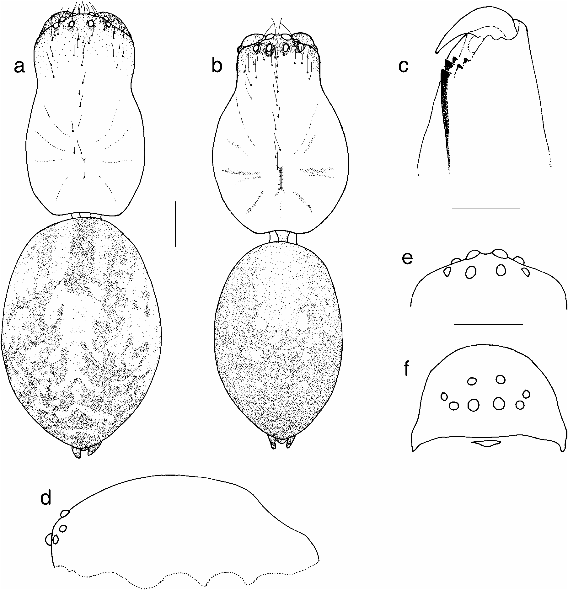
Figs. 1a,c–f View Figure 1 , 4a–h View Figure 4 , 6 View Figure 6
Type material. AUSTRALIA: NEW SOUTH WALES HOLOTYPE: Ƌ, KS58184 ( AMS), 1.5 km W of Kiah, on Towamba road, 37°09'S 149°50'E, 15 Apr. 1978 GoogleMaps , M. R. Gray , sheet webs in mossy bank along road, matured 26 Nov. 1978 . PARATYPES: ♀, KS58185, data as for holotype; ♀, KS58186, data as for holotype; (both mature at collection); Ƌ, KS34820, 4 mi. S of Rydal on Hampton Road , 33°32'S 150°03'E, 28 Nov. 1974 GoogleMaps , M. R. Gray; ♀, KS34819, 4 km S of Rydal at Sodwalls-Sydney turn-off, 33°32'S 150°03'E, 28 Nov. 1974 GoogleMaps , M. R. Gray, in small sheets with tube retreat in tussock grass on bank; Ƌ, ♀, KS75373, Mt Kaputar NP, 1.9 km W of Bark Hut Campsite, 30°16'50"S 150°07'55"E, 13 Nov. 2001 GoogleMaps , M. Gray, G. Milledge & H. Smith, sheet webs in grassy earth bank; Ƌ, KS63025 (to QM), Mount Kembla, Sydney Catchment Authority Reserve , 34°26'33"S 150°44'24"E, 11–15 Dec. 1998 GoogleMaps , L. Gibson, pitfall traps; Ƌ KS70037, Mount Kembla, Sydney Catchment Authority Reserve , 34°26'33"S 150°44'24"E, 6–10 Jun. 1999 GoogleMaps , L.
Gibson, pitfall traps; ♀, KS34822, Blue Mountains NP, 18 km E Woodford, 33°44'S 150°29'E, 17 Apr. 1974, M. R. Gray , vertical sheet web to ground burrow GoogleMaps ; ♀, KS58188, Brown Mountain, 14 km W of Bemboka, 36°37'S 149°25'E, 16 Apr. 1978, M. R. Gray , large sheet web in bank. AUSTRALIA: VICTORIA Ƌ, KS69651 GoogleMaps , ♀, KS58190, Kinglake NP, on SE slopes of Mt Slide, 4 km from SE entrance turn-off, 37°35'S 145°20'E, 29 Mar. 1978, M. R. Gray , in medium sized sheet webs GoogleMaps ; ♀, KS58192, Fairy Dell Forest Recreation Area, 6 km NW Wiseleigh, 37°41'S 147°47'E, 12 Apr. 1978, M. R. Gray , sheet web 15 cm out from double retreat GoogleMaps ; ♀, KS58193, between Glen Wills and Sunnyside, 52 km N of Omeo, 36°51'S 147°31'E, 13 Apr. 1974, M. R. Gray , 30 × 25 cm sheet web horizontally out from bank, 8 cm deep retreat GoogleMaps .
Other material. AUSTRALIA: NEW SOUTH WALES — 5 ♀♀, KS58187, data as for holotype; Ƌ, KS34824, Mount Werong near Oberon, 34°05'S 149°56'E, 3 Jul. 1972, G.S. Hunt, under logs; Ƌ, ♀, KS34829, ♀, KS58194, 8 km E of Bungendore on Braidwood Road, 31°15''S 149°27'E, 11 Dec. 1977, M. R. Gray , dry open sclerophyll, webs among grass on eroded creek banks 5–10 cm burrow; Ƌ, KS55757, Wiola Creek fire trail, Badja SF, 36°05'56"S 149°35'09"E, 13 Mar. 1999, J. Tarnawski & S. Lassau, CBCR003–025 ; ♀, KS58189, Bodalla SF, 8 km NNW Central Tilba, near Mt Dromedary turn-off, 36°16'S 150°03'E, 17 Apr. 1978, M. R. Gray, large sheet web suspended out from bank with strong entrance collar; Ƌ, KS63513, Beecroft Peninsula, northern headland of Jervis Bay , 35°03'03"S 150°47'21"E, 21–25 Aug. 1999, L. Gibson, pitfall traps; ♀, KS58202, Bellinger River SF, NW Thora, 30°25'03"S 152°45'30"E, 12 Nov. 1999, M. R. Gray & H.M. Smith, sheet webs in bank; ♀ KS59583, Bellinger River SF, data as above; ♀♀ KS75353, Bellinger River SF, 22 Nov. 2001, G. Milledge & H. Smith, in earth banks; ♀, KS34821, 2 miles W of Willi Willi on Carrai Rd, 30°56'S 152°27'E, M. R. Gray, 24 Apr. 1974, Baiami type” (sheet) web in moist bank; ♀, KS37191, Boorook SF, Boonoo Boonoo River , 28°48'25"S 152°11'03"E, 18 Feb. 1993, M. R. Gray & G. Cassis, pitfall trap; ♀ KS75371, Mt Kaputar NP, 0.8 km W of Bark Hut Campsite, 30°17'09"S 150°08'12"E, 13 Nov. 2001, M. Gray, G. Milledge & H. Smith, sheet web in grassy earth bank; ♀ KS75372, Mt Kaputar NP, 1.9 km W of Bark Hut Campsite, 30°16'50"S 150°07'55"E, other data as above; ♀♀ KS75374–5, Mt Kaputar NP, 0.8 km W of Coryah Gap, 30°16'44"S 150°07'40"E other data as above; ♀♀ KS75376–7, Mt Kaputar NP, 1.6 km W of Coryah Gap, 30°16'13"S 150°07'11"E, other data as above; ♀♀ KS 75378, Mt Kaputar NP, 0.3 km W of Bark Hut, 30°17'22"S 150°08'24"E, other data as above GoogleMaps . AUSTRALIA: QUEENSLAND Ƌ QM S42308 View Materials , Levers Plateau , 28°19'S 152°51'E, 2 Dec. 1991 – 6 Jan. 1992, D.J. Cook, 720 m, rainforest, pitfall GoogleMaps .
AUSTRALIA: VICTORIA ♀, KS58191, Kinglake NP, on SE slopes of Mt Slide, 4 km from SE entrance turn-off, 37°35'S 145°20'E, 29 Mar. 1978, M. R. Gray , in medium sized sheet webs GoogleMaps ; 3♀♀, KS3659, Lind NP, 19 km W of Cann River, Euchre Valley Road, 37°35'S 148°57'E, 24 Mar. 1978, M. R. Gray , sheet webs GoogleMaps ; ♀, KS3648, Alfred NP, 2 km W Governors Bend pull-in, 37°33'S 149°21'E, 23 Mar.1978, M. R. Gray , roadside bank below rainforest, sheet webs c. 25 cm long GoogleMaps ; ♀, KS45206, Buchan Caves Reserve, 37°30'S 148°15'E, 25 Mar. 1978, M. R. Gray GoogleMaps .
Diagnosis. CL 2.90–5.00. Separated from other females by large width across paired epigynal fossa (twice scape width) and broadened dorsal part of scape; from north Queensland species by presence of obvious leg banding; and from other males by the wide cymbium and bulb.
plug on LHS); e, dorsal—internal genitalia. Scale line 0.5 mm. (c, KS34794; d, KS34797; e, KS34795).
Male (holotype). BL 7.47, CL 3.59 (3.35–4.78), CW 2.45, CapW 1.35, EGW 0.96, LL 0.47, LW 0.49, SL 1.75, SW 1.45. Legs: 1423 (I 13.88, II 12.12, III 10.12, IV 12.24); ratio tibia I length:CW = 1:0.74. Male palp: Fig. 4a,b View Figure 4 . Cymbium wide with strongly developed retrolateral flange. Bulb wide with large, rounded tegular lobe placed retrolaterally. Embolus origin retrolateral. Stem of T-shaped conductor prolaterally directed, posterior limb placed prolaterally; tegular window large, placed basally. RTA apophysis dorsad, hidden in ventral view; RVTA broad, beak-like apex turned toward lower side in ventral view.
Female (KS58185). BL 7.39, CL 3.51 (2.90–5.00), CW 2.04, CapW 1.76, EGW 1.04, LL 0.53, LW 0.53, SL 1.51, SW 1.31. Standard colour pattern. Legs: 1423 (I 11.50, II 10.00, III 8.17, IV 10.17); ratio tibia I length:CW = 1:0.72.
Epigynum: Fig. 4c–g View Figure 4 . Scape moderately long, dorsobasal part of scape markedly broadened for half or more of scape length, with most of scape length placed in front of epigastric groove; ventral scape width varies from narrow to moderately broad; sides more or less parallel or, if divergent, scape relatively narrow; in side view distoventral scape protuberant; epigynal fossae oriented vertically. Internal genitalia: Fig. 4h View Figure 4 .
Variation. There is a noticeable variation in body size (including male palp size) which appears to be seasonal. Specimens collected as adults in late summer–winter are medium–large, whereas those from spring–early summer are small–medium in size. Despite the individual variation observed in characters such as scape shape and palpal width, the overall pattern is one of a single, widely distributed but variable species.
Distribution. Eastern New South Wales and eastern Victoria. The only record of Therlinya from Tasmania (female, KS29134, Punchbowl, Launceston) may belong to this species but more material, including males, is needed before a definite species allocation is made.
Etymology. The specific name is taken from the type locality and is an Aboriginal word meaning “a beautiful place”.


| R |
Departamento de Geologia, Universidad de Chile |
| QM |
Queensland Museum |
No known copyright restrictions apply. See Agosti, D., Egloff, W., 2009. Taxonomic information exchange and copyright: the Plazi approach. BMC Research Notes 2009, 2:53 for further explanation.
|
Kingdom |
|
|
Phylum |
|
|
Class |
|
|
Order |
|
|
Family |
|
|
Genus |