
Chrysopetalum elegantoides Aguado, Capa & San Martín, 2003
|
publication ID |
https://doi.org/ 10.11646/zootaxa.4521.1.3 |
|
publication LSID |
lsid:zoobank.org:pub:12685FBF-7507-48D0-9753-D747B6ECC778 |
|
DOI |
https://doi.org/10.5281/zenodo.5950275 |
|
persistent identifier |
https://treatment.plazi.org/id/039187C9-361C-FFA0-6199-F9D9D5EB94D5 |
|
treatment provided by |
Plazi |
|
scientific name |
Chrysopetalum elegantoides Aguado, Capa & San Martín, 2003 |
| status |
|
Chrysopetalum elegantoides Aguado, Capa & San Martín, 2003 View in CoL
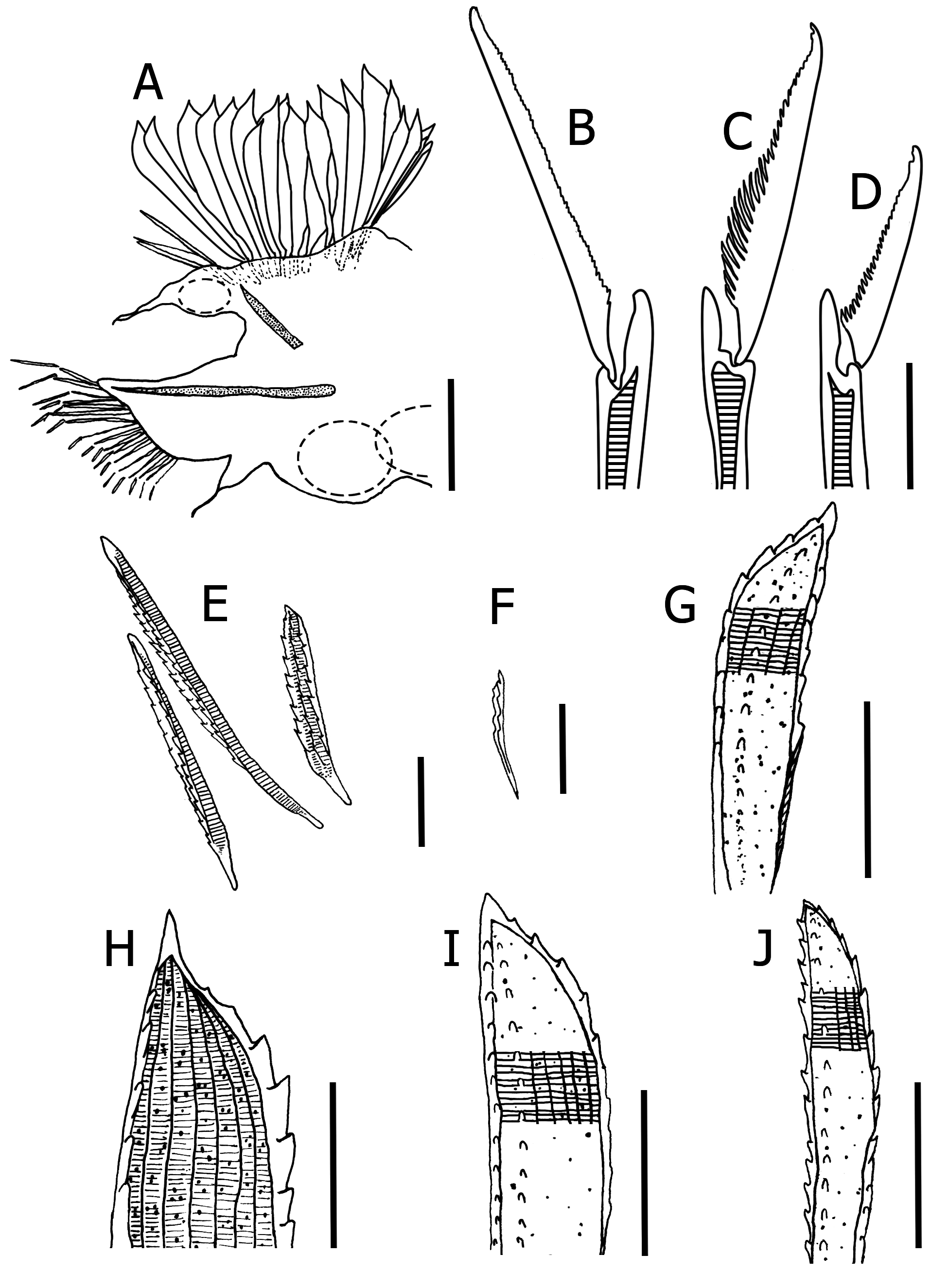
( Figures 4 View FIGURE 4 A–J, 5, 8, 14F, 15C)
Chrysopetalum elegantoides Aguado, Capa & San Martín, 2003 View in CoL : 84–88, figs. 1-2. Type locality: Rosario Beach (7°38’30’’N, 81°41’4’’W) and others localities near to Coiba Island, Panama, on dead coral, at 2.5 m depth.
Material examined. Guerrero: ECOSUR-P2939, five spec. (La Quebrada, Acapulco, 16°50’47’’N, 99°54’55’’W, on Pinctada mazatlanica ( Hanley, 1856) , 6 m, May 25, 2000, coll. A. Medina); ECOSUR-P2940, one spec. ( Los Cantiles , Acapulco, 16°50’45’’N, 99°54’55’’W, on bivalve shells, 8 m, May 26, 2000, coll. A. Medina) GoogleMaps ; UMAR- Poly 856, five spec. (Coral Beach, Ixtapa, 17°40’36’’N, 101°39’22’’W,on dead coral, 4 m, September 19, 2007, coll. M.S García-Madrigal) GoogleMaps ; UMAR-Poly 857, one spec. ( La Ropa Beach , 17°37’37’’N, 101°32’46’’W, rocks, 0.5 m, September 19, 2007, coll. M.S. García-Madrigal) GoogleMaps ; UMAR-Poly 858, four spec. ( Manzanillo Beach , 16°50’31’N, 99°54’37’’W, on sponge from pier piling, 4 m, September 21, 2007, coll. M.S. García-Madrigal) ; UMAR-Poly 859, two spec. ( La Quebrada , Acapulco, 16°50’45’’N, 99°54’55’’W, September 21, 2007, coll. M.S. García-Madrigal) GoogleMaps ; UMAR-Poly 860, four spec. ( La Roqueta Island , Acapulco, 16°49’21’’N, 99°54’29’’W, 0–4 m, September 21, 2007, coll. M.S. García-Madrigal) GoogleMaps ; UMAR-Poly 861, one spec. ( Zacatoso , 17°03’46’’N, 100°19’46’’W, on stony coral, 9.1 m, December 1, 2010, coll. S.D. Güenduláin) GoogleMaps ; UMAR-Poly 862, one spec. ( Caleta de Chón , 17°36’49’’N, 101°33’18’’W, on stony coral, 4.3–6.1 m, December 2, 2010, coll. S.D. Güenduláin) GoogleMaps ; UMAR-Poly 863, three spec. ( Morros de Potosí , 17°38’49’’N, 101°37’44’’W, on Pocillopora damicornis ( Linnaeus, 1758) , 6.1–11.7 m, December 3, 2010, coll. S.D. Güenduláin) GoogleMaps ; UMAR-Poly 864, two spec. ( Morros de Potosí , 17°38’49’’N, 101°37’44’’W, on P. damicornis , 11.7 m, December 7, 2010, coll. S.D. Güenduláin & R.N.) GoogleMaps ; Oaxaca : ECOSUR-P0339, one spec. (Tangolunda Bay, Huatulco, 15°46’20’’N, 96°05’49’’W, on coral, April 1, 1986, coll. G. Sandoval) GoogleMaps ; UMAR-Poly 865, three spec. ( El Arrocito Beach , 15°45’38’’N, 96°06’00’’W, on dead coral, 3 m, May 25, 2000, coll. J.R. Bastida- Zavala); UMAR-Poly 866, six spec. (Estacahuite Bay, 15°40’05’’N, 96°28’56’’W, dead coral, 3 m, April 9, 2005, coll. J.R. Bastida-Zavala et al.) GoogleMaps ; UMAR-Poly 867, three spec. ( La Tijera , 15°41’14’’N, 96°26’34’’W, on dead coral, 3 m, April 30, 2005, coll. J.R. Bastida-Zavala) GoogleMaps ; UMAR-Poly 868, one spec. ( Estacahuite Bay , 15°40’05’’N, 96°28’56’’W, on rocks, 3m, July 30, 2005, coll. G. Ruíz-Cancino) GoogleMaps ; UMAR-Poly 869, five spec. ( Estacahuite Bay , 15°40’05’’N, 96°28’56’’W, on dead coral, 1 m, September 10, 2005, coll. J.R. Bastida-Zavala et al.) GoogleMaps ; UMAR-Poly 870, four spec. ( Estacahuite Bay , 15°40’05’’N, 96°28’56’’W, on rocks, 3 m, August 25, 2006, coll. J.R. Bastida-Zavala et al.) GoogleMaps ; UMAR-Poly 871, thirty eight spec. ( La Tijera , 15°41’14’’N, 96°26’34’’W, on dead coral, 2–4 m, September 12, 2006, coll. J.R. Bastida-Zavala) GoogleMaps ; UMAR-Poly 872, sixteen spec. ( Estacahuite Bay , 15°40’05’’N, 96°28’56’’W, 4 m, December 1, 2006, coll. M.S. García-Madrigal) GoogleMaps ; UMAR-Poly 873, one spec. (mouth of Corralero Lagoon , 16°14’11’’N, 98°11’36’’W, on sabellariid tubes, 1 m, December 8, 2006, coll. J.R. Bastida-Zavala et al.) GoogleMaps ; UMAR-Poly 874, one spec. ( Panteón Beach , 15°39’50’’N, 96°29’43’’W, on dead coral, March 31, 2007, coll. Y. Solís & P. Maza) GoogleMaps ; UMAR-Poly 875, two spec. (main pier, Puerto Ángel , 15°39’55’’N, 96°29’28’’W, on dock pilings, 0.5 m, May 20, 2007, coll. F. Cortés-Carrasco) GoogleMaps ; UMAR-Poly 876, one spec. ( El Arrocito Beach , 15°45’38’’N, 96°06’00’’W, July 4, 2007, coll. B. Martínez et al.) GoogleMaps ; UMAR-Poly 877, one spec. ( Chacahua Lagoon , 15°58’07’’N, 97°41’01’’W, on rocks, intertidal, November 10, 2007, coll. P. Hernández) GoogleMaps ; UMAR-Poly 878, two spec. ( Chacahua Lagoon , 15°58’07’’N, 97°41’01’’W, on sabellariid colony, 0.5 m, April 3, 2008, coll. J. Jarquín) GoogleMaps ; UMAR-Poly 879, one spec. ( Chacahua Lagoon , 15°58’07’’N, 97°41’01’’W, on artificial mount, April 3, 2008, coll. J. Jarquín) GoogleMaps ; UMAR-Poly 880, two spec. ( La Tijera , 15°41’14’’N, 96°26’34’’W, on dead coral, 3 m, April 17, 2009, coll. F. Cortés-Carrasco) GoogleMaps ; UMAR-Poly 881, six spec. ( Montosa Island , 15°45’52’’N, 96°05’04’’W, on Pocillopora damicornis , 2.7–5.8 m, February 22, 2010, coll. R. Granja-Fernández & S. D. Güenduláin) GoogleMaps ; UMAR-Poly 882, two spec. ( San Agustín Bay , 15°41’23’’N, 96°14’05’’W, on P. damicornis , 3.3–6.4 m, February 23, 2010, coll. R. Granja-Fernández & S. D. Güenduláin) GoogleMaps ; UMAR-Poly 883, six spec. ( Estacahuite Bay , 15°40’05’’N, 96°28’56’’W, on P. damicornis , 6.4–9.7 m, March 26, 2010, coll. A. López- Pérez & R. Zepeta); UMAR-Poly 884, four spec. (Salchi, 15°40’05’’N, 96°28’56’’W, stony coral, 6.1–7.9 m, March 26, 2010, coll. A. López-Pérez) GoogleMaps ; UMAR-Poly 885, three spec. ( Mazunte , 15°39’42’’N, 96°33’21’’W, on stony coral, 4.5 m, June 3, 2010) GoogleMaps ; UMAR-Poly 886, six spec. ( Mazunte , 15°39’42’’N, 96°33’21’’W, on P. damicornis , 7.5 m, August 11, 2010, coll. A. López-Pérez & R. Zepeta) GoogleMaps .
Description. Based mainly on the largest complete specimen, 8.7 mm long, 1.3 mm wide, 68 segments. Body rectangular and wide in the most anterior segments. Body yellow to orange. Paleae fans yellow and iridescent, slightly imbricated over dorsum. Prostomium rounded and completely visible among the first four segments. Two lateral subulate antennae; a small median antenna inserted between two pairs of eyes. Two pairs of reddish eyes, first pair slightly larger than second pair. Nuchal fold smaller than prostomium. Two pear-shaped palps, visible under the lateral antennae. Small and subtriangular mouth fold between third and fourth segment. Eversible proboscis with two slim stylet.
Parapodium from the tenth segment. Notochaetae separate in three main groups and two subgroups ( Fig. 4A View FIGURE 4 ). Lateral group inserted over the dorsal notoaciculum, comprising 3–6 slender and symmetrical paleae with 2–5 ribs and one raised rib ( Fig. 4E View FIGURE 4 ); over dorsal cirrus 3–5 small and slender spines ( Fig. 4F View FIGURE 4 ). As sub-unit 1, 1–2 asymmetrical and serrated paleae with 6–7 ribs and one raised rib ( Fig. 4G View FIGURE 4 ). Main group, comprising 12–15 asymmetrical and strongly serrated paleae with 5–7 raised ribs ( Fig. 4H View FIGURE 4 ). As sub-unit 2, three larger paleae (1/4 larger than main paleae) with 6–7 ribs and one raised rib ( Fig. 4I View FIGURE 4 ). Median group, comprising 3–4 symmetrical and spine-like paleae, slightly smaller than main paleae with 4–5 ribs and 1 raised rib ( Fig. 4J View FIGURE 4 ). The serration on all paleae groups is present in both lateral margins of each palea, in main and median group the serration is more marked only in one side margin. Neuropodium large and leaf-shape. Heterogomph neurochaetae composed of three groups ( Figs 4 View FIGURE 4 B–D). Neurochaetiger with 1–3 superior spinigers with a serrated straight blade. First three segments neurochaetaewith superior spinigers only. Mid-superior group and mid-inferior group indistinguishable, composed of 13–16 falcigers with medium and toothed blades (1/2 of spiniger blade length). Inferior group of 3–4 falcigers with short and serrated blades (1/4 of spiniger blade length). Pygidium rounded, with two anal cirri.
Habitat. Intertidal to subtidal (0.5–11.7 m). Collected from sponges, pier pilings, as epibionts of mollusks, in dead coral and rocks.
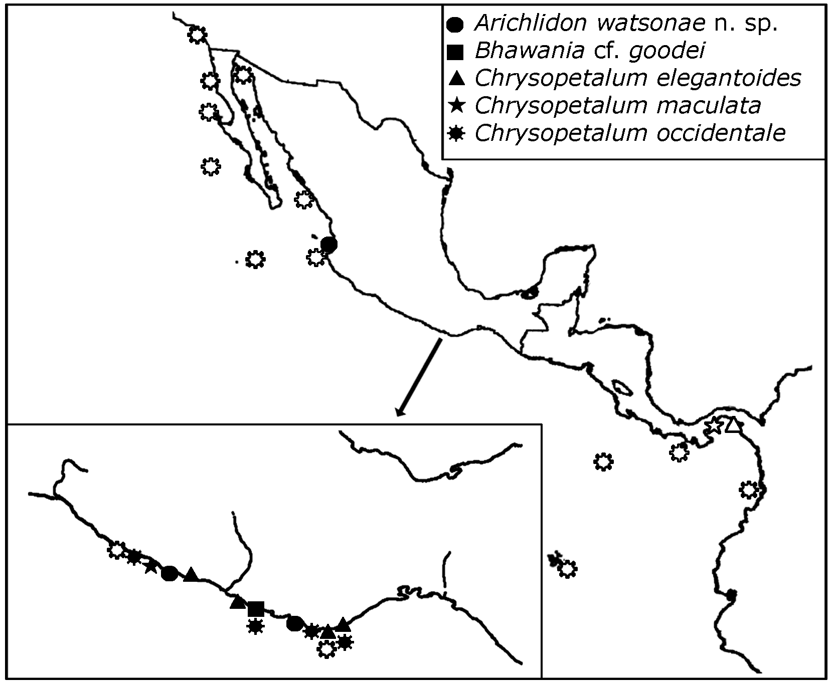
Distribution. Central Pacific of America, from Ixtapa, Guerrero, to Uvas Island, coast of Panama ( Aguado et al. 2003) ( Fig. 8 View FIGURE 8 ).
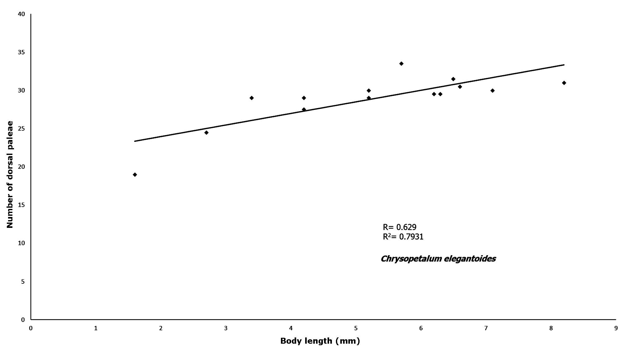
Remarks. Chrysopetalum elegantoides was described from the Pacific coast of Panama. The specimens from Oaxaca accord with the description by Aguado et al. (2003). Nevertheless, we noticed possible intraspecific differences in the number of dorsal paleae. For comparison purposes, 14 complete specimens of Chrysopetalum elegantoides Aguado, Capa & San Martín, 2003 , were measured: total length and total number of dorsal paleae from the 15th segment. An average was obtained from the number of paleae from the left and the right bundles, assuming that descriptions of chrysopetalids paleae are based on the number of paleae of these bundles. Through statistical analysis we confirmed that variability in the number of paleae is size related, showing a direct association of 79% (t cal = 4.51, t 0.05(12) = 1.79; p<0.05) ( Fig. 5 View FIGURE 5 ).
No known copyright restrictions apply. See Agosti, D., Egloff, W., 2009. Taxonomic information exchange and copyright: the Plazi approach. BMC Research Notes 2009, 2:53 for further explanation.
|
Kingdom |
|
|
Phylum |
|
|
Class |
|
|
Order |
|
|
Family |
|
|
SubFamily |
Chrysopetalinae |
|
Genus |
Chrysopetalum elegantoides Aguado, Capa & San Martín, 2003
| Cruz-Gómez, Christopher & Bastida-Zavala, J. Rolando 2018 |
Chrysopetalum elegantoides Aguado, Capa & San Martín, 2003
| Aguado, Capa & San Martin 2003 |