
Boreocanthon praticola (LeConte, 1859)
|
publication ID |
https://doi.org/ 10.5281/zenodo.7399212 |
|
publication LSID |
lsid:zoobank.org:pub:74CC7BA2-4E8D-4780-BB1B-E47370CBB19D |
|
DOI |
https://doi.org/10.5281/zenodo.7469719 |
|
persistent identifier |
https://treatment.plazi.org/id/B84F8792-9315-7F69-B1FC-B013FBCAB2D3 |
|
treatment provided by |
Felipe |
|
scientific name |
Boreocanthon praticola (LeConte, 1859) |
| status |
|
Boreocanthon praticola (LeConte, 1859) View in CoL , restored generic combination
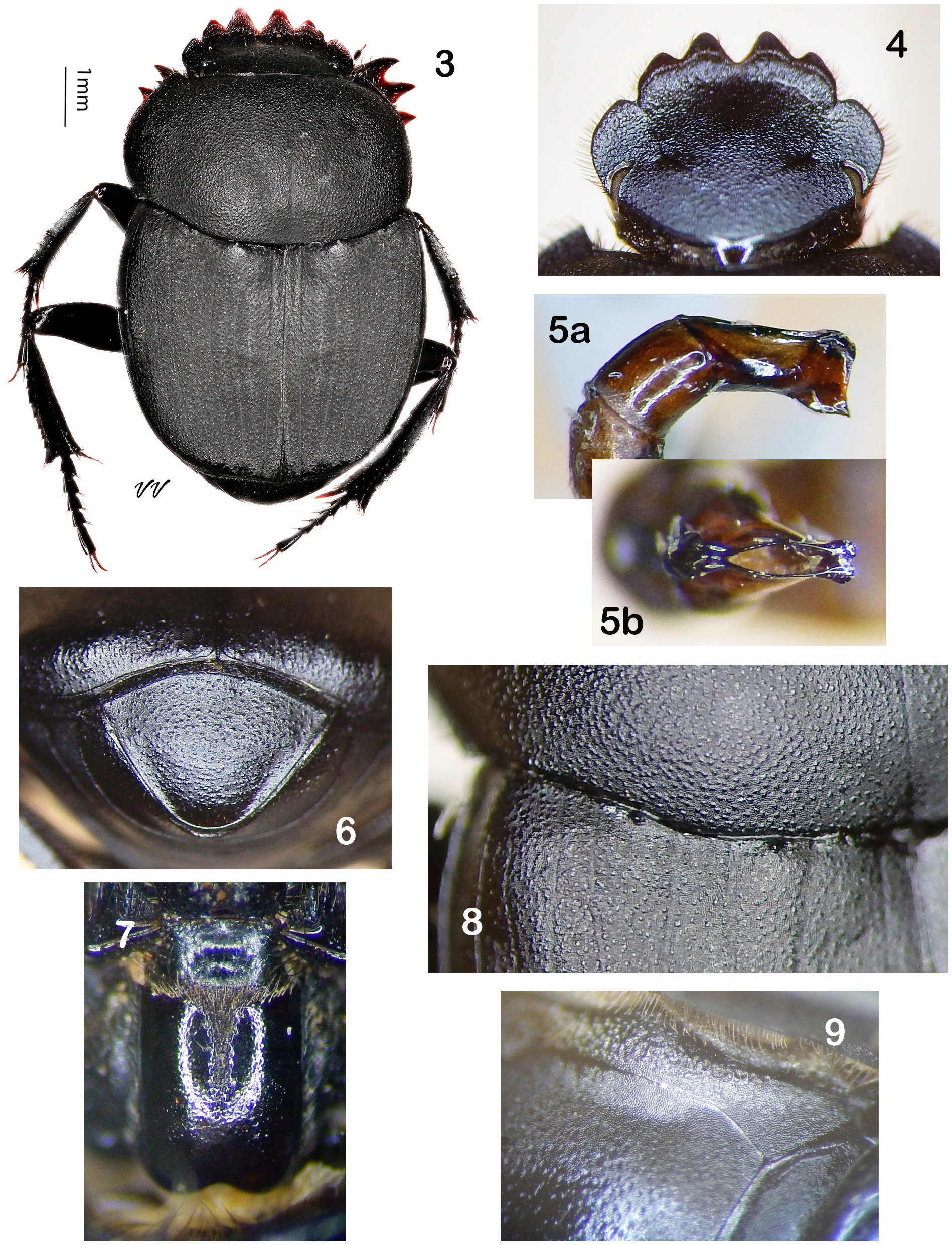
Fig. 3–10 View Figures 3–9 View Figure 10
Canthon praticola LeConte 1859c: 11 View in CoL .
Canthon praticola vetustus Pierce 1946: 122 View in CoL (new synonym per Miller et al. 1981: 626).
Boreocanthon praticola (LeConte) View in CoL (new combination per Halffter 1958: 210).
Canthon (Boreocanthon) praticola LeConte View in CoL (new combination per Howden 1966: 727).
Boreocanthon praticola (LeConte) View in CoL , restored generic combination.
Type material. 1) Canthon praticola LeConte : syntype (female). Museum of Comparative Zoology , Cambridge ( MCZ-ENT00003697 ). Examined by photograph (https://mczbase.mcz.harvard.edu/guid/ MCZ:Ent:3697); 2) Canthon praticola vetustus Pierce (sex undetermined): holotype (sex undetermined). Los Angeles County Museum of Natural History , LACMIP 2592. Not examined .
Type localities. 1) Canthon praticola LeConte : Kansas and New Mexico ; 2) Canthon praticola vetustus Pierce : Rancho La Brea , Tar Pit 81, Hancock Park, Los Angeles, California .
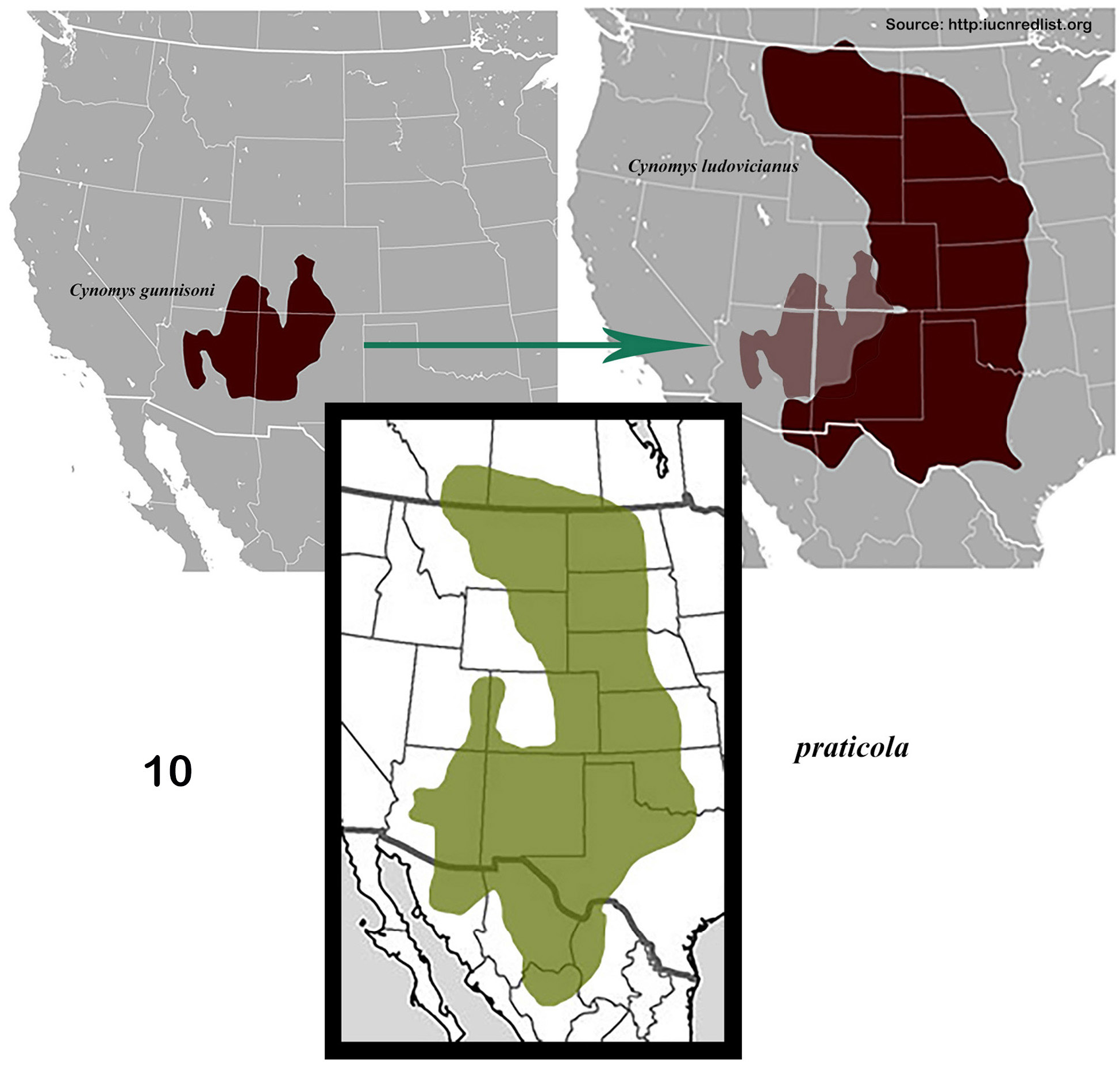
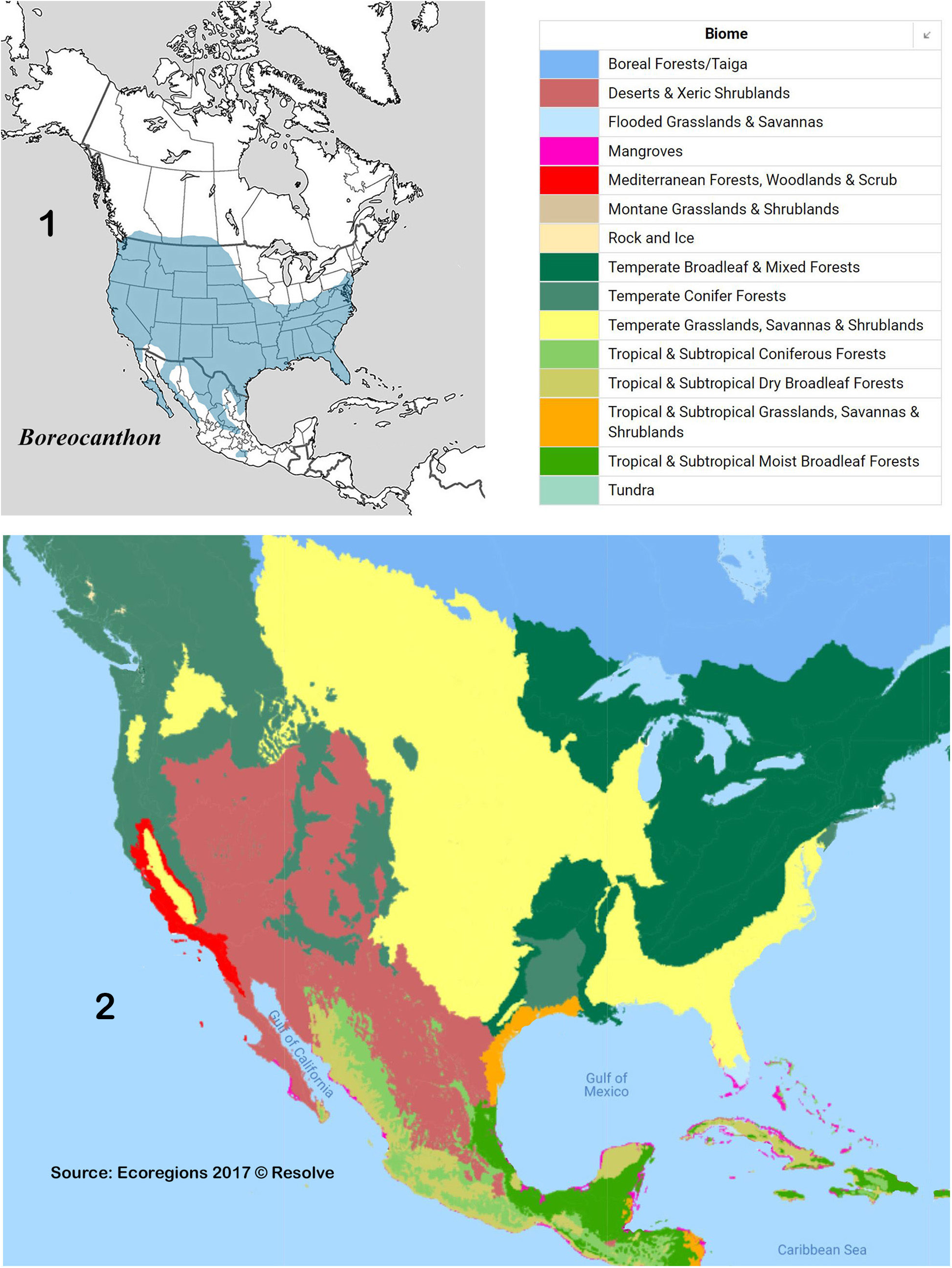
Diagnosis. Head: Granulorugose anteriorly, becoming distinctly granulate on vertex; granules small, surface evenly reflective ( Fig. 4 View Figures 3–9 ). Median pair clypeal teeth rounded, lateral teeth subangulate ( Fig. 4 View Figures 3–9 ). Paraocular notch conspicuous, acute, setting off angular projection of paraocular area, head appearing sexdentate ( Fig. 4 View Figures 3–9 ). Labio-gular fimbria ( Fig. 7 View Figures 3–9 ) gently curved posteriorly, interrupted medially by narrow, elongate field of coarse, setigerous punctures extending one-half length of gula. Prothorax: Pronotum ( Fig. 3, 8 View Figures 3–9 ) completely, evenly granulate on weakened shagreen background, granules irregularly shaped on disk, becoming rounded laterally. Anterior pronotal angles at most only weakly upturned, posterior portion of circumnotal ridge entire, not serrate. Hypomeral carina present, extending about one-fifth distance to lateral margin. Pterothorax: Mesoventrite ( Fig. 9 View Figures 3–9 ) rugose medially, smooth laterally. Metaventrite ( Fig. 9 View Figures 3–9 ) rather densely, sharply punctured. Elytra: Interstriae flat, shagreened, evenly granulate, granules uniformly rounded ( Fig. 8 View Figures 3–9 ). Striae superficial, lateral margins ill-defined; subhumeral (8 th) stria often very finely carinulate along lower margin, epipleural (9 th) stria rarely visible. Legs: Protibia evenly dilated, inner margin not offset. Protibial spurs sexually dimorphic (as in Fig. 116a, b View Figures 110–119 ). Metafemora lacking row of conspicuous setae along anterior margin. Abdomen: Pygidium ( Fig. 6 View Figures 3–9 ) weakly granulate, apex sometimes more conspicuously convex than base. Last (6 th) ventrite weakly granulate; other ventrites smooth medially. Genital capsule: Distal portion of parameres attenuated, truncate ( Fig. 5a View Figures 3–9 ); lower apical angle in form of elongate, rounded knob ( Fig. 5b View Figures 3–9 ). General: Dull black, no hint colorful undertones anywhere. Length: 4.5–8.5 mm. Geographic distribution ( Fig. 10 View Figure 10 ): Great Plains from Canada to Texas, extending westward into southern New Mexico and Arizona into northern Mexico. Ecogeographic environment ( Fig. 2 View Figures 1–2. 1 ): Temperate Grasslands, Savannas and Shrublands, and Deserts and Xeric Shrublands biomes. Specimens examined: 1750.
Collection localities.
CANADA — ALBERTA: Cypress County ( Mpal. Dist. ) ● Medicine Hat [Apr, Aug] ● Cypress Hills [Jun] ; Wheatland County ( Mpal. Dist. ) ● Cluny [Jun] ; Ranchland Mpal. Dist. ● 36 km SW Longview, 50.264° -114.264°, 1400 m [May] . MANITOBA: Mpal. Two Borders ● Lyleton .
MEXICO — CHIHUAHUA: Mpio. Cuauhtémoc ● 11 mi W Cuauhtémoc [Oct] ; Mpio. Huejotitán ● Valle de Olivos , 5500 ft [Jul] ; Mpio. Janos ● 20 km W Janos, 30°50 ʹ 33.8 ʺ N 108°23 ʹ 25.1 ʺ W [Oct] ● 80 mi NNW Casas Grandes [Aug] GoogleMaps ; ● 45 mi NW Casas Grandes [Aug] GoogleMaps ; Mpio. Juarez ● Samalayuca [Jun] ● Samalayuca, Laguna de Riataso [Aug] ; Mpio. López ● Salaices [Jul] ; Mpio. Matamoros ● Mariano Matamoros , 6000 ft [Aug] ; Mpio. Metachí ● Metachí [Aug] . DURANGO: Mpio. Diez de Octubre ● San Lucas , 6700 ft [Aug] ; Mpio. Lerdo ● Cd. Lerdo ; Mpio. Ocampo ● 173 mi N Durango [Aug] . SONORA: Mpio. Alamos ● Alamos [Jul] ● San Bernardo [Jul] ; Mpio. Cananea ● Cananea , 1525 m [Aug] ; Mpio. Hermosillo ● Hermosillo [Jul] ; Mpio. Naco ● Naco , 5000 ft [Aug] .
UNITED STATES — ARIZONA: Apache Co. ● 16–19 mi N St. Johns [Sep] ● Lyman Lake [Aug] ● 6 mi N St. Johns, 34.5858° N 109.3288° W, 1720 m [Aug]; Cochise Co. ● 2 mi SE Apache , 4400 ft [Aug] ● 8.5 mi S Apache [Aug] ● Douglas [Jun-Sep] ● 12 mi NE Douglas [Aug] ● 1 mi E Douglas [Aug] ● McNeal [Sep] ● Sycamore Canyon, Peloncillo Mountains [Jul] ● 8 mi E Portal [Jul, Sep] ● 1 mi NE Portal [Sep] ● 5 mi SW Portal, Southwest Research Station [Aug] ● Guadalupe Canyon [Jul] ● 2.3 mi WNW Chiricahua [Jul]; ● 22.5 and 36 mi SE Willcox [Jul]; ● 5.8 km SE Willcox, 32°13 ʹ 10 ʺ N 109°46 ʹ 51 ʺ W [Aug] ● Willcox Playa [Jul-Aug] ● Chiricahua Mountains, mouth of Pinery Canyon, 5300 ft [Jun-Aug] ● Palominas [Aug] ● Texas Canyon [Aug] ● Dos Cabezas [Aug] ● Kansas Settlement [Jul]; ● Hereford [Jul] ● Huachuca ● Skeleton Canyon [Aug] ● 10 mi NW Bisbee [Jul] ● Rustler Park [Aug]; Coconino Co. ● 4.5 mi E Moenkopi [Jun] ● Tuba City [Aug] ● 5 mi NE Cow Springs [Jul] ● Williams [Aug]; Gila Co. ● Pine ● Globe [Aug]; Graham Co. ● 65 mi N Willcox, Deer Creek Ranch, Galiuro Mts. [Jul]; Greenlee Co. ● 16 mi S Clifton [Aug] ● Franklin [Aug]; Maricopa Co. ● Webb [Jul] ● El Dorado [Jun]; Pima Co. ● Tucson [May, Aug] ● Boboquivari Mt. [Jul]; Santa Cruz Co. ● Patagonia [Aug-Sep] ● Sonoita [Jul] ● 4 mi S Sonoita [Jul]; ● 12 mi NE Sonoita [Jul, Sep]; ● 10 mi SE Patagonia; ● 3 and 10 mi E Patagonia [Aug]; ● Santa Cruz River , 2.5 mi E Lochiel, 4500 ft [Sep]; ● Madera Canyon ● Coronado National Forest, Parker Canyon at FM 61, 4800 ft [Sep] ● Elgin [Sep]; Yavapai Co. ● 17 mi W Jerome [Aug]; ● Seligman [Aug] ● Prescott Valley [Jul-Sep]; ● 2 mi W Dewey [Oct] ● 5 mi N Dewey [May] ● Hwy I-40, exit 103, Jolly Rd., 35°15.412 ʹ N 113°10.090 ʹ W, 5300 ft [May] ● Mayer [Aug]. COLORADO: Conejos Co. ● Antonito [Jun]; Denver Co. ● Denver [Jul]; El Paso Co. ● Colorado Springs [Jun, Oct]; Huerfano Co. ● Gardner [Jun]; Jefferson Co. ● Leyden [Aug]; La Plata Co. ● Durango [Jul]; Larimer Co. ● Ft. Collins [May]; Mesa Co. ● Mesa [Jul] ● 10 mi NW Mack [Apr]; Moffat Co. ● Craig, 6200 ft [Jun]; Morgan Co. ● Hwy 52, 6.3 mi N Fort Morgan [May]; Prowers Co. ● Lamar [Aug]; Weld Co. ● Greeley. KANSAS: Barber Co. ● 10.5 km W Hardtner, 37.02047 -98.76700 [Sep] ● 2mi W Hardtner [Nov]; Clark Co. ● (no data), 1962 ft [Jun]; Gove Co. (no data); Gray Co. (no Data); Hamilton Co. ● Syracuse [Jun]; Kiowa Co. ● 10 mi NW Mullinville [Jun] ● 13 mi S Greensburg [Jan-Feb, Apr, Jul]; Logan Co. (no data); Meade Co. ● Meade [Jul]; Morton Co. (no data); Norton Co. ● Prairie Dog State Park [May]; Reno Co. ● Medora [May]; Republic Co. ● Kakley [Jul]; Sheridan Co. (no data) Thomas Co. Colby [May]; Wallace Co. (no data) [Jul]. MONTANA: Beaverhead Co. ● Dillon [Apr-May] ● Bond [Aug] ● P&O Ranch [Aug] ● Blacktail Creek [Aug]; Big Horn Co. ● Lodge Grass [Jun]; Blaine Co. ● Chinook [Jul]; Cascade Co. ● Great Falls [May]; Chouteau Co. ● 15 mi S Loma [Jun]; Custer Co. ● 4 mi S Miles City [Aug]; Fergus Co. ● Suffolk [Jun]; Gallatin Co. ● Bozeman [May-Jul] ● 20 mi N Bozeman [Jun] ● Three Forks [Jul]; Glacier Co. ● Glacier National Park [Jul]; Jefferson Co. (no data) [Mar]; Judith Basin Co. ● Hobson [Aug]; Madison Co. (no data) [Jun]; Petroleum Co. 3 mi NW Winnett [Sep]; Teton Co. ● Bynum [Jul]; Yellowstone Co. ● Broadview [Jul]. NEBRASKA: Buffalo Co. ● 10 mi W Amherst, 40.859° N 99.380° W, 715 m Chase Co. ● Imperial [Jul]; Cheyenne Co. ● 3mi SE Lodgepole [Aug]; Dundy Co. ● Sanborn, 5 mi W Haigler, 40.06°W 102.02° W, 1010 m ● 4 mi E Haigler, 40°01 ʹ 25 ʺ N 101°51 ʹ 36 ʺ W, 285 m [Aug]; Frontier Co. ● Red Willow Reservoir State Wildlife Management Area, 40.40° N 100.68° W, 800 m [May]; Greeley Co. ● 7.3 mi S Greeley [Apr]; Keith Co. ● Lake McConaughy [May, Jul, Sep] ● 5mi S, 2 mi W Paxton [Jul]; Morrill Co. ● 8 mi W Bridgeport, 41.68° N 103.25° W, 1130 m [Jul]; 2.7 mi W Bridgeport [May]; Red Willow Co. ● McCook [May]; Sioux Co. ● 42°54 ʹ 59.88 ʺ N 103°45 ʹ 35.82 ʺ W, 1125 m Thomas Co. ● Nebraska National Forest, Whitetail Campground, 41.79413 -100.27381 [Sep]. NEW MEXICO: Bernalillo Co. ● Albuquerque [Aug]; Catron Co. ● Luna ; Chaves Co. ● Bottomless Lakes State Park [Jun]; Colfax Co. ● Maxwell [Jul] ● Koehler [Jul]; Doña Ana Co. ● Jornada Range [Jul] ● Isaack Lake [Jul]; Hidalgo Co. ● Lordsburg [Jul] ● 40 mi S Lordsburg [Jul] ● 1.5 mi NE Rodeo [Jul]; ● 39 mi SW Animas [Sep] ● Rodeo, 4000 ft [Jul-Aug] ● 34 mi S, 3 mi W Animas [Sep] ● 8 mi S Animas [Jul] ● 32 mi S Animas, Double Adobe Ranch, 5500 ft [Jul-Aug]; Luna Co. ● 7.5 mi W Akela Flats [Jul] ● Deming [Aug]; Roosevelt Co. ● 8 mi NE Portales, ENMU Natural History Preserve [Apr, Jul]; Sandoval Co. ● La Ventana, Jemez Mountains, 7200 ft [Jul]; San Juan Co. ● Aztec; Santa Fe Co. ● Santa Fe [May, Jul]; Socorro Co. ● 20 mi E Bernardo, 34°02.4 ʹ N 106° 36.49 ʹ W, 1607 m [Sep] ● Sevilleta National Wildlife Reserve [Aug]; Union Co. ● 8 mi N, 2.5 mi W Sofia (Kimble Ranch) [Sep] ● 10 mi S, 0.5 mi E Sofia (Britt Ranch) [Sep]. NORTH DAKOTA: Billings Co. ● South Unit, Theodore Roosevelt National Park [Apr]; Morton Co. (no data); Richland Co. (no data). OKLAHOMA: Comanche Co. ● Wichita Refuge [Aug]; Noble Co. ● (no data); Payne Co. ● (no data) [Aug]. SOUTH DAKOTA: Custer Co. ● Custer State Park [Jun]; Jackson Co. ● vicinity Badlands National Park [Jun]; Pennington Co. ● Hill City [Sep]; Perkins Co. ● Grand River National Grasslands [Aug]. TEXAS: Brewster Co. ● Alpine [Jun] ● 7 mi NW Alpine [Jun] ● Marathon [Jun]; Callahan Co. ● Baird [Jun]; Culberson Co. (no data); Dallam Co. ● Perico [Aug]; Dallas Co. ● Dallas; Dawson Co. ● Lamesa [May]; Jeff Davis Co. ● Ft. Davis [Jul-Aug] ● Valentine [Jun]; ● 8 mi SE Valentine [Jul] ● 16 km S Fort Davis (along TX 17), 30°27 ʹ 48 ʺ N 103°58 ʹ 59 ʺ W, 1600 m (Aug); ● ~ 16 km NE Valentine, Muerto Springs Ranch (Muerto Springs), 30°40 ʹ 50 ʺ N 104°20 ʹ 22 ʺ W, 1555 m (Jul); ● ~ 16 km NE Valentine, Muerto Springs Ranch (Muerto Springs, near headquarters), 30°40 ʹ 28 ʺ N 104°24 ʹ 07 ʺ W, 1475 m (Jul); Lubbock Co. ● Lubbock [Aug] ● Ransom Canyon [Sep]; Presidio Co. ● Marfa [Jun] ● 37 km SSW Marfa (along FM 2810, Petan Ranch – Cherry Hills sector), 30°07 ʹ 35 ʺ N 104°19 ʹ 24 ʺ W, 1630 m (Jun); ● 20–26 km SSE Marfa (along FM 169), 1355–1415 m (Jun); ● 8 km W La Viuda Peak, 29°42 ʹ 30 ʺ N 103°54 ʹ 30 ʺ, 1200 m (Sep) ● ~ 16 km W Valentine (Miller Ranch, near headquarters), 30°33°30 ʺ N 104°38 ʹ 44 ʺ W, 1350 m (Jul–Aug); ● ~ 6.5 km W Marfa (Hip-O Ranch), 30°21 ʹ 54 ʺ N 104°07 ʹ 12 ʺ W, 1530 m (AugSep) ● 4 mi SE Presidio [Jul]; Reeves Co. ● Toyah [Jun]; Wichita Co. ● Foster Ranch [Aug]; Wilbarger Co. ● Vernon [Aug]. UTAH: Duchesne Co. ● Monument Butte, near Myton [Jul]; San Juan Co. ● Blanding [Jul] ● 9.7 mi ENE Monticello, 2063 m [May]. WYOMING: Albany Co. ● Laramie [Jun]; Crook Co. ● 4 mi N Sundance [Jun] ● Devil’s Tower National Monument [Jun]; Laramie Co. ● Cheyenne [Jul]; Sheridan Co. ● 25mi E Sheridan [Jun].
Comments. Boreocanthon praticola is a very common, widespread species often confused with B. ebenus , from which it is easily distinguished by its convex (not impressed basally) pygidium and sexually dimorphic protibial spurs. The two are widely sympatric where cool (elevations> 1200 m south,> 800 m north) grasslands are punctuated by enclaves of vegetated sand habitat. Because it conserves a macrogranulated sculpture as well as dimorphic protibial spurs, I regard it a taxonomic isolate and annectant between B. ebenus - B. depressipennis (granulate dorsum) and rest of genus (sexually dimorphic protibial spurs). Boreocanthon praticola is subject to a considerable amount of variation, especially in size and surface texture — smaller individuals are routinely more finely granulose and require close inspection (10×). Populations from northern portions of its range (Nebraska north and northwestward) tend to be smaller and with finer dorsal granulation. I have examined specimens labeled Brazoria Co., Texas, and Benton Co, Arkansas; I consider them records that require corroboration.
Pierce’s (1946) fossil taxon, Canthon praticola vetustus (along with B. simplex , q.v.) was collected from substrate drawn from Pit 81 of the Rancho La Brea Tar Pits in Los Angeles, California, excavated in 1915 ( Miller et al. 1981; Miller 1986); co-occurring Equus remains were later dated ca. 11,000 years BP (Miller 1986). Pierce’s decision to place it near B. praticola is clearly reasonable inasmuch as the holotype (an elytron) is of the proper size (4.5 mm) and exhibits the dual granulation one would expect of this species. Moreover, while it does not presently occur west of Arizona, the presence of B. praticola at La Brea from the Pleistocene/Holocene boundary (ca. 11,000 years BP) is a reasonable assumption. The scarabaeine fauna at that time included at least Canthon , Copris , Onthophagus and Phanaeus ( Pierce 1946, Miller 1983, Edmonds 1994). At the time, when the biotic landscape was quite different than now, the scarabaeine fauna of southern California was evidently very similar to the modern fauna of southern Arizona.
Ample evidence suggests that B. praticola maintains a strongly preferential association with prairie dogs. Indeed, its US distribution corresponds rather closely to the combined ranges of Gunnison’s Prairie Dog, Cynomys gunnisoni (Baird, 1855) and the more widespread Black-Tailed Prairie Dog, C. ludovicianus (Ord, 1815) ( Fig. 10 View Figure 10 ). Field studies by Gordon and Cartwright (1974) in North Dakota and Colorado revealed that these beetles are commonly found in mounds surrounding burrow entrances where dung pellets were plentiful; they observed no activity in nearby bison droppings. James Saulnier (pers. comm.) has collected specimens in large numbers from active prairie dog colonies in northern Yavapai Co., Arizona. Floate and Gill (1998) found B. praticola to be a rare member of the cattle dung beetle community in southern Alberta, Canada, a coprofauna overwhelmingly dominated by aphodiines. Other than prairie dog droppings, B. praticola has been recorded from cattle feces as well as that of pig, bison, humans and rabbits. Edmonds (2018) reported B. praticola from open grasslands of the Big Bend region of west Texas, where it is commonly collected on cattle and human feces. McNamara (2013) recorded B. praticola from four Canadian provinces: Alberta, Saskatchewan, Manitoba and British Columbia; the latter, while not out of the question, needs confirmation.
In addition to the syntype cited above, there is another probable syntype also present in the LeConte Collection at the Museum of Comparative Zoology, Harvard University (Crystal Maier, pers. comm).
No known copyright restrictions apply. See Agosti, D., Egloff, W., 2009. Taxonomic information exchange and copyright: the Plazi approach. BMC Research Notes 2009, 2:53 for further explanation.
|
Kingdom |
|
|
Phylum |
|
|
Class |
|
|
Order |
|
|
Family |
|
|
SubFamily |
Scarabaeinae |
|
Tribe |
Deltochilini |
|
Genus |
Boreocanthon praticola (LeConte, 1859)
| Edmonds, W. D. 2022 |
Canthon (Boreocanthon) praticola
| Howden HF 1966: 727 |
Boreocanthon praticola (LeConte)
| Halffter G. 1958: 210 |
Canthon praticola vetustus
| Miller SE & Gordon RD & Howden HF 1981: 626 |
| Pierce WD 1946: 122 |
Canthon praticola
| LeConte JL 1859: 11 |