
Abrahamia suarezensis Randrian. & Lowry, 2017
|
publication ID |
https://doi.org/ 10.5281/zenodo.7618113 |
|
DOI |
https://doi.org/10.5281/zenodo.7618434 |
|
persistent identifier |
https://treatment.plazi.org/id/038887C6-FF4A-FF51-FE43-83651AB50DD6 |
|
treatment provided by |
Carolina |
|
scientific name |
Abrahamia suarezensis Randrian. & Lowry |
| status |
sp. nov. |
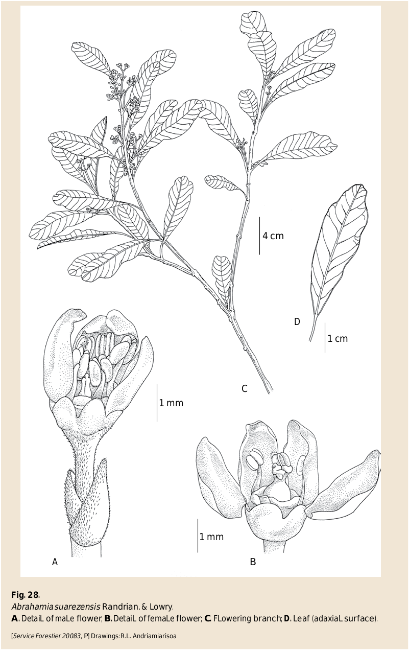
31. Abrahamia suarezensis Randrian. & Lowry View in CoL View at ENA , spec. nova ( Fig. 28-29 View Fig View Fig ).
Typus : MADAGASCAR. Prov. Antsiranana: Rég. Diana , NW, près de Ramena, 12°14’S 49°21’E, 9.XI.1961, Service Forestier 20083 (holo-: P [ P06169101 ]!; GoogleMaps iso-: G!, MO- 6684137 !, NY!, P [ P00722667 ]!, TEF [ TEF000887 View Materials ]!). GoogleMaps
Diagnosis
Abrahamia suarezensis Randrian. & Lowry can easily be distinguished from other members of the genus by its small, narrow oblanceolate leaves (2.5-6.5 3 0.7-2.5 cm) with ascending secondary veins that form an acute angle with the midvein at the leaf base.
Description
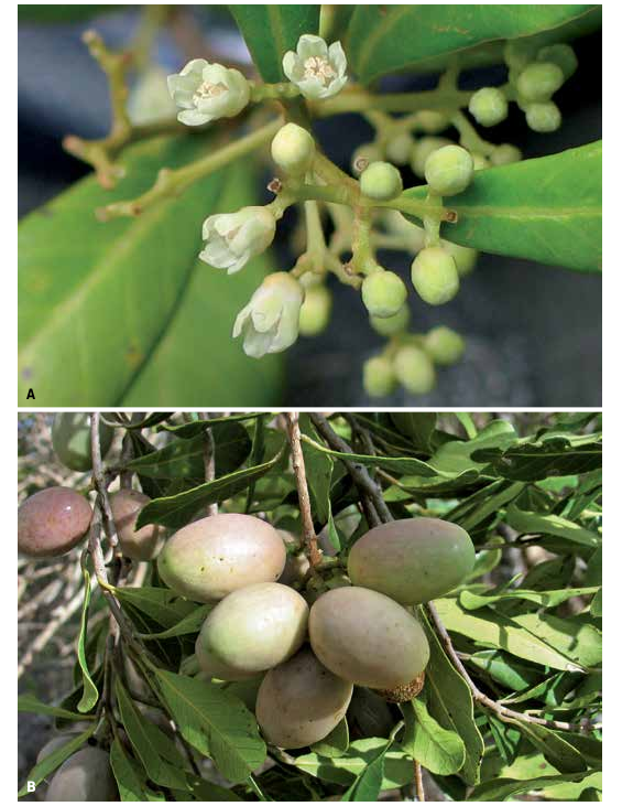
Shrubs or trees 1.5-20 m tall, 6-40 cm DBH; young twigs waxy, lenticellate and pubescent at the very tip. Leaves opposite to subopposite; blades oblanceolate to obovate, 2.5-7.5 3 0.7-3.5 cm, subcoriaceous to chartaceous, apex rounded, retuse, or emarginate, margin entire, undulate, base acute to cuneate, adaxial surface glabrous, abaxial surface with sparse sericeous indument when young, glabrescent, venation craspedodromous, midvein slightly prominent abaxially, secondary veins 9-12 pairs, 1-5 mm apart, not very prominent abaxially but well defined, tertiary veins obscure on both surfaces; petiole 4-10 mm long, canaliculate on adaxial surface, sericeous when young, glabrescent. Inflorescence axillary or terminal, a panicle (sometimes depauperate), 1.5-3.5 cm long, the axes flattened, sericeous. Male and female flowers with a pedicel 0.5-1 mm long, pubescent; calyx lobes very widely ovate, c. 1 3 1 mm, glabrous on both surface; corolla lobes ovate, 2.5-3 3 2 mm, imbricate, glabrous on both surfaces, yellow green or light yellow; stamens 4 or 5. Male flowers 5-merous, filaments 1.5-2 mm long, glabrous, white, anthers 1 mm long, obloid to slightly ovoid, yellow, glabrous; disk 1 mm in diam., glabrous; ovary rudimentary. Female flowers 4-merous, filaments c. 1.5 mm long, glabrous, white, anthers c. 0.8 mm long, ovoid, sterile, yellow, glabrous; disk annular, cupuliform, c. 1.5 mm in diam., glabrous; ovary very widely ovoid, 1 3 1 mm, glabrous, placentation apical or slightly subapical; style shortly trifid, latero-subapical or apical, 0.7-0.8 mm long, glabrous, stigmas capitate. Fruits 1.8-2.7 3 1-1.5 cm, ellipsoid, slightly asymmetrical, glabrous, with longitudinal striations.
Distribution, ecology and phenology
Abrahamia suarezensis is known only from far northern and northeastern Madagascar, from the vicinity of Antsiranana to the area around Daraina and extending along the east coast to S of Vohémar ( Map 8 View Map 8 ). It appears to occur primarily in coastal sandy dune forests although several collections have been made in dry forest on other substrates in the Daraina area (i.e., to the W of Vohémar). Flowering material has been collected in October and November, and fruits are known from November and December.
Photos:R. Randrianaivo
Conservation status
With an EOO of 9,014 km 2, a minimum AOO of 116 km 2, and 35 recorded localities, with subpopulations in 3 protected areas (Loky Manambato, Oronjia, and Montagne des Français), representing c. 23 locations, A. suarezensis is assigned a preliminary conservation status of “Least Concern’’ [LC] using the IUCN Red List Categories and Criteria ( IUCN, 2012).
Notes
Abrahamia suarezensis most closely resembles A. patrickii , from which it differs by having leaves with fewer secondary veins (9-12 vs 24-28) that are widely (vs closely) spaced, and shorter petioles (4-10 vs 6-13 mm).
Typical material of this species from dunes in the area around Antsiranana has narrowly obovate to oblanceolate leaves up to 5 cm long, but collections from farther South near Daraina and Mahavanona have more broadly obovate leaves that can reach 5-7 cm in length, as well as slightly larger fruits. While these differences appear to show some geographic structuring, we have chosen to refrain from recognizing the larger-leaved material from the South as a distinct taxon because no clear limits can be seen between the forms and certain specimens bear leaves spanning the range of variation in both shape and size.
Paratypi
MADAGASCAR. Prov. Antsiranana: Vohémar, Ampisikina , Misoribe , 12°58’10’’S 49°34’58’’E, 179 m, 28.IX.2013, fl., Bernard 2170 ( MO, P, TAN) GoogleMaps ; Antsiranana II, Ramena, Orangea, Mamelon vert, 12°14’38’’S 49°22’04’’E, 39 m, 17.XII.2008, fr., Claude Christian et al. 14 ( MO, P, TAN) GoogleMaps ; Antsiranana, Ramena, forêt d’Orangea , 12°15’S 49°23’30’’E, 24.I.2002, fr., De Block et al. 1378 ( BR, G, K, MO, P, TAN) GoogleMaps ; Vohémar, Daraina, forêt d’Ambohitsitondroina , 13°08’S 49°27’E, 180 m, 20.III.2004, fr., Gautier et al. 4655 ( G, MO, TAN) GoogleMaps ; Vohémar, Ampasiramena , 12°50’34’’S 49°49’44’’E, 7 m, 12.XI.2005, fl., Jullet Be et al. 260 ( CNARP, MO, P, TAN) GoogleMaps ; Daraina, Ambilondambo , 13°09’55’’S 49°38’52’’E, 292 m, 17.XI.2005, fl., Jullet Be et al. 294 ( CNARP, MO, P, TAN) GoogleMaps ; Nosibe, forêt d’Analabe, Andavakabe , 13°03’49’’S 49°54’02’’E, 25 m, 4.XII.2004, y. fr., Manjakahery et al. 58 ( MO, P, TAN) GoogleMaps ; ibid. loco, 13°04’06’’S 49°54’24’’E, 29 m, 8.XII.2004, y. fr., Manjakahery et al. 76 ( MO, P, TAN) GoogleMaps ; ibid. loco, 13°04’20’’S 49°54’04’’E, 18 m, 15.XII.2004, y. fr., Manjakahery et al. 94 ( MO, P, TAN) GoogleMaps ; Sakalava Bay , 12°14’S 49°22’E, 20 m, 26.XI.1989, fl., McPherson 14563 ( MO, P, TAN) GoogleMaps ; Antsahalalina , 12 km E of Daraina, 14°07’S 49°46’E, 205-607 m, 24.II.1990, fr., Meyers 45 ( MO, P, TAN) GoogleMaps ; Analamazava , SW of Daraina, [14°73’S 49°38’E], 200-1180 m, 23.III.1990, ster., Meyers 73 ( MO, TAN) GoogleMaps ; ibid. loco, 26.IV.1990, ster., Meyers 93 ( MO, P, TAN) ; ibid. loco, 24.XI.1990, fl., Meyers 204 ( MO, P, TAN) ; ibid. loco, 19.II.1991, fr., Meyers 273 ( P, MO, TAN) ; Manatamena , 7 km NE of Daraina, 14°60’S 49°42’E, 112-330 m, IV.1990, ster., Meyers et al. 106 ( MO, P, TAN) GoogleMaps ; Daraina, forêt d’Ampondrabe, 12°58’S 49°42’E, 199 m, 15.II.2005, fr., Nusbaumer et al. 1474 ( G, MO, TAN) GoogleMaps ; Daraina, forêt d’Ambohitsitondroina, 13°08’S 49°27’E, 272 m, 20.I.2006, fr., Nusbaumer et al. 1966 ( G, MO, TAN) GoogleMaps ; Ramena , forêt de l’Orangea, 12°15’13’’S 49°21’44’’E, 13-25 m, 3.IX.2001, fl., Rabenantoandro et al. 627 ( MO, P, TAN) GoogleMaps ; forêt d’Anaborano, près du Lac Sahaka , 13°04’42’’S 49°54’13’’E, 25 m, 2.XI.2002, fl., Rabenantoandro et al. 1095 ( G, K, MO, P, TAN, TEF) GoogleMaps ; Tsarabaria , forêt d’Ambondrobe, 13°43’05’’S 50°05’’52’’E, 13 m, 3.III.2003, fr., Rabenantoandro et al. 1412 ( G, MO, P, TEF); GoogleMaps Daraina , E du village d’Ambondrombe, 13°41’48’’S 50°05’18’’E, 14.III.2004, fr., Rabevohitra et al. 5149 ( G, K, MO, P, TEF [2 sheets]); GoogleMaps forêt d’Orangea, 12°15’S 49°20’E, 3.X.2006, fl., Rakotonandrasana et al. 1026 ( CNARP, MO, P, TAN); GoogleMaps Ambolobozobe , Ambovomavo, 12°31’13’’S 49°31’21’’E, 24.XI.2007, fr., Rakotonandrasana et al. 1208 ( CNARP, G, MO, P, TAN); GoogleMaps Mahavanona , forêt d’ Analabe, 12°24’46’’S 49°22’25’’E, 219 m, 15.II.2005, fr., Rakotondrafara 295 ( CNARP, G, MO, P, TAN); GoogleMaps Andrafiabe , Anjialava, 12°26’57’’S 49°30’48’’E, 2 m, 13.XII.2007, fr., Rakotondrafara et al. 519 ( CNARP, G, MO, P, TAN); GoogleMaps forêt E de Diego-Suarez, [12°16’55’’S 49°17’40’’E], X.1975, fl., Rakotozafy 1529 ( MO, TAN); GoogleMaps Baie de Sakalava , 12°16’39’’S 49°22’49’’E, 21 m, 5.XI.2006, fl., Ranaivojaona 1480 ( G, MO, P, TAN); GoogleMaps Orangea , 12°14’12’’S 49°22’08’’E, 33 m, 7.XI.2006, fr., Ranaivojaona 1571 ( G, MO, P, TAN); GoogleMaps Ankorangana , forêt d’Andramadana, 12°39’18’’S 49°32’11’’E, 15 m, 22.XI.2001, fr., Randrianaivo et al. 803 ( MO, P, TAN); GoogleMaps forêt d’Orangea, 12°15’01’’S 49°21’40’’E, 76 m, 8.XII.2004, fr., Randrianaivo et al. 1131 ( G, MO, P, TAN); GoogleMaps Daraina , forêt de Bakaraoka Sud, 13°11’13’’S 49°42’40’’E, 191 m, 15.XI.2005, fl., S. Randrianasolo et al. 551 ( CNARP, MO, P, TAN); GoogleMaps Daraina , forêt d’Ambilondomba, [13°10’S 49°39’E], 471 m, 27.I.2004, fr., Ranirison et al. 326 ( G, MO, TAN); GoogleMaps Daraina , Befarafara, Solanampilaka, 13°05’56’’S 49°35’29’’E, 110 m, 16.XI.2005, fl., Ratovoson et al. 1109 ( CNARP, G, MO, P, TAN); GoogleMaps fourrée d’Orangea , 12°16’59’’S 49°23’03’’E, 46 m, 30.XI.2005, fl., Razafitsalama et al. 868 ( CNARP, G, MO, P, TAN); GoogleMaps Vohémar , Tsarabaria, forêt E du village Ambondrombe, 13°43’08’’S 50°05’50’’E, 13.III.2004, fl., Razakamalala et al. 1006 ( G, K, MO, P, TAN); GoogleMaps Near village of Ankorikakely, 2-3 km NE Sakalava bay, 12°16’40’’S 49°23’05’’E, 48 m, 4.XI.2006, fr., Rogers et al. 1089 ( MO, P, TAN); GoogleMaps Orangea , Ramena, 12°14’13’’S 49°22’08’’E, 10 m, 12.II.2005, fr., Schatz et al. 4190 ( MO, P, TAN); GoogleMaps Vohémar , 27.XII.1951, ster., Service Forestier 4348 ( P); GoogleMaps forêt d’Andranotsimaka, [12°23’00’’S 49°07’40’’E], 4.X.1952, fl. & fr., Service Forestier 5788 ( MO, P, TEF); GoogleMaps forêt d’Orangea, [12°16’55’’S 49°17’40’’E], 18.X.1954, fl., Service Forestier 11337 ( G, MO, NY, P [2 sheets], TEF); GoogleMaps Analabe, Vohémar , [14°03’S 49°43’E], 13.IX.1955, fl., Service Forestier 15498 ( G, MO, NY, P, TEF); GoogleMaps dunes littorales, près de Ramena , [12°14’S 49°21’E], 9.XI.1961, fl., Service Forestier 20368 ( G, K, MO, MY, P [2 sheets], TEF); GoogleMaps ibid. loco, Service Forestier 20369 ( MO, P, TEF); forêt littorale, S de Vohémar , [13°21’S 50°00’E], 11-19.XII.1966, bud & fl., Service Forestier 27279 ( MO, P, TEF); GoogleMaps ibid. loco, fr., Service Forestier 27280 ( P); GoogleMaps versant E du massif de l’Ankerana, N de Vohémar, [13°17’S 49°51’E], 50-450 m, 17.XII.1966, fl., Service Forestier 27352 ( P, TEF); GoogleMaps forêt d’Orangea area, 12°14’S 49°21’E, 55 m, 23.X.1993, fl., van Nek 1978 ( TAN); GoogleMaps ibid. loco, 12°14’S 49°22’E, 65 m, 23.X.1993, fl., van Nek 1984 ( G, MO, P, TAN). GoogleMaps

| TEF |
TEF |
| CNARP |
CNARP |
| P |
Museum National d' Histoire Naturelle, Paris (MNHN) - Vascular Plants |
| G |
Conservatoire et Jardin botaniques de la Ville de Genève |
| NY |
William and Lynda Steere Herbarium of the New York Botanical Garden |
| TEF |
Centre National de la Recherche Appliquée au Developement Rural |
| MO |
Missouri Botanical Garden |
| TAN |
Parc de Tsimbazaza |
| BR |
Embrapa Agrobiology Diazothrophic Microbial Culture Collection |
| K |
Royal Botanic Gardens |
| MY |
Universidad Central de Venezuela |
No known copyright restrictions apply. See Agosti, D., Egloff, W., 2009. Taxonomic information exchange and copyright: the Plazi approach. BMC Research Notes 2009, 2:53 for further explanation.
|
Kingdom |
|
|
Phylum |
|
|
Class |
|
|
Order |
|
|
Family |
|
|
Genus |