
Desognaphosa spurgeon, PLATNICK, 2002
|
publication ID |
https://doi.org/ 10.1206/0003-0090(2002)271<0001:AROTAG>2.0.CO;2 |
|
persistent identifier |
https://treatment.plazi.org/id/03EAE52A-FFC4-A63B-8256-24CADF5C4919 |
|
treatment provided by |
Felipe |
|
scientific name |
Desognaphosa spurgeon |
| status |
sp. nov. |
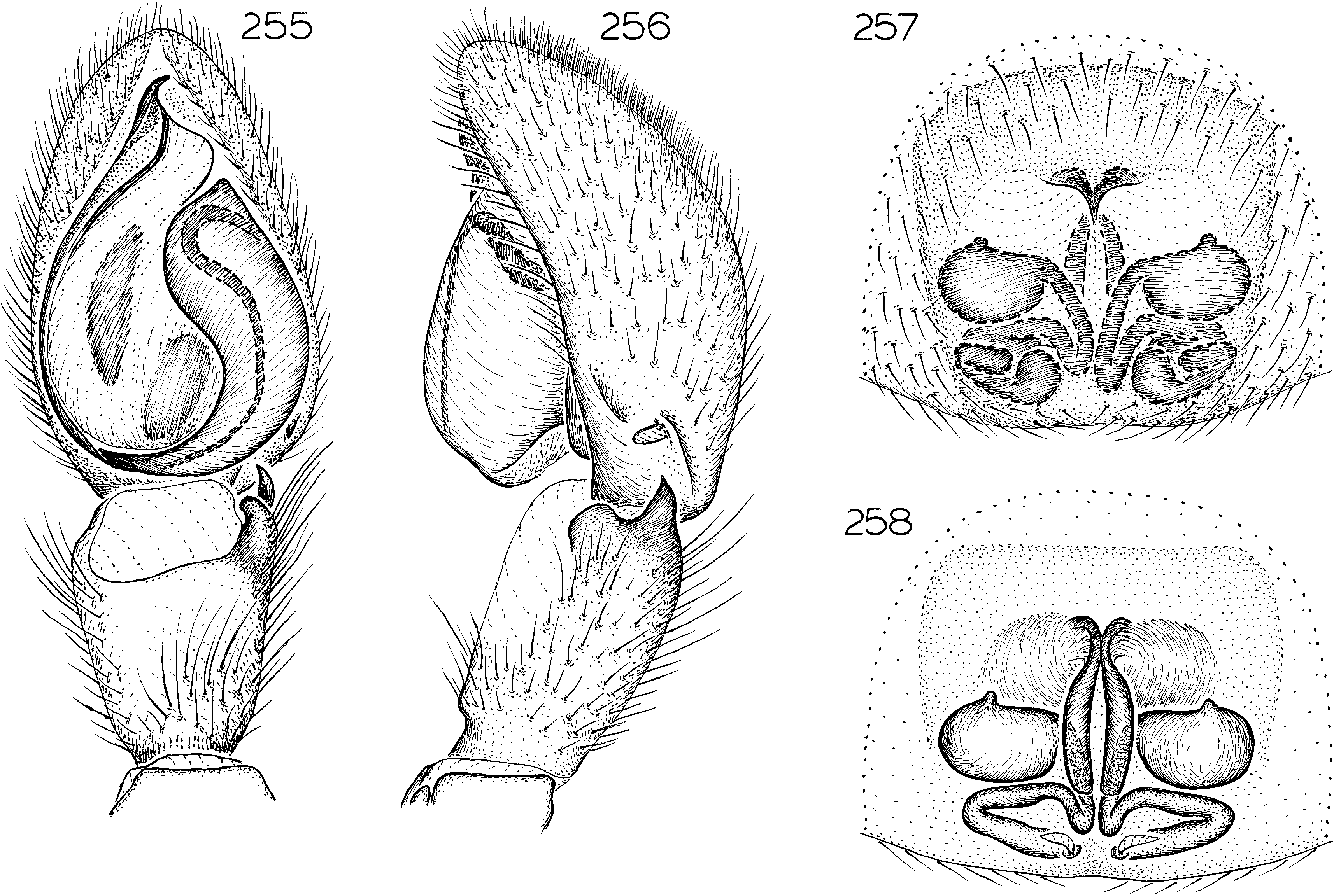
Desognaphosa spurgeon , new species Figures 255–258 View Figs ; Map 23 View Map 23
TYPES: Female holotype, male allotype, and male paratype taken in pitfall traps in open forest at an elevation of 1080 m on Mount Spurgeon , 16 ° 27 ̍ S, 145 ° 11 ̍ E, Queensland (Nov. 19, 1997 – Feb. 8, 1998; G. Monteith, D. Cook), deposited in QMB ( S43899 View Materials ) .
ETYMOLOGY: The specific name is a noun in apposition taken from the type locality.
DIAGNOSIS: Males can easily be recognized by the basally widened terminal elements of the palpal bulb (fig. 255), females by the pair of anteromedian epigynal hoods (fig. 257).
MALE: Total length 4.8. Coloration as in D. bulburin . Leg spination: tibiae: IV v22 2, r011; metatarsi: III v202; IV p010, v222, r110. Retrolateral tibial apophysis short, triangular, paracymbial apophysis short (fig. 256); embolus short, twisted terminal elements of bulb basally widened, basal portion translucent (fig. 255)
FEMALE: Total length 6.1. Coloration as in male. Leg spination: tibiae: III v21p2; IV v222, r011; metatarsi: III v202; IV p0 10, v222, r110. Margins of epigynal atri um indistinct except at pair of paramedian anterior hoods (fig. 257); median ducts extended longitudinally to height of epigynal hoods (fig. 258).
OTHER MATERIAL EXAMINED: Queensland: Bakers Blue Mountain , 17 km W Mount Molloy, 16 ° 42 ̍ S, 145 ° 10 ̍ E, Jan. 1–18, 1990, pitfalls, elev. 900–1100 m ( QMB S16731 View Materials , 28758 View Materials , 28768 View Materials ), 33 ; Black Mountain , 17 km ESE Julatten, 16 ° 39 ̍ S, 145 ° 29 ̍ E, Apr. 29– 30, 1982, rainforest, elev. 800–1000 m (G. Monteith, D. Yeates, D. Cook, QMB S26689 View Materials ), 1♀ ; Black Mountain , lower slopes, 16 ° 40 ̍ S, 145 ° 30 ̍ E, Dec. 2, 1997 – Feb. 6, 1998, rainforest pitfall, intercept trap, elev. 530 m (G. Monteith, D. Cook, QMB S43881 View Materials , 43895 View Materials ), 13, 1♀ ; Black Mountain Road, 28.1 km NW by road of Kuranda , 16 ° 40 ̍ S, 145 ° 30 ̍ E, Apr. 28, 1998, rainforest (G. Milledge, AMS KS55298 ), 1♀ ; Lambs Head , 10 km W Edmonton, 17 ° 02 ̍ S, 145 ° 38 ̍ E, Dec. 10–12, 1989, elev. 1200 m (G. Monteith, G. Thompson, H. Janetzki, QMB S28760 View Materials ), 1♀ ; Mossman Bluff, 5–10 km W Mossman, 16 ° 28 ̍ S, 145 ° 22 ̍ E, Dec. 18, 1988, pyrethrum knockdown, trees, rocks, elev. 1300 m (G. Monteith, G. Thompson, QMB S28732 View Materials ), 13, Jan. 1–17, 1989, pitfall, elev. 1180 m (G. Monteith, G. Thompson, QMB S27725 View Materials ), 1♀, Dec. 21, 1989, elev. 1300 m (G. Monteith, G. Thompson, QMB S28733 View Materials ), 1♀ ; summit, Mount Demi , 16 ° 30 ̍ S, 145 ° 19 ̍ E, Dec. 17, 1995 – Jan. 25, 1996, pitfalls, elev. 1100 m (G. Monteith, G. Thompson, Ford,. QMB S34548 View Materials ), 2♀ ; 7.5 km N Mount Lewis, via Julatten , 16 ° 34 ̍ S, 145 ° 16 ̍ E, Sept. 8, 1991, rainforest, elev. 1200 m (G. Monteith, D. Cook, QMB S26661 View Materials ), 13 ; 18 km N Mount Lewis , 16 ° 30 ̍ S, 145 ° 16 ̍ E, Nov. 23, 1998, Berlese, rainforest moss, litter, elev. 1300 m (G. Monteith, QMB S47787 View Materials ), 1♀ ; Mount Spurgeon , summit, 16 ° 26 ̍ S, 145 ° 11 ̍ E, Nov. 22, 1997, Berlese, sieved rainforest litter, elev. 1300 m (G. Monteith, QMB), 13 ; Mount Spurgeon , 16 ° 27 ̍ S, 145 ° 11 ̍ E, Nov. 19, 1997 – Feb. 8, 1998, pitfalls, open forest, elev. 1080–1100 m (G. Monteith, D. Cook, QMB S43899 View Materials , 43941 View Materials ), 33, 1♀ ; Mount Spurgeon , 16 ° 28 ̍ S, 145 ° 12 ̍ E, Nov. 20, 1997 – Feb. 8, 1998, pitfalls, intercept trap, open forest, elev. 1140 m (G. Monteith, D. Cook, QMB S43897 View Materials , 44766 View Materials ), 23, 1♀ ; summit, Mount Williams , 16 ° 55 ̍ S, 145 ° 40 ̍ E, Dec. 2– 3, 1993, elev. 900–1000 m (D. Cook, G. Monteith, H. Janetzki, QMB S28736 View Materials ), 13, 1♀, Nov. 27, 1997 – Feb. 6, 1998, rainforest pitfall, elev. 1000 m (G. Monteith, D. Cook, QMB S43909 View Materials ), 1♀, Nov. 28, 1997, Berlese, rainforest moss on trees, elev. 1000 m (G. Monteith, QMB S43893 View Materials ), 1♀ ; head, Roots Creek , 12 km WNW Mossman, 16 ° 27 ̍ S, 145 ° 23 ̍ E, Dec. 28, 1989 – Jan. 11, 1990, pitfall, elev. 1200 m ( QMB S28719 View Materials ), 13 ; Sandy Creek, Mount Spurgeon , 16 ° 28 ̍ S, 145 ° 12 ̍ E, Nov. 20–22, 1997, dung trap, elev. 1100 m (G. Monteith, QMB S43900 View Materials ), 13 ; Stewart Creek , 4 km NNE Mount Spurgeon, 16 ° 24 ̍ S, 145 ° 13 ̍ E, Oct. 15–20, 1991, elev. 1250–1300 m (G. Monteith, H. Janetzki, D. Cook, Roberts, QMB S28765 View Materials ), 1♀ ; Windsor Tableland , 5.7 km past barracks, 16 ° 14 ̍ S, 145 ° 00 ̍ E, Nov. 24, 1977, pyrethrum knockdown, trees and logs, elev. 1300 m (G. Monteith, QMB S43883 View Materials ), 2♀ ; NW Windsor Tableland, 16 ° 13 ̍ S, 144 ° 59 ̍ E, Nov. 24, 1997 Feb. 9, 1998, pitfall, open forest, elev. 1180 m (G. Monteith, D. Cook, QMB S43887 View Materials ), 13 .
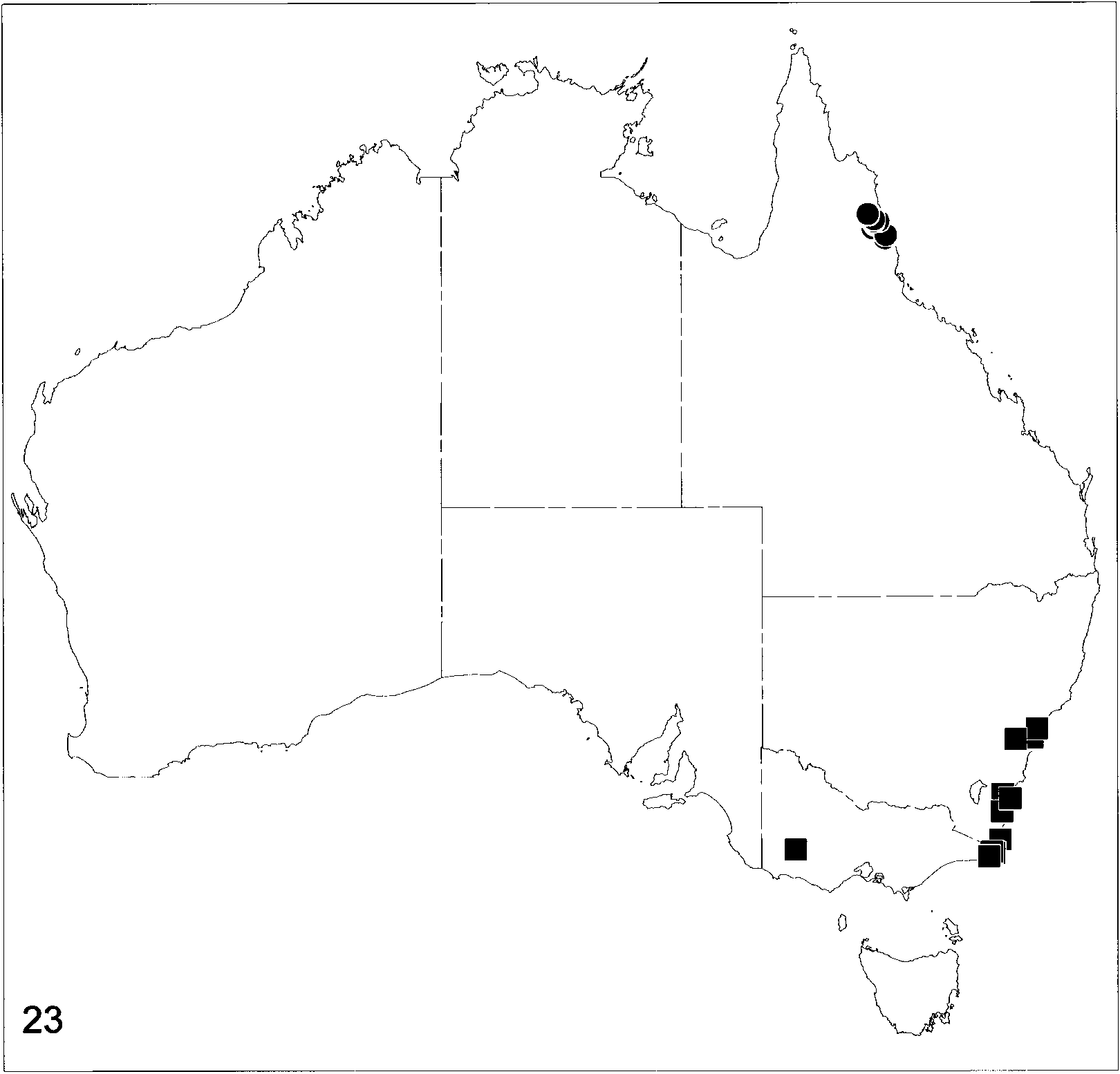
DISTRIBUTION: Known only from northeastern Queensland (map 23).
| QMB |
Queensland Museum, Brisbane |
No known copyright restrictions apply. See Agosti, D., Egloff, W., 2009. Taxonomic information exchange and copyright: the Plazi approach. BMC Research Notes 2009, 2:53 for further explanation.
|
Kingdom |
|
|
Phylum |
|
|
Class |
|
|
Order |
|
|
Family |
|
|
Genus |