
Fluminicola seminalis, (HINDS, 1842)
|
publication ID |
https://doi.org/ 10.1111/j.1096-3642.2007.00243.x |
|
DOI |
https://doi.org/10.5281/zenodo.10544943 |
|
persistent identifier |
https://treatment.plazi.org/id/03BC4773-0B74-F731-43A4-FB4A1B51F8DB |
|
treatment provided by |
Felipe |
|
scientific name |
Fluminicola seminalis |
| status |
|
FLUMINICOLA SEMINALIS ( HINDS, 1842)
Paludina seminalis Hinds, 1842: 83–84 (type locality, Rio Sacramento, California) [see Hershler & Frest (1996) for a detailed synonymy of this species].
Referred material: CALIFORNIA. Lassen County: USNM 1020741 View Materials , Ash Creek on west side of Ash Valley Road (Modoc County 527), Ash Valley (692080 E, 4551080 N, 1536 m), 23 July 2002 TF, EJ. – USNM 1020742 View Materials , Ash Creek north-west of Ash Creek Campground, below (west of) FS22 and a spring, Modoc National Forest (682130 E, 4558830 N, 1462 m), 19 September 2001 TF, EJ. – USNM 1020748 View Materials , Ash Creek on south side of FS39N50 bridge, 1.6 km east of Hunsinger Draw, Modoc National Forest (685560 E, 4555260 N, 1498 m), 20 July 2002 TF, EJ . Shasta County: USNM 883742 View Materials , Big Lake at Rat Farm Public Fishing Access, 0.8 km north of Rat Farm site, Pacific Gas and Electric land (635100 E, 4551300 N, 1008 m), 25 October 1992 TF, EJ. – USNM 1020736 View Materials , ibid., 30 August 2001 TF, EJ. – USNM 1020737 View Materials , Baum Lake (impoundment of Hat Creek) just offshore from a boat ramp, north of parking lot of Baum Lake Public Fishing Access (Pacific Gas and Electric), off Hat Creek Powerhouse Road, north-west of Crystal Lake State Hatchery, north of Cassel (622400 E, 4532260 N, 908 m), 30 August 2001 TF, EJ. – USNM 1020738 View Materials , Fall River at Caltrout Public Fishing Access Area just east of Island Road bridge, south of The Island , north of Glenburn (626700 E, 4549500 N, 1008 m), 30 August 2001 TF, EJ. – USNM 1020739 View Materials , Baum Lake west of a boat ramp, north-west of parking lot of Baum Lake Public Fishing Access (Pacific Gas and Electric), off Hat Creek Powerhouse Road, north-west of Crystal Lake State Hatchery, north of Cassel (622360 E, 4532260 N, 908 m), 30 August 2001 TF, EJ. – USNM 1020743 View Materials , Crystal Springs, Ahjumawi Lava Springs State Park (630328 E, 4552200 N, 1008 m), 26 September 2001 TF, EJ. – USNM 1020744 View Materials , 1020745 View Materials , Big Lake Springs west spring pool, north end of Big Lake , Ahjumawi Lava Springs State Park (633640 E, 4554560 N, 1008 m), 27 September 2001 TF, EJ. – USNM 1020746 View Materials , Pit River on south-east side of CA 299 bridge near (upstream of) confluence of Hat Creek , Pacific Gas and Electric public fishing access (622340 E, 4537400 N, 840 m), 29 September 2001 TF, EJ. – USNM 883739 View Materials , Pit River on south side, c. 0.64 km above footbridge, upstream of Pit 1 Powerhouse (627240 E, 4538620 N, 894 m), 12 September 1993 TF, EJ. – USNM 1020747 View Materials , Spring Creek on south side of Spring Creek Road (624470 E, 4550920 N, 1008 m), 29 September 2001 TF, EJ. – USNM 1020749 View Materials , Lava Creek at boathouse on Hanna Estate (626800 E, 4552380 N, 1008 m), 2 November 2002 TF, EJ. – USNM 1020750 View Materials , spring source and pool of Lava Creek tributary north of boathouse on Hanna Estate (626660 E, 4552570 N, 1008 m), 2 November 2002 TF, EJ. – USNM 883180 View Materials , Lava Creek at and west of Island Road bridge near mouth to Eastman Lake, Lava Creek Ranch, north side of The Island , c. 8.4 km north of Glenburn 102 (626720 E, 4551820 N, 1008 m), 18 August 1991 TF, EJ, JJ. – USNM 1020751 View Materials , spring on west side of Spring Creek, flowing out under east side of road, c. 1.38 km north-west of junction with Spring Creek Road, Spring Creek Ranch (625020 E, 4552070 N, 1009 m), 6 November 2002 TF, EJ. – USNM 1020752 View Materials , Lava Creek source spring pool, Spring Creek Ranch (626050 E, 4553040 N, 1008 m), 6 November 2002 TF, EJ. – USNM 1020804 View Materials , spring on west side of run of Thousand Spring, 0.32 km south-west of source of Thousand Springs, south of Mares Meadow , Thousand Springs Ranch (621560 E, 4552530 N, 1011 m), 1 September 2001 TF, EJ. – USNM 1020805 View Materials , west spring source of Mallard Creek , west of source of Thousand Springs, Thousand Springs Ranch (621120 E, 4552740 N, 1011 m), 1 September 2001 TF, EJ. – USNM 1020806 View Materials , Pit River, 0.81 km south-west of Pit 4 Dam, 0.48 km north-east of Ruling Creek mouth, south-east side of Chalk Mountain off FS50, Shasta National Forest (603010 E, 4537620 N, 721 m), 19 October 1992 TF, EJ. – USNM 1020807 View Materials , below dam diverting Hat Creek into a canal for Hat 1 Powerhouse, north side of Cassel Road bridge, Cassel (622040 E, 4530600 N, 970 m) 24 October 1992 TF, EJ. – USNM 1020808 View Materials , Crystal Lake at south-west end off Hat Creek Powerhouse Road, c. 0.97 km west of Crystal Lake State Fish Hatchery (621140 E, 4532360 N, 911 m), 17 August 1991 TF, EJ, JJ. – USNM 1020809 View Materials , Pit River, c. 0.2 km east of Pit River Fish Hatchery, below Lions Club Picnic area spring channels (east end) (625360 E, 4538080 N, 868 m), 20 October 1994 TF, EJ. – USNM 1020810 View Materials , Ja She Creek on south-east side of bridge of Lava Springs Rim Trail, Ahjumawi Lava Springs State Park (629680 E, 4552170 N, 1008 m), 26 September 2001 TF, EJ. – USNM 883188 View Materials , west side of McCloud River south of the McCloud Bridge (Gilman Road, FS 27), north of the McCloud Bridge Campground, Whiskeytown – Shasta – Trinity National Recreation Area (563620 E, 4532200 N, 317 m), 15 October 1992 TF, EJ. – USNM 1020740 View Materials , Battle Creek on east side of Coleman Fish Hatchery Road, 1.29 km east of Coleman Fish Hatchery , near (upsteam of) former site of pedestrian suspension bridge (573950 E, 4472540 N, 134 m), 28 August 2001 TF, EJ. – USNM 883465 View Materials , Battle Creek near county park off Jellys Ferry Road, c. 0.16 km east of road on north side of creek near Tehama / Shasta County line (569860 E, 4471400 N, 111 m), 13 September 1993 TF, EJ .
Diagnosis: Readily differentiated from other regional pebblesnails by its large size (up to 8.0 mm shell height), very thin shell parietal lip, thick periostracum, very large central cusps of the central and lateral radular teeth, and smooth, rather elongate, penis.
Description: Hershler & Frest (1996) provided a detailed description of this species. A few aspects of this description are emended or expanded below, and some additional details are also provided, based on our study of a larger amount of new material.
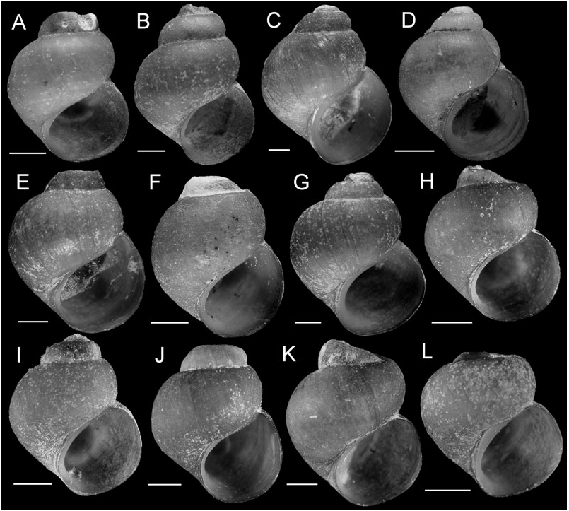
Shell ( Fig. 18 View Figure 18 ) subglobose to ovate-conic. Shell body whorl sometimes having a distinct, subsutural angulation. Outer lip orthocline or weakly prosocline. Shell periostracum thickened. Last 0.5–0.75 whorl of operculum frilled. Cutting edge of central radular tooth near horizontal or slightly convex, lateral cusps two to eight; basal cusps one to three; basal tongue Ushaped, even with lateral margin. Inner marginal teeth having 13–23 cusps. Outer marginal teeth having 18–33 cusps; basal wing rectangular. Osphradium elongate, positioned opposite middle of ctenidium. Bursa copulatrix globose or pyriform (horizontal). Seminal receptacle small. Penis medium or large.
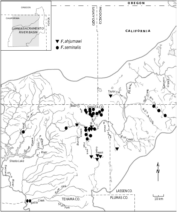
Distribution: The new records provided above extend the distribution of this species within the Pit River basin ( Fig. 17 View Figure 17 ).
Remarks: The populations in lower Ash Valley ( Fig. 17 View Figure 17 ) are distinguished by their small and frequently subglobose-shaped shells ( Fig. 18D View Figure 18 ), but otherwise are identical with this species in all morphological details. Mitochondrial DNA sequences differed among lower Ash Valley populations by 0.2– 0.6% ( COI) and 0% (cytb), and varied among other populations of F. seminalis included in this study by 0–1.4% ( COI) and 0–0.6% (cytb). The mean genetic distances between Ash Valley and other F. seminalis haplotypes were 0.91% ( COI) and 0.18% (cytb).
In all of the phylogenetic analyses, F. seminalis was depicted (often with strong bootstrap support) as sister to F. modoci , with these two species forming clade B. On the basis of sequence divergence, these species differ by 5.0–6.1% ( COI) and 6.4–8.0% (cytb).
| TF |
Department of Mineral Resources |
| EJ |
Ein Yabrud collection catalogue entries at The Hebrew University |
| COI |
University of Coimbra Botany Department |
No known copyright restrictions apply. See Agosti, D., Egloff, W., 2009. Taxonomic information exchange and copyright: the Plazi approach. BMC Research Notes 2009, 2:53 for further explanation.
|
Kingdom |
|
|
Phylum |
|
|
Class |
|
|
Order |
|
|
Family |
|
|
Genus |
Fluminicola seminalis
| Hershler, Robert, Liu, Hsiu-Ping, Frest, Terrence J. & Johannes, Edward J. 2007 |
Paludina seminalis
| Hinds RB 1842: 84 |