
Gonolobus fraternus Schlechtendal (1833: 521)
|
publication ID |
https://doi.org/ 10.11646/phytotaxa.530.2.2 |
|
DOI |
https://doi.org/10.5281/zenodo.5832668 |
|
persistent identifier |
https://treatment.plazi.org/id/03DEFD71-E424-265B-AE9A-A29DFABAF8C5 |
|
treatment provided by |
Plazi |
|
scientific name |
Gonolobus fraternus Schlechtendal (1833: 521) |
| status |
|
Gonolobus fraternus Schlechtendal (1833: 521) View in CoL .
Type:— MEXICO. Veracruz: Hacienda de la Laguna , August 1829, C.J.W. Schiede 162 (Holotype, HAL-98553, photo!; isotypes MO /BC: MO-078171 , photo!, MO /A:2760903, photo!)
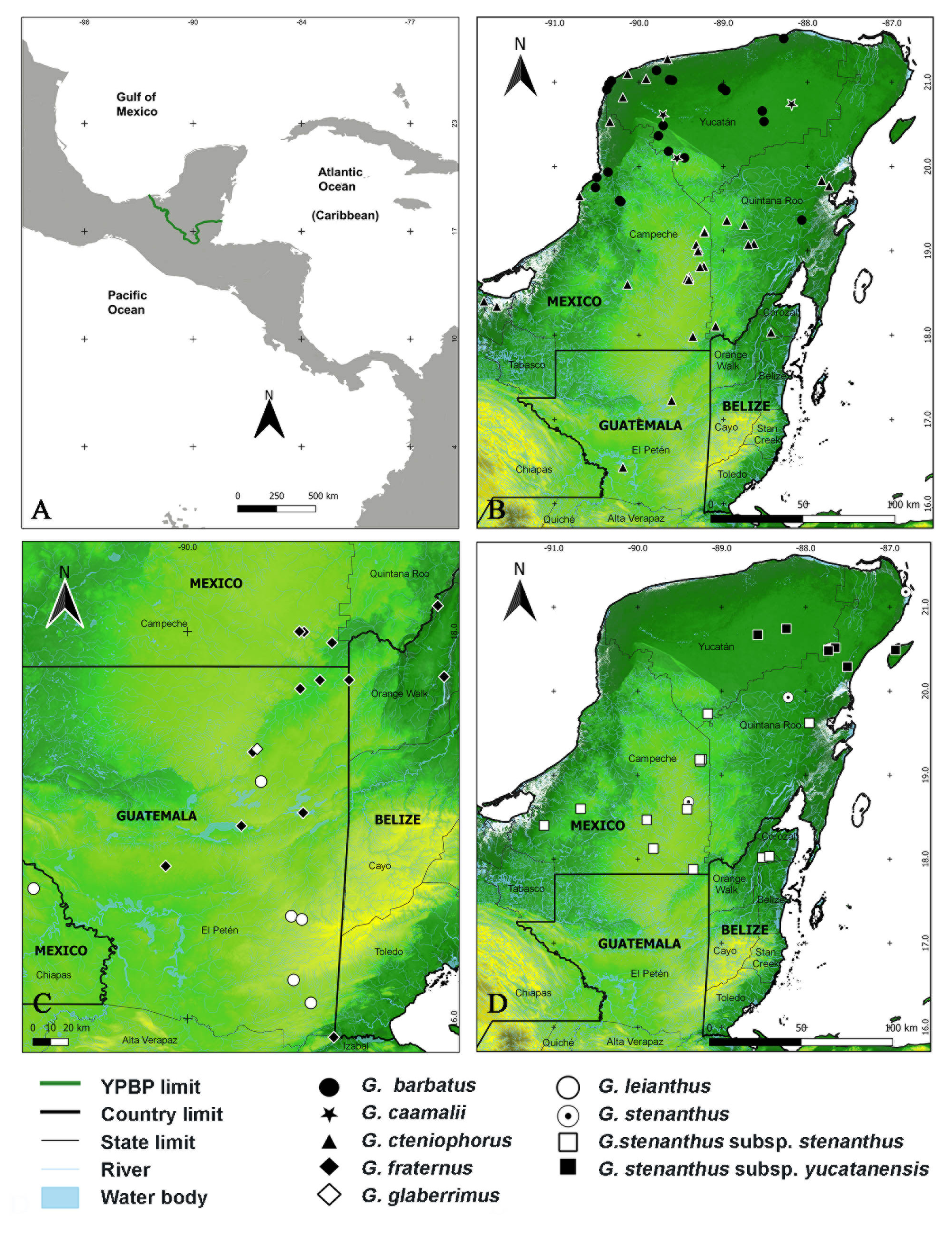
Notes:—This is a species from tropical to premontane humid forests at elevations of 50–1000(–1900) m. It is widespread in Mexico, particularly on the Atlantic slope from Tamaulipas southward to the Guatemalan Petén. It is much more uncommon on the Pacific drainage, with records in coastal Oaxaca, Guerrero, and Michoacán. It is relatively common in the southern, more humid portions of the YPBP, particularly in the Guatemalan Petén and northern Belize.
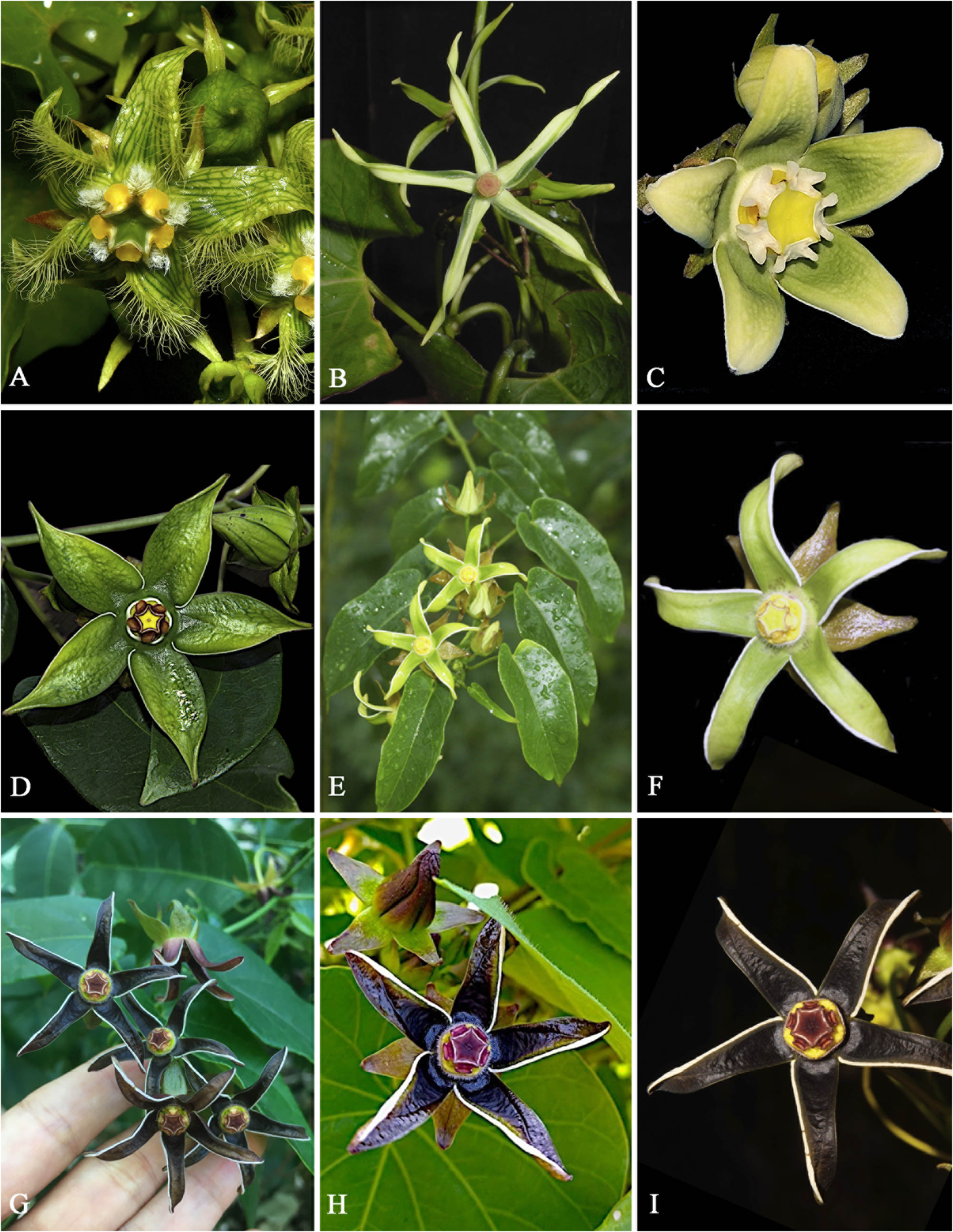
The species is distinctive in its anther appendages, which are distally bilobed (hence the name). They are white and also relatively large as compared with other local Gonolobus . The petals are elliptic, not obviously bent dextrogyrously, rounded to obtuse at apex and the corolla is shortly cup-like at the base ( Figs. 1C View FIGURE 1 , 3C View FIGURE 3 ).
Specimens examined — MEXICO. Campeche: Mun. Calakmul, a 11 km al S de Ley de Fomento Agropecuario, camino a Dos Naciones , 17°59’52” N, 89°23’13” W, 300 m, 21 May 1997, E. Martínez S., D. Álvarez & P. Álvaro M. 27372 ( MEXU) GoogleMaps ; a 7.9 km al NO de El Civalito , 17°56’32” N, 89°14’22” W, 81 m, 18 May 2002, D. Álvarez & J. Calónico S. 1276bis ( MEXU) GoogleMaps ; a 7.3 km al S del poblado Ley de Fomento Agropecuario , 17°59’57” N, 89°24’43” W, 247 m, 12 August 2003, D. Álvarez 6177 ( MEXU) GoogleMaps ; a 10 km al SE de Ley de Fomento Agropecuario, camino a Dos Naciones , 18°N, 89°42’41” W, 205 m, 23 October 1997, E. Martínez S., D. Álvarez, S. Ramírez, E. Lira & E. Madrid 29136 ( MEXU) GoogleMaps . Quintana Roo: Mun. Othón P. Blanco, Civalito , L. Ibarra-González s.n. (unvouchered) GoogleMaps . BELIZE. Orange Walk: 3.3 km S of Program for Belize Camp , 17°45’ N, 89°09’ W, 15 May 1991, R. Arvigo, P. Cocom, R. Cocom, N. Romero, G. Shropshire & J. Woodland 529 ( MO) GoogleMaps ; 0.5 m N of San Antonio village , 18°08’ N, 88°41’ W, 29 June 1974, P.W. Leino 306 ( MO) GoogleMaps ; Indian Church , 17°46’ N, 88°39’ W, 15 May 1977, T. Arnason & J. Lambert 17543 ( MO) GoogleMaps . GUATEMALA. Petén: East of km 179, on Cadenas Road , 15°54’14” N, 89°13’49” W, 14 June 1970, E. Contreras 10065 ( MEXU, MO) GoogleMaps ; [Sitio arqueológico], en el camino que conduce al caserío La Llorona, 2.0– 3.5 km [SO] de la aldea de Uaxactún , 17°22’39” N, 89°39’23” W, 30 May 1973, R. Tun Ortíz 2667 (F) GoogleMaps ; Laguna Yaxja, collection from banks of Laguna Yaxja , 17°03’49” N, 89°23’30” W, 28 June 1970, W.E. Harmon & J.D. Dwyer 2743 ( MO) GoogleMaps ; Parque Nacional Tikal, alrededor del Grupo E, lado N, 17°13’30” N, 89°36’47” W, 28 May 1971, R. Tun Ortíz 1795 (F, MO, NY) GoogleMaps ; Dos Lagunas , El Cedro , km 8, 17°42’16” N, 89°24’25” W, 21 April 1969, E. Contreras 8367 ( DS, MO, NY) GoogleMaps ; Dos Lagunas, Ixcanrio, bordering Ixcanrio River , 17°44’56” N, 89°18’12” W, 24 May 1969, E. Contreras 8636 ( DS, F, MO) GoogleMaps ; Tikal, Tikal National Park , bordering airfield, 17°13’30” N, 89°36’47” W, 5 June 1959, C.L. Lundell 16052 (F, MO, TEX) GoogleMaps ; Cerro Cauhui [Cahui], 16°59’46” N, 89°42’59” W, 20 May 1986, R.L. Walker 1429 ( MO) GoogleMaps ; La Libertad and vicinity, 16°47’17” N, 90°06’53” W, 18 June 1934, M. Aguilar H. 307 ( MO, WIS) GoogleMaps .
| MO |
Missouri Botanical Garden |
| MEXU |
Universidad Nacional Autónoma de México |
| NY |
William and Lynda Steere Herbarium of the New York Botanical Garden |
| DS |
California Academy of Sciences, Dudley Herbarium |
| TEX |
University of Texas at Austin |
| WIS |
University of Wisconsin |
No known copyright restrictions apply. See Agosti, D., Egloff, W., 2009. Taxonomic information exchange and copyright: the Plazi approach. BMC Research Notes 2009, 2:53 for further explanation.
|
Kingdom |
|
|
Phylum |
|
|
Class |
|
|
Order |
|
|
Family |
|
|
Genus |
Gonolobus fraternus Schlechtendal (1833: 521)
| Carnevali, Germán, Romero-González, Gustavo A., Tapia-Muñoz, José Luis, Ramírez-Morillo, Ivón M., Ramírez-Díaz, Claudia J., Cetzal-Ix, William, Stefano, Rodrigo Duno De & Romero-Soler, Katya J. 2022 |
Gonolobus fraternus
| Schlechtendal, D. F. L. 1833: ) |