
Meedo gympie, PLATNICK, 2002
|
publication ID |
https://doi.org/ 10.1206/0003-0090(2002)271<0001:AROTAG>2.0.CO;2 |
|
persistent identifier |
https://treatment.plazi.org/id/03EAE52A-FF83-A67E-8242-24F7D8434B4A |
|
treatment provided by |
Felipe |
|
scientific name |
Meedo gympie |
| status |
sp. nov. |
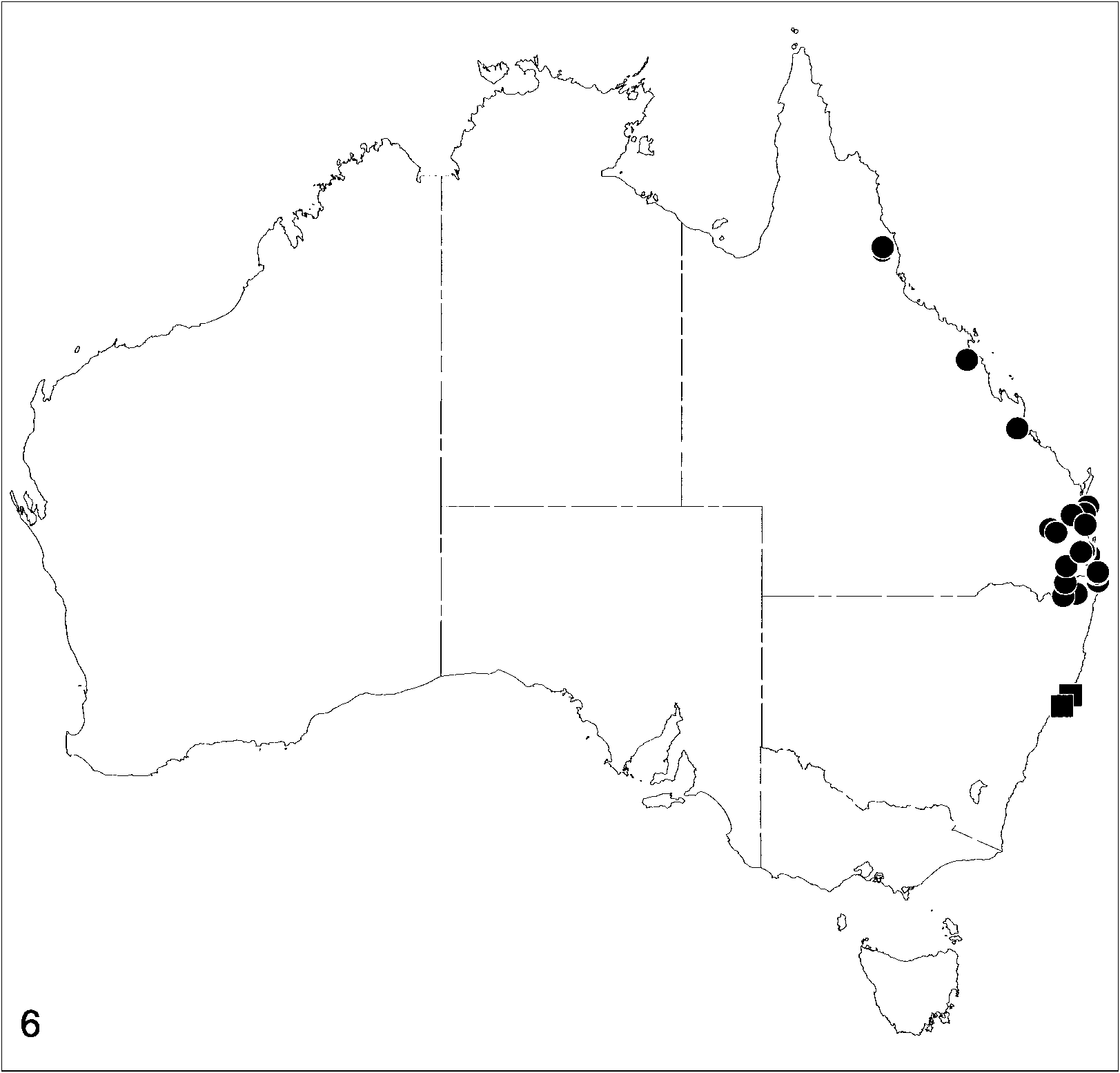
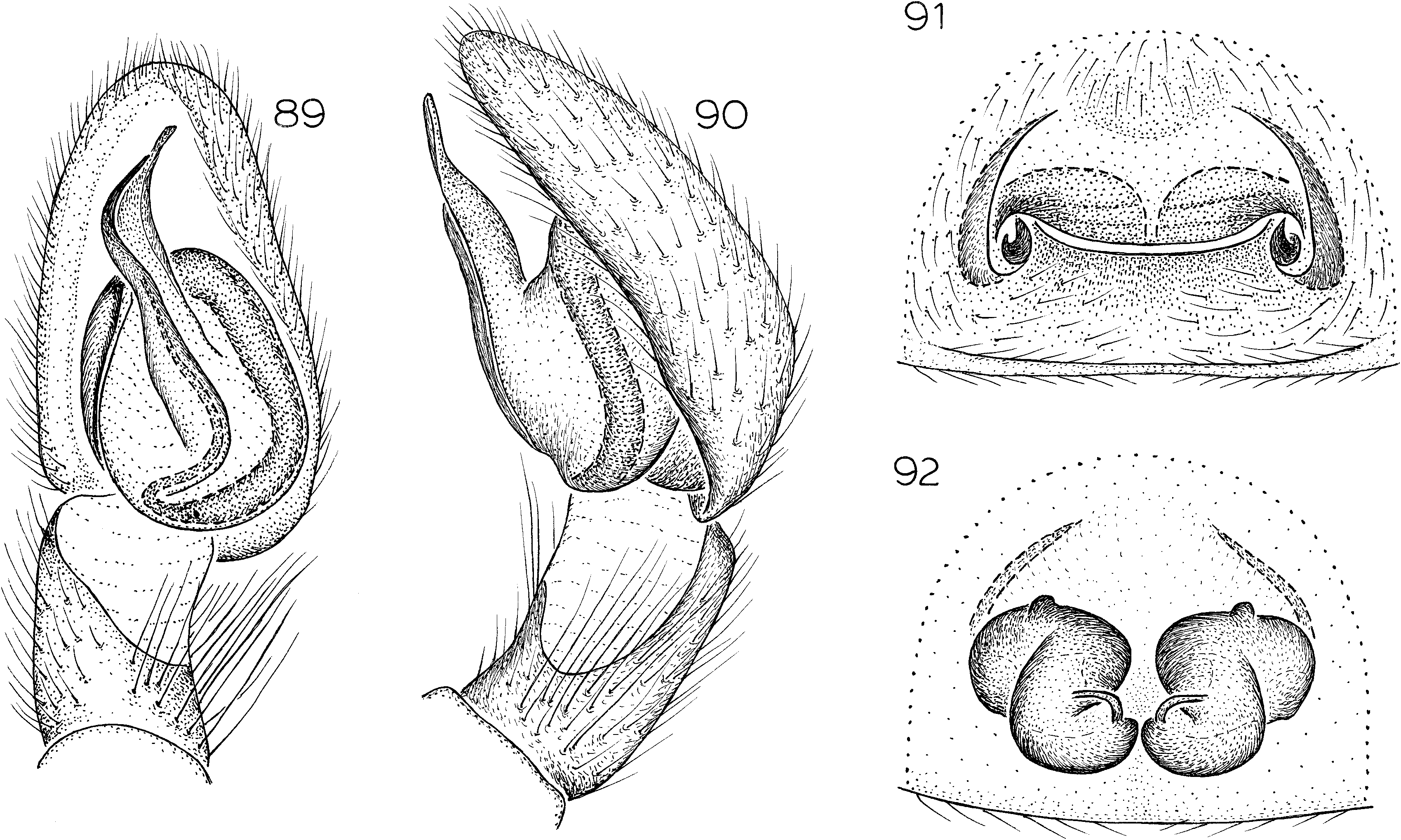
Meedo gympie , new species Figures 89–92 View Figs ; Map 6 View Map 6
NOTE: Scanning electron micrographs of the spinnerets of this species were provided by Platnick (1990, figs. 167–169).
TYPES: Male holotype and female allotype taken in pitfall traps in rainforest at an elevation of 183 m in Marys Creek State Forest, via Gympie , 26 ° 15 ̍ S, 152 ° 35 ̍ E, Queensland (Aug. 11–Nov. 10, 1974; G., S. Monteith), deposited in QMB .
ETYMOLOGY: The specific name is a noun in apposition taken from the type locality.
DIAGNOSIS: This species resembles M. munmorah ; males have a much narrower embolar base (fig. 89), and females have a distinctive epigynum, with a wide, oval atrium (fig. 91) and transversely oriented anterior portions of the spermathecae (fig. 92).
MALE: Total length 5.4. Coloration, mouthparts, and tarsi as in N. munmorah . Retrolateral tibial apophysis absent (fig. 90), unsclerotized portion of tibia occupying more than half of ventral surface; embolar base relatively narrow (fig. 89).
FEMALE: Total length 8.1. Carapace dark brown with black reticulations, abdominal dorsum dark gray, femora, patellae, and tibiae dark brown, metatarsi and tarsi brown. Mouthparts as in N. munmorah . All tarsi entire. Epigynum with wide, oval atrium bearing transverse ridge, broken portions of embolus often protruding from posterolateral corners (fig. 91); spermathecae anteriorly wide, approximate (fig. 92).
OTHER MATERIAL EXAMINED: New South Wales: Cherry Tree State Forest, via Mallanganee , 28 ° 53 ̍ S, 152 ° 45 ̍ E, May 27–Oct. 2, 1978 (G., S. Monteith, QMB), 13 ; Cherry Tree North State Forest , 28 ° 58 ̍ S, 152 ° 15 ̍ E, Dec. 17, 1988, pitfall, dry rainforest, exposed slope. elev. over 300 m (Smith, Hines, Pugh, Webber, AMS KS55284 ), 1♀ ; New Brighton Beach, via Brunswick Heads , 28 ° 29 ̍ S, 153 ° 33 ̍ E, Aug. 3–Nov. 16, 1975, rainforest pitfall, elev. 10 m (G., S. Monteith, QMB), 2♀ ; Rocky Waterholes Road, Beaury State Forest , 28 ° 32 ̍ S, 152 ° 20 ̍ E, Feb. 4–Apr. 9, 1993, pitfall, elev. 705 m (M. Gray, G. Cassis, AMS KS37833 ), 13 ; Stotts Island, 28 ° 14 ̍ S, 153 ° 31 ̍ E, Nov. 19, 1978 (R. Raven, QMB), 1♀. Queensland: Archookoora, via Nanango , 26 ° 43 ̍ S, 151 ° 46 ̍ E, Oct. 26, 1975 – Jan. 25, 1976, rainforest pitfall, elev. 580 m (G., S. Monteith, QMB), 1♀ ; Bellbowrie, Brisbane , 27 ° 33 ̍ S, 152 ° 53 ̍ E, July 1988 (J. Gallon, QMB S28267 View Materials ), 1♀ ; Burleigh Headland, Gold Coast, 28 ° 10 ̍ S, 153 ° 33 ̍ E, May 25–Oct. 13, 1975, rainforest pitfall, elev. 10 m (G., S. Monteith, QMB), 1♀ ; Calamvale, Brisbane , 27 ° 28 ̍ S, 153 ° 03 ̍ E, June 3, 1988 (E. Dahms, QMB S7002 View Materials ), 13 ; Carina Heights, Brisbane , 27 ° 28 ̍ S, 153 ° 01 ̍ E, Feb 1983 (F. Bedford, QMB), 1♀ ; Cooloola , 26 ° 12 ̍ S, 153 ° 03 ̍ E, Oct. 1978, pitfall, high dune (K. Plowman, QMB), 1♀ ; Elginvale , 30 km NE Nanango, 27 ° 58 ̍ S, 152 ° 22 ̍ E, Mar. 26–Oct. 28, 1977, rainforest pitfall, elev. 610 m (G., S. Monteith, QMB), 13 ; Finch Hatton Gorge, Eungella National Park , 21 ° 05 ̍ S, 148 ° 39 ̍ E, July 28–Dec. 3, 1992, pitfall (R. Raven, P., E. Lawless, M. Shaw, QMB S24791 View Materials ), 1♀, Dec. 3, 1992 – Apr. 23, 1993, pitfall (R., J., S. Raven, P., E. Lawless, QMB S24615 View Materials ), 1♀ ; Freshwater Road, Cooloola , 25 ° 58 ̍ S, 153 ° 10 ̍ E, Nov. 10–Dec. 26, 1974, rainforest pitfall, elev. 183 m (G., S. Monteith, QMB), 1♀ ; Gold Creek Reservoir, Brookfield , 27 ° 30 ̍ S, 152 ° 55 ̍ E, Nov. 9, 1975 – Feb. 27, 1976, rainforest pitfall, elev. 110 m (G., S. Monteith, QMB), 1♀, Oct. 1– 15, 1980, pitfall, closed forest (V. Davies, R. Raven, QMB), 1♀ ; Hugh Nelson Range , 17 ° 27 ̍ S, 145 ° 29 ̍ E, Jan. 3–Feb. 4, 1995, pitfall, elev. 1150 m (P. Zborowski, QMB), 1♀ ; Marys Creek State Forest, via Gympie , 26 ° 15 ̍ S, 152 ° 35 ̍ E, Mar. 28–June 16, 1975, rainforest pitfall, elev. 183 m (G., S. Monteith, QMB), 13 ; Mount Coolum , 26 ° 34 ̍ S, 153 ° 05 ̍ E, Jan. 1984, pitfall (B. Jahnke, QMB), 1♀ ; Mount Cotton, Scott’s Dam , 27 ° 36 ̍ S, 153 ° 13 ̍ E, Dec. 12, 1997 – May 7, 1998, rainforest pitfall, elev. 120 m (G. Monteith, QMB S42480 View Materials ), 13 ; Rockhampton, 23 ° 22 ̍ S, 150 ° 32 ̍ E, 1991, pitfall (D. Wallace, R. Raven, QMB S36054 View Materials ), 1♀ ; Wongabel State Forest , 17 ° 20 ̍ S, 145 ° 30 ̍ E, July 23– Nov. 26, 1992, pitfall (R. Raven, P., E. Lawless, M. Shaw, QMB S22620 View Materials ), 1♀ ; 3 km E Yarraman , 26 ° 50 ̍ S, 151 ° 59 ̍ E, Aug. 17–Nov. 10, 1974, rainforest pitfall, elev. 518 m (G., S. Monteith, QMB), 2♀ .
DISTRIBUTION: Northeastern Queensland south to northeastern New South Wales (map 6).
| QMB |
Queensland Museum, Brisbane |
No known copyright restrictions apply. See Agosti, D., Egloff, W., 2009. Taxonomic information exchange and copyright: the Plazi approach. BMC Research Notes 2009, 2:53 for further explanation.
|
Kingdom |
|
|
Phylum |
|
|
Class |
|
|
Order |
|
|
Family |
|
|
Genus |