
Petropedetes newtonii ( Bocage, 1895 ) Photo
|
publication ID |
https://doi.org/ 10.5281/zenodo.11105986 |
|
DOI |
https://doi.org/10.5281/zenodo.11106221 |
|
persistent identifier |
https://treatment.plazi.org/id/03B1733A-FFE0-A143-FFFB-FA25EDB7FDC5 |
|
treatment provided by |
Felipe |
|
scientific name |
Petropedetes newtonii ( Bocage, 1895 ) Photo |
| status |
|
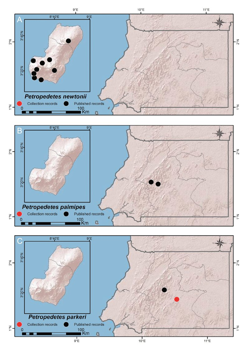
Petropedetes newtonii ( Bocage, 1895) Photo View in CoL figures 19A–B
TYPE LOCALITY.— Restricted by Neotype designation at “Chopepe creek at its confluence with Río Osa (03°14ʹ52.19ʺN, 08°32ʹ23.77ʺE, 27 m a.s.l.), Bioko, Equatorial Guinea ” ( Sánchez-Vialas et al. 2018). Lost holotype from “L’ile de Fernão do Po dans le golfe de Guiné ” ( Bocage, 1895c).
DISTRIBUTION.— This species occurs in both provinces of Bioko (Bioko Norte and Bioko Sur) and in the southern coast of Cameroon (Bakingili and Mt. Etinde region) ( Sánchez-Vialas et al. 2018) ( Map 20A View MAPS ).
COMMENTS.— The taxonomical problems relating to the identity of this taxon were discussed by Sánchez-Vialas et al. (2018).
SPECIMENS EXAMINED.— Twelve specimens. Campamento Smith, Río Tudela, close to Caldera de Luba , Bioko, 07 March 2007 ( MNCN 46703 View Materials ); Campamento UPM-Río Riaco, Caldera de Luba , Bioko, 10 March 2007 ( MNCN 46708 View Materials ) ; Río Riaco, Caldera de Luba , Bioko, 15 March 2007 ( MNCN 46719 View Materials ) ; Chopepe creek on its confluence with Río Osa, Bioko , 3°14ʹ52.19ʺN, 8°32ʹ23.77ʺE, 22 November 2003 ( MNCN 48728 View Materials ) GoogleMaps ; Río Sibitá, Bococo Avendaño, Bioko , 3°26ʹ46.04ʺN, 8°26ʹ52.39ʺE ( MNCN 48729 View Materials ) GoogleMaps ; Afluent of Río Olé, on track to Caldera de Luba , Bioko, 3°18ʹ27.08ʺN 8°28ʹ24.36ʺE, 25 November 2003 ( MNCN 48730 View Materials ) GoogleMaps ; Río Olé, on the way to Caldera de Luba , Bioko, 3°18ʹ27.08ʺN 8°28ʹ24.36ʺE, 25 November 2003 ( MNCN 48955 View Materials ) GoogleMaps ; Chopepe creek on its confluence with Río Osa, Bioko , 3°14ʹ52.19ʺN, 8°32ʹ23.77ʺE, 25 November 2003 ( MNCN 48956 View Materials ) GoogleMaps ; Río Sibitá, Bococo Avendaño, Bioko , 3°26ʹ46.04ʺN, 8°26ʹ52.39ʺE, 03 December 2003 ( MNCN 48957 View Materials ) GoogleMaps ; Chopepe creek on its confluence with Río Osa, Bioko , 3°14ʹ52.19ʺN, 8°32ʹ23.77ʺE, 22 November 2003 ( MNCN 48958–48959 View Materials ) GoogleMaps ; BBPP camp, Caldera de Luba, Bioko , 3°20ʹ47.32ʺN, 8°29ʹ48.44ʺE, 26 November 2003 ( MNCN 48960 View Materials ) GoogleMaps .
| BBPP |
Bacteriology Branch, Plant Pathology and Microbiology Division, Department of Agricultural Science |
No known copyright restrictions apply. See Agosti, D., Egloff, W., 2009. Taxonomic information exchange and copyright: the Plazi approach. BMC Research Notes 2009, 2:53 for further explanation.
|
Kingdom |
|
|
Phylum |
|
|
Class |
|
|
Order |
|
|
Family |
|
|
Genus |