
Camponotus repens Forel, 1897
|
publication ID |
https://doi.org/ 10.11646/zootaxa.4438.1.1 |
|
publication LSID |
lsid:zoobank.org:pub:55BEB1B1-DA14-4CC4-92EB-1EA98AD6277C |
|
DOI |
https://doi.org/10.5281/zenodo.5987984 |
|
persistent identifier |
https://treatment.plazi.org/id/03C287BB-E85B-FFB9-31A6-4C3EFA28F9F2 |
|
treatment provided by |
Plazi |
|
scientific name |
Camponotus repens Forel |
| status |
|
Camponotus repens Forel View in CoL
( Figures 3A View FIGURE 3 , 4A View FIGURE 4 , 32 View FIGURE 32 , 40 View FIGURES 35–42 )
Camponotus repens Forel, 1897: 187 View in CoL . Lectotype minor worker, present designation, Mojanga, West Madagascar [Mahajanga, Ambatoboeny, Madirovalo, -16.523884, 46.516262, 23 m] (Grandidier), AntWeb CASENT0102437 (MHNG) [examined]. Paralectotypes. 3 minor workers of same data as lectotype but with specimen code: CASENT0102434, CASENT0102438 (MHNG), CASENT0101175 (NHMB). [Combination in Camponotus (Mayria) View in CoL : Forel, 1897: 187. Replacement name of Mayria madagascarensis Forel, 1886a: 4 , a junior secondary homonym of Camponotus niveosetosus madagascarensis Forel, 1886a: 4 View in CoL ].
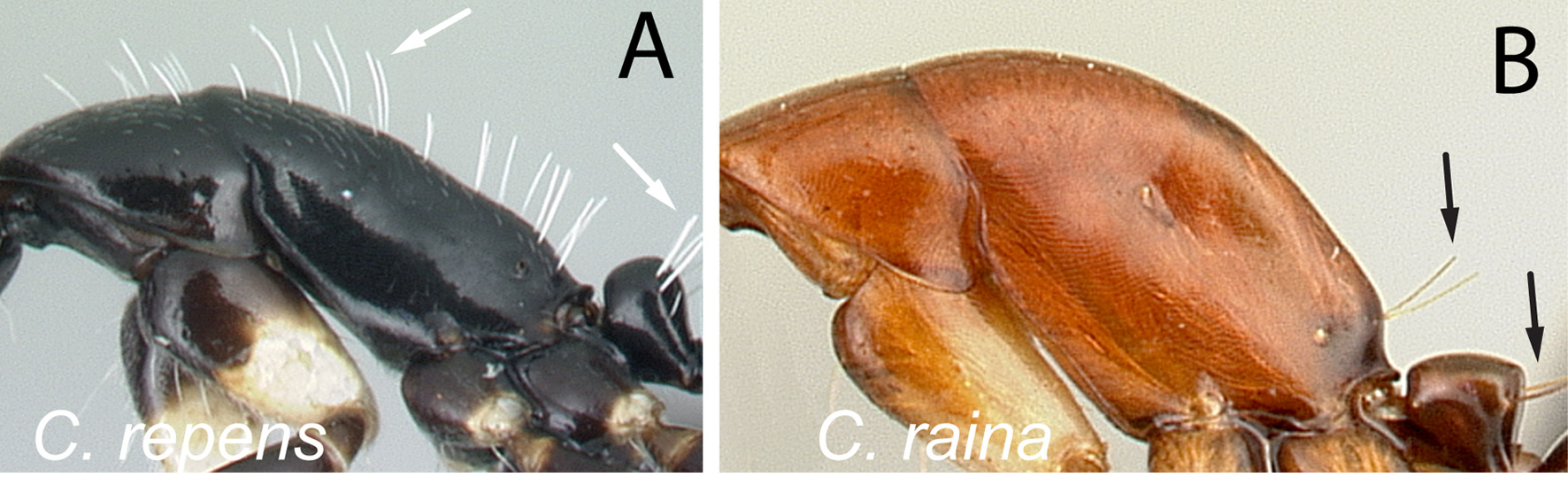
Diagnosis. Median portion of clypeus with longitudinal carina; dorsum of mesosoma covered with numerous slender erect hairs and elongate appressed hairs; in lateral view, petiolar node higher than long; distal portion of procoxa white.
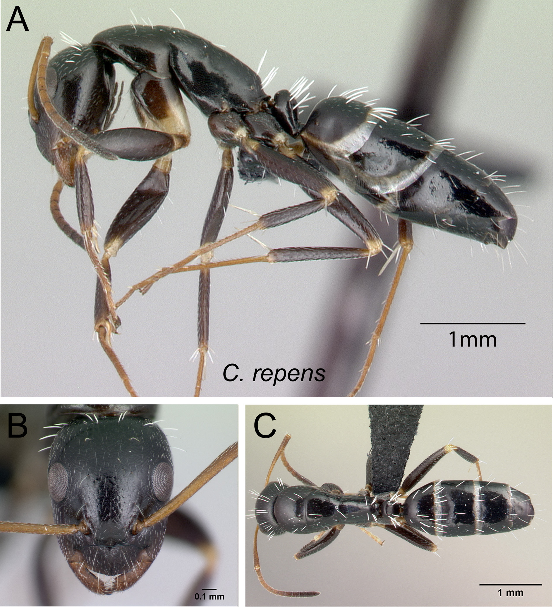
Description. Minor worker. In full-face view, head elongate, oval, with broadly convex posterior margin. Clypeus with truncate anteromedian margin, its junction to lateral margin broadly angulate; clypeal lamella absent. Eyes breaking lateral outlines of head, their posterior margins located well behind the mid-length of the head (PoOc/CL: 0.27±0.01; 0.25–0.29). Mandible triangular, apical margin with six sharp teeth. Antennal scape long, roughly its apical third extending beyond posterior cephalic border. In lateral view, pronotum weakly convex; mesonotum and propodeum more or less straight; propodeal angle roughly rounded; propodeal dorsum roughly one and a half times longer than height of declivity. Petiolar node about as high as long.
Dorsum of body covered with numerous slender, whitish, erect hairs and abundant elongate pubescence. Head, mesosoma, and gaster black; legs generally much lighter in color than body: trochanter, apical portion of coxa and femur whitish-yellow; rest of leg dark brown basally and becoming light brown toward the apex; antennal scape and apical portion of funiculus dark brown and basal portion of funiculus light brown to brown.
Major worker. With characteristics of minor worker except for the following divergent characters: larger head; antennal scape barely surpassing posterior cephalic margin; longitudinal median cariana on posterior half of clypeus; pronotum weakly convex; mesonotum and propodeal dorsum more or less straight and separated by a shallow metanotum; declivity surface rounding to propodeal dorsum.
Discussion. One of the smallest species (CL: 0.8–1.18; PW: 0.54–0.83) in the subgenus Mayria , C. repens can be recognized by its mesosoma dorsum covered with numerous slender erect hairs and elongate appressed hairs, the convex median portion of the clypeus and the white color of the distal portion of the procoxa.
Species delimitation of C. repens on the basis of traditional taxonomic study is congruent with the grouping generated by NC-clustering combined with the PART method. The species was also classified correctly at 100% by the confirmatory LDA.
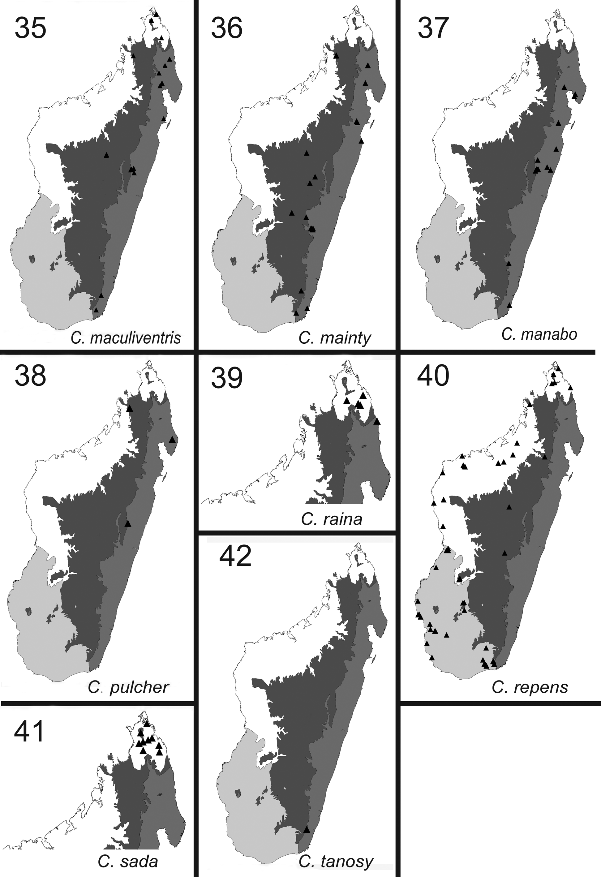
Distribution and biology. Camponotus repens is an endemic, widespread species distributed across the littoral forests and rainforests of the north, the tropical dry forests of the northwest and west, the gallery forests of the central south and southeast, and the spiny forests and thickets in the south of Madagascar. In open habitats like Uapaca woodland, spiny forests and thickets, and a few tropical forests, the nests are found either in the ground or under stones, whereas in most of the dry habitats and the gallery forests the species nests in rotten logs, rot pockets, and rotting tree stumps. Workers have been found foraging in the leaf litter, on the ground and on the lower parts of the vegetation.
Additional material examined. Province Antananarivo: Analamanga Region, District of Ankazobe, Ambohitantely, 46 km NE of Ankazobe, 701 m, -18.198, 47.2815, Forêt sclerophylle, (Rin'ha, Mike) (CASC); Province Antsiranana: Ampasindava, Forêt d'Ambilanivy, 3.9 km 181° S Ambaliha, 600 m, -13.79861, 48.16167, rainforest, (Fisher, Griswold et al.) (CASC); Forêt d'Analabe, 30.0 km 72° ENE Daraina, 30 m, -13.08333, 49.90833, littoral rainforest, (B.L. Fisher et al.) (CASC); Réserve Spéciale de l'Ankarana, 13.6 km 192° SSW Anivorano Nord, 210 m, -12.86361, 49.22583, tropical dry forest, (Fisher, Griswold et al.) (CASC); Réserve Spéciale de l'Ankarana, 22.9 km 224° SW Anivorano Nord, 80 m, -12.90889, 49.10983, tropical dry forest, (Fisher, Griswold et al.) (CASC); Parc National Montagne d'Ambre [1 st campsite ], 960 m, -12.51444, 49.18139, rainforest, (R. Harin'Hala) (CASC); Parc National Montagne d'Ambre [Petit Lac road], 1125 m, -12.52028, 49.17917, rainforest, (R. Harin'Hala) (CASC); Sakalava Beach [vegetated beach dunes], 10 m, -12.26278, 49.3975, across sandy trail in dwarf litoral forest, (R. Harin'Hala) (CASC); Province Fianarantsoa: Amoron'i Mania Region, District of Ambositra, Italaviana Uapaca forest, 135 km SE of Antsirabe, 1359 m, -20.17333, 47.086, Uapaca forest, (Rin'ha, Mike) (CASC); Parc National d'Isalo, Ambovo Springs, 29.3 km 4° N Ranohira, 990 m, -22.29833, 45.35167, Uapaca woodland, (Fisher, Griswold et al.) (CASC); Parc National d'Isalo, Sahanafa River, 29.2 km 351° N Ranohira, 500 m, -22.31333, 45.29167, gallery forest, (Fisher, Griswold et al.) (CASC); stream area, 900 m E of Isalo National Park Interpretive Center, Fianarantsoa Prov., 750 m, -22.62667, 45.35817, open area near stream, (R. Harin'Hala) (CASC); Province Mahajanga: Ampijoroa National Park, 160 km N Maevatanana, Mahajanga Prov., deciduous forest, 43 m, -16.31944, 46.81333, deciduous forest, (Michael Irwin, Rin'ha) (CASC); Boeny Region, District of Soalala, Beaboaly Bamboo forest, 10 km SW of Soalala, 4 km of Baly village, 9 m, - 16.04533, 48.804, bamboo forest, (Mike, Rinha) (CASC); Boeny Region, District of Marovoay, Ampijoroa National Park, 160 km North of Maevatanana on RN 0 4, 42 m, -16.31933, 46.81333, deciduous forest, (Mike, Rinha) (CASC); Boeny Region; District of Soalala, Namoroka 53 km of Soalala, Ambatofolaka dry forest, 3 km N of Vilanandro villlage, 105 m, -16.47333, 45.39133, dense dry forest in the mud, (Mike, Rinha) (CASC); Forêt Ambohimanga, 26.1 km 314° Mampikony, 250 m, -15.96267, 47.43817, tropical dry forest, (B.L. Fisher) (CASC); Forêt de Tsimembo, 8.7 km 336° NNW Soatana, 20 m, -19.02139, 44.44067, tropical dry forest, (Fisher-Griswold Arthropod Team) (CASC); Melaky Region, District of Besalampy, Marofototra palm forest, 17 km W of Besalampy, 10 m, -16.72167, 44.42367, palm trees on sand, (Irwin, Rin'ha) (CASC); Parc National d'Ankarafantsika, Ampijoroa Station Forestière, 40 km 306° NW Andranofasika, 130 m, -16.32083, 46.81067, tropical dry forest, (Fisher, Griswold et al.) (CASC); Parc National de Baie de Baly, 12.4 km 337° NNW Soalala, 10 m, -16.01, 45.265, tropical dry forest, (Fisher, Griswold et al.) (CASC); Parc National de Namoroka, 16.9 km 317° NW Vilanandro, 100 m, -16.40667, 45.31, tropical dry forest, (Fisher, Griswold et al.) (CASC); Parc National de Namoroka, 9.8 km 300° WNW Vilanandro, 140 m, -16.46667, 45.35, tropical dry forest, (Fisher, Griswold et al.) (CASC); Réserve d'Ankoririka, 10.6 km 13° NE de Tsaramandroso, 210 m, -16.26722, 47.04861, tropical dry forest, (Fisher, Griswold et al.) (CASC); Réserve forestière Beanka, 50.2 km E Maintirano, 250 m, -18.02649, 44.05051, tropical dry forest on tsingy, (B.L. Fisher et al.) (CASC); Réserve forestière Beanka, 50.2 km E Maintirano, 153 m, -17.88756, 44.47265, tropical dry forest on tsingy, (B.L. Fisher et al.) (CASC); Réserve forestière Beanka, 50.7 km E Maintirano, 140 m, -17.88021, 44.46877, tropical dry forest on tsingy, (B.L. Fisher et al.) (CASC); Sofia Region, District of Port-Berger, Ambovomamy 20 km N of Port-Berger, 86 m, -15.45117, 47.61333, secondary forest on white sandy area, (Mike, Frank, Rin'ha) (CASC); Station Forestière Ampijoroa, 80 m, -16.31667, 46.81667, tropical dry forest, (P.S. Ward) (PSWC); Province Toliara: 50 km N Morondava, - 20.06667, 44.58333, in primary dry forest, (A. Pauly) (CASC); Anosy Region, District of Amboasary, 58 km SW of Fort Dauphin, 8 km NW of Amboasary, Berenty Special Réserve, 85 m, -25.00667, 46.30333, gallery forest, (Mike, Frank Parker, Rin'ha) (CASC); Anosy Region, District of Amboasary, 58 km SW of Fort Dauphin, 8 km NW of Amboasary, Berenty Special Réserve, 36 m, -25.021, 46.3055, spiny forest, (Mike, Rinha) (CASC); Anosy Region, District of Fort-Dauphin, Andohaela National Park Parcelle II, Tsimela, 42 km W of Fort-Dauphin, 176 m, -24.93683, 46.62667, transition forest, (Michael Irwin, Frank Parker, Rin'ha) (CASC); Anosy Region, Parc National d'Andohahela, Forêt de Manatalinjo, 100 m, -24.82466, 46.60111, spiny forest/thicket, (B.L. Fisher, F.A. Esteves et al.) (CASC); Anosy Region, Parc National d'Andohahela, Forêt de Manatalinjo, 90 m, -24.82505, 46.57811, spiny forest/thicket, (B.L. Fisher, F.A. Esteves et al.) (CASC); Atsimo Andrefana Region, District of Betioky, 30 km E Betioky, Beza Mahafaly Special Reserve (Around Research Station); 165 m, -23.6865, 44.591, dry deciduous gallery forest, (Rin'ha, Mike) (CASC); Fiherenana, 65 m, -23.22252, 43.88088, gallery forest, degraded, (Frontier Project) (CASC); Forêt de Beroboka, 5.9 km 131° SE Ankidranoka, 80 m, -22.23306, 43.36633, tropical dry forest, (Fisher-Griswold Arthropod Team) (CASC); Forêt de Kirindy, 15.5 km 64° ENE Marofandilia, 30 m, -20.06855, 44.659565, tropical dry forest, (B.L. Fisher) (CASC); Forêt de Kirindy, 15.5 km 64° ENE Marofandilia, 100 m, -20.045, 44.66222, tropical dry forest, (Fisher-Griswold Arthropod Team) (CASC); Forêt de Mahavelo, Isantoria River, 110 m, -24.75833, 46.15717, spiny forest/thicket, (Fisher-Griswold Arthropod Team) (CASC); Forêt de Mite, 20.7 km 29° WNW Tongobory, 75 m, -23.52417, 44.12133, gallery forest, (Fisher- Griswold Arthropod Team) (CASC); Forêt de Tsinjoriaky, 6.2 km 84° E Tsifota, 70 m, -22.80222, 43.42067, spiny forest/thicket, (Fisher-Griswold Arthropod Team) (CASC); Forêt Vohidava 88.9 km N Amboasary, 500 m, - 24.24067, 46.28783, spiny forest/dry forest transition, (B.L. Fisher et al.) (CASC); Makay Mts., 570 m, -21.29961, 45.12919, dry forest edge and burned savannah, (B.L. Fisher et al.) (CASC); Makay Mts., 620 m, -21.31664, 45.1296, dry forest on sandy soil, (B.L. Fisher et al.) (CASC); Makay Mts., 525 m, -21.31364, 45.14782, gallery forest on sandy soil, (B.L. Fisher et al.) (CASC); Makay Mts., 500 m, -21.25864, 45.16412, gallery forest with bamboo, (B.L. Fisher et al.) (CASC); Manderano, 70 m, -23.52722, 44.0875, gallery forest, (Frontier Project) (CASC); Manderano, 80 m, -23.52333, 44.09444, spiny thicket, (Frontier Project) (CASC); Menabe Region, District of Morondava,Beroboka village 45 km NE of Morondava, Antsarongaza dry forest 7.5 km E of Beroboka, 50 m, -19.9775, 44.66633, dry forest, (Michael Irwin, Rin'ha) (CASC); Menabe Region, District of Morondava,Beroboka village 45 km NE of Morondava, Antsarongaza gallery forest 7 km E of Beroboka, 45 m, - 19.9775, 44.66533, gallery forest, (Michael Irwin, Rin'ha) (CASC); Parc National d'Andohahela, Forêt d'Ambohibory, 1.7 km 61° ENE Tsimelahy, 36.1 km 308° NW Tolagnaro, 300 m, -24.93, 46.6455, tropical dry forest, (Fisher-Griswold Arthropod Team) (CASC); Parc National d'Andohahela, Forêt de Manatalinjo, 33.6 km 63° ENE Amboasary, 7.6 km 99° E Hazofotsy, 150 m, -24.81694, 46.61, spiny forest/thicket, (Fisher-Griswold Arthropod Team) (CASC); Parc National de Kirindy Mite, 16.3 km 127° SE Belo sur Mer, 80 m, -20.79528, 44.147, tropical dry forest, (Fisher-Griswold Arthropod Team) (CASC); Réserve Berenty, 25 m, -25.01667, 46.3, tropical dry forest, (P.S. Ward) (PSWC); Réserve Privée Berenty, Forêt d'Anjapolo, 21.4 km 325° NW Amboasary, 65 m, -24.92972, 46.20967, spiny forest/thicket, (Fisher-Griswold Arthropod Team) (CASC); Réserve Privée Berenty, Forêt de Bealoka, Mandrare River, 14.6 km 329° NNW Amboasary, 35 m, -24.95694, 46.2715, gallery forest, (Fisher-Griswold Arthropod Team) (CASC); Réserve Privée Berenty, Forêt de Malaza, Mandrare River, 8.6 km 314° NW Amboasary, 40 m, -25.00778, 46.306, gallery forest, (Fisher-Griswold Arthropod Team) (CASC); 3 km E Itampolo, Malaise across path of lower bench of Andrimpano Forest, 45 m, -24.65783, 43.95617, dry forest, (ME Irwin, Rin'ha) (CASC); 5 km N Ampotaka, Malaise on trail in Vitambany gallery forest, 86 m, -24.65033, 43.96317, gallery forest, (ME Irwin, Rin'ha) (CASC); Ambohimahavelona village 33 km NE of Tulear, Andoharano dry forest, 46 m, -23.44083, 43.89967, dry forest, (ME Irwin, Rin'ha) (CASC); Atsimo Andrefana Region, District of Tulear II, Tsifota 20 km N of Manombo, 15 m, -22.818, 43.37267, spiny forest, (ME Irwin, Rin'ha) (CASC); Mikea Forest, deciduous dry forest, Tulear Province, 30 m, -22.90367, 43.4755, deciduous dry forest, (M.E. Irwin, F.D. Parker, R. Harin'Hala) (CASC); Mikea Forest, spiny forest, Tulear Province, 37 m, - 22.91333, 43.48222, spiny forest, (R. Harin'Hala) (CASC); Parcel I, Beza Mahafaly Réserve, near research station, Tulear Province, 165 m, -23.6865, 44.591, dry deciduous forest, (R. Harin'Hala) (CASC); Tsimanampetsotsa National Park, Mitoho Forest, malaise across trail at escarpment base, 120 m, -24.0485, 43.75233, dense dry forest, (ME Irwin, Rin'ha) (CASC); Riv: Menavava Behajomaty, Local: 5 km Mahatsinjo, PLS, (ORSTROM) (CASC).

No known copyright restrictions apply. See Agosti, D., Egloff, W., 2009. Taxonomic information exchange and copyright: the Plazi approach. BMC Research Notes 2009, 2:53 for further explanation.
|
Kingdom |
|
|
Phylum |
|
|
Class |
|
|
Order |
|
|
Family |
|
|
Genus |
Camponotus repens Forel
| Rakotonirina, Jean Claude & Fisher, Brian L. 2018 |
Camponotus repens Forel, 1897 : 187
| Forel, 1897 : 187 |
| Forel, 1897 : 187 |
| Forel, 1886a : 4 |
| Forel, 1886a : 4 |