
Gabbia kessneri, Ponder, 2003
|
publication ID |
https://doi.org/ 10.11646/zootaxa.230.1.1 |
|
publication LSID |
lsid:zoobank.org:pub:AE9A8BE3-1CBD-4958-991A-C6EC1F203AF2 |
|
DOI |
https://doi.org/10.5281/zenodo.5098497 |
|
persistent identifier |
https://treatment.plazi.org/id/0C12051D-2327-FFAA-FECC-FCD3CD85B20D |
|
treatment provided by |
Felipe |
|
scientific name |
Gabbia kessneri |
| status |
sp. nov. |
Gabbia kessneri View in CoL n. sp.
Etymology
Named for Mr Vince Kessner, of Adelaide River, NT, in recognition of his major contributions to this project.
Type material
Heathers Lagoons , west of Adelaide R TS, NT, 12° 54.940'S, 131° 14.200'E, mainly along edges in weed, tree roots and in mud (under water at base of trees), in grass and roots etc., 24 JUN 1996, W.F.Ponder, A.C.Miller, D.L.Beechey & V.Kessner (Holotype, AMS C.417675; paratypes AMS C.322308, 46 wet, 3 dry, 6 on SEM stubs; NTM P21372, 8; QM MO71715, 5) GoogleMaps .
Additional material examined
Melville Island: Melaleuca swamp, Batten Point Rd, 11° 18.000'S, 130° 27.000'E, 24 FEB 1992, Tyler & Davies ( SAM TD 15235 , several) GoogleMaps .
Northern Territory: Mango Farm, Daly R , 13° 30.000'S, 130° 24.000'E, MAY 1997, H. Ronay ( AMS C.324329, 5); SE of Howard Springs GoogleMaps , 12° 28.000'S, 131° 3.000'E, marshy area near creek, 30 MAY 1976, W.Ponder, J.Burch & D. Feughelman ( AMS C.307880, 2; AMS C.307896, 20+); Manton R, just below Manton Dam GoogleMaps , 12° 55.000'S, 131° 4.000'E, 19 MAY 1976, J. Burch, W. Ponder & D. Feughelman ( AMS C.203386, 3); stream crossing Stuart Hwy, N of Manton R, 60 km S of Darwin GoogleMaps , 12° 38.000'S, 131° 4.000'E, on dead fronds, in cloudy, flowing creek, 29 MAY 1976, J. Burch, W. Ponder & D. Feughelman ( AMS C.401251, 2); GoogleMaps Heathers Lagoons, 4.1 km NW of Marrakai Crossing, W of Adelaide R TS, 12° 54.670'S, 131° 13.870'E, 17 SEP 1995, V. Kessner ( VKC 24296, 1 ) GoogleMaps , same locality, 3.9 km NW of Marrakai Crossing GoogleMaps , 12° 54.770'S, 131° 13.920'E, 17 SEP 1995, V. Kessner ( VKC 24294, 15 ; AMS C.318638, 5), 3.5 km NW of Marrakai Crossing GoogleMaps , 12° 55.000'S, 131° 14.250'E, 17 SEP 1995, V. Kessner ( VKC 24295, 1 ) GoogleMaps ; billabong E of Adelaide R, at Marrakai Crossing , 12° 55.510'S, 131° 15.930'E, V. Kessner ( AMS C.307278, 1); small billabong E of Marrakai Crossing, Adelaide R GoogleMaps , 12° 55.570'S, 131° 15.920'E, 12 AUG 1995, V. Kessner ( VKC 24297, 1 ; AMS C.318581, 1); Fogg Dam, SE of Darwin GoogleMaps , 12° 33.950'S, 131° 18.000'E, 02 MAY 1981, V. Kessner ( VKC 7715 , 20 +; AMS C.318568, 6), same locality, on plants and mud in shallow water, 14 JUN 1984, V. Kessner ( AMS C.307275, 4), in shallow water in dam and surrounding swamps, 02 MAY 1981, V. Kessner ( AMS C.307894, 20+), in shallow water, swampy area, on mud and vegetation, 02 MAY 1981, V. Kessner ( QM MO11497 , 9 ) GoogleMaps , 6 JUN 1976, A. Dartnall & B.J. Smith ( MV F 78757 View Materials , 5 ) , on vegetation, in dam and surrounding swamps, 2 MAY 1981, V. Kessner ( MV F 54830 View Materials , 19 ) ; Middle Point jungle, near Fogg Dam, SE of Darwin , 12° 33.330'S, 131° 18.670'E, 24 DEC 1981, V. Kessner ( VKC 7716 , 5 ;AMS C.318588, 2); 15 km off Stuart Hwy, on Beatrice Hill Rd, swamps on black soil plain GoogleMaps , 12° 39.000'S, 131° 19.000'E, muddy water with lilies, 12 JUN 1976, J.Burch, W.Ponder & D. Feughelman ( AMS C.401252, 1; AMS C.307900, 1); Harrison Dam GoogleMaps , 12° 35.220'S, 131° 20.490'E, dense reeds along edge of dam, 24 JUN 1996, W.F.Ponder, A.C.Miller, D.L.Beechey & V. Kessner ( AMS C.318745, 5); canal from Harrison Dam GoogleMaps , 12° 33.270'S, 131° 21.200'E, among dense reeds in water, 24 JUN 1996, W.F. Ponder, A.C. Miller, D.L.Beechey & V. Kessner ( AMS C.318695, 20+), GoogleMaps same locality, 12 MAY 1996, V. Kessner ( AMS C.351073, 13); 4.2 km W of Mt Ringwood Stn HS, E of Howley Ck , 13° 7.820'S, 131° 20.000'E, 10 AUG 1996, V. Kessner ( VKC 24033, 3 ; AMS C.318630; 1, VKC 24034, 3; AMS C.318602, 1); 1.2 km N of Alligator Hole, E of Howley Ck, 5.2 km SW of Mt Ringwood Stn HS GoogleMaps , 13° 8.950'S, 131° 19.720'E, 10 AUG 1996, V. Kessner ( VKC 24032, 8 ; AMS C.318578, 1); near Mt Keppler Stn HS, E of Margaret R GoogleMaps , 13° 1.500'S, 131° 22.750'E, 13.5 km NE, 26 JUL 1996, V. Kessner ( VKC 24030, 5 ; AMS C.318611, 1), same locality, 10.8 km NE GoogleMaps , 13° 2.250'S, 131° 21.250'E, 26 JUL 1996, V. Kessner ( VKC 24031, 14 ; AMS C.318590, 2), 10.2 km NE GoogleMaps , 13° 2.330'S, 131° 21.070'E, 26 JUL 1996, V. Kessner ( VKC 24029, 14 , AMS C.318563, 2), 10.8 km NE GoogleMaps , 13° 20.250'S, 131° 21.250'E, small billabong, mud, weeds, 15 APR 1997, V.Kessner ( AMS C.203385, 20+); Buba Billabong GoogleMaps , 12° 51.183'S, 132° 44.866'E, 30 MAY 1996 ( AMS C.203651, 5; AMS C.203654, 6), same locality, 25 MAY 1995 ( AMS C.203653, 5); Georgetown Billabong , 4 km SE Jabiru Mining Camp GoogleMaps , 12° 40.000'S, 132° 52.000'E, necton sample, 19 DEC 1974, R. Pengelly ( MV F 4839 , 10 ) GoogleMaps ; swamp on Wulunurrayi Ck , just off rd, 15° 18.350'S, 135° 20.200'E, on weed, 21 MAY 1997, W.F.Ponder, V. Kessner & D.L.Beechey ( AMS C.326791, 20+) GoogleMaps .
Description
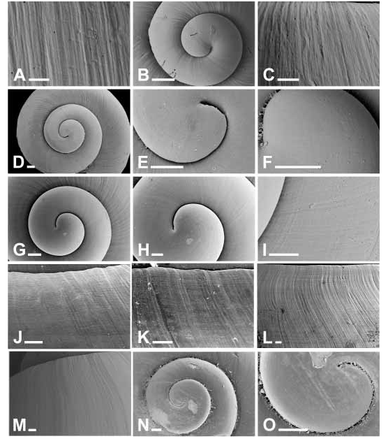
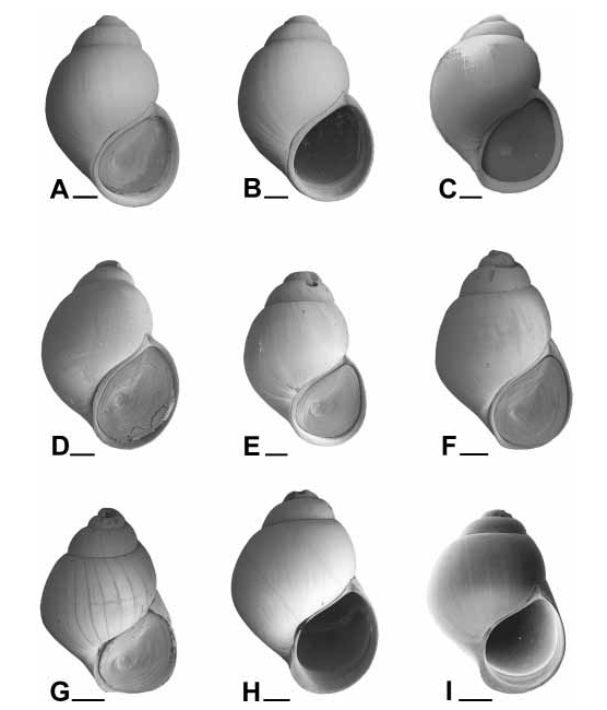
Shell ( Fig. 14K,M View FIGURE 14 , 25 View FIGURE 25 AE) large (up to 11 mm in length), ovate, with up to 4.7 lightly convex whorls. Protoconch not examined (eroded in available material). Teleoconch sculptured with fine collabral growth lines and a few fine spiral grooves, especially on upper part of whorls; base evenly convex; umbilicus closed. Aperture broadly ovate, evenly rounded to very slightly subangled anteriorly; peristome thin; outer lip prosocline, very narrowly reflected in mature specimens. Colour: greenishyellow to olivebrown, rarely with collaboral thin brown lines; peristome often dark brown to almost black; shell opaque to semitranslucent; periostracum thin and smooth, often conspicuous. Varices rarely present, if present, usually only one on last half of last whorl, dark brown, slightly raised.
Dimensions. See Table 20 for dimensions of holotype and figured paratypes and Appendix, Table 29 View TABLE 29 , for summary shell dimensions and whorl counts.
Operculum ( Fig. 27A,B View FIGURE 27 ) typical of genus. Ovate, white (sometimes stained brown), near flat to slightly concave, concentric growth lines distinct but not forming heavy ridges; inner surface with muscle scar occupying most of surface, sculptured with weak pustules and, sometimes, wrinkles.
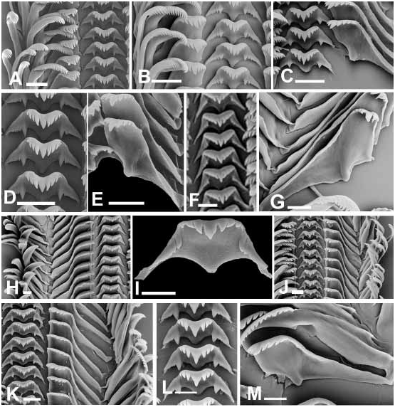
Radula (Appendix Table 30 View TABLE 30 ; Fig. 28 View FIGURE 28 FI) typical of genus. Central teeth with 36 cusps on either side of median cusp which is up to nearly twice as long as adjacent cusps and its base up to nearly twice as wide; median cusp proximally parallelsided to tapering, distally papillalike to rapidly tapering and pointed. Face of central tooth with 14 pairs of cusps that extend just inside lateral margin forming weakly denticulate to simple ridge, inner pair larger than others (if others present), small (about quarter of total height of tooth), other cusps small or, usually, subobsolete to obsolete; lateral margins straight, at about 5070º; basal tongue prominent, narrow, with rounded end. Lateral teeth with cusp formula 23 + 1 + 35; with cutting edge about 0.300.48 length of lateral part of tooth; median cusp longer than adjacent cusps, broad and blunt; upper edge of lateral part of tooth at about 5070 º to cutting edge, lateral edge slightly to moderately concave. Inner marginal teeth with 1220 cusps, outer marginals with 618 cusps.
Headfoot unpigmented to pale to dark grey, tentacles paler than rest of head to unpigmented. Mantle roof mostly grey to black with white spots, grey to black on right; visceral coil unpigmented.
Anatomy. Gill ( Fig. 6H View FIGURE 6 ) with apices at or very near right edge along entire gill to about fifth gill width or, in some, at about fifth to quarter gill width from right in posterior third; 7398 filaments (n=3). Osphradium opposite middle of gill to opposite anterior half. Penis with accessory lobe subequal to shorter than penial lobe, distal end of accessory lobe simple; accessory gland medium length. Pallial oviduct ( Fig. 8C View FIGURE 8 ) similar to G. vertiginosa but with narrower capsule gland; bursa copulatrix extending to end of capsule gland (AMS C.351073, AMS C.203385; AMS C.322308).
Distribution ( Fig. 29 View FIGURE 29 ) and habitat. Western side of Arnhem Land, Northern Territory in billabongs and other large semipermanent water bodies. Lives mainly on submerged macrophytes. One lot from Melville Island is only tentatively attributed to this taxon.
Remarks
Differs from all other Australian species, other than G. beecheyi n.sp. described below, in its large, greenish, smooth, shining, ovate shell with convex spire outlines that resembles the type species of Bithynia s.s. This species, and the next, are, however, included in Gabbia because the configuration of the female reproductive system is similar to that of the other species included in that group. Gabbia kessneri differs from G. beecheyi in usually being slightly larger and in having the aperture more rounded anteriorly. See remarks under G. beecheyi for more detailed comparisons.
A single lot from Melville Island consisting entirely of submature individuals cannot be determined with any confidence. It has some shell features that are similar to G. beecheyi n.sp. but is geographically closely associated with G. kessneri to which it is tentatively referred.


| R |
Departamento de Geologia, Universidad de Chile |
| SAM |
South African Museum |
| QM |
Queensland Museum |
| MV |
University of Montana Museum |
No known copyright restrictions apply. See Agosti, D., Egloff, W., 2009. Taxonomic information exchange and copyright: the Plazi approach. BMC Research Notes 2009, 2:53 for further explanation.
|
Kingdom |
|
|
Phylum |
|
|
Class |
|
|
Order |
|
|
Family |
|
|
Genus |