
Solanum phaseoloides, Pol.,
|
publication ID |
https://doi.org/ 10.1600/036364411X605074 |
|
DOI |
https://doi.org/10.5281/zenodo.6329707 |
|
persistent identifier |
https://treatment.plazi.org/id/03BC87C5-FFF0-8221-FF5D-F90D5F8697DE |
|
treatment provided by |
Tatiana |
|
scientific name |
Solanum phaseoloides |
| status |
|
9. SOLANUM PHASEOLOIDES Pol., View in CoL
Linnaea 41: 585. 1877.
— TYPE: COSTA RICA. Alajuela: Desengaño , Jun 1875 (fl), H. Polakowsky 147 (lectotype, here designated: BM–BM000579755 !; isolectotype: B [destroyed]).
Solanum olivaeforme Donn.Sm., Bot.Gaz.(Crawfordsville) 14:28. 1889.
—TYPE: GUATEMALA. Alta Verapáz: Pansamalá , 3,800 ft, May 1887 (fl), H. von Tuerckheim 1226 (lectotype, here designated: US–US00027712 !; isolectotypes: GH–GH00077524!, K–K000449425!, NY–NY00169750!).
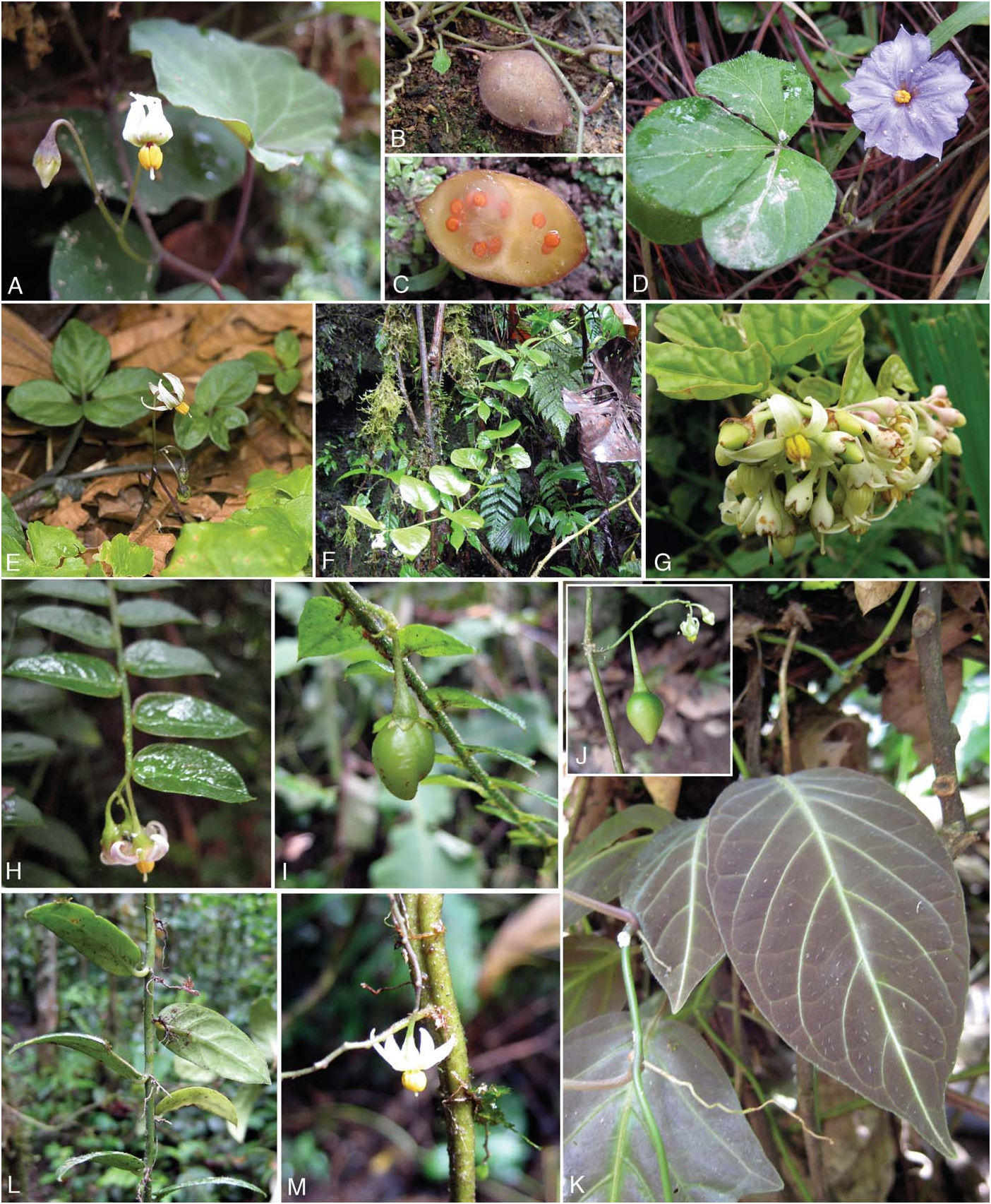
Herbaceous vine, terrestrial. Stems slender, glabrous or rarely pubescent with slender trichomes 0.8–1.5 m long. Sympodial units plurifoliate. Leaves 3-pinnate, the blades 1.5–7.5 × 1–7 cm, about as long as wide, membranous to chartaceous, glabrous adaxially or with widely scattered to dense, wide-diameter trichomes, 0.3–1.2 × 0.1–0.2 mm on the leaf blade, with trichomes like those of the stem more abundant along veins, glabrous abaxially, the margins entire to undulate, minutely revolute on some leaves, the rachis glabrous; lateral leaflets 0.5–5 × 1–5.5 cm, elliptical to rounded, the base oblique, cuneate to cordate on the proximal side, the apex obtuse to acuminate, the petiolules 0.5–3 mm, glabrous; apical leaflet 0.8–4 × 1–6 cm, broadly elliptical to rhomboid, the base cuneate, the apex obtuse to acute, apiculate, the petiolule 1–5 mm, glabrous; petioles 1.5–13 cm, sparsely sand-punctate, glabrous or rarely pubescent. Internodes 3–12 cm. Inflorescences 3–12 cmlong, unbranched, extra-axillary, with (2–)3(–7) flowers, the axes glabrous; peduncle 1.5–5 cm, slender; rachis 1–6.5 cm; pedicels 10–25 mm in flower and fruit, slender, glabrous, spaced 4–8 mm apart. Calyx 1.5–2 mm long, the tube 1–1.5 mm long, the lobes 0.5–1 × ca. 1.5 mm, deltoid to truncate, acute to acuminate at tips, glabrous; fruiting calyx slightly accrescent, the lobes 1–1.2 × 1.5–2 mm, truncate-acuminate. Corolla 1–1.5 cmindiameter, ca. 5 mm long, stellate, white, the tube 1–3 mm, the lobes 6–7 × 1.2–3 mm, lanceolate, acute at the tips, glabrous adaxially and abaxially, the margins ciliate. Stamens with filaments 1–1.5 mm, glabrous; anthers 2–2.5 × ca. 1 mm. Ovary glabrous; style 4–5 × ca. 0.2 mm, cylindrical, glabrous; stigma capitate. Fruits 2–4 × 1–2.5 cm, ovoidrhomboid, flattened, pointed at apex, greenish to yellowish, often mottled, glabrous. Seeds ca. 2 × 1.5 mm in diameter, lenticular, light brown, the surface smooth. Figure 1E View FIG .
Habitat and Distribution— Solanum phaseoloides occurs in the understory of wet forests and in clearings from southern Mexico (Chiapas), Guatemala, Belize, Honduras, Costa Rica, to Panama. It is usually terrestrial, but occasionally grows on fallen logs or as an epiphyte; 500–2,900 m in elevation. Asingle collection is known from Peru ( Fig. 9 View FIG ).
Phenology— Flowering and fruiting occur throughout the year.
Etymology— The name, phaseoloides , refers to the similar leaves and viny habit of the genus Phaseolus L. ( Fabaceae ).
Notes— Solanum phaseoloides is a ground-trailing species characterized by 3-foliate leaves and stellate flowers. It is most similar to S. pentaphyllum from which it differs by its 3-foliate vs. 5-foliate leaves. It also resembles S. trifolium , but can be differentiated by its white, stellate flowers and pointed leaf apices vs. blue-violet, rotate flowers and rounded leaf apices. Vegetative parts of most collections are glabrous; however, plants with pubescent stems and petioles appear to be localized in the Cordillera de Talamanca in Costa Rica at 1,700 – 3,200 m. Asingle collection of S. phaseoloides is known from north-central Peru. The leaves of this collection are somewhat fleshier than typical plants from Central America, but it corresponds to them in other characters. If this specimen truly represents a population of S. phaseoloides , then it is a remarkable disjunction from the species’ native range in Central America. Alternatively, it is possible that this collection represents an additional species of sect. Herpystichum ; however, we must reserve judgment until additional collections are available. We have been unable to successfully obtain a DNA sequence from this Peruvian collection. Finally, we have not seen collections of S. phaseoloides from Nicaragua; however, its presence there is expected based on the overall distribution of this species.
The location Polakowsky’s holotype is not explicitly stated in the protologue; the existence of a specimen at Bis implied, but it has almost certainly been destroyed and no photos of the specimen are known to exist. A duplicate of this collection exists at BM and this specimen (BM000579755) has been chosen as the lectotype.
Donnell Smith did not designate a single sheet of Tuerckheim 1226 as the holotype of S. olivaeforme in his 1889 protologue. The specimen from US ( US 00027712) is here chosen as the lectotype. Donnell Smith’s herbarium is now held at US and this specimen has the original label written in Donnell Smith’s hand.
Representative Specimens Examined— MEXICO. Chiapas: Finca Irelanda, Jun 1914 (fl), C. A. Purpus 7310 (BM, F, GH, NY, UC); Finca Mexiquito, Jun 1913 (fl), C. A. Purpus 7460 ( UC).
GUATEMALA. Alta Verapaz:Barrancade Rubelcruz, 15°29’N 90°08’W, 2,500 ft, Apr 1889 (fr), J. Donnell Smith 1785 (G, GH, M, US); Vicinityof Laguna Sapalá (Chajvuvuch), 280 m, 11 Mar 1942 (fl), J. A. Steyermark 44895 (F, UC). Izabal: Montañas del Mico, 7–8 km Wof Santo Tomás de Castilla on road to microwave tower, 15°40’N 88°40’W, 600–650 m, 19 Aug 1988 (fl, fr), W. D. Stevens et al. 25577 ( NY). Peten: La Cumbre, Pusila road, in high forest, 17 Aug 1976 (fl), C. L. Lundell & E. Contreras 20189 (F, LL). Quetzaltenango: Finca Pirineos, lower south-facing slopes of Volcán Santa María, between Santa María de Jesús and Calahuaché, 1,300 –1,500 m, 31 Dec 1939 (infl), J. A. Steyermark 33254 (F). Retalhuleu: Barrancade Salamá, 1,700 ft, Apr 1892 (fl, fr), J. Donnell Smith 2673 (F, GH, K, M, MO, NY, US, WU); Near Chivolandia (Dept. Quezaltenango), along road to San Felipe, 650 m, 15 Feb 1941 (infl), P. C. Standley 87182 (F). San Marcos: Finca El Porvenir, along Río Chopal, south-facing slopes of Volcán Tajumulco, 1,300 –1,500 m, 11 Mar 1940 (fl), J. A. Steyermark 37528 (F). Suchitepéquez: Southern lower slopes of Volcán Zunil, vicinity of Finca Las Nubes, along Quebrada Chita, Eof Pueblo Nuevo, 500–800 m, 2 Feb 1940 (fl), J. A. Steyermark 35395 (F).
BELIZE. Esperanza Rd, 2600 ft, 2 Jul 1934 (fl), W. A. Schipp 727 (F). Cayo: Chiquibul, Ceibo Grande to Main Divide track, 16°31′49″N 89°05′06″W, 500 m, 26 Aug 1998 (fl), A. K. Monro & S. Cafferty 2689 (BM, MO). Toledo:in high ridge, on hill slope, Edwards road beyond Columbia, 16°14’N 88°14’W, 18 Feb 1948 (fl), P. H. Gentle 6417 ( LL).
HONDURAS. La Muralla visitors center and environs, 8 km NNW of La Union, 15°05’N 86°44’W, 1,415 –1,580 m, 4 Jun 1992 (fl), W. G. D’Arcy 18123 (MO, NY). Yoro: Ca. 16 km from Yarucha on Quebrada de Oro to Cerro Bufalo, 900–950 m, 16 Aug 1982 (fl, fr), W. C. Holmes 4407 ( NY).
COSTA RICA. Rampante - Forets de la Palma, Sep 1898, A. Tonduz 12611 ( US). Alajuela: Primary forest on ridge top between Río Gorrión and Río Toro, 10°12’N 84°19’W, 1,700 m, 7 Oct 1972 (fl), R. Lent 2998 (F). Cartago: Paraíso, P. N. Tapantí-Macizo de La Muerte, Cuenca del Reventazón, 9°45′20”N 83°47′00″W, 1,250 m, 15 Mar 2000 (fl, fr), L. Acosta & V. Ramirez 646 ( NY); El Muñeco, Sof Cartago and Navarro Valley, near boundary of San Joséand Cartago provinces, 4,500 ft, 19 Jun 1928 (fr), H.E. Stork 2659 (F, UC). Heredia: Braulio Carrillo Park, 1,700 –2,000 m, Mar 1983 (st), L. D. Gómez 20200 (MO, NY); Vara Blanca de Sarapiquí, North slope of Central Cordillera, 1,500 –1,750 m, Jul 1937 (fl, fr), A. F. Skutch 3177 (K, MO, NY, US). Puntarenas: Ca. 2 km SE of Monteverde, 10°18’N 84°48’W, 1,500 –1,550 m, 18 Mar 1973 (fl, fr), J.L. Gentry & W. C.Burger 2696 (AAU, F, MO); Cantón de Osa, Fila Costeña, Fila Cruces, cabeceras del Río Piedras Blancas, Cerro Anguciana, faldas al Oeste, 8°48′56″N 83°10′37″W, 1,400 – 1,600 m, 10 Dec 1993, B. Hammel 19293 ( MO); Fila las Cruces near San Vito de Java, 1,400 m, 22 Aug 1974 (fl, fr), P. J. Maas & B. McAlpin 1400 (F, GH, U). San José: Cordillera Talamanca, mountain of Cerro de la Muerte, Panamerican highway between San Isidro El General and Division, 1,900 m, 4 Mar 1966 (fl), A. Molina Rositto et al. 18354 (BM, F, GH, NY); San José, slopes of Cordillera de Talamanca Nof San Isidro El General, 1,750 –2,000 m, 5 Feb 1963 (fl), L. O. Williams et al. 24342 (F, G, GH, NY).
PANAMA. Chiriqui: Vicinity of Fortuna Dam, Sof lake on Eside of river valley across river, 1,400 m, 7 Feb 1987 (fl, fr), L. Bohs & G. McPherson 2311 ( GH); 3.5 mi NE of Boquete, end of road along Río Palo Alto, 17 Nov 1978 (fr), B. Hammel 5679 ( MO); Vicinityof Fortuna Dam, 8°45′04″N 82°15′04″W, 1,300 –1,400 m, 7 Feb 1987 (fr), G. McPherson 10387 ( MO). Veraguas: 5 mi Wof Santa Fe on road past Escuela Agrícola Alto Piedra on Pacific side of divide, 800–1,200 m, 18 Mar 1973 (fl), R. L. Liesner 948 (C, F, L, LL, NY).
PERU. San Martín: Cataratas de Ahuashiyacu, km 15 Tarapoto- Yurimaguas Road, 6°29’S 76°21’W, 700 m, 10 Jun 1986 (fl), S. Knapp & P. Alcorn 7791 ( MO).

| UC |
Upjohn Culture Collection |
| Wof |
Naturhistorisches Museum Wien |
| W |
Naturhistorisches Museum Wien |
| NY |
William and Lynda Steere Herbarium of the New York Botanical Garden |
| LL |
University of Texas at Austin |
| WU |
Wayland University |
| MO |
Missouri Botanical Garden |
| GH |
Harvard University - Gray Herbarium |
No known copyright restrictions apply. See Agosti, D., Egloff, W., 2009. Taxonomic information exchange and copyright: the Plazi approach. BMC Research Notes 2009, 2:53 for further explanation.